This is a hillfort with a limited future”, says a reviewer talking about Flower’s Barrow, an Iron Age hillfort on the Dorset coast. Its life is limited. It seems appropriate to look at something falling into the sea this month, as last September I wrote about Dunwich, a medieval town that has slowly disappeared into the sea over the past 600 years or so. Dunwich was located on land of soft sand and silt beds looking directly out to the North Sea. Slowly the soft beds gave way to the sea, leaving a trail if debris on the shallow seabed. Flower’s Barrow, is the opposite. It’s located on top of hill of quite hard Cretaceous chalk and facing the English Channel, overlooking Worbarrow Bay.

On the face of it, it sounds like it should be durable, resilient, something that has been there since the beginning of time and should be there until the end. In another post about an Iron Age hillfort, I looked at the feeling of continuity that transcended millennia. It felt timeless. Apart from the patina of modernity, the hillfort and landscape felt like it was pretty much the same as the Iron Age. It wasn’t a great leap in the imagination to understand what it may have been like. This was Old Winchester Hill and in many ways is very similar to Flower’s Barrow, in its date, strategic location in the landscape, and the wonderful views going on for miles and in all directions. In contrast to Old Winchester Hill, Flower’s Barrow is an Iron Age hillfort that is disappearing.
We don’t know too much about Flower’s Barrow. It is has barely been excavated. There was a dig in the late 1930s, just before the Second World War. This revealed pottery, animal bone (refuse) and sling-shot. A technical description has it as a small multivallate hillfort with double and triple ramparts. There are a few Bronze Age barrows in the vicinity, so as like most other sites, there is a continuity going right back into prehistory.

It is not very famous and there isn’t the abundance of visitors as there are another hillforts, say Danebury or Maiden Castle. This means that not much research has been carried out. Famous places attracts famous archaeologists who carry out famous research projects. It is self-perpetuating really.
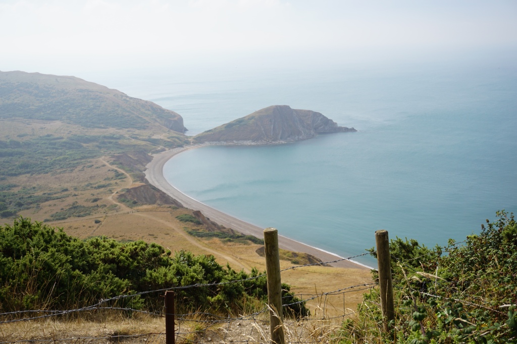
It is hard to get to; you have to walk quite a distance up a steep hill. Like a lot of the surrounding landscape, the fort is part of the military estate, so visitors are strictly controlled. The interpretation panel on site has the AFV Gunnery School cited at the top, so Flower’s Barrow may have been fired upon over the years. At the same time, being part of the military estate, there have not been the millions of pairs of feet that walk across the ramparts and wear away the very thing that they came to see. Usually on a hillfort, there is a regular pattern of visitor erosion, almost showing a ceremonial route etched into the ground creating a white chalk pathway. It runs along the top of the rampart, where people have circumnavigated the hillfort and taken in the views in all directions, and through the centre of the fort itself. There is a natural draw to the very heart of a fort. Not so on Flower’s Barrow. There is restricted access and we keep between the yellow poles sticking out of the ground.
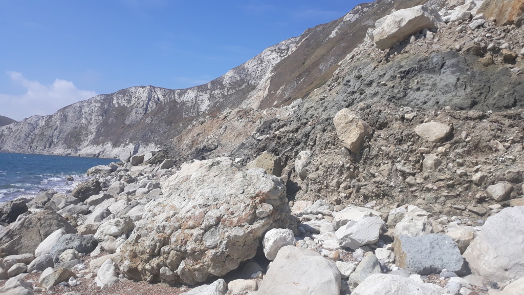
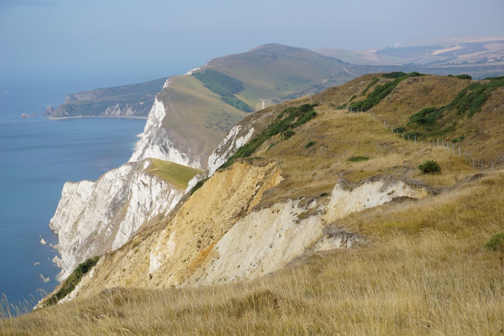
The fort is on of a ridge of hills that run along the coast of Dorset, east to west. This ridge rises and drops dramatically, creating a whole series of very steep hills and bays, such as the famous Lulworth. The north side of the hill is very steep and the road up takes a longer route to reduce the gradient. The southside of the hills have gone. They now face the sea and with a sudden and dramatic cliff edge, with a drop of perhaps 180 metres.
This ridge of hills are the same, geologically speaking, as the South Downs. In fact these beds link with those on the Isle of Wight. The Needles were once joined with Old Harry’s Rock near Swanage, which is at the very eastern end of this ridge. Kiplin wrote about the South Downs as “Our blunt, bow-headed, whale-backed Downs“. They do rise slowly then fall dramatically as with the back and head of the whale. This ridge of hills looks to me more like a sea dragon, or serpent with its long body rising and falling in and out of the water, tailing off into the distance. The chalk of these beds were formed 65 million years ago in a deep-sea environment and made of millions of tiny sea serpents.
At a guess, there is probably about a third of Flower’s Brarrow left. But what is left is substantial and gives a good impression what was there in the Iron Age. The ramparts are considerable and steep, rising to quite height. Similarly the ditches are deep. Within the fort itself, roundhouses and the other usual structures existed, but there is not much of the interior left, as it has fallen off the cliff, and most of it is off limits. I didn’t want to venture into the main area of the fort, due to the possibility of finding unexploded ordinance. I suspect the most interesting parts of the interior has fallen off the cliff onto the beach below and into the sea. I actually popped down to the bottom of the cliff below to see if I could make out any archaeological remains, but the beds and stratigraphy had been blended into one another with the collapse.
Barrows Hill was an earlier Iron Age hillfort and probably abandoned as an active settlement around 200 BCE. An obvious, logical link is that there was a strategic relationship other hillforts in the area that are not so far away. Maiden Castle is one, which is a huge hillfort with complex earthworks, especially the entrance. Flower’s is before the time of the huge complex Maiden Castle, but it would have been contemporary with the previous smaller Maiden Castle. There is evidence of it being used in the Roman and well into the mediaeval periods.
The site’s relationship with the landscape is there. There are the wonderful romantic views across the sea. I am not sure of the practical value of a romantic view had, but there would be site of passing ships. Worbarrow Bay and Arish Mell are just in sight, and other bays, such as Lulworth are not far away. These are good for landing boats, so there would have been sea travel, trade and contact along the coast, perhaps down to Cornwall and around to Wales. In the other direction, across the channel to north Gaul and beyond.
The ridge of hills Flower’s is on was probably the main overland route for travel and trade. Think of it as the main highway that ran east-west. Anyone travelling this route would have to pass through the hillfort. There was no space for going around it. Going eastwards this ridge ran to Studland and Swanage Bay, and just across the water is Hengistbury Head, a major Iron Age trading port and industrial centre, which shows how well-connect the area was. Again, the major activity at Hengistbury was later than Flower’s.

The low-lying areas to the north has many rivers riddling through it, with the potential for river transport inland. The immediate area at the foot of the hill would have been much boggier. When travelling by land, it would been easier on the higher ground.
Flower’s Barrow is prominent. Even today it is clearly visible from the below valley. What would it have looks like from a distance 2000 years ago with the wooden ramparts upon those banks? I mentioned before (Old Winchester Hill), how we tend to look out of the hillfort to the landscape and focus on the views. But what must have been important is the view to the hillfort from the surrounding landscape. The fort would have been a statement, a central focus and position of power to be seen from the sea and the land. I first spotted Flower’s when I was at Lulworth Castle just below the hill.
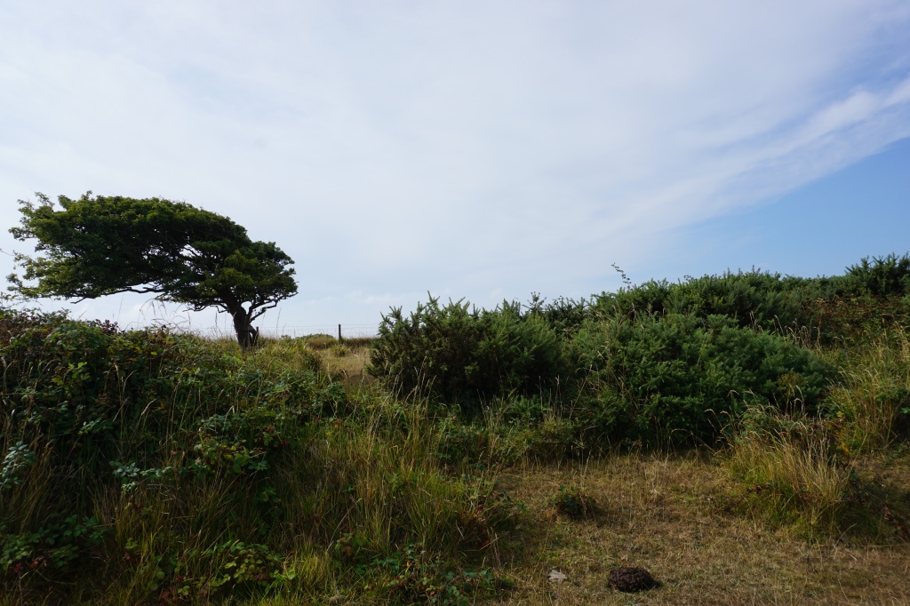
Looking at online reviews, almost everyone mentions the views; they also talk about the steep walk to get up there. You really do experience the sea from the cliffs, the winds, smells, noises, driving rain and beautiful views on a sunny day. There are trees on the ridge that look like they have been blown sideways by the incoming wind from the sea. The fog, which I experienced on the cliffs, completely envelopes you and detaches you from the outside world. There could be an edge of the cliff just in front of you, or another few miles of land. We talk about a blanket of fog, which is a wonderfully apt description. It protects you but also cuts you off from the world.
Those that live near the sea today say how it affects their everyday lives and improves their wellbeing. I agree. I grew up near the sea and miss it terribly. Would it be different then? Did the sea give the Iron Age people a sense of calm, belonging, awe? Perhaps more pertinent was what the sea represented. Travel by sea was dangerous, and I’m sure many friends and family were lost to the waves; the sea was a place of ancestors perhaps. In the Iron Age, water always appears to be the route to other worlds.

I must admit, I am surprised to find that so much has eroded over 2000 years. It made me think, did the ramparts go up to the edge of the cliff? Was there an open southern end to the hillfort that faced the sea, or did the ramparts completely enclose the settlement area? Even then, the cliffs would have been unstable and we all know you don’t go near a cliff edge; they have an unpredictable tendency to crumble away. I would like to think, there must have been a good amount of “space” between the ramparts, and the southern edge of the fort and the cliff. At least when it was built.
It also makes me think, what of the future? How long does it have left? The site is a scheduled ancient monument, which means that it is completely protected. We cannot damage it, and in particular dig holes in it. But it is disappearing, so do we excavate it now? Excavation is a destructive process. As soon as you excavate, the very thing you are trying to understand is destroyed. In the past, so much archaeology has been lost by antiquarians bulldozing their way through barrows. There is presently some excavation and survey work being carried out. Permission has been granted and an understanding of the site is underway.
Suffice to say, the longer it is left, the less there is. How long will it take to completely disappear can only be an estimation. The erosion is not so dramatic as at Dunwich. The chalk cliffs are harder and it will take much longer to erode, although in geological terms, it is a “blink of an eye”. Perhaps it will come quicker than we think. With a changing global climate, there will be more droughts that dry the soil and cliffs, making them more friable and even more prone to erosion. On top of that, more “tropical storms” will batter them away.
Dunwich disappeared quickly and in more recent times. There are memories of buildings falling into the sea, photographs, maps, archives and on the seabed, remains of the buildings. Whereas Dunwich was occupied right up to the last moment, Flower’s Barrow is the remains of what was abandoned over 2000 years ago. Now, we have a glimpse of the ruination of a ruin. It may appear to be static, but it’s not. The edge is receding, the scree on the cliff is constantly moving down towards the sea. In 50, or say 100 years, what will be there? Now is the time to record. The future of Flower’s is in the archive.
Thinking of that future, when it is gone, what will “we” think of it. Will there be a folk memory of it, with tales and mythological stories? Ghost stories perhaps? What will fill the void? Will the archive be easily understood; will this blog exist? Who knows.
References
The listing and technical details are found on the Historic England website: https://historicengland.org.uk/listing/the-list/list-entry/1008141?section=official-list-entry
The Review of Flowers Barrow is here https://www.megalithic.co.uk/article.php?sid=7528

“The ruination of a ruin” is a poignant line. I hope you get the chance to excavate before it disappears.
LikeLike
Thank you – I started with that line. I also had “the abondonment of the abandoned”, but thought it didn’t work.
Unfortunately, my excavation days are over, but I did see a team up there when I was there.
LikeLike