Last week I decided to walk up to the top of Meall Meadhonach, the hill (423m) just to the south-east of the village (I need to remember to call it “the village” instead of “town”!). I am hoping to go walking with my Bib Track walking friend in Wales next month, so need to start getting organised. Most of my gear is still OK from my last visit here but I’m not in practise and I have the added complication of the dog. I’d like to take him with me so need to get him accustomed to multi-day hikes. I haven’t got him used to the tent yet so have been thinking of doing a two day trip to Strabeg bothy (just to the south of Loch Eriboll) and back which gives us the overnight experience without the hassle of the tent. Hopefully the view from the top of Meall Meadhonach would give me a better feel of the lay of the land in that direction.


It didn’t really take me 5 hours – I just forgot to turn the logger off. And stopped for tea and cake at a friend’s place! Also, given its propensity to over-read, it was probably only 12ish km.
We were also testing my old dog packs on Merlin. I discovered pretty early on that anything I was going to put in them would have to be completely waterproof. They sat very well though and didn’t seem to bother him at all. They also made him a lot easier to spot on the hillside!


It was a beautifully fine, but reasonably windy, day when we set out. It was warm enough though and I soon took my beanie and gloves off. The start of the walk followed the trail from just east of the Smoo Hotel turnoff, up to the bealach. Just before the high point on the pass a quad (ATV) path turns off to the right.

This is where the path leaves the main track. You can only just see it.

The path becomes much clearer after a while
I started following this but as usual, the “path” was worse than walking cross country. I also kept wandering off it without noticing, looking around to realise that it was “over there”. Eventually I gave up on the path and took the much more interesting route wherever my feet took me. Besides, straight up the side and then walk along the top is a much more fun way of doing it than following a path!

Looking back down to realise I’d missed the path again. You can also just make out a marker post to show this is a “real” path. Loch Eriboll in the background.

The way I went instead

and I was rewarded by a view of this lovely lochan
I headed up close to the top of the ridge then headed west up towards the peak. I got distracted at this point and decided to head to the southern end of the peak to have a look down towards Strabeg. This section was reasonably rocky, with what looked like slabby quartzite. It was good to see that Merlin wasn’t worried by the uneven rocky surface.

Looking north-east on the slabby ridge end. Merlin obediently posing for me. The mouth of Loch Eriboll to the left.
If it was reasonably windy when we started, it was now extremely windy. It was very difficult to stand still, let alone steady enough to take photos and Merlin kept walking into me, misjudging the wind as he walked past. I had to be very careful when standing on the edges of the peak or on rocky ground, especially while taking photos. The wind actually made it so cold that I couldn’t leave my mouth open or my teeth started hurting! Merlin seemed a little bemused by the wind, but was at least obliging enough to stand for a photo. See, no more dodgy selfies now that I have a reasonably obedient companion!

Looking south-west to Beinn Spionnaidh (it is on my list)

Looking south-west to the end of Loch Eriboll. Strabeg is somewhere beyond the water to the right.
From here it was onto the peak proper. If anything, it was even windier up there. Merlin almost knocked me off the edge by walking into me (blown by the wind) when I was standing on the edge. He then hid behind the cairn while I tried to get some scenery photos. He did peer out to try to work out what I was doing standing out in the wind for so long!

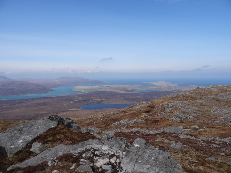
The view back to Durness, Faraid Head and the Kyle of Durness from the summit. The closest loch is Loch Meadaidh, with the smaller further one being Loch Caladail.
I had brought a sandwich for lunch and was going to hide behind the cairn and eat it but remembered a comment I read recently about “cairn hoggers” and how it should be illegal to consume sandwiches at a summit cairn. Even though there was no-one else around I obligingly descended a little way (luckily to the north, away from the wind) and found a nice outcrop to hide behind. The gloves and beanie definitely came back on at this point!
I wanted to traverse the rest of the summit on the way back so headed north, then north-west, across all of the subsidiary peaks and up and down a series of lovely gullies. There are some beautiful long outcrops of pink granite in these. There is actually quite a lot of very coarse grained pink granite up here, mixed in with the dark grey gneiss, creamy limestone and white/grey quartzite.

Looking east along a gully.

Pink granite streaks in a gully
I came straight down from the side of the hill, making a beeline for the bealach path just to the west of where it crosses a stream (saving me from crossing the stream). It was not the ideal descent path, being quite steep and very slippery. However, I do like taking the direct route, especially on the way down!

Looking back to where I came down from where we rejoined the main track.
I think Merlin was actually tired by this point. He walked along next to me for a while (rather than bounding through the heather and criss-crossing backwards and forwards). He soon decided that this would ruin his reputation though so started play-bowing and trying to play with me . . . which was amusing until he wiped mud all over my nice yellow fleecy!
The walk back was lovely for the view ahead of me, but also kept interesting by the fighter planes flying over me and the occasional booms and puffs of dust from An Garbh-eilean, an island off the coast of the cape. I did capture a dust cloud on one of my photos, and actually saw the flash of one bomb. It was taking about 25s for the sound to reach me though so it was a matter of seeing the plane fly overhead, watch it till I lost sight of it in the clouds, then guess how long it would take to get to the target and not blink for as long as I could!

On the way back into town.

This is just a crop of the previous picture. You can just see the dust cloud coming from the island where the bomb has hit it.
They were doing aerial bombing exercises all this week. On Monday I walked out to the end of Faraid head to watch them – unfortunately the cloud cover was so low (and it was wet, cold and windy) that I didn’t see a single plane, or the bombs, but did see lots of dust clouds and a couple of light flashes.

The view from Faraid Head earlier in the week.
I actually did some flora identification when I got home, after taking a photo of an interesting looking plant. It is called “Fir Clubmoss”, and the photo also contains Ling Heather (the commonest type I think) and Cladonia Lichens (I think – the stringy looking white things.

The green thing in the middle is Fir Clubmoss
I also saw a lot of grouse (which Merlin startled but completely failed to “set”, and some of which he didn’t even notice when they flew up from under his nose!) and took a photo of some grouse tracks for you, which Merlin kindly walked across to give you some idea of scale (bear in mind he is huge).


You must have better eyesight than me because I cannot see the bomb dust even in the cropped photo. I think you should make Merlin carry his food in his pack and then if he gets soggy biscuits every night he may learn not to go in the water. Na, that will never work with him.
what gorgeous landscapes!!! and good to see merlin enjoying himself too! glad you both are well. much love x
Love the photos and happy to hear you are enjoying scenic, windy, walks together. Next time, attach a kite to Merlin’s pack. That’ll make him even more easy to spot 🙂
That is quite a good suggestion!