
We continue our trip around some Cornish hamlets with a visit to Tregeare in the parish of Egloskerry.
Tregeare was recorded in 1416 as ‘’Tregayr’ translating from the Cornish language ‘tre ger’ meaning ‘farm by a fort’. From this, we can conclude that the name probably derives from the hillslope enclosure to the north of the farmstead at Tregeare Rounds.
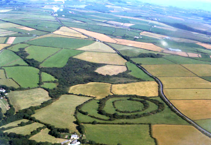
Tregeare Rounds, once recorded as ‘Dameliock Castle’ with this being a false name, was excavated in 1902 by S Baring-Gould.
This excavation suggested that human occupation was restricted to the area between the two main ramparts where finds consisted mainly of slingstones, perforated stones, spindle whorls and pre-Roman pottery.
The terminals of the innermost bank are raised up, presumably providing vantage points for those overseeing the herding of cattle in the centre of the fort. This seems to have been the purpose for which these hillslope forts were designed, probably dating from the second and first century BC.
Tregeare Rounds was surveyed by the Ordnance Survey in 1976 and comprises two sub-circular univallate and concentric enclosures totalling six and three-quarter acres, and on the eastern side, a five feet high scarp forming a curvilinear outwork encompassing a further three and a quarter acres.
The inner enclosure, of 295 feet internal diameter has a bank which averages six foot six inches high and a pitch up to six feet deep, with an overall width of just over 39 feet.
The outer enclosure of 558 feet internal diameter is much stronger; its rampart averages 10 feet high, the ditch six feet deep and the overall width exceeds 65 feet.
In the southeast a sunken way across the interspace of the outwork leads to simple entrances through the main and inner ramparts though in each case a low scarp extends across the gap. The relationship of this sunken way to the outwork is uncertain and complicated by the construction of a field bank.
In the north the outer ditch incorporates one shallow causeway which may be the result of ‘gangwork’; other interruptions appear to have occurred through agricultural activity and the 1902 excavations.
A Cornish ‘hull’ is excavated into the side of one of the outer ramparts of Tregeare Rounds. This is described as an “adit 51ft long 5ft wide and 6ft high”, with soil from the excavation placed some distance away.
Cornish historian Michael Tangye describes hulls being used for underground storage of potatoes, cheese and other foodstuffs.
At one time Tregeare Rounds became associated with Arthurian legends:
The Arthurian associations of Castle Killibury stem from attempts to discover the location of Kelli wic, the name given in both Culhwch ac Olwen and Trioedd Ynys Prydein to Arthur’s residence in Cornwall. In 1900 Castle Killibury was suggested as Kelli wic for three main reasons: firstly that a hill-fort would be the most appropriate identification; secondly that the names Kelli wic and Killibury are similar; and thirdly because it was near Tregeare Rounds. This last argument is the one that tipped the balance in favour of this site, when the name alone gave it no better case to be Kelli wic than, say, Callington and Calliwith. This argument is, however, false.
See http://www.arthuriana.co.uk/n&q/artharch.htm
With thanks to Myghal Map Serpren.


Leave a comment
Comments feed for this article