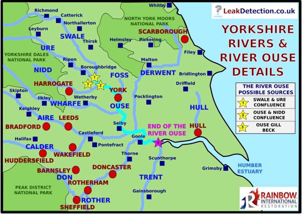
In our recent reports on the the key Yorkshire Rivers and a separate article focusing on the Yorkshire Dales Rivers, one of the rivers we discussed in detail is the River Ouse, which is the main river flowing through York, as you can see on our River Ouse map below – the River Ouse is highlighted in light blue.
On this River Ouse Map, you will notice that we have highlighed a few places (with yellow stars) to show were the, somewhat disputed, source of the river ouse is. We will clear that one up later!
Before that, a quick recap on the River Ouse;
The River Ouse Map: Guide
- Overview – The River Ouse is one of several rivers coming under the control of the Yorkshire Dales Rivers Trust. There are several ‘River Ouses’ in the UK, including the River Great Ouse central England. It is also somewhat infamous for flooding, in particular causing flood damage in York over the years.
- The Source of the River Ouse – there are a few different thoughts about the source of the River Ouse and this causes some confusion. However, we will clear this up later.
- The End of the River Ouse – this is much clearer and shown on the River Ouse Map above with a pink star and text at ‘Trent Falls’ which is actually the confluence of the Ouse and Trent, which flow into the River Humber to form the Humber Estuary near Hull in East Yorkshire.
- Locations on the River Ouse – famously include York (where we are based), we do a lot of leak detection in York. Other places include, Bishopthorpe, Naburn, Acaster Malbis, Cawood, Riccal, Barlby, Selby, Hook, Goole, Swinefleet and Ousefleet along the route. When passing through York, the River Ouse flows under several York Bridges. It is in this area that the Viking Recorder river level monitoring station is located too.
- The River Ouse Length – is 84 kilometres or 52 miles long from start to finish
- River Ouse Waterfalls – the River Ouse is not known for waterfalls, mainly because it forms on flatter land (in the Vale of York) and continues that way until it reaches the Humber as seen on our River Ouse Map.
- The River Ouse Catchment Area – is 3,315 km² or 1,280 square miles, which is very large and, in part, explains why it is associated with flooding. It is also made up of catchments from other rivers as you can see from the River Ouse Map above. Most notably this includes the River Swale, River Ure, River Nidd, River Wharfe, River Calder, River Aire and River Don. We will show some of the places these rivers join later.
As experts in fire and flood restoration, we are very familiar with the River Ouse flooding.
Where is the Source of the River Ouse?
Let’s try to clear this up and see which of the three places marked on our River Ouse Map is actually the ‘official’ source of the River Ouse. The three contenders we will discuss are:
- The Confluence of the River Swale and River Ure – between Aldbourough and Myrton on Swale
- The Confluence of the Nidd and River Ouse – near Nun Monkton, west of York
- Ouse Gill Beck – close to the villages of Great Ouseburn and Little Ouseburn
Each of these places is marked, with the numbers on this list, as stars on our River Ouse Map, which we have zoomed in on below to show the three possible sources:

Let’s now look at those one by one below to see which is the right one on our River Ouse Map.
Note – this picture is taken at this point shown on Google Maps
River Ouse Source #1 – Swale & Ure Confluence
A quick reminder that that a ‘confluence’ is the name given to where two rivers join.
If you were to quickly look on Google Maps tracing back west of York, shown on our River Ouse Map, one of the obvious places you come to is where the Swale and Ure rivers meet. This is shown in the picture above with the Swale on the left and the Ure on the right, this is repeated in the picture looking upstream from the same vicinity.

So is this where the River Ouse starts? Basically, no. In actual fact, where the Rivers Ure and Swale meet, from that point on it continues as the River Ure (and so the Swale ends there) further downstream, as can be seen on Google Maps, close to our other two possible locations on our River Ouse map, let’s look at those now.
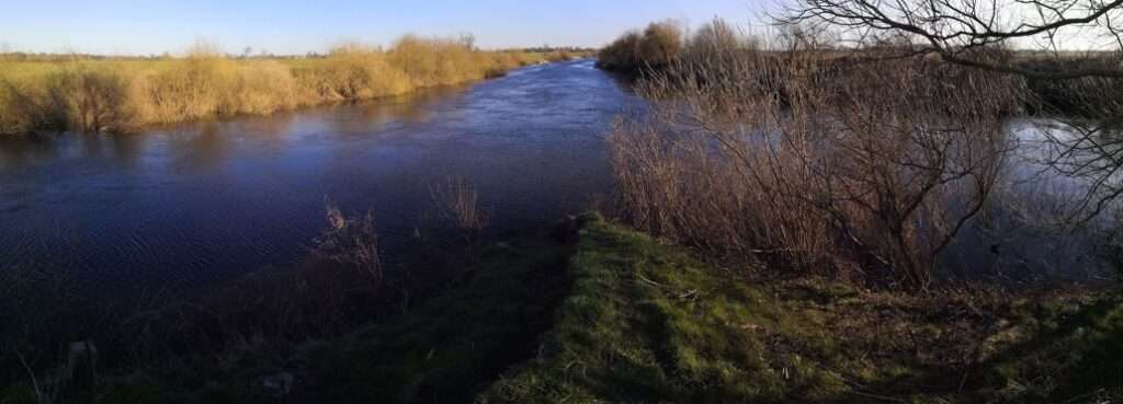
River Ouse Source #2 – Nidd & Ouse Confluence
Just west of York, at the village of Nun Monkton, there is another location where two rivers meet which looks like it could be where the River Ouse, as shown in the picture below:

Note – this picture is takem close to this point shown on Google Maps
In this picture, you can see the River Ouse going straight ahead down towards York, on the right is the River Nidd, so what is the river is it on the left. Well we know that from above, upriver where the Swale and Ure meet, it continues as the River Ure, so it is the River Ure? No, it’s not. It is actually the River Ouse.
So at some point between these to places on the river, it switches from the River Ure to the River Ouse, but where is that and where does the river ouse actually originate? Let’s look at the final condender next.
River Ouse Source #3 – Ouse Gill Beck, Great Ouseburn
Last on our list of places on our River Ouse map marking possible sources of the River Ouse, is Ouse Gill Beck near the village of Great Ouseburn, west of York. This point is seen here on Google Maps.
As you can see from that place, it isn’t a river, it is where ‘Ouse Gill Beck’ starts, where a spring rises. In fact, on that page we linked to earlier from the Yorkshire Rivers Trust site, it says “The stream at the source is Ouse Gill Beck which rises as a spring near Great Ouseburn, marked by a pillar inscribed ‘Ouse River Head’”
Here is a picture of that pillar:
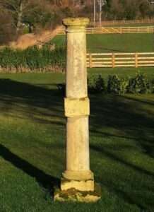
As you can see, that spot (marked as the star with a number 3 on our River Ouse Map) doesn’t actually look much like a river, let alone a major one! So is that the source of the River Ouse?. Well it depends on your viewpoint, it is the point marks the start of Ouse Gill Beck, the furthest upstream water source of the River Ouse, which meanders somewhat before reaching this point as the ‘actual’ River Ouse. Interestingly, on Google Maps, the River shows as the River Ouse before that point, but then there is a gap in names on the map (Ouse vs Ure) until beyond Aldwark bridge where it starts saying River Ure.
So, in a nutshell, the River Ouse original source of water is at Ouse Gill Beck, but where it starts as the River Ouse as we know it is where the beck reaches the River.
Interestingly, York is fairly well known for flooding, particularly from the River Ouse, River Foss and, in the city centre in particular (as can be seen in this example video below) but in actual fact, many of those riverside properties and businesses have measures in place to help with flood resilience in York. Flooding beyond this area in York, is relatively uncommon, especially since the York Flood Defences have improved. That said, people in York are still usually on the lookout for river levels in York.
If you want to find our more about York and its atractions, please see our interesting article showing the top 5 things to do in York, which we collated based on our local knowledge of working and living in the area.
We are experts in dealing with flood water damage for people in the York and Yorkshire Coast area, so if you have been flooded, please contact our friendly team to arrange for help and guidance. We also deal with water leaks in Yorkshire homes and businesses. As you might expect, many of our customers get their water supply from Yorkshire Water who collects, treats and supplies water from some of the rivers of Yorkshire above to supply to their network of customers across Yorkshire. Here are the local areas we cover.
Top Tip
Leak Detection Team
“Flooding from rivers in the UK does not always come from rain directly in towns and cities on those rivers. It often comes from rain higher upriver in the wider catchement areas and tributaries. Watch for rain in those areas to understand what might happen to river levels soon after. How long it takes to arrive will depend”.
We hope you found our River Ouse Map and guide useful and informative. The whole area around York is very beautiful and the various rivers help to contribute to that beauty. But as we have seen, they do carry risks so if you are exploring or visiting the areas, do please take care and be on the lookout for flooding in those areas.
At Rainbow Restoration – York & Yorkshire Coast we are experts in Leak Detection and Water Damage Restoration, so if you need help finding a water leak or getting your property back to normal after a leak or flood, get in touch with our friendly local team who will be happy to help you with this.
We mention the River Ouse in our guide to Christmas flood safety.
Is there a river through York?
Yes there are two famous rivers that flow through York. The largest, most famous and most prominent is the River Ouse which flow through the city centre of York. The other river is the River Foss which, although also close to the centre, is generally less prominent.
Can you walk along the river in York?
There are many walkable pathways alongside the rivers of York, in particular the River Ouse which flows through the city centre of York and has pathways along much of the North and South Bank of the river. There are several pubs, restaurants and hotels close to the rivers too.
What is the river in York called?
The main River in York is called the River Ouse, but there is also the River Foss close to the city centre two. Both of them merge at a confluence to the east of the city centre, near to the Foss Flood Barrier.