
Yesterday in the fine sunny weather, and carrying a copy of the 1930’s aerial photo of the bronze-age bowl barrows in Brentmoor Heath, I ventured out to find the elusive fifth bowl barrow.
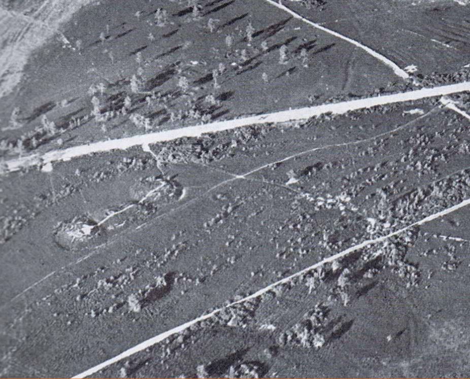
The photo, below, of the bowl barrows clearly shows the group of four bowl barrows. Less clear is the smaller bowl barrow, indistinct it might be, is the small circular barrow, which can be seen just to the right of the larger barrows. Below this photo is what I discovered.
I tramped around the heathland looking for evidence of the fifth barrow. Not having exact measurements of its location it was always going to be difficult to locate, and so it proved.
I think I found the likely location, although there was no obvious evidence, just an intelligent guess on my part from holding the photo in my hand, and judging where it might be in relation to the other barrows.
Here are two photos of what I found. The first photo looks back the the four barrows – the information board can be seen in the distance. The guess of the location is directly behind the tree at the right in the photo. The second photo is my guess of the location of the fifth barrow. My walking pole can be seen in the background to give a sense of scale. [click on photos to expand]


Interesting Timster !
Other options: According to an SHBC report, the summit of the hillock where the two paths ‘leaving’ your pic on the rhs is another barrow … theres been much disturbance over the centuries – with more recent Army activity & now a kids MotoX track … but looking from the vantage point of the open area to the south, its certainly a potentially artificial hillock !
Similarly, if you follow the high ground around the almost horseshoe shape of the countours, Cuckoo Hill might be another candidate !
So, from the tips of the Higher ground Horseshoe contour line, would make a processional path past the remaining 4 Barrows I’d opine ….
IYSWIM !
LikeLike
Speedicus, you’re comment is intrguing. I think Cuckoo Hill might be a bit to far away. Please do tell about the SHBC report you mention.
Also discernable from the photo is the ring, made by horses, adjacent to the entrance to the Grenade Range, which could help locate the site. I think I need to contact archaeologists to find out more, and to overlay a modern map over the 1930’s photo, which I hope would make the discovery of the site more accurate than my guesswork.
LikeLiked by 1 person
The report was on the SHBC site a few years back – I sought it out after the occupants of the last House in the New England row mentioned they thought it was the ideal site for a Barrow – on the skyline (as is Cuckoo Hill at the other end of the ‘horseshoe’ ) – apparently the ‘Ancients favoured high vantage point sites for thse Barrows – the Sunningdale one is similar I believe…..
The well-beaten track that crosses the summit of the little hillock is apparently an extension of the track past the Houses – it was originally called ‘The Gallop’ … established long before the Army built todays Red Road to Folly section ….
Look at the contour lines on a map to see how the 3 points on the highest contours are related …. probably my vision of a Ceremonial route is wishful thinking, but it makes a great mental picture !
I’ll see if I can find that Report again – it was written I recall by a Staff person, not an Archeologist per se, and isnt very ‘technical’ …
LikeLike
cant find the report – but the presence of a barrow is acknowledge when you search for Scheduled Monuments:-
Are there any Scheduled Monuments in Surrey Heath?
“Bee Garden” earthwork on Albury Bottom (O.S. Map Reference SU 974 643)
Earthwork NW of Childown Farm on Chobham Common (O.S. Map Reference SU 994 638)
Four bowl barrows on West End Common (O.S. Map Reference SU 9343 6135)
Bowl Barrow at New England, West End Common (O.S. Map Reference SU 9361 6129
LikeLike
… and again on this site – in fact the wording reads much the same as I remember on that SHBC Report years back …
https://historicengland.org.uk/listing/the-list/list-entry/1018505
LikeLike
Speedicus, you are a wizz at research. Thank you for your knowledgeable help. The Historic England documents put the barrow nearer to New England that I had considered, and in line with your thoughts. Ah well, another excuse to go investigating into the heathland, which I rather enjoy.
Am busy for a while, so will post follow up to your comments as soon as I can. Again, many thanks for pointing me in the right direction.
LikeLiked by 1 person
Tim, thats not to say that the Barrow you spotted in the old Photo – nearer to the 4 incumbents & the Red Road isnt one in its own right !
I wonder if the Army have any 1950s-1970s photos of the area – they cared enough to stop their tracked vehicles from rolling rough-shod over the original 4, by digging a ditch around them !
LikeLike