By Jackson Radler
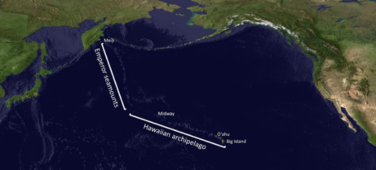
Okay, your gut is right, there aren’t actually Hawaiian islands north of Alaska, but there are many more landforms associated with Hawaii than you may realize, and some of them are located north of Alaska. What do I mean by this? Let’s step back for a minute. Islands are just mountains in the ocean that happen to be taller than the ocean is deep. What about oceanic mountains that don’t quite…rise to the occasion? Geologists call these landforms “seamounts”, i.e. underwater mountains (Figure 1). Seamounts and volcanic islands are actually different stages in the life cycle of an oceanic volcano.[1] In the case of the Hawaiian system, there is a chain of over 100 individual volcanoes stretching northwest across the Pacific Ocean, with the northernmost member (Meiji seamount) lying further north than parts of Alaska (Figure 2).[2]

The Hawaii-Emperor Chain
The Hawaiian archipelago is a group of above-water landforms stretching 3,500 km west from the Big Island—a distance comparable to that between NYC and Salt Lake City. The Emperor seamount chain (named for Japanese emperors) continues as a series of seamounts for another 2,500 km northwest (Figure 2). In total, the Hawaiian-Emperor chain system stretches over 6,000 km away from the Big Island, with the northernmost seamount Meiji coming within 240 km of mainland Russia. Of all the landforms (above & below water) in the Hawaii-Emperor chain, the Big Island is the highest, rising 4481 meters above sea level. The islands progressively decrease in elevation to the northwest, until they are near-equal with sea level, and the trend continues underwater as the Emperor seamount chain (Figure 3).[2]

Life Cycle of a Volcanic Island
Each oceanic volcano creates some kind of landform, and they are classified based on their height above or below sea level. While underwater, oceanic volcanoes form seamounts, but new material is deposited as magma erupts and cools, resulting in growth. Eventually, enough material is deposited to for the volcano to rise above water, at which point it is considered a volcanic island. If the volcano goes extinct, the corresponding seamount is resigned to a destiny of slow erosion.[1]
Landforms borne of active or recently-active volcanoes usually rise well above the water, forming high islands (e.g. Hawaiʻi and Oʻahu). Some volcanoes have gone extinct, eroded over time, and now sit barely above sea level, forming low islands, i.e. atolls or shoals (Midway Atoll is a great example, famous for its role during WWII). Other volcanoes are long extinct, and erosion has reduced their height such that they no longer protrude above water (e.g. the Emperor seamounts).[2][3]
Hotspot Volcanism
So why is there a chain of 100+ volcanoes in the middle of the Pacific, and why does it extend for 6,000 km? To answer these questions, we need to dive into the processes that drive volcano formation.
In the 1960s, the prevailing theory was that volcanoes form at the boundary between tectonic plates, the classic example being the Ring of Fire surrounding the Pacific Ocean. However, when no such boundary was found along the the Hawaii-Emperor seamount chain, JT Wilson (1963) proposed a new theory: that an unusually hot plume of magma could penetrate through an unusually thin area of a tectonic plate, forming a volcano distant from any tectonic boundary (Figure 4).[4] Christopherson (1968) termed these areas hotspots (you may be familiar with the famous Yellowstone Hotspot in Wyoming).[5]

The Hawaiian-Emperor volcanic chain was formed by the Hawaiian Hotspot in the middle of the Pacific Plate. Volcanoes develop on the Earth’s outermost layer, the crust, but the magma that feeds them comes from the mantle layer situated just below. In theory, if everything stayed stationary, one hotspot would continuously feed one volcano. In reality, tectonic plates move over time, while hotspots remain relatively fixed in place, which results in a series of individual volcanoes forming in a line (Figure 4).[3]
New volcanoes continue developing over the hotspot and—through repeated eruptions—build themselves up thousands of meters, high enough to rise above sea level. As their tectonic plate drifts, volcanoes are moved farther from the plume of magma that feeds them, and eventually they lose connection with the magma flow, resulting in an extinct volcano. Tectonic movement continues to carry these extinct volcanoes further away from their hotspot of origin, while simultaneously the process of erosion slowly reduces their height.[6] The Hawaiian Hotspot has been exhibiting this pattern for a long time: the younger volcanoes in the system are to the southeast (youngest: Kīlauea, 0.3-0.6 million years old[7]), while the older volcanoes are to the northwest (oldest: Meiji, ~81 million years old) (Figure 5). It is hypothesized that the the Emperor seamounts used to stand thousands of meters above sea level, much like the 8 major islands of Hawaii today, but erosion has reduced their stature. This explains the trend observed in the Hawaii-Emperor seamount system: islands & seamounts further from the Big Island are shorter because they are older (Figure 6), and thus have experienced the forces of erosion for a longer period of time.[6]


Conclusion, and a Look to the Future
The Pacific Plate has continued to drift, and there is a new volcano in the ocean southeast of the Big Island actively building itself higher. Figure 5 (right) shows the newest volcano in the Hawaiian chain, Lōʻihi seamount, though was recently renamed Kamaʻehuakanaloa (“glowing child of Kanaloa”) by the Hawaii Board on Geographic Names. While its summit is approximately 1,000 meters deep, and not expected to reach the ocean surface for millions of years, Kama’ehuakanaloa is already making its presence known, triggering earthquakes that are felt on the Big Island.[8] Perhaps one day our descendants will be able to watch the youngest member of this volcanic system emerge from the ocean, forming an island all of its own.
TL:DR
- Seamounts are underwater mountains. Most are volcanic in origin, and used to be volcanic islands that are now weathering away.
- The Hawaiian Hotspot has produced over 100 volcanoes in a chain (that we know of) as the Pacific Plate has moved over time.
- The Hawaii-Emperor seamount chain includes not only the 8 major Hawaiian islands but also 100+ atolls, shoals, and seamounts, all volcanic remnants.
- The Hawaii-Emperor seamount chain stretches from the Big Island nearly to Russia.
- A new Hawaiian volcano is on the rise and is expected to surface in a few million years (stay tuned!)
References
- US Department of Commerce, N. O. and A. A. (2015, July 20). 2015 Hohonu moana: Exploring deep waters off hawaiʻi. Background: Seamounts: Underwater Islands of the Pacific: NOAA Office of Ocean Exploration and Research. Retrieved April 17, 2023, from https://oceanexplorer.noaa.gov/okeanos/explorations/ex1504/background/seamounts/welcome.html.
- Jiang, Z., Li, S., Liu, Q., Zhang, J., Zhou, Z., & Zhang, Y. (2021). The trials and tribulations of the Hawaii hot spot model. Earth-Science Reviews, 215, 103544. https://doi.org/10.1016/j.earscirev.2021.103544
- US Department of Commerce, N. O. and A. A. (2010, March 1). How did the Hawaiian Islands Form? NOAA’s National Ocean Service. https://oceanservice.noaa.gov/facts/hawaii.html
- Wilson, J.T., 1963. A possible origin of the Hawaiian islands. Can. J. Phys. 41
- Christofferson, E., 1968. The relationship of sea-floor spreading in the Pacific to the origin of the Emperor seamounts and the Hawaiian chain. EOS, AGU Trans 49, 214.
- US Geological Survey. Evolution of Hawaiian volcanoes. Hawaiian Volcano Observatory. https://www.usgs.gov/observatories/hvo/evolution-hawaiian-volcanoes
- US Geological Survey. Kilauea. Geology and History. https://www.usgs.gov/volcanoes/kilauea/geology-and-history
- US Geological Survey. Volcano Watch – Kamaʻehuakanaloa – the volcano formerly known as Lōʻihi Seamount. Hawaiian Volcano Observatory. https://www.usgs.gov/observatories/hvo/news/volcano-watch-kamaehuakanaloa-volcano-formerly-known-loihi-seamount

Pingback: Get on the write track for an LTS blog post | Lions Talk Science