Wat Lam Chang
Wat Lam Chang is a Buddhist temple in Si Phum, Mueang Chiang Mai, Chiang Mai Province. Wat Lam Chang is situated nearby to the art gallery Paw Tonn and the place of worship Wat Chiang Man.Photo: DerFussi, CC BY-SA 3.0.
Notable Places in the Area
Wat Chiang Man
Buddhist temple

Photo: Supanut Arunoprayote, CC BY 4.0.
Wat Chiang Man is a Buddhist temple inside the old city of Chiang Mai, in northern Thailand. Wat Chiang Man is situated 140 metres northwest of Wat Lam Chang.

Wat Chiang Yuen
Buddhist temple
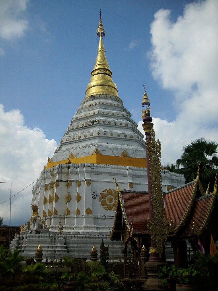
Photo: Јованвб, CC BY-SA 3.0.
Wat Chiang Yuen is a Buddhist temple in Chiang Mai, Thailand, located north of the Old City, about 600 metres east of Wat Lok Moli. Wat Chiang Yuen is situated 410 metres northwest of Wat Lam Chang.
Localities in the Area
Chiang Mai
Photo: Tevaprapas, CC BY 3.0.
Chiang Mai is the hub of northern Thailand. With a population of over 127,000 registered residents in the city municipality, and 1.2 million in the urban city area as of 2022, it is Thailand's second-largest city.
Chang Phueak
Neighborhood
Chang Phueak is a tambon of Mueang Chiang Mai District, in Chiang Mai Province, Thailand.
Nong Pa Khrang
Town
Nong Pa Khrang is a tambon of Mueang Chiang Mai District, in Chiang Mai Province, Thailand. Nong Pa Khrang is situated 4 km east of Wat Lam Chang.
Wat Lam Chang
- Type: Buddhist temple
- Description: Buddhist temple in Chiang Mai, Thailand
- Categories: wat, place of worship and religion
- Location: Si Phum, Mueang Chiang Mai, Chiang Mai Province, Northern Thailand, Thailand, Southeast Asia, Asia
- View on OpenStreetMap
Latitude
18.79306° or 18° 47' 35" northLongitude
98.99052° or 98° 59' 26" eastOpen Location Code
7MCWQXVR+66OpenStreetMap ID
way 265150050OpenStreetMap Feature
amenity=place_of_worshipWikidata ID
Q18608494Wat Lam Chang Satellite Map
© OpenStreetMap, Mapbox and Maxar
Also Known As
- English: Wat Lamchang
- German: Wat Lamchang
- Japanese: ラムチャン寺
- Korean: 왓 람 창
- Thai: วัดล่ามช้าง
Landmarks in the Area
- Paw TonnArt gallery
- Wat Chiang ManPlace of worship, 140 metres northwest
- Thai Farm Cooking Class180 metres northeast
- Yupparaj Wittayalai SchoolSchool, 210 metres southwest
- Urban Development Institute FoundationPublic building, 300 metres south
Places in the Area
- C. M. Blue HouseGuest house
- ZMOYCoffeehouse
- R. C. N. Court and InnGuest house
- Lita Guest HouseGuest house
- Rocky Custom TailorClothing store
Popular Destinations in Chiang Mai Province
Discover Chiang Mai, Doi Inthanon National Park, Samoeng and Chiang Dao.
Escape to a Random Place
Discover other Buddhist temples in the world.
About Mapcarta. Thanks to Mapbox for providing amazing maps. Data © OpenStreetMap contributors and available under the Open Database License. Text is available under the CC BY-SA 4.0 license, excluding photos, directions and the map. Photo: DerFussi, CC BY-SA 3.0.