Archive for the ‘Oakland chert’ Category

The Skyline chert exposure

1 August 2022

For several miles starting near the top of Marlborough Terrace, Skyline Boulevard runs through a belt of blond chert that makes for striking roadsides and some of Oakland’s highest homes and best views. Near the south end of this stretch, north of Elverton Drive, the road runs east-west for about 700 feet. It’s just you, the view, and these rocks. In my book I describe them as “pale, flinty chert in layers a few inches thick alternating with thinner layers of soft brown shale. The layers, thousands of them, stand on end like a storm-swept forest of golden bamboo.”

Note that the nice wide verge is now blocked by a line of huge logs. These extend for miles along Skyline and Grizzly Peak Boulevard. There are still small places to park, though.

Here’s the location on the map. The land is an outlier of the Sibley Volcanic Regional Preserve, and a little trail runs along the ridgetop between the two boulevards.

The rock in this roadcut is chert: a hard, waxy-looking stone made from accumulations of microscopic diatom skeletons. It ranges from white to brown to black, simple to complex. It dates from the middle of the Miocene epoch, probably the Tortonian age around 12 million years ago.

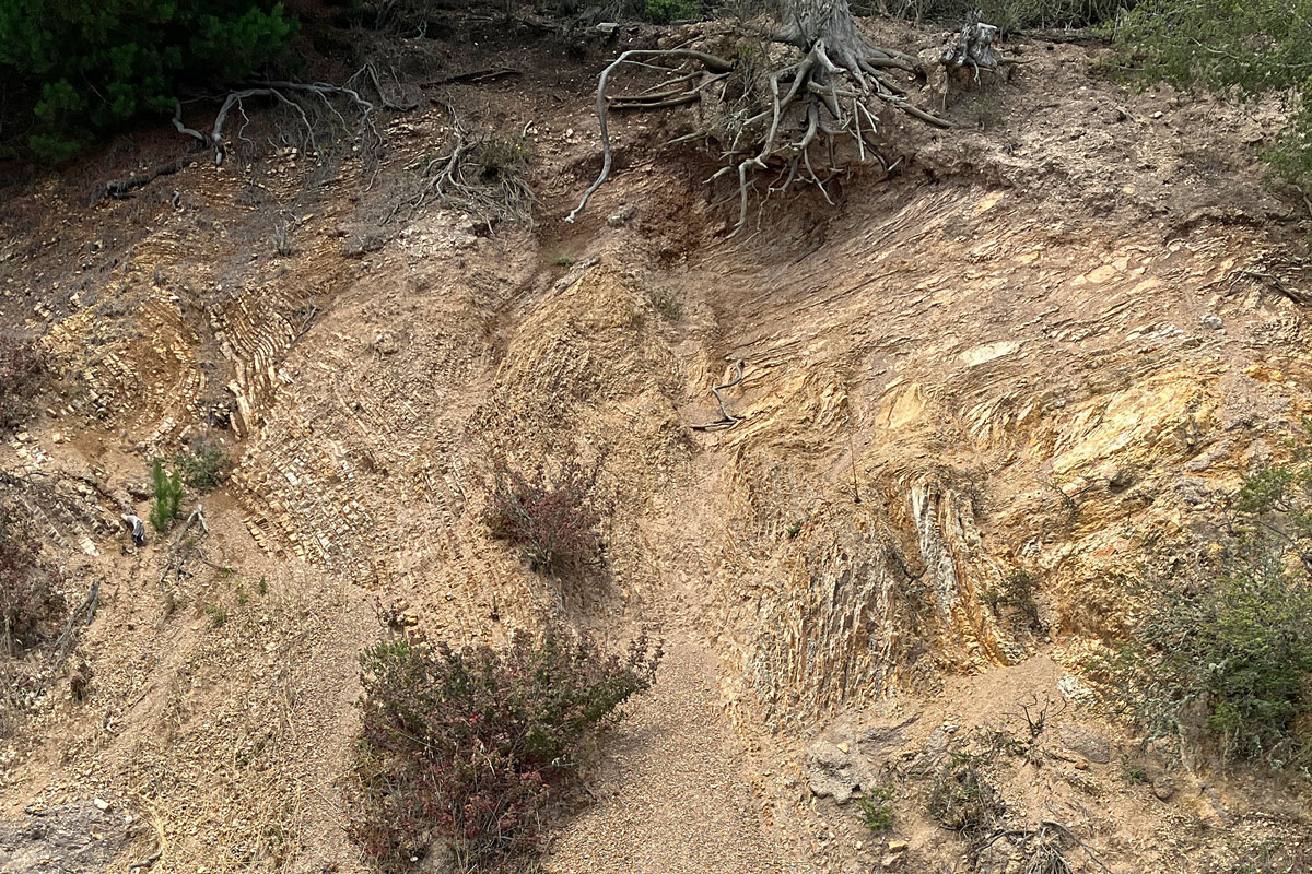
The complexity extends to the larger, outcrop scale. Notice how the straight, even bedding on the left gives way to distorted layers on the right. The boundary between them is a fault. There are several more along the roadcut.

In addition to the faulting, this even-bedded, slowly accumulating sediment was periodically disrupted while it was still soft, presumbly by large undersea landslides triggered by earthquakes, just like today. Here’s a more extreme example; notice the wisp of chert entrained in the mixture on the left.

Here’s a foot-thick bed of clean white sandstone, preserving an ancient submarine landslide. By the way, it appears that nearly all of these rocks are overturned, their upper surfaces now facing to the right.

In the middle part of the roadcut, it really gets hairy. (This is the biggest image of the set.)

Other parts of the roadcut look tidy and regular, but erosion has cut into softer parts of the formation in the century since Skyline was built to attract developers.

Here’s a closeup of the groove in the middle. What caught my eye was the dark zone in it with orange veins, which shed pieces onto the roadside slope below.

The material (on the right) is a lightweight siltstone shot with films of black.

It’s likely that the black films are the remains of crude oil — not the only possible explanation, but it’s how to bet. Chert is a source rock for petroleum because the diatoms that compose the rock manufacture oil to help their opal shells float. As the diatom ooze becomes rock, the oil is released and migrates elsewhere until it’s trapped in an underground structure, eaten by microbes or oxidized in the atmosphere. Our Miocene chert is a close relative of the widespread Monterey Shale, which is responsible for California’s richest oil deposits. So the zone of orange veins might be a former escape avenue for the local oil — an injectite.

But above the roadcut, a little off the ridgetop trail, I encountered an intriguing alternative in this heavily etched material impregnated with silica.

Here’s a side view of another specimen showing the veins of hydrothermal quartz (chalcedony). The matrix between them appears to be the same stuff of the orange veins.

Now the formation of chert from plain diatom ooze, or diatomite, takes place at low temperatures and pressures. It’s very gentle. Hydrothermal silica is a sign of higher temperatures. Something more active than trickling crude produced this. Again, various explanations are possible, and these scattered blocks of rocks aren’t firmly connected to the putative injectite in the roadcut. I’ll just have to poke around here some more. The complexities multiply.

By the way, maybe some of you remember when this stretch of road was a cool, shady run through a high eucalyptus forest. That was how it was when I first explored the area. Google Earth stacks imagery of this area going back to aerial photos from 1939, and there was no eucalyptus here at all until the 1980s. Yet the trees were a hundred feet high in late 2003.

The Park District took them out around 2005, and in the fall of 2009 just a little fringe along Grizzly Peak was left.

Twelve years later, chaparral and oak-bay-madrone woods had made quite some headway.

But if you ask me, the site would be an excellent one to try restoring the traditional fire-groomed grassland that once covered all the hills north of the redwood groves. The Park District owns it, and California still has experts in the old ways.

Tracing the old Thorn Road

6 August 2018

Hiram Thorn took it upon himself in 1853 to build a road over the Coast Range hills from today’s Montclair to his redwood mill, which was either at the present site of Canyon or farther downstream where the former town of Pinehurst once sat. Thorn’s Road was a toll road for a long time, connecting Oakland to the Moraga Valley agricultural hinterland and beyond. “This was the main road into Contra Costa county in the early days,” wrote the Tribune in 1923, “and a daily stage ran over it to Walnut Creek, Danville and the top of Mount Diablo.”

This piece of the 1897 USGS topographic map shows the Thorn Road running from the lower left to the lower right corner.

There are a few things to point out. Kohler Creek is called Temescal Creek today, but back then Temescal Creek went straight uphill from the Lake Temescal reservoir. That streambed was obliterated by the later construction of upper Broadway, Route 24 and the Caldecott Tunnel bores. The dashed line from top to bottom is the county boundary, and the thick dot-dot-dash line running up the canyon along with the road is the boundary between Vicente and Antonio Peralta’s shares of the San Antonio rancho, the immense royal land grant made to their father in 1820. The Thorn Road was also the official line between the Oakland and Brooklyn Townships of Alameda County.

This 1878 map made by Malcolm King shows the landmarks at the time, including the location of the toll gate about where the Thornhill Coffee House stands today.

In the 1880s it was already being referred to as “the old Thorn road.” In 1889 the Tribune reported on the Alameda County Board of Supervisors meeting of 1 April: “The Committee of the Whole, to whom had been referred the petition asking for the placing in good repair of the Thorn road to Moraga valley presented a report saying, that upon examination of the ground, they were satisfied that it would be utterly impossible to ever make the same a good road on account of the steep grade.” They recommended surveying “a road to the summit over a new route and on an easy grade.” That new road was the Snake–Skyline–Pinehurst Road route. Between it, the existing Redwood Road, the Kennedy tunnel to the north and the Oakland Antioch & Eastern railway to the south, which went up Shepherd Canyon and cut through the hills to Eastport, the Thorn Road was no longer the best way over the hills.

Nevertheless, the 1936 street map showed Thorn Road still following its old route up to the Huckleberry saddle.

The 1947 topo map shows that the top segment of the Thorn Road, and all of it on the far side, had been abandoned. The newly named Thornhill Drive took a zigzag route incorporating what had been Idlewild Drive, and the part of the Thorn Road left behind was named Sobrante Road.

Here’s the modern Google map just to give an idea of the streets and terrain.

The Thorn Road took the gentlest way up Thornhill Canyon to the topographic saddle where the entrance to Huckleberry Preserve is today. It was still a very challenging grade near the top, about a 36% grade or 20 degrees, according to my phone compass. (This would rank among the steepest streets in notorious San Francisco.) It was even steeper on the Contra Costa County side.

For a while after the 1947 topo map was published, street maps connected Sobrante all the way to Skyline, but as of 1967 the upper end of Sobrante had been cut off. However, there’s still a right-of-way and a sewer line running down it.

That’s where I took a walk last week. This is looking back at the end of Sobrante and across Thornhill Canyon.

There are remnants of the old grade, but no path bigger than a game trail. I think a footpath should be built here, as an emergency route if nothing else.

Underfoot is Claremont chert, not a surprise because this is right next to, and a hundred feet downhill from, the endangered chert roadcuts of Elverton Drive.

The habitat has possibilities. The ground was wet during my visit, thanks to fog drip. But crews have dumped a bunch of eucalyptus slash, which not only obstructs passage but also presents a fire hazard.

Also prominent in the human litter is a bunch of slash consisting of For Sale signs. There are still lots available up here.

On the far side of the ridge, in Contra Costa County, a stub of the Thorn Road got the name Winding Way. It was known as a shortcut for motorcylists when CHP Captain George Kallemeyn, chasing a group of hotrodders down the road, went over the edge and died in July 1959. Winding Way was still shown as open as of 1967, though it went only a short distance down the canyon.

Some time after that a landslide took out the highest segment of the road, and today the Huckleberry Path edges around the scar. About a hundred yards down the trail, a bench marks the spot where the old roadbed, heavily eroded and overrun in roadcut rubble, picks up again. It’s passable on foot all the way down to the hairpin turn of Pinehurst Road.

I recommend visiting this end of the old road starting down at Pinehurst. You can park beside Pinehurst a little bit downhill from the hairpin, where the old rail tunnel came out. (The cut is still there, filled with rubble and leaking a steady stream of groundwater.) But just as convenient, and more tempting, is the new Wilcox Station staging area, an access point to Sibley Volcanic Preserve’s eastern annex where the Eastport station once stood.

The road starts out along San Leandro Creek, then soon starts to climb.

It’s a steady grade, but the road was never more than one lane wide. As you walk it, imagine the work it took to trailblaze by pickaxe and oxteam. Imagine driving the daily stage to Danville over it. Between raveling ground on the uphill side and landslides on the downhill side, this road, once a vital link in the commerce of the redwood era, is reduced to a precarious trail today.

At any time an earthquake or rainy winter could cut it off, either until repairs can be made or once and for all.

An Elverton update

23 July 2018

After a visit five years ago, I had high praise for Elverton Drive: “From end to end, it offers the best exposures anywhere of the Claremont chert.”

This stuff, as seen a few weeks ago during a return visit.

Those of you who’ve followed along know the amazing striped chert of the Claremont Shale, which crops out in a belt from Claremont Canyon along a couple miles of Skyline Ridge to Huckleberry Botanical Preserve and beyond in the hinterland. The fat pale stripes are layers of microcrystalline silica — chert — and the thin dark ones are layers of claystone — shale.

During this visit I walked from the south end of Elverton past the newest set of houses, near Huckleberry, and had a good stop in the old borrow pit. The wall has crumbled a bit since five years ago, opening this fine exposure.

I was hoping to find pieces of dolomite rock, which are present as an uncommon third ingredient, so I gave the rubble a good look. None of that there, but I was interested to see some extra-thick pieces of the chert and shale.

The chert, in fact, was very light. It was barely changed from its original state as diatom ooze on the seafloor, almost the balsa-wood lightness of the Pinole diatomite. I did not expect that.

At the other end of the pit is the same big-ol’ boulder that was lying there in 2013. This is not a decorative rock placed there to look good; no, it fell here from the beetling cliff above and stopped rolling just short of the roadway. I recalled writing in 2013, “if you feel an earthquake while you’re there, step the hell back.”

Every time I visit the high hills, the pleasure of geologizing gives way, sooner or later, to a sense of dread at the state of the roadcuts. The eucalyptus roots in this scene were exposed as the hillside crumbled away, and behind them is a concrete cast meant to slow down a landslide.

But thinking ahead I looked forward to admiring this again after five years away. Google Street View still shows it.

Instead, it’s being shored up and fitted with a shotcrete shroud.

And another splendid exposure farther along is being smothered too, with no finesse.

In fact, not long afterward I started to despair of Elverton Drive. Is this the point of occupying such a spectacular setting? To cover it with property? To look outward and not downward?

The Claremont chert isn’t as solid as it might seem. Given the tendency of these young rocks to crumble, there’s no guarantee a new house in the high hills will survive its first mortgage. Or that the road will last that long.

Look out. Don’t look down. Elverton Drive is falling apart while it’s still filling up.

I already miss the place.