Share

Scan the QR code and open PeakVisor on your phone
Scan the QR code and open PeakVisor on your phone
Alamosa County in south central Colorado is a relatively small county, the name of which was derived from a Spanish word meaning “grove of cottonwood trees”. Well, I haven’t seen too many cottonwood trees in all the times I have been there, but the most likely place to find them (as throughout Colorado) would be along river banks. In the case of Alamosa County that would be along the Rio Grande, which cuts across the southwestern part of the county, including a stretch that flows right through the largest town, Alamosa, the county seat. The county was created by the Colorado legislature on March 8, 1913, when it was separated from the much larger Costilla County. It is one of 64 counties in the state.
Occupying a large proportion of the immense San Luis Valley, it follows that Alamosa County is largely agricultural in nature. It shares borders with five other counties – Saguache in the north, Huerfano in the east, Costilla in the southeast, Conejos in the southwest and Rio Grande in the west. There are seven major highways that cross the county, either entirely or just parts of it. The most significant ones are US-160 (east to west), US-285 (north to south) and SH-17 (north to south), and these all go from border to border. Virtually all visitors to the county will arrive via one of these. US-160 crosses the entire state from Kansas in the east to the Four Corners area in the west, while US-285 crosses the state from Wyoming in the north to New Mexico in the south. The San Luis Valley Regional Airport serves the town of Alamosa with commercial service to Denver.

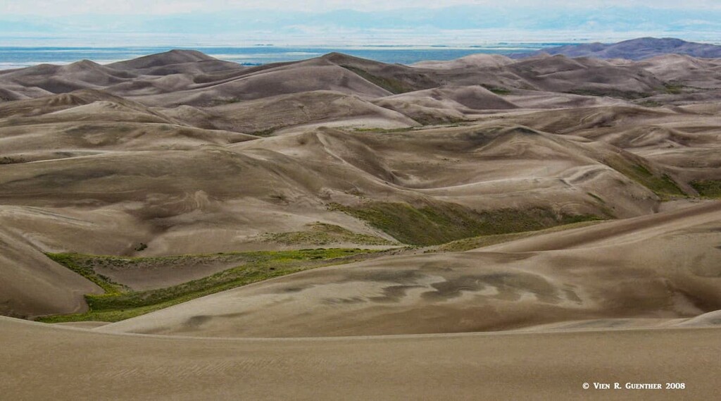
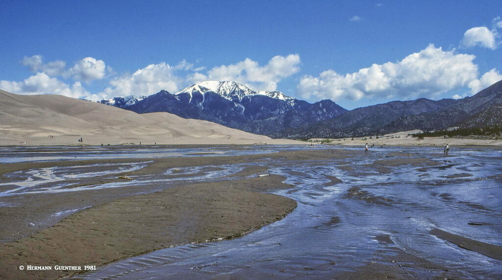
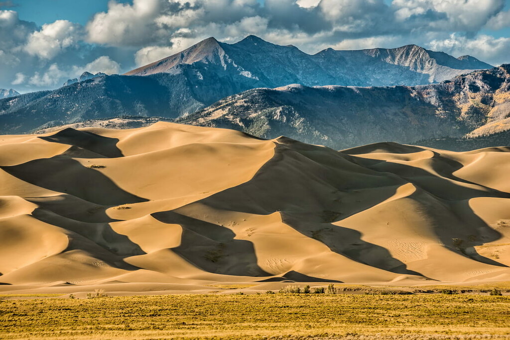
The entire county has an area of 723 square miles and a population of 15,445 (according to the 2010 census), which gives it a population density of 21 persons per square mile. Besides the city of Alamosa, the county has only one other town – Hooper, which has about 100 residents. But with Alamosa situated right at the crossroads of two major national highways, this can be a fairly busy place. Tourists will flock here for recreation, though not overwhelmingly so. The main attraction is the Great Sand Dunes National Park and Preserve. With the tallest dunes in North America, reaching up to 750 feet high, this is one place in the county not to be missed. The greater part of the dune field lies in the adjacent Saguache County, but the only real visitor access is in the south from Alamosa County, and here is where most visitors will play in the dunes. There is a visitor center and a campground near the entrance to the park.

Sitting at the base of the mighty Sangre de Cristo Mountains, these dunes have an impressive backdrop that not too many other dunes in the world have. Yet most of the really high mountains are in Saguache County to the north, while the truly towering peaks in Alamosa County are well south of the sand dunes. These mountains, part of the Sierra Blanca Massif, are arguably the second major recreation venue in the county. Remembering that this country is mostly agricultural, it follows that there are very few named mountains here – in fact only 11 named peaks, but they offer lots of “bang for the buck” as the saying goes. The highest and most prominent mountain is Blanca Peak – fourth highest mountain in Colorado as well as in the entire Rocky Mountains of North America. It is one of only three ultra-prominent mountains in the state (the other two are Mount Elbert and Pikes Peak). Included in this small collection of named mountains are two more fourteeners (Ellingwood Point and Little Bear Peak) as well as two thirteeners. The three fourteeners sit on county boundaries such that they are shared with adjacent counties.

There are really only two places to go hiking in Alamosa County – in and near the Great Sand Dunes and in the Sierra Blanca Massif. Some of these trails will be in either the Great Sand Dunes Wilderness or the Sangre de Cristo Wilderness. Some trails will penetrate the Rio Grande National Forest as well. Within the sand dune field, where most visitors will try to hike, there are no maintained trails. Here, you just wander where you want, but be sure to not go so far as to get lost, which is entirely possible in the interior parts of the dune field. Another note of caution – you don’t want to be wandering on the tops of dunes during a thunderstorm. Your risk of getting struck is significant.

Star Dune and High Dune – Surprisingly, these two landmarks are included in the list of the 11 named mountains in Alamosa County. They are hard to distinguish since they are hardly mountains, but if you just aim for a couple of piles of sand that look like they are the highest, you will most likely have “climbed” them. Try to follow the ridges where you can. If you try to go up the sides of the dunes, every step forward will likely result in a step backward. We have done it, so we know. Of course, going down the steep sides can be lots of fun. If you wear any kind of shoes or hiking boots, they will fill up with sand within the first few steps. It’s best and most fun to go barefoot – but beware, in summer the sand gets so hot that you can burn your feet. Also, in order to approach the dune field from the parking area, you need to cross the Medano Creek. You definitely want to be barefoot for this, but that is usually the case only in the spring and early summer when the snowmelt flows down from the mountains. Late summer or fall, there may not be any water flowing here. When it does flow, it is not much more than ankle deep, but it can be several hundred feet wide! And it will be cold.

Sand Ramp Trail – This 9.5-mile trail begins at the visitor center and follows around the northeast perimeter of the dune field to its northern end. It is said to be quite sandy in places and really does not have a defined destination. The trail affords good views of the perimeter dunes and even well into the dune field. Most of the length of this trail lies within the National Park as well as in the Great Sand Dunes Wilderness.
Mosca Pass Trail – This moderate 2.7-mile (one-way) trail, which begins at the visitor center, gains 1,460 feet in elevation on its way to Mosca Pass on the crest of the divide. Here it joins Huerfano County Road 583 from the east. At the right time of year, this hike is said to have some wonderful wildflowers, accompanied by countless vicious mosquitoes. Probably best to go in autumn when the huge aspen groves change their colors and the mosquitoes have gone south for the winter. (Just kidding, they don’t actually migrate south - they just die off.) The views from the trail are not particularly dramatic, though from the lower parts, one can get a different perspective of the dunes down below.
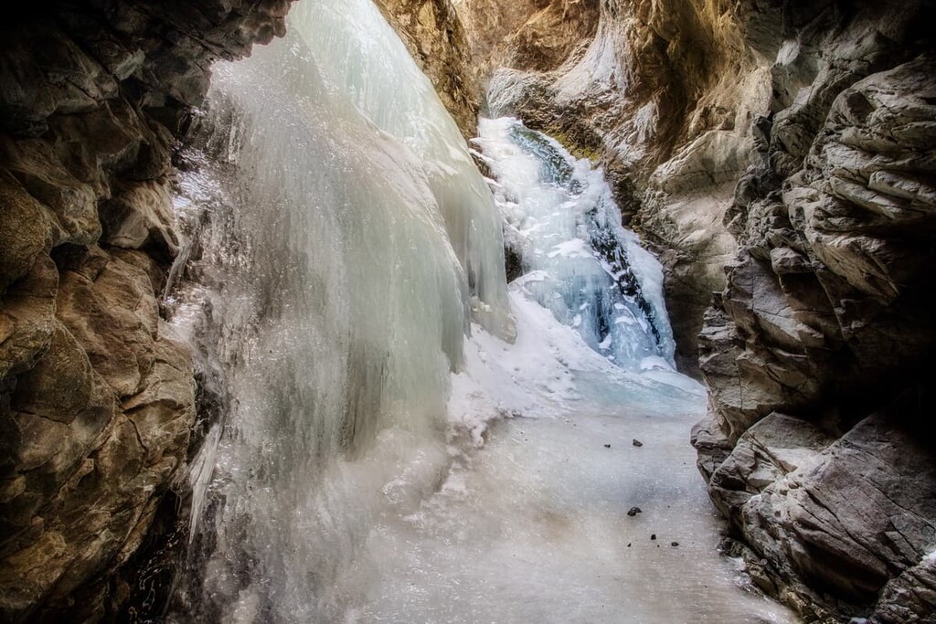
Zapata Falls Trailhead – This popular trailhead can be reached via a gravel road, suitable for passenger cars, that is located off SH-150 just five miles south of the Great Sand Dunes visitor center. The trailhead is near the Zapata Falls Campground, and the hike to the falls is only one mile round-trip – in other words easy. However, when the falls are frozen, it becomes an icy adventure since the falls cannot be seen from the trail. A longer hike is possible to South Zapata Lake, this one being more difficult due to its 10-mile round-trip length and 3,200 feet of elevation gain. A very scenic and moderately trafficked hike that is especially enjoyable in the early autumn when the aspen trees change colors. This trail can also be used for climbing the peaks of the Sierra Blanca Massif (see below), but that is extremely long and punishing to even the most fit climbers.

This group of fourteeners, dominated by the ultra-prominent Blanca Peak, is located approximately 20 miles east-northeast of the city of Alamosa. Three of these peaks are in Alamosa County although they all sit on county boundaries and are thus shared by adjacent counties. These mountains, some of the most magnificent in Colorado, are difficult to approach, in part due to the fact that much of the land on the south and southeast side of the massif is private property. There are in fact only two viable trailheads to access these peaks - one of which is on the Alamosa County side of the range. These mountains, of which Blanca Peak is the tallest and one of only three ultra-prominent peaks in Colorado, are truly spectacular. They dominate the views in the southern part of the San Luis Valley. These three fourteeners - Blanca Peak, Little Bear Peak, and Ellingwood Point - are best left to the experts.

Lake Como Trailhead - This is the main staging point for climbs of Blanca Peak, Little Bear Peak and Ellingwood Point. It is about 20 miles from the city of Alamosa and at 8,000 feet elevation, it is the lowest trailhead in Colorado for climbing fourteeners. It is theoretically possible to drive all the way to Lake Como at 11,750 feet, another five miles up the road, but that involves negotiating the most challenging four-wheel drive road in Colorado, which is only possible with specially modified vehicles. Most drivers stop at the lower location, though some continue on up to 10,000 feet and park somewhere along the road, depending on their comfort level. At any rate, those wishing to climb the high peaks will likely camp above Lake Como - in a deep basin defined by Holbrook Creek - before making their ascent. This then is the primary staging point for climbing these peaks. Casual hikers don't usually come up here, although Lake Como is very scenic. There are several additional lakes further up in this basin - the two Blue Lakes and Crater Lake.The only trail to Lake Como is the jeep road and it is very unpleasant to hike.

If you are into camping, you are in luck since there are several campgrounds in Alamosa County, including one in the Great Sand Dunes National Park and one near the Zapata Falls Trailhead. If you desire less spartan accommodations, you only have one choice within county limits, and not much more nearby. The city of Alamosa is your most logical choice.
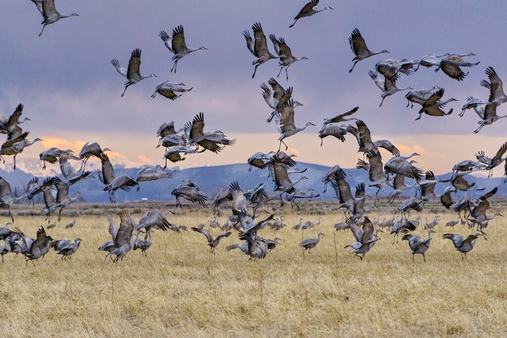
In the middle of the immense San Luis Valley, and close to the center of Alamosa County, sits the city of Alamosa. With a population of less than 9,000, this is by far the largest town anywhere close to the attractions found in this county. Despite its relatively small size, the town offers almost any amenity that a visitor would require for an extended stay to explore these attractions - accommodations, restaurants, hospital, golf course, shopping and even an airport with regional scheduled airline service, including to Denver. This is the place to stay if hiking access to the western approaches to the Sangre de Cristos is desired. Visitors to the Great Sand Dunes National Park are very likely to base themselves in Alamosa for a multi-day visit. This is also the place I would choose to stay for witnessing the twice-yearly migration of the Sandhill Cranes, many of which stop for “fuel” on their migration from New Mexico to the northern United States and Canada. The barley fields provide millions of fallen grains that these birds really love.


Explore Alamosa County with the PeakVisor 3D Map and identify its summits.