Showery Tor is a rocky outcrop on a ridge-top approximately 0.6 kilometres (0.37 mi) north of the Rough Tor summit, near Camelford on Bodmin Moor in Cornwall. It is notable for its rock formations and prehistoric monuments.
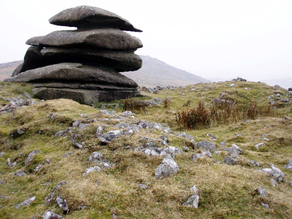
The Tor is a prominent landmark for a wide area. It consists of a natural outcrop enveloped by a giant man-made ring cairn and was thought to have been a religious focal point. Craig Weatherhill in "Cornovia: Ancient Sites of Cornwall & Scilly" calls it "A natural formation of weathered granite, 5 metres (16 ft) high ...is surrounded by a massive ring cairn of piled stone 30 metres (98 ft) in diameter and up to 1.2 metres (3.9 ft) high. The natural formation was evidently intended as a focal point. No excavations have been recorded at this site, so it is not known how many, if any, burials were associated with this presumably Neolithic or Bronze Age site" Christopher Tilley has estimated the height of the cairn on which the outcrop stands to be 3 metres (9.8 ft). The granite outcrop is reminiscent of the Cheesewring and made of individual blocks on underlying outcrops formed by erosion along horizontal fractures in the granitic mass. Aerial photography has revealed more about the layout of the structures on Showery Tor and it stands out as the only natural formation to have been used in this way by the cairn designers.
There's a trail leading to the summit.
By elevation Showery Tor is
# 8 out of 94 in Cornwall AONB # 8 out of 161 in Cornwall
We use GPS information embedded into the photo when it is available.
3D mountains overlay
Adjust mountain panorama to perfectly match your photos because recorded by camera photo position might be imprecise.
Move tool
Rotate tool
Zoom
More customization
Choose which peak labels should make into the final photo and what photo title should be.
Next
Photo Location
Satellitte
Flat map
Relief map
Latitude
Longitude
Altitude
OR
Latitude
°'''
Longitude
°'''
Apply
Register Peak
Peak Name
Latitude
Longitude
Altitude
Register
Teleport
PeakVisor
This 3D model of Sagarmatha National Park in Nepal was made using the PeakVisor app topographic data. The mobile app features higher precision models worldwide, more topographic details, and works offline. Download PeakVisor maps today.
Download OBJ model
PeakVisor
The download should start shortly. If you find it useful please consider supporting the PeakVisor app.
PeakVisor for iOS and Android
Be a superhero of outdoor navigation with state-of-the-art 3D maps and mountain identification in the palm of your hand!