Rock Art 3D

There’s a concentration of prehistoric rock art around Castletownshend and I am currently writing a paper about that for the next issue of the Journal of the Skibbereen and District Historical Society. There are seven individual pieces of rock art: as part of the research I recently visited the one stone I hadn’t seen yet. Fortunately, we had the company and assistance of Conor Buckley of Gormú Adventures (been on one of his marvellous walks yet? If not, try this one, or this one or this one.) who, as a native of the area, knows everyone and introduced us to the landowner, the genial Bill O’Driscoll.

The townland is Farrandeligeen – isn’t that a wonderful name? A dealg is a spine or thorn or prickle, and therefore a deilgín is a small one of those. So it can be translated as the Land of the Thorns, which can be blackberries or blackthorns – and this being West Cork, probably both. An old saying is Is beag an dealga dhéanfadh braon – the tiniest thorn can cause big problems. Thorn in a hiking boot, anyone?

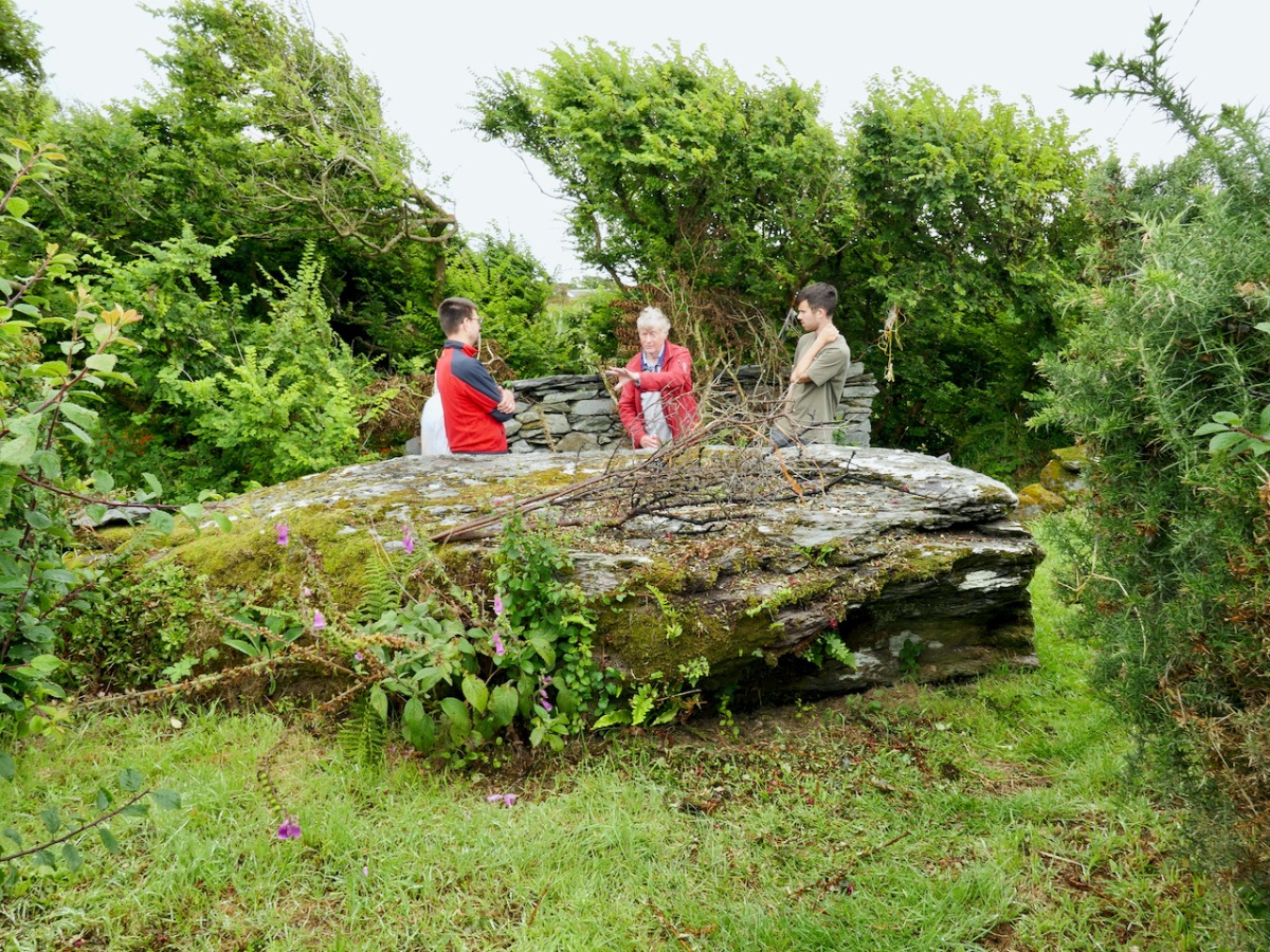
The land lived up to its name. Bill took us to where he knew the rock art was, and that’s when we encountered the deligeen bit. Fortunately he had a stout fork with him, and took to hacking and bashing his way through the thorns, while we stood back and offered encouragement. The first place proved unfruitful and he moved a few metres away and soon struck gold. Among the brambles, earth, gorse and general undergrowth there was a hint of something white. This turned out to be a bag filled with stones – the very bag he had put there to remind him that this is where the rock art was – but so many years ago that it had slipped his mind until now.

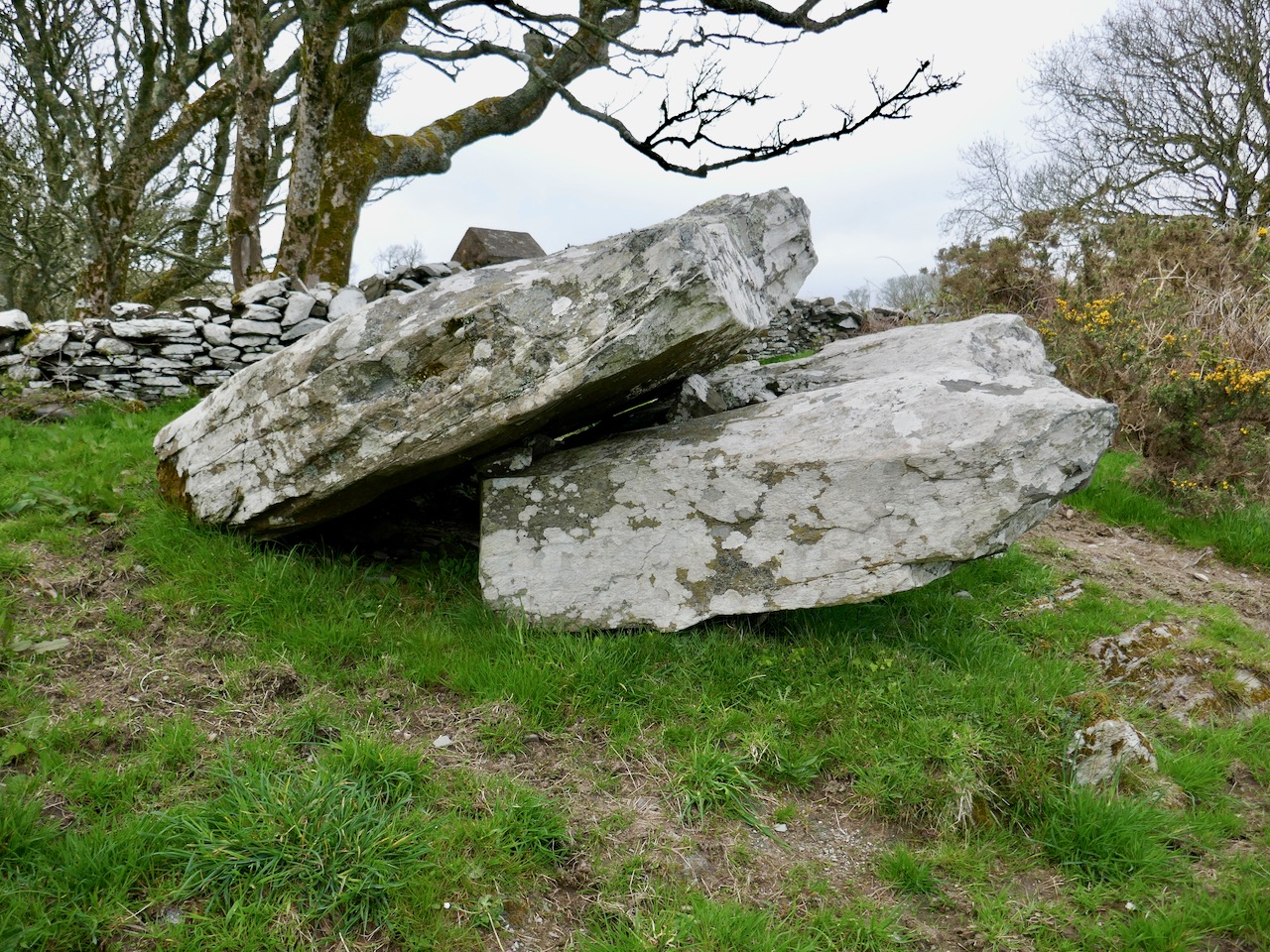
And so the stone gradually came into view until I could finally get down to clearing it off with my gloves. (I was sorry I hadn’t brought the red socks.) This stone is already in the National Monuments Records as a ‘Cupmarked Stone’ (CO151-013) and is described as having ‘at least ten cupmarks’. Bill told us that his father had said he remembered the stone standing upright – it had fallen to its present position flat on the ground since his father’s time.

For more on what a cupmarked stone is, and how it fits in to the general category of ‘Rock Art’, see my post The Complex Cupmark. For now, quoting from that post:

The cupmark is the most basic and numerous element or motif of rock art in Ireland and elsewhere. In the examples labelled rock art in County Cork, they occur with other motifs, principally concentric rings, sometimes with radial grooves, and a variety of curved or straight lines. They can be incorporated within a motif (as in cup-and-ring marks, rosettes, or where enclosed by lines) or they may be scattered, seemingly randomly, over the surface of the rock, between and among the other motifs. 

. . . patterns of straight lines, or of rough circles or semi-circles, can be made out in several of the stones we have recorded to date.

Rock art is widespread across the Atlantic coast of Europe and is believed to date from the Neolithic, about 5,000 years ago. The cupmark as a motif, however, continued well into the Bronze Age, since we find it on wedge tombs and boulder burials. We do not know what the significance of the cupmark is, but it must have held a special meaning to the carvers since it persisted over time and space.

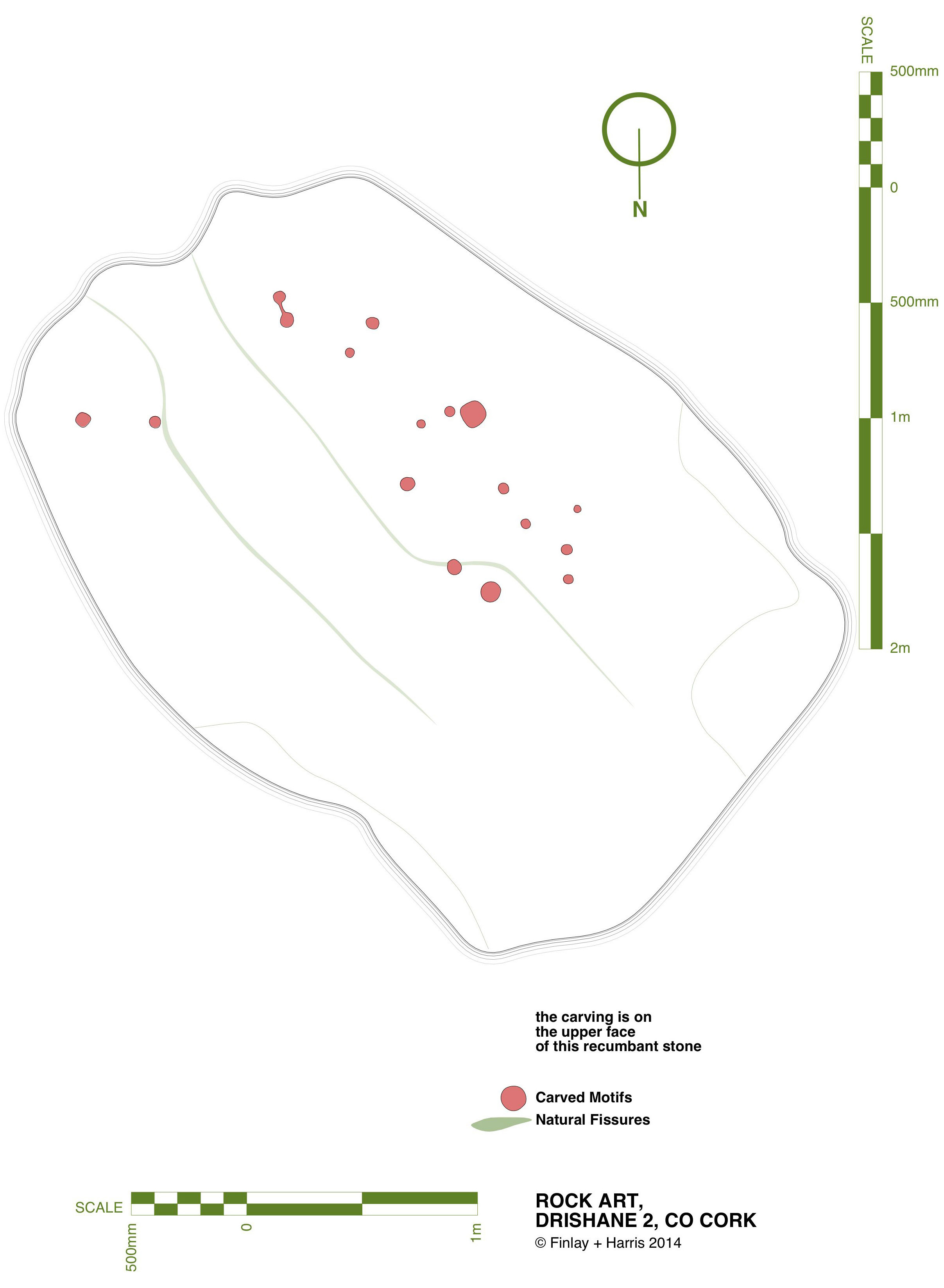
We got the rock cleared enough to identify the cupmarks and I put a button in each one to make sure it showed up – sorry, those are not gold coins. Some of the cupmarks are tiny. You can look at the cupmarks as a random scatter, or as in the quote above, you can see two groups, in which a cupmark is surrounded by a semicircle of four others. 

It was hard to get the rock clean enough to see detail so I decided to carry out a photogrammetric survey, the object of which is to end up with a 3D image from 2D photographs. That involves taking LOTS of photos (in this case, 100) of the stone, working my way systematically across the surface of the stone at three different levels, keeping the camera settings consistent.
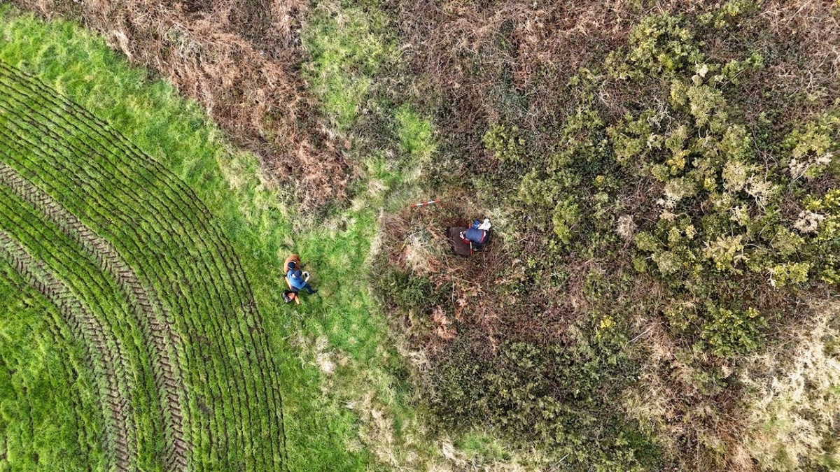
Conor had his drone with him – a new experience for us! He took photos and videos of the stone in its general location, capturing me doing the photogrammetry and also a good indication of the amount of undergrowth that had to be cleared out of the way before the rock came into view. (Thank you, Bill!)

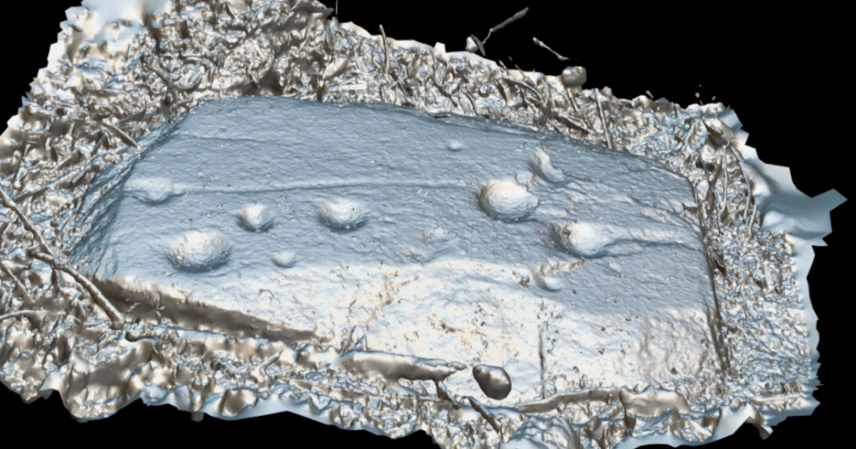
I sent the photographs off to UCC, to the Department of Archaeology, where Nick Hogan generously processed them for me, using the Department’s specialised software. The results are fascinating!

First of all, it looks like there are more than just cupmarks on this rock. A long line stretches from the far left (in this image) cupmark to the right hand grouping. There is a hint of a circle around the bottom left cupmark. The three large cupmarks in the right grouping appear to be conjoined, and there is a line from from the far right cupmark to the end of the stone.

You can view the render in what is called Matcap, which creates it in a metallic view (above and below). On a grey day with no shadows, and still lots of mud on the stone, none of this was obvious to the naked eye. There is a possibility that these new elements, rather than being carved, are natural contours in the rock itself. We haven’t had time yet to go back and check this out more carefully, but we will have to do so – and update this post! If indeed the lines turn out to be carved, that fact will elevate the rock from a Cupmarked Stone to Rock Art. Watch this space.

If you’d like to see the 3D render for yourself and have fun turning it this way and that, you can click here. Let me know if you spot anything else! It was good to be out in the field again after a long winter of cold wet weather. It was great to have Conor and his drone along and to meet Bill, who is committed to keeping safe this precious part of our heritage.

Rock Art and Red Socks

(Mizen Magic 26: Balteen)

What do red socks have to do with rock art?  Well, nothing really, but they turned out to be surprisingly useful this week.

It’s been ages since we talked about rock art, hasn’t it? Thinking about that, I decided to do some tidying up in our blog and I have created a special page for Rock Art, and another one for Mizen Magic, since this post also fits into the Mizen Magic series. 

Robert and I set off to hunt down rock art we haven’t yet seen on the Mizen. The National Monuments site contains two records for Cupmarked Stones in the townland of Balteen, and both proved easy to find. (If you can’t remember what a Cupmarked Stone is, take a look at this post before reading on.) The first is along the road that leads from Barley Cove to the North Side. That’s my butt marking the location of the rock, above.

It’s built into the bank and we might not have been as quick to spot it as we were unless somebody else had already found it and cleared away some of the overgrowth – I suspect Rock Art Kerry, AKA Aoibheann Lambe had been there before us, perhaps a couple of years ago. We usually remember to bring a soft brush with us for a gentle cleaning of the rock surface (lots of moss on this one) but we had forgotten this time. The red socks came to the rescue.

This is a lovely example of a cupmarked stone – although it’s possible there is more on it than cupmarks only. The central cupmark appears to have some carving around it that helps to mark it out and elevate it – not a complete circle but an arc that may end in an expanded finial. We have sent the photos off to UCC for a 3D rendering and this may clarify this aspect of the carving. Here’s a short video – see what you think about that arc.

Meanwhile, since it’s hard to make out what’s in the surface of a grey rock on a grey day, clever Robert has made a scaled drawing of it. We know that cupmarked stones like this can date anywhere from the Neolithic (about 5,000 years ago) up to the Bronze Age (ended about 2,500 years ago), and that the cupmarks were probably made by picking or bashing them out with a stone cobble, but we don’t know why they were done, or what meaning the cupmark itself may carry.

We also don’t know if this one is in its original position, but it’s likely that it is not. It is currently incorporated into the bank at the side of the road, leading us to suspect that it was found in the vicinity and built into the wall to give it a place where it would be visible to all passers-by.

The second one (above) was a surprise! First of all, it’s enormous! It looks like it may have been a capstone for a large structure, or perhaps a boulder burial. However, it’s difficult to determine if there is anything underneath and it may well be a glacial erratic that simply ended up here. This one is in the same townland but it’s on private property, so we are not pinpointing it on a map, at the request of the owners – but they are happy to give permission to see the stone and they welcomed us to take photos and tell them a little about rock art in general. There are nine cupmarks, from large to small and some appear to be arranged in a rough semi-circle – something we have observed on other cupmarked stones.

I am trying something a little new with this post – doing short videos to see if this helps to convey more than a photograph might. I’d be interested in your feedback on this. Note: You may have to play the videos on YouTube – sorry if this aspect isn’t working right for everyone!

Just when you think you have seen all the Mizen has to offer, it reveals yet more of its secrets!

Experimental Archaeology – Oliver’s Cupmark

As a student of rock art I am often asked whether a cupmark, the central motif of all Irish rock art, could be just idle ‘doodling’. In response I have usually asserted that making a cupmark is quite a lot of work and therefore unlikely to be the result of simply whiling away time. But I must admit I based that answer on my own guesswork about of the time and difficulty involved, rather than on solid evidence. Well, no more! The scientific evidence is in – read on to see what we found.

Before he started – Oliver chose a piece of local sandstone and a variety of water-rolled cobbles as picks

First of all, let’s recap what a cupmark actually is. It’s a semi-hemispherical indentation on a rock surface which has been made by a human in the past. In Ireland it’s the most common motif found in prehistoric rock art, often on its own, and also associated with one or more concentric rings, lines extending from the cupmark through the rings, and other lines and grids. It’s usually circular in outline, sometimes perfectly so and sometimes rough and approximate. For a thorough discussion of Irish cupmarked stones, take a look at our post The Complex Cupmark, which has lots of illustrations of cupmarks, both on their own and with cup-and-ring marks. It’s a good introduction to what we are talking about and where they are sited in the Irish landscape.

Oliver found that the first part was the hardest – almost, he said, as if there was a skin you had to break through

Grand so – now you know all about cupmarks except for how, really, they were made. Our friend Oliver Nares became interested in this topic having read our blog posts, and decided that this question should be answered once and for all. In doing so, he has provided a real service to science.

Once through the ‘skin’ things went a little faster and the hammering action raised lots of dust. In some ethnographic studies of cultures that carve cupmarks it appeared that the dust was one of the desired outcomes and played a part in whatever rituals were involved

Believing that he should replicate as closely as possible local conditions, Oliver selected a piece of local sandstone as his base. The technique used to carve is often described as ‘picking’ – that is, repeated taps on the surface of the rock by a stone ‘pick’. No metal was used: the cupmark tradition, although it persisted in time well into the Bronze Age, started in the Neolithic before the invention of metal tools. Copper or bronze would not have been strong enough anyway.

Oliver started with a quartz pick, reasoning that, as one of the hardest local minerals, this would be the ideal stone. However, he soon realised that the quartz stones he could find were not large enough to make a serious impact on the sandstone surface.

He gathered a variety of water-rolled cobbles from a local beach and worked away until they became too chipped, or until they broke. In this way he went through at least a dozen cobbles, perhaps as many as twenty.

On one visit to watch progress I took a turn. What I found hard was maintaining the round shape – as you can see my hammering was turning Oliver’s lovely circle into an egg-shape

A pick is generally a pointed tool – a bit like a hammer but with a pointed tip that allows a geologist, say, to split rock to take samples. Modern picks are made of very hard steel. In practice, it is almost impossible to find a stone that will mirror the pointy-ness and the hardness of a steel pick. Oliver found that hammering or bashing with a cobble was actually the only way he could make headway on carving out the cupmark. Perhaps picking, in fact, is not quite the right was to describe the technique. 

Once the cupmark was as deep and round as he wished, his next step was to smoothen the inside. We have noted this as a feature of cupmarks – when you run your fingers around the inside they do feel more smooth than rough. In fact, a rough surface is often an indication that the ‘cupmark’ is actually a naturally occurring geological anomaly or solution pitting rather than the product of human labour.

At first Oliver used only water to grind away at the surface (above), but soon added beach sand (below) and saw an immediate improvement. His finished product – a cupmark 12cm across and 3.5 com deep – was nice and smooth inside. In terms of size, this cupmark falls well within the normal range of variation in the cupmarks we have seen. 

So, how much time did this actually take, and how much work was it? Oliver estimates that he put between 20 and 25 hours into making this cupmark. Despite being tall and strong, he couldn’t work on it for too long at a stretch because, as is obvious in the videos, repetitive strain and muscle damage was a real hazard.

The other thing that smoothing did was bring out the dark colour of the rock under the surface

What Oliver has shown is that nobody would carve a cupmark unless they were deeply motivated to do so. It must have been an important activity associated with some aspect of the culture that required the kind of labour involved. Perhaps long practice enabled prehistoric carvers to make a cupmark in less than the time that Oliver took but there’s no denying that even for an expert this is a significant undertaking.

Thank you, Oliver, for all that effort! And thank you too for the cupmarked stone itself, now occupying a space outside our door. it looks great – but more than that it is a constant reminder of both your generous donation of your time in the cause of science and the age-old tradition of cupmark carving and the mysteries that lie at its heart.

Inish Beg Estate: Ancient Woods and New Discoveries

Craving a woodland walk, we took ourselves to Inish Beg this week – and found a lot more than bluebells!

This is a cillin, down beside the river. There are lots of stories associated with it

Inish Beg abounds in both the wild and the tame. That’s not such an easy balance to maintain and it’s a real tribute to the team on the ground that manages and nurtures the estate. Mostly, of course, it’s down to the vision and hard work of Paul and Georgiana Keane who bought the place in 1997 when it was crumbling and neglected. The house, Georgie told us, was close to collapse and had to be completely re-done – new roof, plumbing, electrics and a complete re-furbishment. It’s hard to believe now, when you see the beautiful place it has become.

Paul and Georgie run it now as a hotel and wedding venue and it is totally set up for it. In fact it must be one of the most romantic venues in Ireland, ideally situated on an island on the Ilen River, accessible by an old stone bridge. It was originally O’Driscoll territory, but owned by the McCarthy family. When James Morrogh inherited it from a McCarthy relative in the 1830s he changed the family name to McCarthy Morragh – such stipulations were not unusual then.

In the 1890s the family built the grand house, and it is this house that is associated with its most famous inhabitant, Kay Summersby. A noted beauty, she was Eisenhower’s secretary in London during the war, and may (or may not) have had an affair with him.

She describes her early life at Inish Beg thus:

Our home, Inish Beg, was a somewhat run-down estate on a small but lovely emerald island in a river in County Cork. Our favourite pastime (I had a brother and three sisters) was to sail down that river four miles, to the Atlantic. There was a succession of governesses, hunts, spatting parents, riding in the fields and along the long avenue fringed with old trees . . . the usual pattern of life in that obsolete world.

The ‘usual pattern’ for some, perhaps – to me it sounds like a life of breathtaking privilege. However, like many such estates, it became difficult to sustain and by time the Keanes took it over it desperately needed their infusion of enthusiasm and capital. And what a magnificent job they have done with not only the house but the grounds as well.

There’s a walled garden (above) that’s full of organic goodies for the estate kitchens, and also features an indoor swimming pool! Tony O’Mahony, the head gardener, practises an organic philosophy and does not feel the need to eliminate wildness from the garden, which results in a delightful mix of plant life.

But we were here mainly for the woodland walks and we were certainly not disappointed. You could spend several hours wandering the trails here and right now the undergrowth is glorious. Bluebells were in abundance along with every wildflower that contributes to that colourful spring carpet that is so dear to our senses.

There are trails for the kids – pirates and a wildlife search are part of the system, as well as little fairy houses here and there.

There are lovely views (above) across the Ilen to the ruined church at Aughadown – burial place of the Tonsons that I wrote about in New Court Bridge – a Hidden Wonder. Surprisingly, beyond the church, you can see Mount Gabriel. I mention this because of its significance with our next find – a previously unrecorded cupmarked stone!

Regular readers know of our involvement with Prehistoric Rock Art – Neolithic or Bronze Age carvings on open air boulders and outcrops. The cupmark is the basic motif of all Irish Rock Art – a semi-spherical cup-shaped hollow (see more about Rock Art here and here and specifically about cupmarks here). Robert has an amazing eye for slight differences in rock surfaces and has developed a habit of examining every stone we come across for cupmarks. This time he struck gold! At least four cupmarks on the back of a stone along one of the trails.

We like to warn people that rock art can be a little underwhelming. I know these cupmarks don’t look like much, but they were probably carved several thousand years ago as part of a ritual we now know nothing about

The stone has been moved there from somewhere on the estate and the Keanes will try to track down where this was. It’s always important to see a rock like this in its context, of corse, but we are also curious to know if Mount Gabriel was visible from the location, as it is from so many of our West Cork Rock Art sites. We will be returning to do a proper record and see if we can add more information to the story before we send it in to be included in the National Monuments database.

There’s also a boulder burial on the estate, visible as you are leaving. It’s a pretty tumbledown affair, but still recognisable, and we found cupmarks on the capstone too. These may be already recorded, but we will let National Monuments know in case they aren’t.

Fabulous woodland walks, my fill of wildflowers, lovely vistas across the Ilen – and a new archaeological find. Too much excitement for one day!

A Walk on Sherkin Island

You can’t live in West Cork without constantly being aware of the sea – it’s all around us. And the offshore islands are always in our view as we look across Roaringwater Bay. It’s easy to get to the inhabited ones: there are good ferry services that run year round, although they can be hampered by winter storms. In this picture – above – the Cape Clear Ferry is leaving Baltimore, while the Sherkin Ferry is arriving to collect passengers for that island, including us: on a whim we went across on a wonderful warm September afternoon.

It’s a short sea voyage to Sherkin – all of 15 minutes! But it’s always exciting to be on the water. That’s the lighthouse on Sherkin in the picture above: it was built in 1885 of cast-iron construction and is now fully automated, as are all of Ireland’s lighthouses today.

We did have an aim – to find a piece of Rock Art that may be the earliest physical evidence of human occupation on the island. It’s a cupmarked stone in the townland of Kilmoon, overlooking Kinish Harbour. It was a fair walk to the west, over deserted roads and through fields. After a bit of backtracking we managed to find the stone, well weathered but with its markings still visible. It is situated with panoramic views all the way round, taking in the peaks of Mount Gabriel, Mount Corrin and Mount Kidd on the mainland: surely it must have been placed with those views in mind?

This picture shows the cupmarked stone in its present setting, just inside a private garden (if you go, please make sure you seek permission from the owners of the house!), while the one above shows the panoramic distant view which the stone commands.

Here is the surface of the stone which is heavily blotched with lichen, but it is possible to make out the well defined cupmarks: there are 14 in all. If you want to find out more about cupmarked stones and how they compare with Rock Art in general, we wrote this post a while ago. It sparked off a whole lot of debate (have a look at the comments at the end of that post) – and there is still much to be discovered in a history that may go back 5,000 years.

Our main mission was accomplished, but we couldn’t resist taking in some other historical sites while on the island. Firstly, we had a good look at the Franciscan friary – situated in the townland of Farranacoush – which has a colourful history. Here is a description from the current Irish Franciscans site:

. . . Permission for this foundation was given by Rome to Finighin O’Driscoll in 1449, but it was not until just after 1462 that the Observant friars actually arrived. The friary became the traditional burial place of the O’Driscoll’s. In 1537 the citizens of Waterford burned the building in retaliation for acts of piracy by the O’Driscolls. The great bell of the friary was on display in Waterford as late as 1615. There is no evidence to suggest that the friars were disturbed by the events of the Reformation until the island was garrisoned by the English following the Battle of Kinsale. The friars soon returned and, except at the height of the Cromwellian persecu­tion, were active all during the seventeenth and well into the eighteenth centuries. The last friar, Fr Patrick Hayes, died soon after 1766 . . .

In the picture above – taken from the OPW information board – you can see the attacks of 1537 by ‘the citizens of Waterford’ on both the Friary (in the foreground) and the O’Driscoll stronghold of Dún na Long (beyond). The castle was subsequently partially rebuilt and was garrisoned by a Spanish force in 1601. It was then acquired and restored by the Becher family in 1655 and remained in their ownership until the late nineteenth century. We went to see what remains of the castle today.

Our visit to Sherkin only took an afternoon – albeit a golden one. There’s plenty more to see there – and other islands to be investigated. And an endless exploration of history to be had in the landscapes of West Cork.

Boyle’s Bealtaine: Rock Art, Ancient Festivals, and Archaeoastronomy

Bealtaine is one of the great ancient festival days, the one that heralds the beginning of the season of fertility in crops and animals. It marks the mid-point between the spring equinox and the summer solstice, making it a cross-quarter day, and this year it fell on May the 5th. For the non-Irish speakers out there, it’s not pronounced bell-tane, but byowl (to rhyme with owl, the bird) – tinnuh – Byowltinnuh. If you’re really keen on getting it right, you can listen to it here.

Things did not look promising as we arrived at the Giant’s Grave – cloud and fog

We devoted two posts recently to the subject of Boyle Somerville. The first was a post about his life and his pioneering work on what is now called archaeoastronomy, but which he called the new science of Orientation. The second was about a site that was close to his home in Castletownshend, Knockdrum Fort. In Boyle’s own article on Knockdrum (available online with a JStor subscription), he notes a particular orientation between two fallen galláns (or standing stones) on a slight prominence in the grounds of Drishane House, to Knockdrum Fort itself at sunset on Bealtaine in 1930.

Standing behind the Giant’s Grave, Knockdrum Fort is clearly visible on the horizon

On that day, he states, he stood on the fallen galláns and watched the sun set directly over Knockdrum Fort. Yesterday, we did the same thing. It was a nerve-wracking business as not only cloud cover but a constant drifting fog obscured the hills and we were not hopeful that we would be able to see anything at all. But Boyle was up there, looking down on us, and at the last minute the clouds parted and there was the sun, exactly where he said it would be, angling slowly down to the fort.

The sun lights up the Giant’s Grave, making the cupmarks on its surface more visible

Watching this descent was a real highlight of my life here in West Cork. First of all, it felt really special to be on the same spot as Boyle Somerville, 88 years later to the day, and verifying his sighting by recording the phenomenon with photographs and video. If anyone else has done it in the intervening years, we can find no record of it, but would love to hear about it.

Secondly, this is essentially a rock art story, rather than a stone fort story. As Boyle himself pointed out, the stone fort at Knockdrum is but one piece of evidence of a long and continuous use of this commanding site. There are two carved stones at Knockdrum, one outside the fort with cup-and-ring type carvings, and a cup-marked stone currently lying within it. Look back at Robert’s post to see photographs and drawings of these two stones. These examples of rock art are likely the oldest artefacts on the site, dating to between four and five thousand years ago. There is also a cross-inscribed slab, possibly indicating an Early Medieval use of the site for ecclesiastical purposes. The stone fort itself may have been a relatively recent period of occupation, marking it as the fortified residence of a high-status individual about a thousand years ago. Boyle felt it may even have been used for look-out and defensive purposes in the seventeenth century.


Robert’s 2014 drawing of the surface of the Giant’s Grave capstone with 17 cupmarks

But the fallen galláns, known locally as the Giant’s Grave, also have cupmarks, tying them to the rock art tradition. The upper surface of the top slab has 17 cupmarks. Boyle counted 19 and the National Monuments record has it as 12, showing how difficult it can be to accurately identify man-made marks on a rough and heavily-lichened surface.

The Giant’s Grave, or fallen galláns, from the west side

While Boyle described this monument as two fallen galláns, it is unclear whether the placement of the two stones, one on top of the other, is accidental or deliberate. If deliberate, then this may be another type of megalithic structure, perhaps similar to a boulder burial (or clochtogle, as he preferred to call them). The orientation, then, as observed by Boyle in 1930 and by us in 2018, is from this probably Late Neolithic or Bronze Age structure to the place where other other pieces of rock art originally stood. Intervisibility, or the visibility of one piece of rock art from another, is well established in the Irish rock art literature. While we have written before (see here and here) about orientation from a piece of rock art to horizon markers, we have never before recorded a specific orientation, involving a solar event on a calendrical day, between rock art sites. So, this is a first for us, and may be a first for Ireland.

This is the Gortbrack stone, on its stand in the Stone Corridor at University College, Cork (UCC). It came from the townland next to Knockdrum Fort

In fact, it is easy to forget that three other examples of rock art come from adjoining townlands because they are no longer in situ: one is in the grounds of Drishane House and two are in Cork City. Six pieces of rock art less than 3 kilometres apart make for a ‘concentration.’

Above, the rock art currently in the grounds of Drishane House, but originally from Farrandeligeen

The Drishane House stone came from Farrandeligeen, immediately west of Drishane townland. In the field notes kept by Boyle, and discovered by Dr Elizabeth Shee, he notes that the stone was originally built into the wall of an outhouse. . . but was brought to Drishane House by Colonel Somerville in about 1880, for safe keeping.

This is one side of the Bluid Stone (both sides are covered in cupmarks), which is housed at the Cork Public Museum

The other two pieces are from the townlands of Gortbrack, immediately to the west of Farrandau (the townland in which Knockdrum Fort is situated) and Bluid (either East or West) which is to the west of Gortbrack. Gortbrack is in the Stone Corridor at University College Cork, and the Bluid stone (an unusual two-sided example) is at the Cork Public Museum. Both had been in the possession of Boyle Somerville, and were presented to UCC after his death. They had been brought to him by local farmers who knew of his interest in such things. We can only lament that of the six separate examples of rock art known from this immediate vicinity, we can be reasonably confident that only one, the Giant’s Grave, is in its exact original location. Neither of the two pieces at Knockdrum Fort are precisely where they were found, but at least they do not seem to have been moved more than a few metres from their original situations.

There is scope for much more investigation of this intriguing group – we shall call it the ‘Boyle Somerville Rock Art Concentration’. But for now, let us once more raise a toast to Boyle, pioneering archaeoastronomer of West Cork.  His legacy lives on.