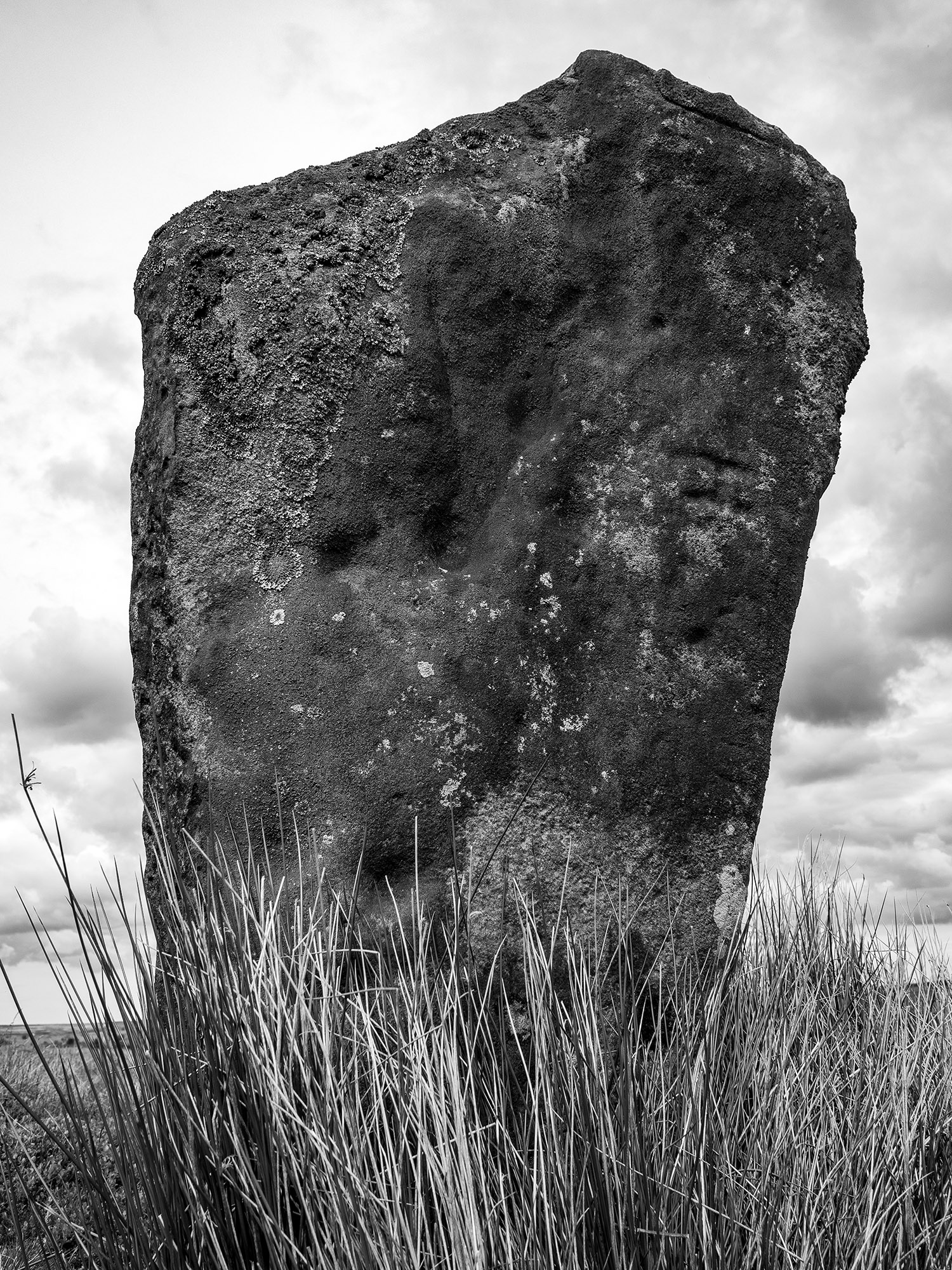
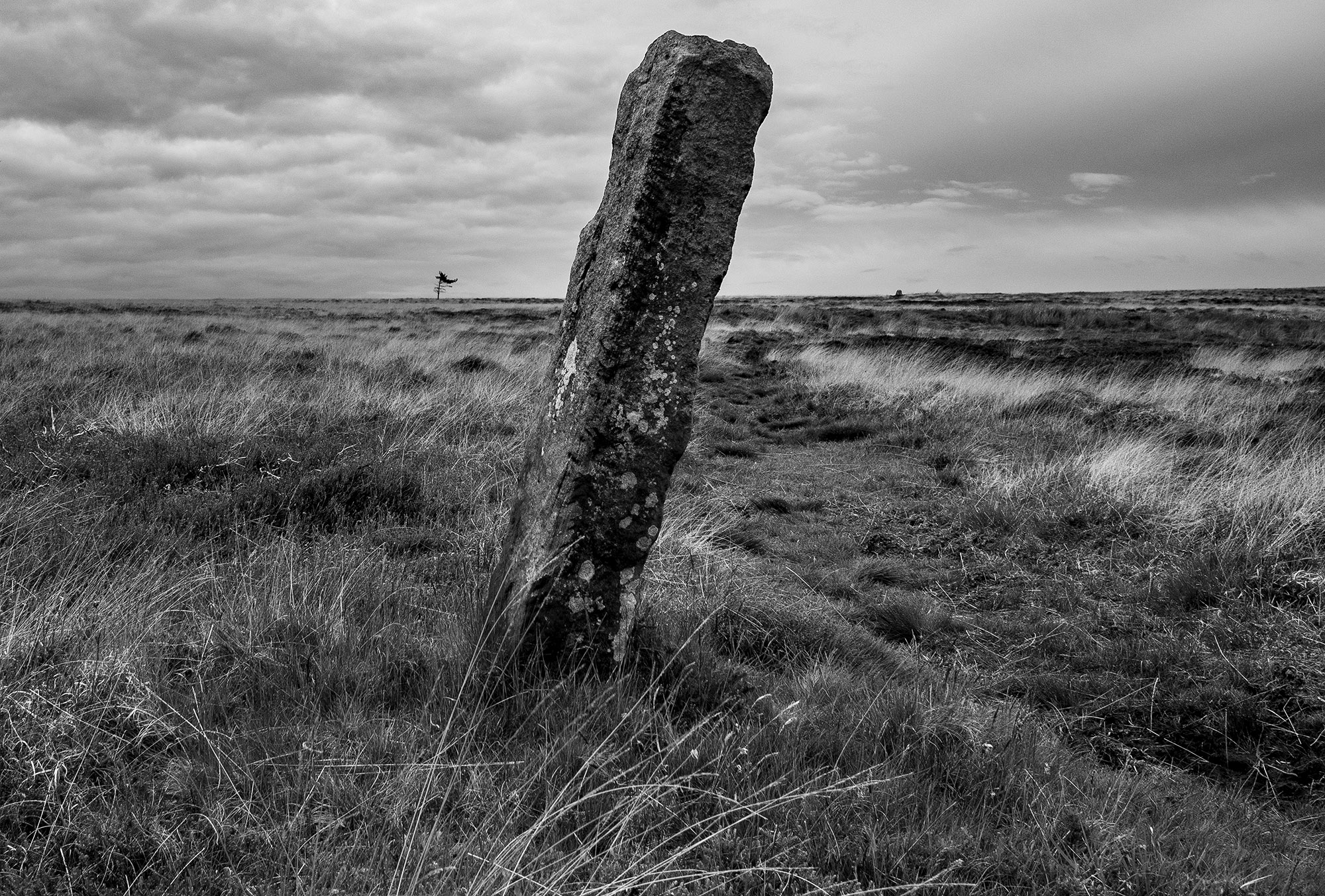
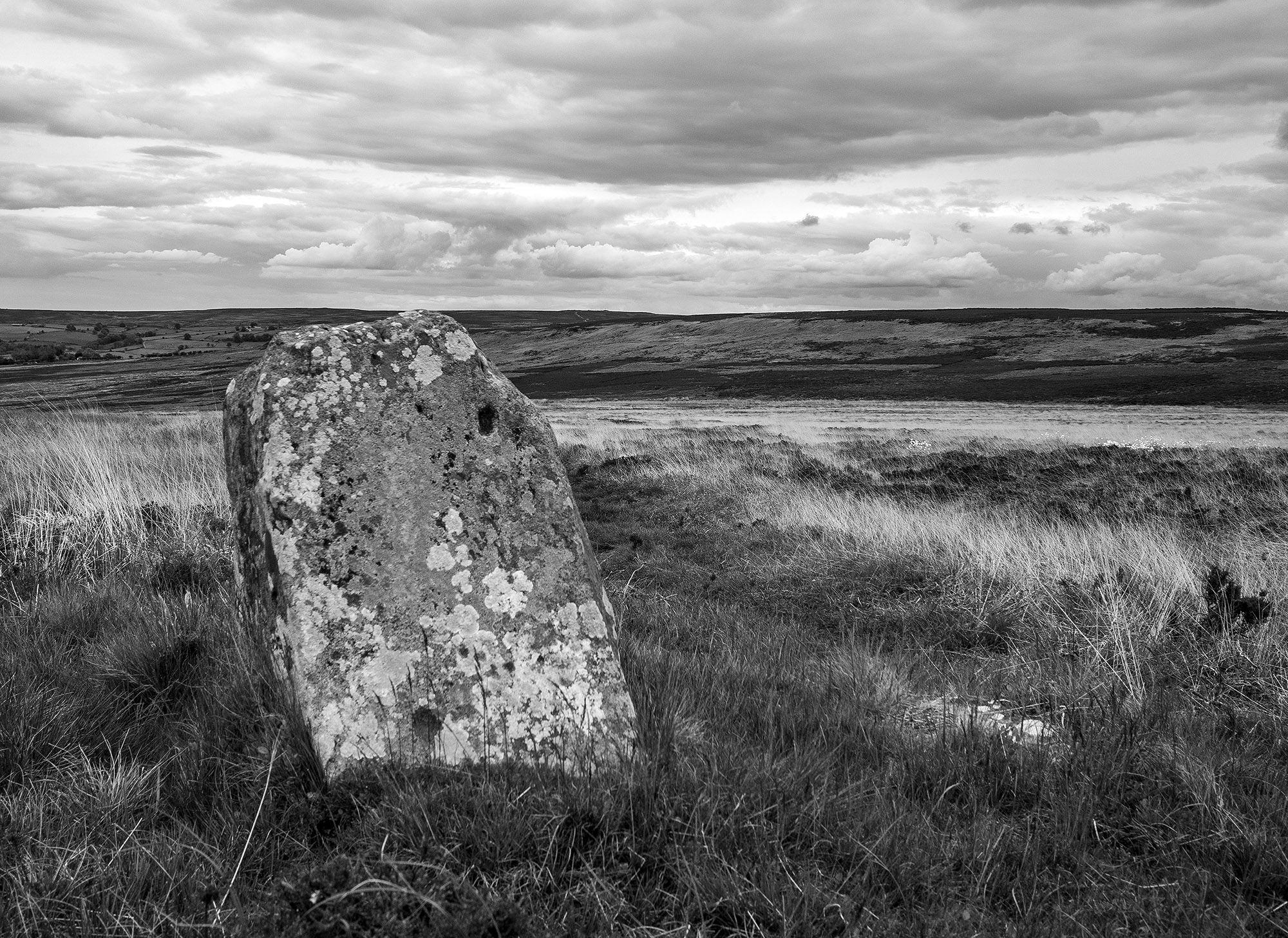
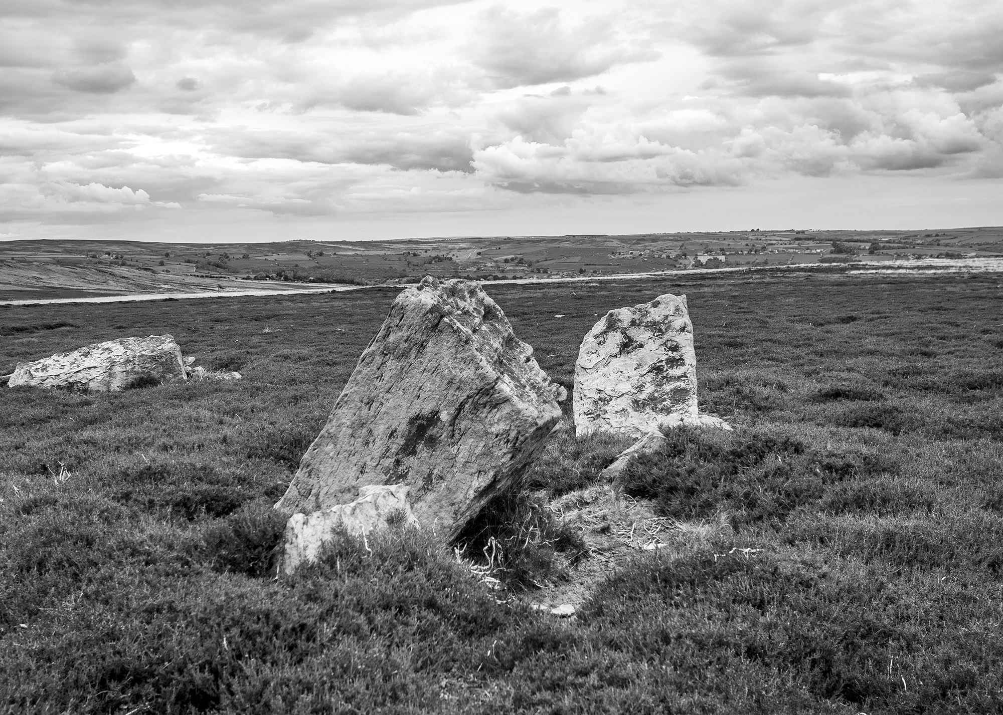
I took a trip over to Glaisdale to visit one on my favourite North York Moors standing stones. This rarely visited, tall, beautiful stone is one of a pair of upright stones located on Glaisdale Swang
Swang – a boggy stretch of land.
When I arrive at the stone I’m confronted by an anxious pheasant hen who starts running in circles around me, a tactic designed to distract me while her brood of chicks scatter for the shelter of the nearby heather.
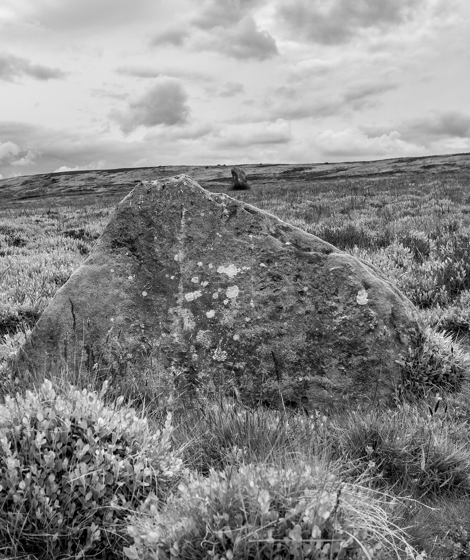
I can see another stone on the moor edge in the distance, I know that this will probably be a guide stone but probably isn’t good enough, I head for the higher ground. The ground is marshy, so I zig zag my way up the narrowing valley following the lush green carpet of bilberry which tends to grow on the better drained ground. Curlews and lapwings rise in alarm and noisily track my progress as I move from one birds territory to another. Towards the top of the swang, a large hare breaks cover.
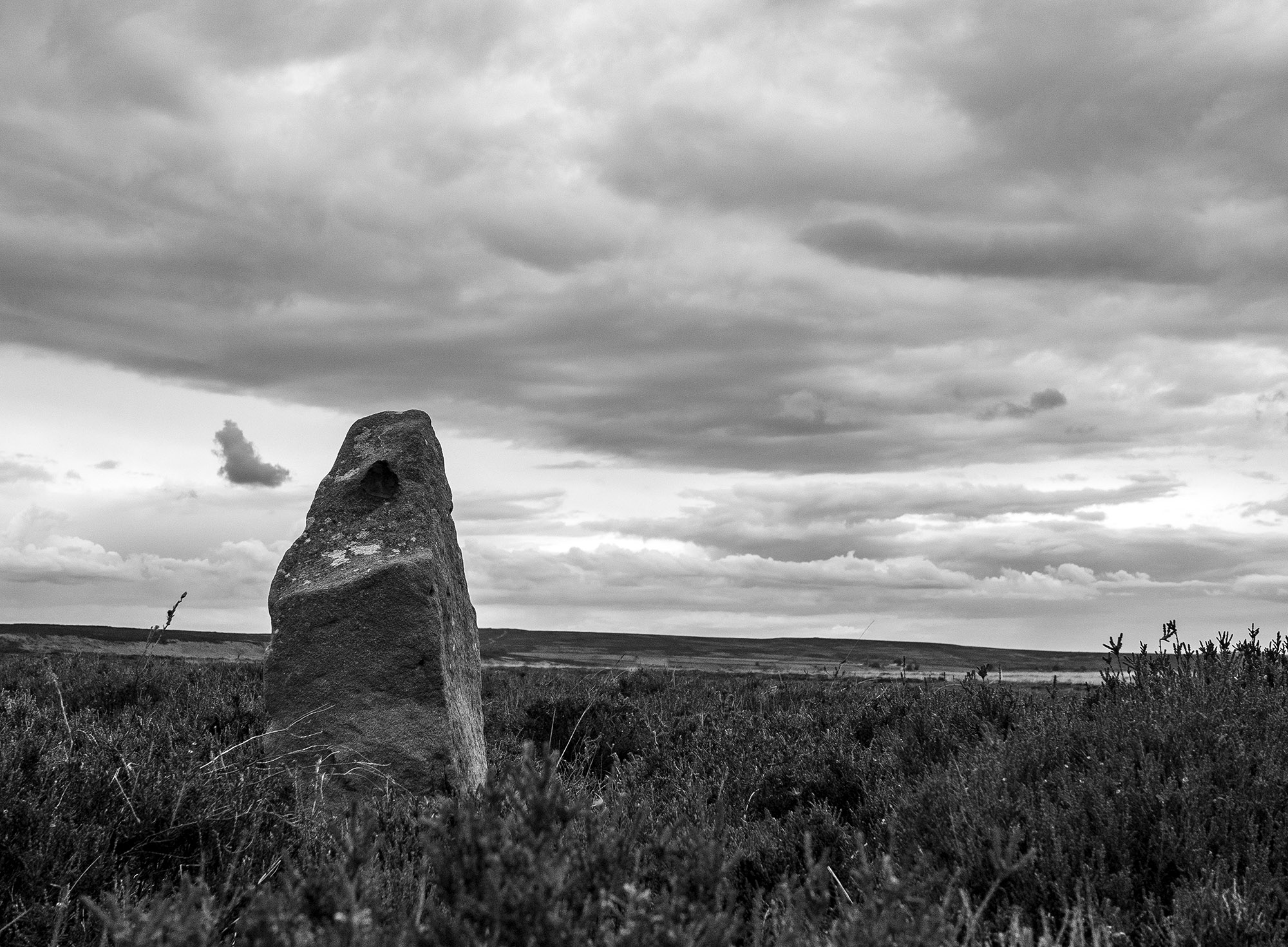
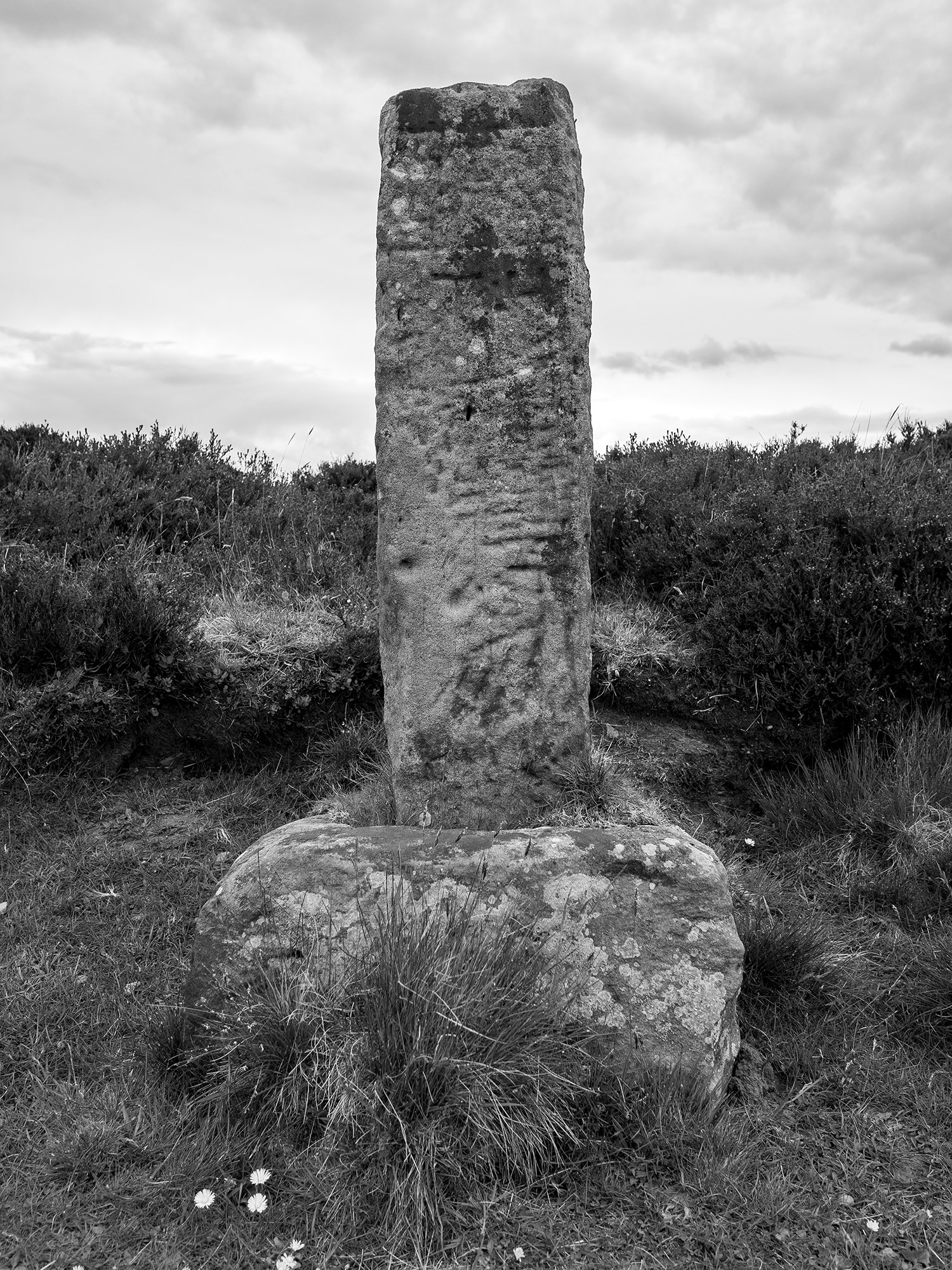
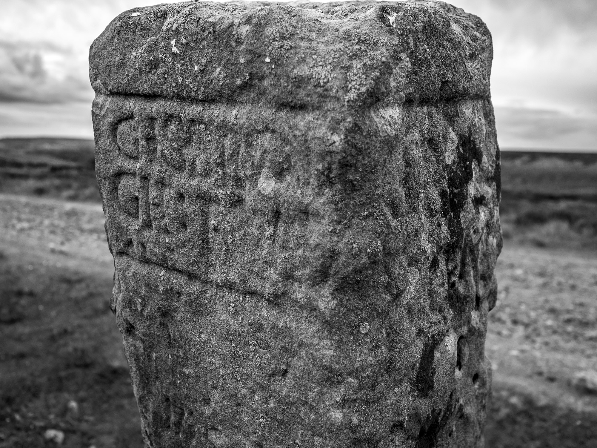
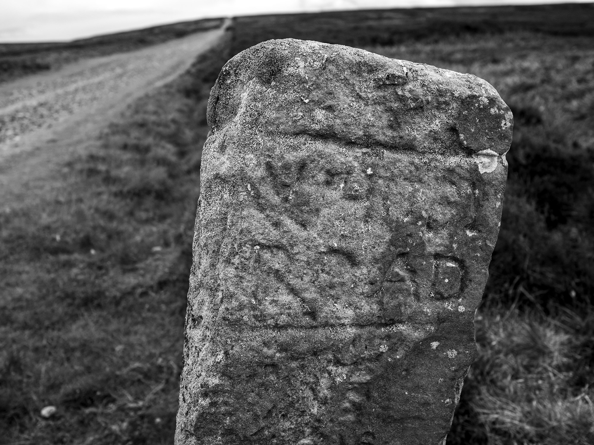
As I move onto the high moor guide stones mark the track. Many of these stones date to the 18th century, others may possibly be far older. On October 2nd, 1711, the Justices sitting at Northallerton ordered that guide posts should be erected throughout the North Riding.
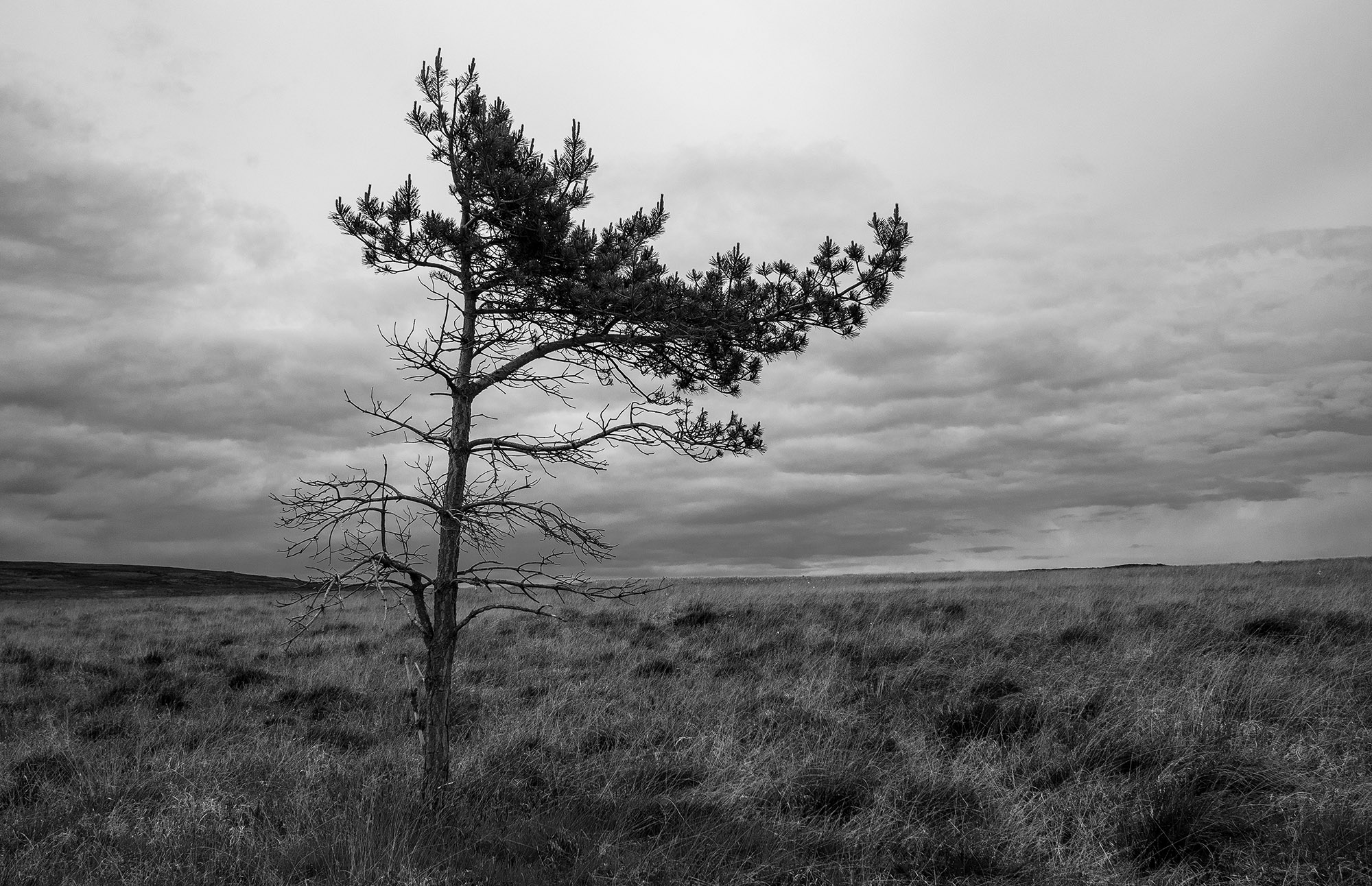
A solitary pine tree on the moor top, its branches indicate the direction of the prevailing winds.
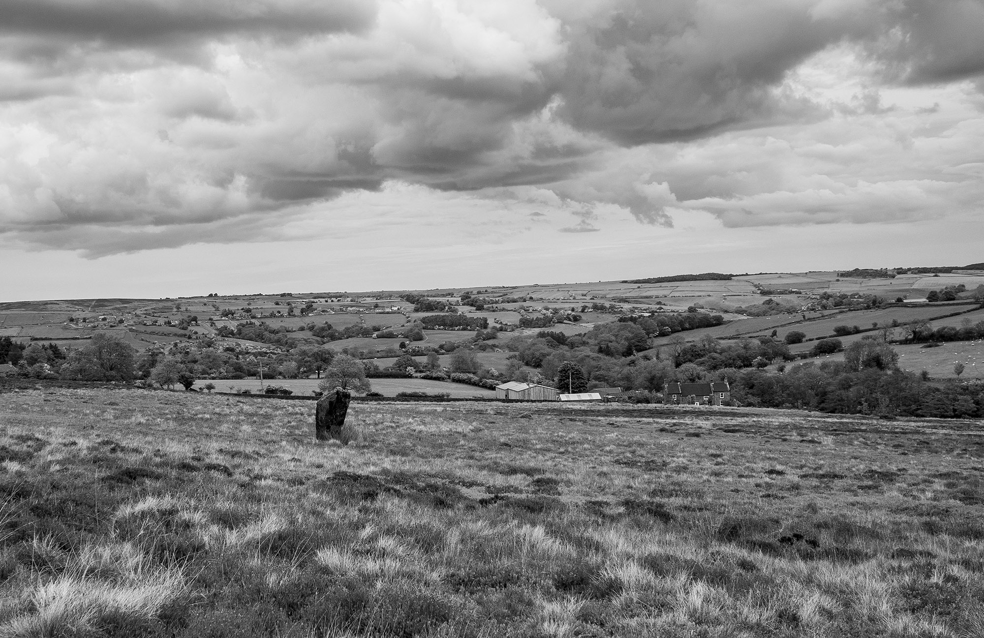
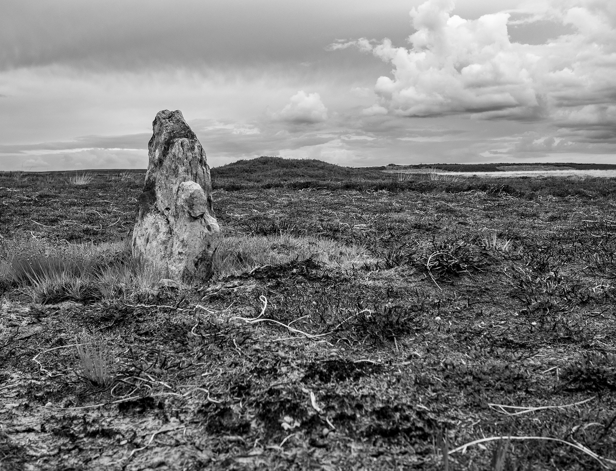
Walking across across the high moor towards Glaisdale I encounter a couple of low standing stones one of which is close to a low mound. These stones are not on the track and are too small to be guide stones. Another group of large stones look as through they were once standing but it is difficult to say much more about them.
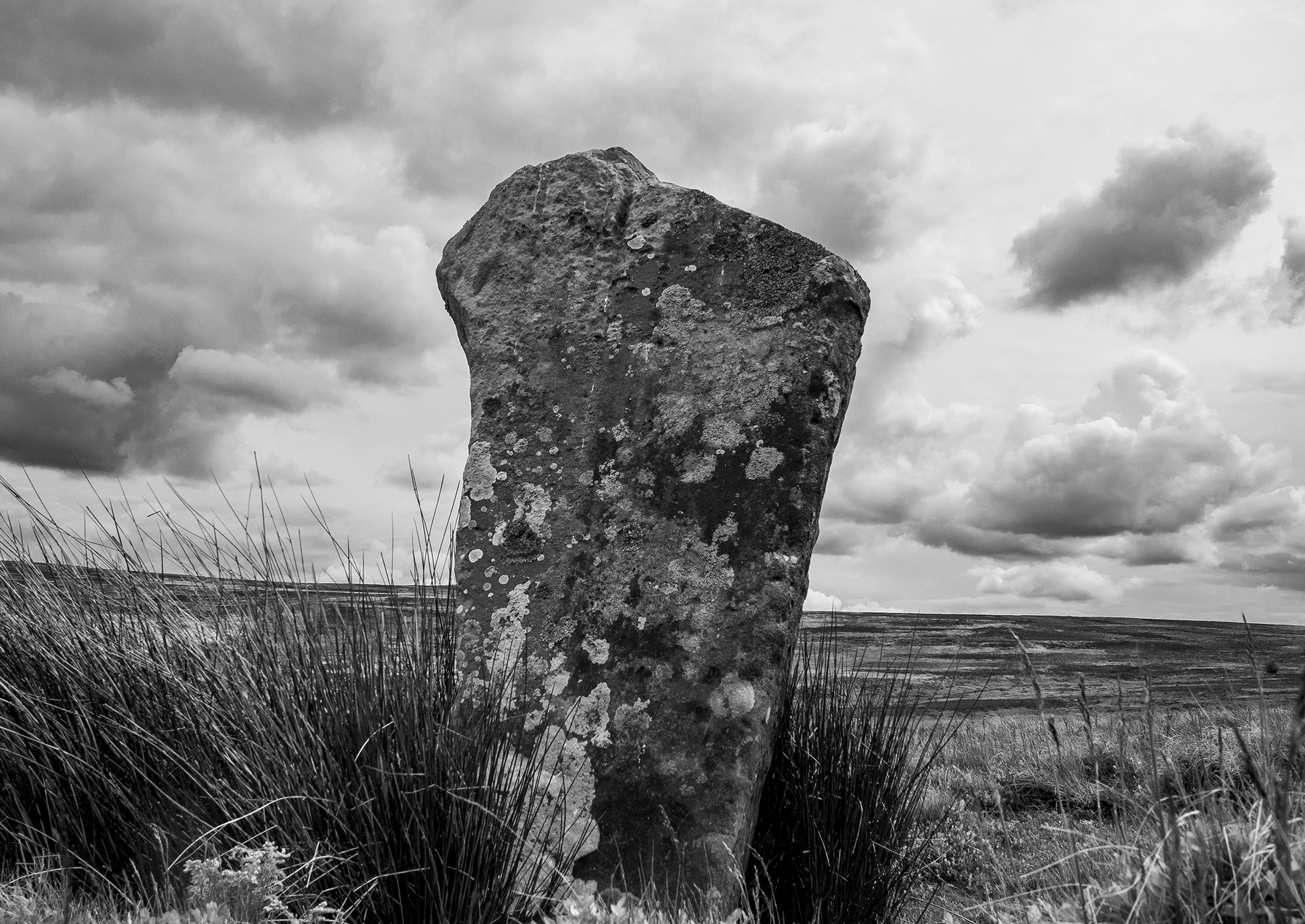
This guide stone was carved and erected by Thomas Harwood about 1735. Harwood erected four other similar stones on Glaisdale Rigg. The stone appears to be housed in an old cross base. It is possible to make out the inscriptions on the north and east faces, they read Gisbrogh Road and Whitby Road. The other two faces are illegible, Stanhope White writes that the south face reads Glaisdale Road TH.
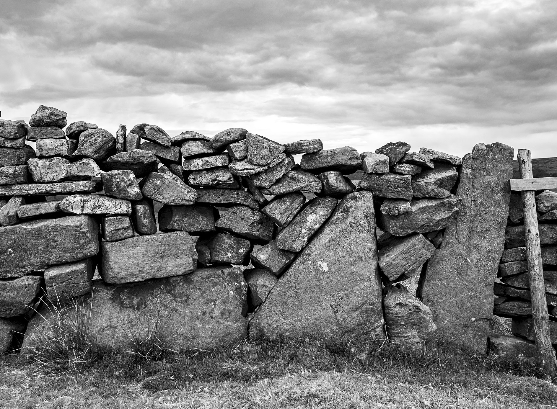
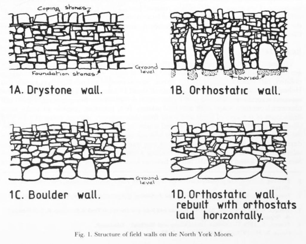
Walking over to the edge of Glaisdale I find this beautiful orthostatic wall, a real joy. About a century ago many of the original field walls across the moor and dales were rebuilt by professional wallers, this wall may be a survivor of an earlier age.
In his book, Some Reminiscences & Folk Lore of Danby Parish & District, Joseph Ford writes of Stone-Rearing Days. These were occasions when a farmers neighbours gathered together to build walls around newly-enclosed fields. Ford thinks that this tradition may stretch as far back in time to the original settlers of the moorland dales.
D. A. Spratt YAJ 60 1988
Etymology
Glaisdale – YN [Glasedale 12 Guisb. Glasedal 1223, Glasdale 1228 FF] ‘The valley of R Glas’
OW gleis, Welsh glais ‘stream’
Glas is a British river-name derived from the Welsh glas ‘blue, green, grey’
Sources
Yorkshire Wit, Character, Folklore & Customs. R Blakeborough. W Rapp & Sons Ltd. 1911
The North York Moors. An Introduction by Stanhope White. The Dalesman Publishing Co. 1979
Some Reminiscences & Folk Lore of Danby Parish & District. Joseph Ford. M.T.D. Rigg Publications. 1990
The Concise Oxford Dictionary of English Placenames. E Ekwall. 1974
Orthostatic Field Walls on the North York Moors. D.A. Spratt. Yorkshire Archaeological Journal No. 60 1988
My friend Graeme Chappell and I decided to have a wander around Thompson’s Rigg. We followed the Old Wife’s Way from Horcum, dropping down along Newgate Brow into the valley below.
We crossed the fields to take a look at the standing stones at the foot of Blakey Topping. These stones have been interpreted as a possible ruined stone circle.
After spending some time at the stones we walked onto Thompson’s Rigg. The Rigg is only a mile long, its flanks slope down into the valleys of the Grain Beck to the East and Crosscliff Beck to the west. The moor is surrounded on three sides by higher ground and gently slopes to the south where it narrows to form a valley which eventually leads to Langdale End and Howden Hill, a hill very similar in appearance to Blakey Topping.
About a third of the way along the Rigg the trackways bends, at this point, running diagonally to the trackway, is a cross ridge boundary. The boundary is a banked structure that bisects the full width of the moor and is topped, in parts, with large stones. The official scheduling for the area states that, Although this boundary forms part of the post-medieval field boundary system in the area, it is considered to incorporate elements of an earlier construction which had origins in the prehistoric period, contemporary with the cairnfield. source
In his book Early Man in North East Yorkshire Frank Elgee wrote, A wall of upright stones crosses the Rigg between the farm and the barrows, he also includes the boundary on his map of the area
It is curious that despite the earthwork being mentioned in the official scheduling of the area and despite it defining the the northern limit of the cairnfield and barrows and its close resemblance to other moorland cross ridge boundaries, this significant structure does not appear in either Don Spratt’s 1993 or Blaise Vyner’s 1995 inventories of the cross ridge boundaries of the North York Moors.
South of the large boundary earthwork we started to encounter many cairns, most are in deep heather and difficult to define, at least one of this group appears to be a large ruined barrow.
We continued south, traipsing through the deep heather to a grassy area containing a beautiful Platform Cairn. Platform Cairns are rare on the North York Moors, they are defined as, A roughly circular monument featuring a low, more or less level platform of stones surrounded or retained by a low stone kerb. Some may feature a small central open area, thus resembling a ring cairn. Source.
There is a large stone and hollow in the middle of the cairn implying a possible ruined cist, it is evident that this cairn had been excavated in the past. Graeme reminded me that we were only seven miles from Pickering, once home to James Ruddock.
James Ruddock was a nineteenth century commercial barrow digger. Between 1849 and his death in 1859 he opened many of our moorland mounds in search of finds to sell to the gentleman collectors of his time. His main client was the antiquary Thomas Bateman, he also opened barrows for Samuel Anderson of Whitby.
Unfortunately Ruddock did not always keep precise notes regarding the locations of his diggings, many of his finds have ended up in our museums with vague labels such as, from a mound 6 miles north of Pickering.
Moving further south we encountered this lovely, fairly well-defined ring cairn.
On the south eastern flanks of the Rigg is a group of hollow ways, these are not considered to be prehistoric.
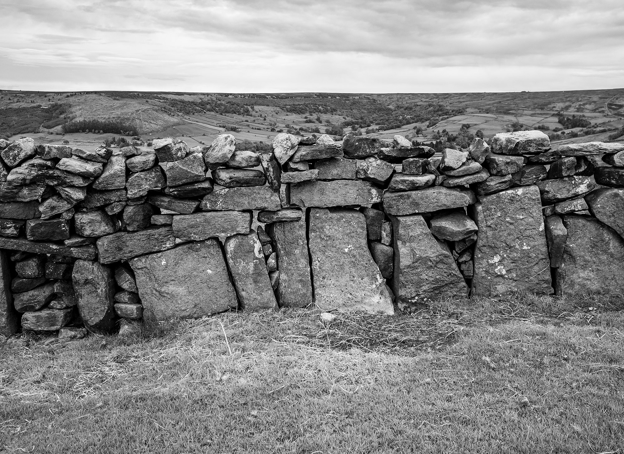
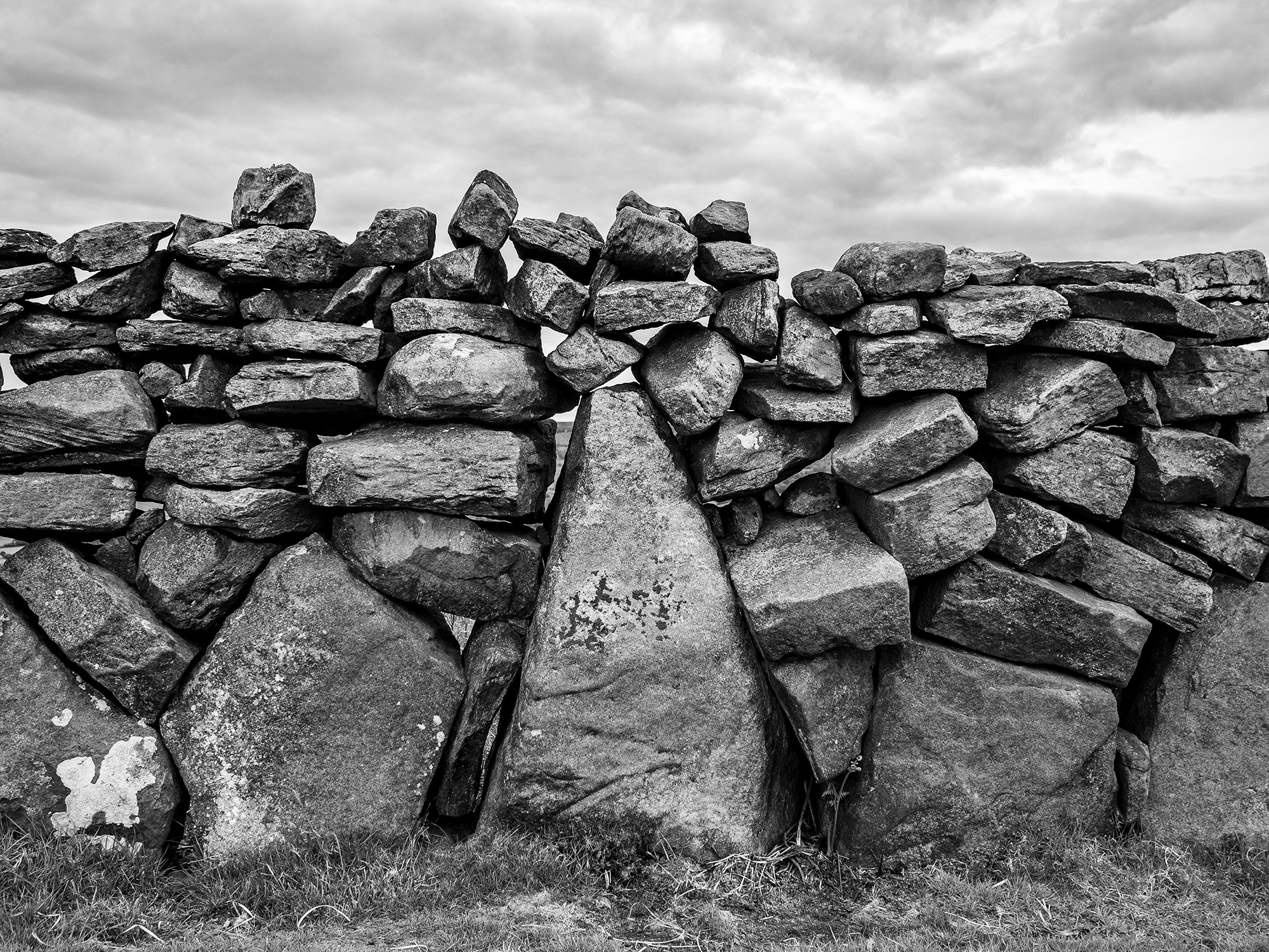
At the southern end of the Rigg is this orthostatic wall which contains many large stones, some of which appear to be buried into the ground. If the wall contained unburied stones it would be classed as a boulder wall. The walling is definitely not prehistoric but may contain stones from an earlier feature.
Not far from the walling is this three foot high standing stone, located within an area of low banks and cairns at the southern end of the Rigg.
Blakey Topping and Thompson’s Rigg are well worth a visit, There is a wealth of prehistoric remains to be seen within a relatively small area. The area is owned by the National Trust and is not managed for grouse so has a mixture of habitats, we saw plenty of birds including Skylarks, Snipes and what I think were a large flock of Fieldfares.
If you visit this lovely place, what you’ll undoubtably notice is that wherever you are on the moor, Blakey Topping is the dominant landscape feature. Graeme and I agreed that this beautiful hill probably had a deep significance to the original inhabitants of this area. A sacred hill? perhaps even a sacred landscape?
Resources
Early Man in North East Yorkshire. Frank Elgee. 1930
Orthostatic Field Walls on the North York Moors. D A Spratt. YAJ Vol. 60. 1988
Linear Earthworks of the Tabular Hills, Northeast Yorkshire. D A Spratt. 1989
Prehistoric and Roman Archaeology of North-East Yorkshire edited by D A Spratt. 1993
CBA Research Report 101: Moorland Monuments’ in The Brides Of Place: Cross-Ridge Boundaries Reviewed, B Vyner. 1995
Howe Hill is a prominent mound in the centre of the village. It was previously thought to be a Norman earthwork or Motte but is actually a prehistoric burial mound dating from the Late Neolithic period to the Late Bronze Age. The site is still marked on the modern maps as a Motte.
The barrow has a beautiful tree growing on it and sits upon a natural knoll that has been bisected by the main road into the village. The primary views from the barrow are to the west across the Vale of Mowbray to the distant Pennines.
There is a Norman connection with the village, the local church was rebuilt in the mid-nineteenth century contains a number of Romanesque carved stones including this lovely capital depicting foliate heads.
In common with most people I feel as though many aspects of my life have been on hold for the past 12 months. My list of places to visit gets longer and longer. Now that lockdown is easing I seem to have a mental log-jam of what to do and what to see.
I have been planning on visiting the Cross Dyke of Horn Ridge for quite some time as it is one of the few local dykes that I haven’t visited. Once again, it was a chance online conversation with a friend that spurred me into action.
The sun was shining, the forecast was giving out wintery showers, this was perfect for me, half decent weather and less chance of meeting anyone on the moor-top.
I drove down to Farndale and walked up the keepers track that runs up the side of Monket House Crags. The track is not too steep and takes you through an area covered in spoil heaps from the 19th century jet workings. When I started walking the sun was shining, within a few minutes a wintery squall blew in from the north leaving a dusting of snow on the hillside. The squall was intense but short-lived, this became the pattern for the rest of the day.
I followed the track south along the gentle rise of Horn Ridge. From the high point the land begins to gently slope down to the south, the eye is drawn along the valley of the River Dove to the dale end with the moorland above Hutton Le Hole and the Vale of Pickering in the far distance.
As you walk down towards the very obvious earthwork you become very aware that you are on a narrowing promontory of moorland , the fertile dale on either side, hemmed in by the dark domineering presence of Rudland Rigg to the West and Blakey Ridge to the East. As you near the Dyke you can see through the central gap to a fairly level area with the barrow beyond, the effect is quite striking.
The Dyke itself runs the full width of the upland, terminating where the land drops off at either end. Its total length is approximately 300m.
Approaching it from the north it appears to be quite an impressive earthwork fronted by a deep ditch that has been dug along its whole length. When viewed from the south it appears less imposing.
A section of the Dyke was excavated by Raymond H. Hayes. He was unable to find any evidence that might give a date to the earthwork. He observed that with the ditch ‘its builders did not cut the rock as in Iron Age or Roman ditches.’
There are a couple of stone settings within the dyke on the south side but these look relatively recent, a modern shelter or grouse butt and a trap built by keepers to catch small mammals. These moors are not a friendly place for any creature that vaguely threatens the grouse population. Last year 5 dead Buzzards were discovered hidden beneath a rock just 3km north of the Dyke.
Walking south towards the barrow, a squall blows through and the views are lost.
The barrow is a sad sight. It’s quite large, approx 10-15m diameter. It’s hard to fully gauge the dimensions due to it’s in a terrible state of repair of the structure. The scheduling entry for the monument mentions ‘a central excavation hollow around 4m by 2m, with a second 1m diameter pit in its west side.’ The keepers have also recently built a trap into one of the holes in the mound.
I took wander over to the western edge of the ridge. There are reports of cairns and hut circles in this area. I was just starting to spot them when it started to snow quite heavily. My mind turned to driving home and having to tackle the steep bank from the dale bottom up to Blakey Ridge. Under normal circumstances I wouldn’t mind being trapped in Farndale but with the current conditions i.e. the Feversham Arms being closed, I decided that the western edge of Horn Ridge was one for another day and turned for home.
A recent online conversation with a friend re-sparked my curiosity about the Tank Road. It’s an area that I’ve visited many times over the years, I’ve always felt that it was an important place but I’ve never fully got to grips with it. So I decided to walk it and try to pull together a description of the area.
I’ve always known it as the Tank Road or Old Tank Road, presumably it got this name from when it was used as a Tank training ground during WWII. The road itself is only 3.5km long, it runs between the main north-south roads to Castleton and Danby. From east to west, the road starts on the main north-south road to Danby and then crosses Gerrick Moor, Tomgate Moor and Middle heads where it meets the Castleton Road at White Cross on Three Howes Ridge.
On walking the road it becomes apparent that it was a busy route in the past, there is evidence of a number of sunken trackways, following the line of the road and joining the road from other routes, this becomes more obvious when you look at the LIDAR images of the area.
Regarding the origins of the road itself. There have been two excellent books written on the trackways of the North York Moors, Old Roads and Pannierways in North East Yorkshire by Raymond H. Hayes and Trods of the North York Moors by Christopher P. Evans. Hayes regards the route as possibly part of the Pannierman’s Causeway from Castleton to Staithes. Evans thinks it is part of a trod from Liverton Moor to Commondale. I suspect this route may have its origins in Prehistory.
Walking from east to west.
The road starts at the bend of the road that runs from the A171 to Danby where there is a small parking area. I definitely would not recommend trying to drive along the road. The road crosses a number water courses, the boggy areas have been filled with building rubble, it’s not unusual to find parts of cars on the side of the road.
The most prominent monument at the start of the road is a large Barrow, one of a group known as Robin Hood’s Butts. Danby Beacon can be seen in the distance in the image above .
The next group of monuments lie just south of the road comprising of a barrow and an embanked circular feature known as an Enclosed Urnfield. The enclosure and barrow date to the Bronze Age. The enclosure was a place where the cremated remains of the dead were placed, often in small pottery vessels. This type of monument is quite rare, they are generally only found in Northern England and Southern Scotland. Only 50 examples are known, 3 of which are within a few minutes walk of the Tank Road.
Photographing many of these prehistoric monuments is quite difficult, most of them are fairly low-lying features, covered in heather on a heather moor. The vegetation is quite low at the moment so this is probably the best time of the year to visit and once you get you eye in they are not to difficult to spot. I’ve included a few Open Access LIDAR images as they give a better idea of the form of the monuments.
To the north of the road is a large standing stone. The stone is unusual as it is ‘L’ shaped and its surface has fossil ripple marks on its surface. There are no obvious outcrops of stone on this part of the moor, but there is an outcrop with similar ripple marks on the western flanks of Siss Cross Hill just under 2km away. Perhaps this was the source of the stone.
In the top image, behind the standing stone, you can see the large burial mound of Herd Howe in the middle distance and beyond that Freebrough Hill. Just below Herd Howe is an enclosure that dates to the Iron Age. I have previously written an account of the enclosure, Herd Howe and the nearby Cross Dyke.
On my last two walks along the road I have seen quite a number of geese. I presume they are overwintering here. On my last visit this pair flew towards me honking, circled me and then headed back to Dimmingdale.
Leaving the road I followed a track south to have a look at Siss Cross. The cross is a crude unworked upright stone, it may be a replacement for the original cross. Running down the hill from the cross are a number of sunken trackways, perhaps the cross was a route-marker. Back in the 19th Century local Antiquarian J.C Atkinson discovered what he described as a flint tool making site just south of Siss Cross. He collected enough flint tools and debitage to fill ‘half a fair sized fishing basket’. The flint tools are thought to have been made by Mesolithic hunter gatherers. The site would have been a good place for a hunting camp, it is well drained and has a large viewshed, even on a muggy day I was able to look along the Esk Valley and make out the distinctive profile of the RAF site on Fylingdales Moor over 21km away.
I headed back to the Tank Road via the Trig point on the top of Siss Cross Hill. There is another Enclosed Urnfield with associated Barrows here. Unlike the previous enclosure this one is oval in shape and quite large 38x20m. Interestingly, the enclosure and the two associated barrows are aligned on the western-most Barrow of the Robin Hood’s Butts group. This alignment is also roughly the direction of the Midsummer sunrise and Midwinter sunset. The enclosure is also intervisible with the third Enclosed Urnfield on Moorsholm Rigg.
I walked back onto the road from Siss Hill and followed it down into Ewe Crag Slack. The slack is a former glacial drainage channel and is generally quite boggy. The keepers and the farmer struggle to keep the road passable down here, the place is a jumble of boulders, concrete posts and deep muddy ruts.
Ewe Crag Slack is a significant location in the study of prehistory on the moors as it was one of a number of places where Paleoenvironmental pollen cores were taken from the peat and the sediments below it. The data from Ewe Crag helped provide evidence that the people who lived here during the Mesolithic period may have been actively managing the land. The pollen cores showed evidence of forest destruction and subsequent soil erosion, this combined with charcoal deposits suggests that people may have been creating forest clearings much earlier that was previously thought.
I noticed this boulder by the side of the road. The boulder has been broken but you can see that it’s original form was rounded. The rock type looks like a fine grained igneous rock, basalt or andesite. I presume it is a glacial erratic. It’s curious because less than a kilometre away, at Dimmingdale, is a barrow that was excavated in the 19th Century by J.C. Atkinson, the same antiquarian who found the Siss Cross Flints. Atkinson wrote that the barrow contained ‘blocks of basalt from the Cleveland Dyke’. It is possible that the stones came from the Cleveland Dyke, the nearest potential outcrop that I’m aware of is at Scale Cross 4.2km away, where it was quarried in the modern era. I wonder if the barrow stones may have originated closer to home as glacial erratics washed-down to Dimmingdale when the ice began to melt. One for further research.
Walking the final section of the road to White Cross my camera battery died. The final 2 images were taken when wandering the road in 2017, they are a Danby-Moorsholm guidestone & White Cross.
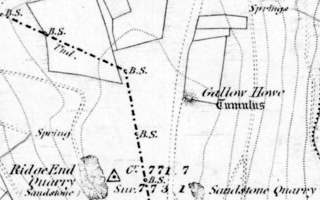
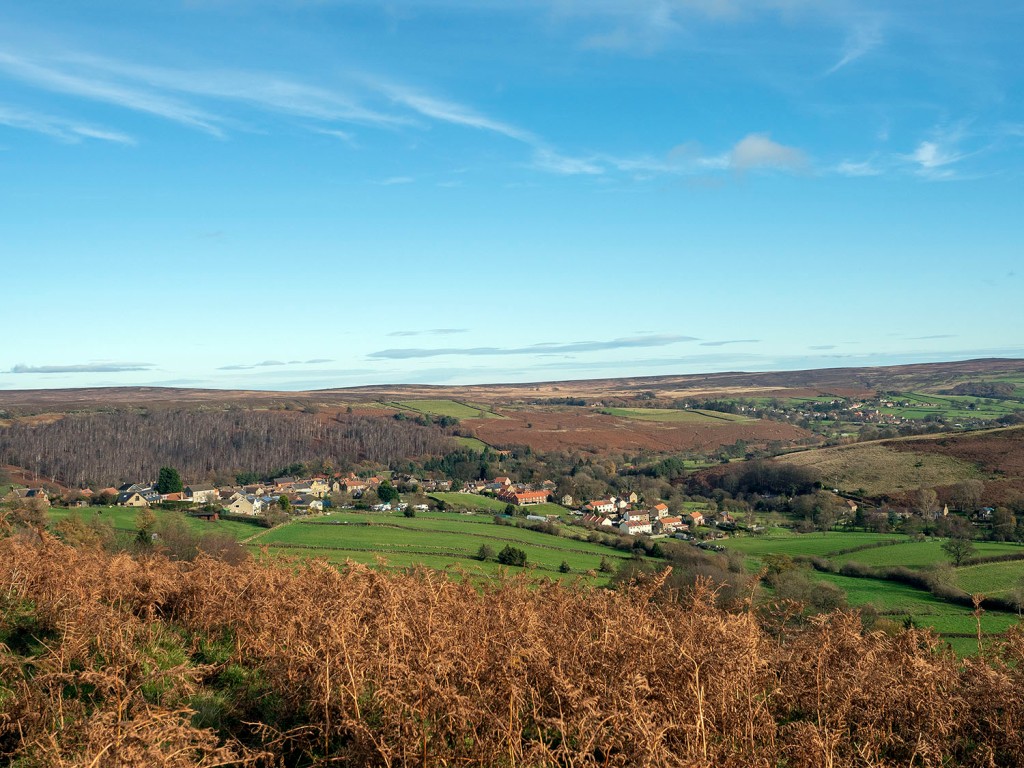
Gallow Howe was a large prehistoric burial mound located beside the moorland road that runs across the high moors connecting Eskdale with the Vale of Pickering. Today, there are no traces of the mound to be seen and it is no longer marked on the OS maps.
In 1863 R.C Atkinson, described the mound as a chambered cairn 7 – 8 feet in height and about 9 yards in diameter, with a kerb of stones standing 3-4 feet high around its base. On excavating the mound, an internal dry stone walled chamber or cist, 5 feet long 3 feet wide, was found. The excavator dug 5-6 feet down into the cist and found nothing.
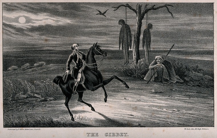
Atkinson also tells us that there was a tradition that a gallows once stood on or near to the mound.
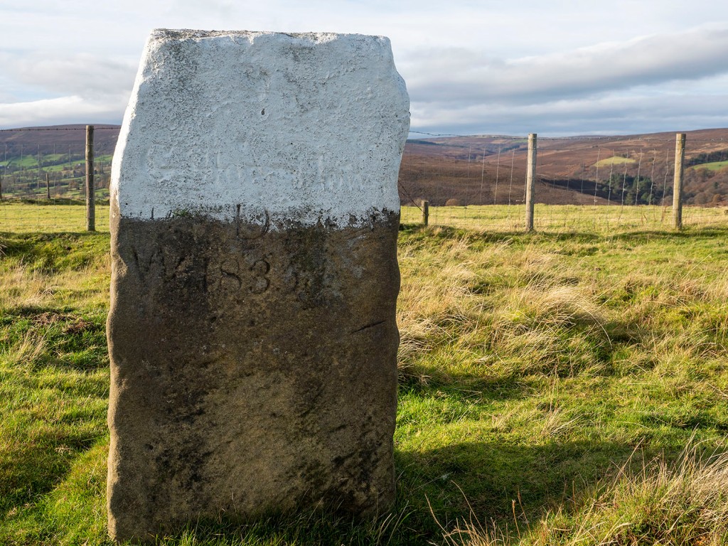
It’s unfortunate that large cairns close to roads were often used as convenient quarries for road menders and stone wallers. Today, the only trace of the site is a nearby stone carved with the name Gallow How, the stone is one of 25 erected along length of Castleton Rigg to mark the boundary between the Westerdale and Danby estates.
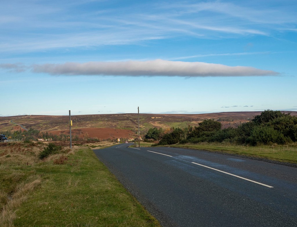
The site is intervisible with other large barrow groups along the Esk Valley margins including Danby Beacon which can be seen on the far right of the image above.
A lorry passing the site of Gallow Howe carrying moorland stone… there’s a metaphor here somewhere.
In her book, An Illustrated Guide to Stone Antiquities on the North Yorkshire Moors, Elizabeth Ogilvie wrote that the gallows was in use until around 1760 and that a gibbet* stood on the howe long after it was last used.
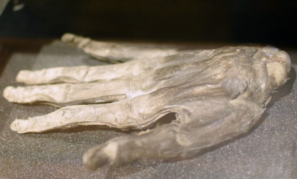
She also wrote that the Hand of Glory, which is now in the Whitby Museum, was alleged to have come from a corpse hanged on Gallow Howe.
Gallows sites were viewed as places of dread, inhabited by the lost souls of those executed, they were often located in liminal places. This site, a gallows built on top of a pagan burial mound, on an estate boundary, on an empty moor would have been seen and understood by everyone travelling to the dale. Two thousand years earlier, the Chambered Cairn may have been located here for similar reasons.
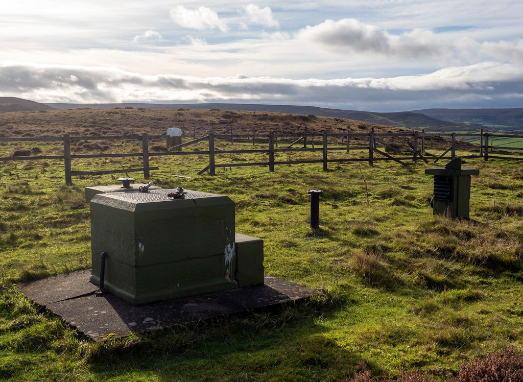
The site maintained its strategic value into the twentieth century. During the Second World War it was used by the Royal Observer Corps. During the Cold War an underground bunker was built on the site to monitor radiation levels during a nuclear attack. The bunker was abandoned in the 1990s and has recently been restored and can be visited on open days
* A gibbet was a cage or set of chains where the body of the hanged person was left to rot as a warning. The body was sometimes covered in tar to preserve it.
Sources
Map extract reproduced with the permission of the National Library of Scotland’
J.C. Atkinson. Traces of our Remote Ancestors The Gentleman’s Magazine Vol. 214. 1863
E. Ogilve. An Illustrated Guide to Stone Antiquities on the North Yorkshire Moors. 1996
The road on Percy Rigg runs from Rosedale Head to Guisborough. The section that runs over Percy Rigg is called Ernaldsti, after Ernald de Percy, Lord of Kildale. On a grim drizzly day I decided to walk the road from its junction with the Kildale – Commondale road to Percy Cross.
The surrounding moors are also dotted with standing stones, some are prehistoric, others are estate boundary stones. There are the remains of a large prehistoric settlement on the south west slope of Brown Hill. In 1953 Archaeologist Paul Ashbee excavated a number of small cairns and a large round barrow on Brown Hill. He discovered a rock-cut burial pit beneath the barrow and very little in the cairns, concluding that they were probably clearance cairns.A number of the earthfast stones beside the road are marked with benchmarks.
Local Archaeologist Roland Close excavated a group of hut circles beside the road. He found two large huts with paved floors, two smaller huts with central hearths and one hut with drainage ditches cutting through the two smaller huts. The main finds were nine saddle querns and some poorly-fired pottery sherds.
Close published his excavation in the Yorkshire Archaeological Journal. In his report he mentioned a permanent spring to the north of the huts, probably the primary source of water for the settlement.
On looking through some old maps of the area I noticed that, on the 1950 OS map, a cluster of tumuli had been marked around the spring. If these tumuli were burial mounds it could mean that that spring held some significance, other than a source of water, to the people who lived there in the past.
The spring emerges from the hillside into a man-made stone-lined trough and then flows down to the Codhill Beck. There is a standing stone close to the well, the sides of the stone have been dressed, this is probably an estate boundary stone. Unfortunately the moor above the site is covered in deep heather, I was unable to find the mounds marked on the OS map.
On the coast between the Tees and Whitby there are two main high points, Warsett Hill above Brotton and Rockcliffe Hill above Boulby. These hills are also mutually visible, each with a group of Bronze Age barrows on their summits. The two summits are also intervisible with a number of moorland prehistoric sites.
There were once the remains of seven mounds on Warsett Hill but they have been ploughed-out leaving no trace on the ground. The group consisted of a cluster of six small mounds and one larger mound. The first recorded investigations of the group was by Canon Atkinson. Atkinson looked at the six small mounds and found nothing.
William Hornsby and Richard Stanton excavated the mounds in 1917, they found a few flints in the smaller mounds. The larger mound, which had been left untouched by Atkinson, was more fruitful. On opening the mound they discovered a ring of stones 30 ft in diameter, at the centre of which was a cremation burial with two food vessels. Other finds in this mound included a sherd of domestic pottery, a knife, a saw and many flints including scrapers, cores, and two leaf shaped arrowheads.
Sources
Pastscape.org.uk
Yorkshire Archaeological Journal 24. 1917
Bronze Age Barrows in Cleveland. G.M. Crawford. 1980
Map reproduced with the permission of the National Library of Scotland