I took a journey to visit the shrine of Tigh na Cailliche, located in a remote glen at the head of Glen Lyon.
In spring an estate worker brings the stones out of the low turf-roofed shrine. The stones are returned at the onset of winter. The largest water-worn stone is known as The Cailleach, hag, old woman. The second largest is known as The Bodach, old man, husband. The third largest stone is The Nighean, daughter or girl.
My friend Graeme Chappell and I decided to have a wander around Thompson’s Rigg. We followed the Old Wife’s Way from Horcum, dropping down along Newgate Brow into the valley below.
We crossed the fields to take a look at the standing stones at the foot of Blakey Topping. These stones have been interpreted as a possible ruined stone circle.
After spending some time at the stones we walked onto Thompson’s Rigg. The Rigg is only a mile long, its flanks slope down into the valleys of the Grain Beck to the East and Crosscliff Beck to the west. The moor is surrounded on three sides by higher ground and gently slopes to the south where it narrows to form a valley which eventually leads to Langdale End and Howden Hill, a hill very similar in appearance to Blakey Topping.
About a third of the way along the Rigg the trackways bends, at this point, running diagonally to the trackway, is a cross ridge boundary. The boundary is a banked structure that bisects the full width of the moor and is topped, in parts, with large stones. The official scheduling for the area states that, Although this boundary forms part of the post-medieval field boundary system in the area, it is considered to incorporate elements of an earlier construction which had origins in the prehistoric period, contemporary with the cairnfield. source
In his book Early Man in North East Yorkshire Frank Elgee wrote, A wall of upright stones crosses the Rigg between the farm and the barrows, he also includes the boundary on his map of the area
It is curious that despite the earthwork being mentioned in the official scheduling of the area and despite it defining the the northern limit of the cairnfield and barrows and its close resemblance to other moorland cross ridge boundaries, this significant structure does not appear in either Don Spratt’s 1993 or Blaise Vyner’s 1995 inventories of the cross ridge boundaries of the North York Moors.
South of the large boundary earthwork we started to encounter many cairns, most are in deep heather and difficult to define, at least one of this group appears to be a large ruined barrow.
We continued south, traipsing through the deep heather to a grassy area containing a beautiful Platform Cairn. Platform Cairns are rare on the North York Moors, they are defined as, A roughly circular monument featuring a low, more or less level platform of stones surrounded or retained by a low stone kerb. Some may feature a small central open area, thus resembling a ring cairn. Source.
There is a large stone and hollow in the middle of the cairn implying a possible ruined cist, it is evident that this cairn had been excavated in the past. Graeme reminded me that we were only seven miles from Pickering, once home to James Ruddock.
James Ruddock was a nineteenth century commercial barrow digger. Between 1849 and his death in 1859 he opened many of our moorland mounds in search of finds to sell to the gentleman collectors of his time. His main client was the antiquary Thomas Bateman, he also opened barrows for Samuel Anderson of Whitby.
Unfortunately Ruddock did not always keep precise notes regarding the locations of his diggings, many of his finds have ended up in our museums with vague labels such as, from a mound 6 miles north of Pickering.
Moving further south we encountered this lovely, fairly well-defined ring cairn.
On the south eastern flanks of the Rigg is a group of hollow ways, these are not considered to be prehistoric.
At the southern end of the Rigg is this orthostatic wall which contains many large stones, some of which appear to be buried into the ground. If the wall contained unburied stones it would be classed as a boulder wall. The walling is definitely not prehistoric but may contain stones from an earlier feature.
Not far from the walling is this three foot high standing stone, located within an area of low banks and cairns at the southern end of the Rigg.
Blakey Topping and Thompson’s Rigg are well worth a visit, There is a wealth of prehistoric remains to be seen within a relatively small area. The area is owned by the National Trust and is not managed for grouse so has a mixture of habitats, we saw plenty of birds including Skylarks, Snipes and what I think were a large flock of Fieldfares.
If you visit this lovely place, what you’ll undoubtably notice is that wherever you are on the moor, Blakey Topping is the dominant landscape feature. Graeme and I agreed that this beautiful hill probably had a deep significance to the original inhabitants of this area. A sacred hill? perhaps even a sacred landscape?
Resources
Early Man in North East Yorkshire. Frank Elgee. 1930
Orthostatic Field Walls on the North York Moors. D A Spratt. YAJ Vol. 60. 1988
Linear Earthworks of the Tabular Hills, Northeast Yorkshire. D A Spratt. 1989
Prehistoric and Roman Archaeology of North-East Yorkshire edited by D A Spratt. 1993
CBA Research Report 101: Moorland Monuments’ in The Brides Of Place: Cross-Ridge Boundaries Reviewed, B Vyner. 1995
You know me as The Old Wife, I have many names in many lands, my true name is lost to you. In your world I am Carling, Gyre, Calliach, Cailich, Calli, Kerling, Kelling, Kjerring, Karring, Kaelling. I am also Black Annis, Cally Berry, Bell, Witch, Gentle Annie, Bronach, Mala Lia, Glaistig, Muilgheartach, Boi, Hag, Crone, Bone Mother, Veiled One, Thunderer, Frau Holle, Mardoll, Morrigan, Daughter of Frenzy.
Where do you come from?
I was always here. I am before time and place, I am below and above.
What is your purpose?
I command the weather and summon winter, I rule the dark months. I made your mountains, crags, forests and moors. Your rivers run because of me. The coastlines, islands, headlands, and cliffs are my work. I close your harvest and protect your animals. Gods, giants, kings and mortals have shared my bed, my offspring people the world. I am the bringer of death and the mother of all.
Ainthorpe – Old Wife’s Stones Road – Ring Cairn with Standing Stone – Cairnfield – Round Barrow – Church Way (The Old Hell Road) – Enclosure 738 (Ring Cairn) – Double Dykes
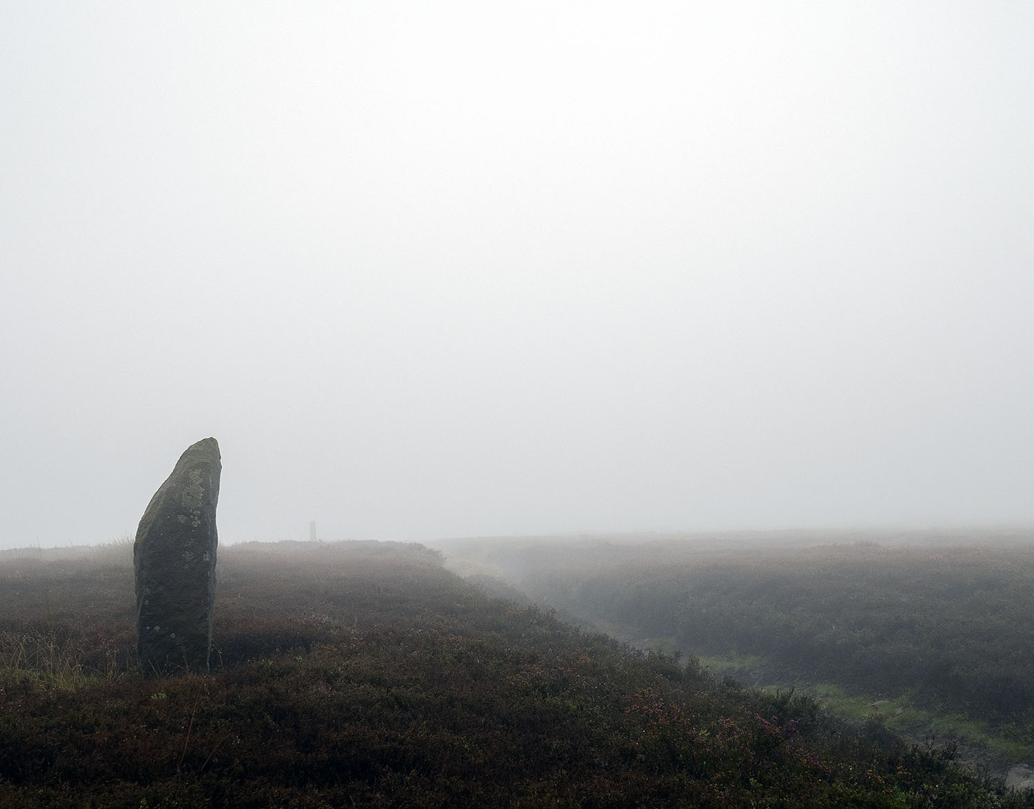
I returned to the Rigg a couple of days later with my friend Graham. The Rigg was shrouded in low cloud with visibility down to 20-30 metres. The lack of visibility gave the Rigg an otherworldly atmosphere, upright stones looming in and out of the murk, the scarp edges of the Rigg dropping-off into an apparent void, the sound of sheep and the voices of a walking party echoing across the moor, amplified by the dense fog.
Graham had not visited the Rigg before and I was keen to show him some of its archaeological features. What soon became apparent was that it is almost impossible to give a full account of such a complex site when you cannot reference the landscape that it sits in. The loss of the viewsheds from the monuments and trackways on the Rigg made it extremely difficult to explain their relationships with each other and with the greater landscape that they sit in. We settled for having a look at a few hoary old stones and enjoying the damp otherworldliness of the moor.
One thing we did notice on the moor and have seen elsewhere this year, was the poor condition of much of the heather. The heather should be in full bloom at the moment carpeting the moorlands in purple. This year, much of the heather is not only without blossom but is also brown and withered. Apparently this is due to an infestation of Heather Beetles across the moors. More information can be found here
Little Fryup Dale – Crossley Side – Old Wife’s Stones – Enclosure 738 (Ring Cairn) – Rake Way – Double Dykes – Bakers Nab – Hanging Stone
If you have an interest in history Danby Rigg is a great place to visit. It was a busy place in the past, the northern end of the Rigg is covered in prehistoric cairns, low walls, embanked pits, hut circles and dykes. There are also Medieval features including the Viking-Age Double Dykes, iron bloomeries and trackways. Many of these features are quite subtle, especially where the heather is long, but once you get your eye in you begin to spot them everywhere, trying to make sense of them is a different matter.
The Rigg is also rich in folklore with the Old Wife’s Stones and a Corpse Road which leads from Fryup Dale across the Fairy Cross Plain to St Hilda’s Church in Danby Dale. The dales around the Rigg are littered with tales of Hobs, Spitits and Witches.
Many years ago, when I first started visiting the Rigg, I was overwhelmed by the amount of prehistoric remains that could be seen. Over the years I have learned to focus my visits on one or two features and try and work out their relationships to the landscape.
On this visit I decided to take a look at a natural feature called The Hanging Stone. On my way to the stone I thought I’d have a quick look at the Old Wife’s Stones and a large circular monument close to the Double Dykes. It was a blistering hot day with barely a breeze, following the Old Wife’s Stones road up the side of the Rigg, I realised that midday was probably not the best time to be doing this.
On old OS maps the Old Wife’s Stones are shown as a pair of stones, today only one remains. It sits close to the Old Wife’s Stones Road at the base of the steep scarp and overlooks Little Fryup Dale, the Fairy Cross Plain and Round Hill. On the image above the road running off to the top left follows the route of the Church Road also known as The Old Hell Road, a late Medieval Corpse Road that runs over the Rigg from Fryup Dale to St. Hilda’s Church in Danby Dale.
Just to the north of the Double Dykes is a large circular monument. The ring has a diameter of approximately 20 metres, it comprised of a low stone-built ring with a possible northern entrance.
This site was interpreted in the past as a settlement site. It was originally excavated by Atkinson in 1863. It was excavated again in 1956 by W.H. Lamplough and W.P. Baker and then re-examined by A.F Harding and J. Ostoja-Zagorski in 1984. Harding’s conclusion was that it was an Early Bronze Age, Ring Cairn, one of a number of similar monuments that run across the Rigg.
Walking on to the Double Dykes, a number of fairly low upright stones can be seen along the earthwork.
The Hanging Stone sits on the scarp edge of the Rigg overlooking Danby Dale. The rock itself is part of the Dogger Formation, a group of sandstones formed in shallow seas 170-174 million years ago. The stone is covered in graffiti, there are also a number of cup marks, one of which shows signs of being pecked. Given the amount of modern graffiti on the stone it is impossible to say whether the cup marks are prehistoric or modern.
Sources
Prehistoric and Early Medieval Activity on Danby Rigg, North Yorkshire. A.F. Harding with J Ostoja-Zagorski. Royal Archaeological Institute 151, 1994.
The Place Names of the North Riding of Yorkshire. A.H. Smith 1928
The Old Wifes Way – Newgate Brow – Newgate Moor – Grime Moor – Bridestones Griff – Needle Point – Dove Dale – Staindale – Adderstone Rigg
The Old Wife’s Way has always been a bit odd, today is no exception. The plane owner gives us a wave. We later see him flying over the fields.
We follow the Prehistoric Dyke along Newgate Brow. I will never tire of this view.
We leave the track and cut out onto Grime Moor, a slow worm scuttles through the shimmering red grass. An undisturbed barrow occupies the high ground
After crossing a large enclosure, we choose to follow the less trodden path around the High Bridestones.
The Low Bridestones on the opposite side of the valley. The steep-sided valleys of the Tabular Hills are called Griffs. They are the product of ancient climate change. The melting of the permanent ice during the last Ice Age caused lakes to build up behind ice dams, when the dams finally burst, huge torrents of water and debris formed the valleys that we see today.
One folktale concerning the origin of how the Bridestones got their name concerns a pair of newlyweds who died after spending the night in one of the shallow caves that exist beneath a number of the stones.
There is some debate on precisely how the Bridestones were formed. What we do know is that the the outcrops are composed of Calcareous Gritstone and Passage Beds and have been subjected to processes of erosion.
We walk along Needle Point and drop into the beautiful meadows of Dove Dale and Stain Dale.
We follow the road out of the dale to Adderstone Rigg to take a look at the Adder Stone. Within half a kilometer of this massive stone there are two large Prehistoric Barrow Cemeteries, indicating that this was a significant location for the people who lived here during prehistory.
We get lost looking for a track to return to the valley bottom, we notice a small sign that simply says Rachel Whiteread, intrigued we follow the path to a forest clearing…Nissen Hut..I had no idea this was here, just stunning, the highlight of my day.