The V word

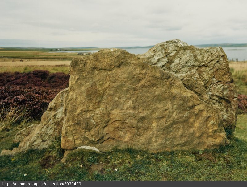
Graffiti has been on my mind a lot recently, prompted by a visit to Machrie Moor on the island of Arran in the summer where we noticed that one of the standing stones at circle 3 had been horribly defaced with a variety of very recent scrapings and markings.

The markings are a combination of scraped words including the F word, sketchy lines, and a hand-shaped zone where lichen seems to have been removed from the stone, perhaps using some sort of solvent or cleaning fluid.

This is as egregious an act of vandalism as I have seen at an ancient monument for some time, and literally a crime. It was also upsetting to see. This is now being investigated by Historic Environment Scotland, and a team have been at the site recently to undertake remediation work.

The tweet above shows recent graffiti at another site in Arran, the King’s Cave, a special place on the west coast of the island that is, ironically, defined by its carvings and graffiti from different eras.

This is not even the first time this has happened recently, with another example at Machrie documented and investigated in 2022. This may have been repaired but was the culprit ever caught? I doubt it or at least I have not heard of this happening.

2022 graffiti (HES / BBC)

A HES blog about heritage crime was in part prompted by an earlier incident at Machrie, and the carving of graffiti on one of the standing stones at the Ring of Brodgar on Orkney.

Archaeologist Joss Durnan at Machrie Moor (c) HES

Repairs are all very well, but as HES stated in 2022, “Heritage crime can cause damage that can never be repaired and forces us to spend less resources on important conservation work.” In the aforementioned blog, they make the stark point: “Once the act is complete, the historic fabric is altered. In the case of incised graffiti, it will never be the same again”.

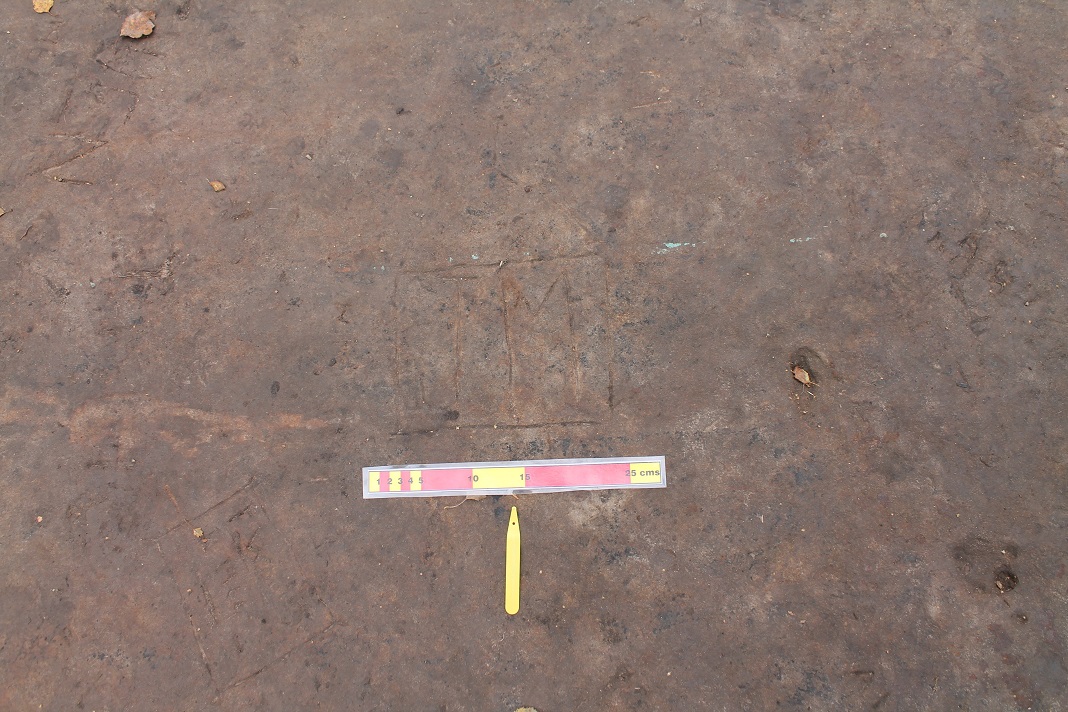
That was very much the case in a shocking prosecution in August 2023 prompted by permanent damage done to a Neolithic rock art panel on Eglwysilan Mountain in Caerphilly, South Wales. In this quite remarkable case, 52 year old Julian Baker had filmed himself for Facebook carrying out a crude excavation of this rock art site, which included damaging the site permanently.

The scene of the heritage crime (c) BBC / Wales News Service

The presence of the white and red ranging rod for scale here (and in other crime scene photo in this blog), so familiar from excavations, is used here to help to document a crime. In this case the rock art section of the panel was detached from the main outcrop. A CADW spokesperson said, “Significant archaeological information has been lost forever, and although some evidence may remain, the significance and value of the part of the monument damaged has been significantly diminished”. Mr Sands received a suspended jail sentence and was ordered to pay £4,400 in damages.

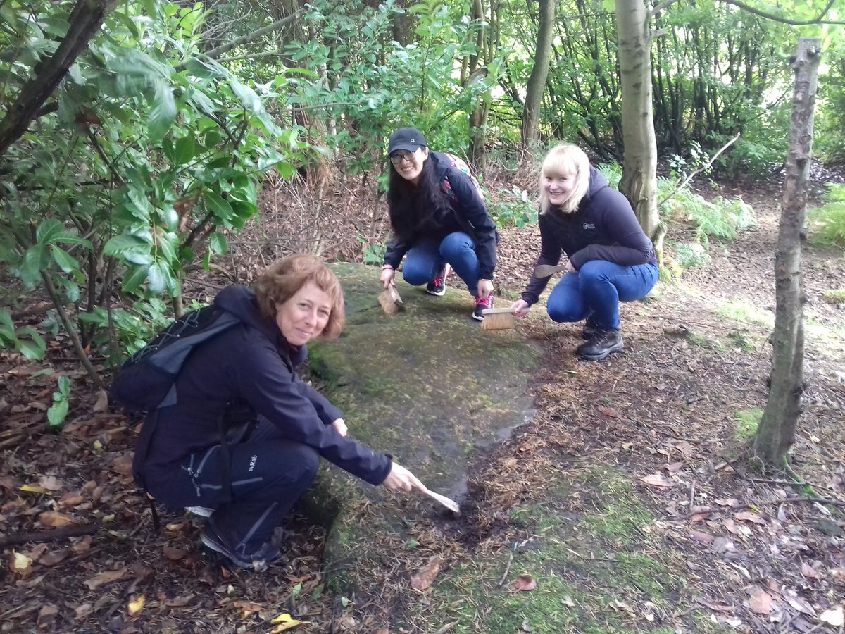
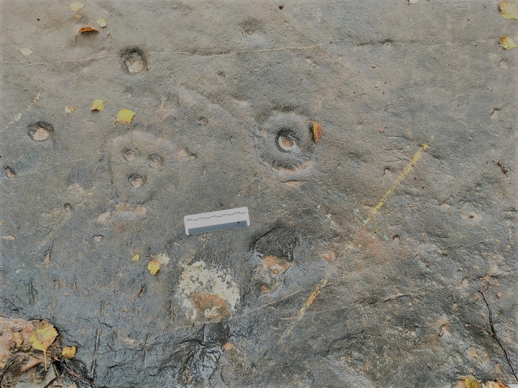
This had slightly uncomfortable echoes of some kind of unofficial excavation that had happened at Stronach Woods rock art panel on Arran when I visited with the Neolithic Studies Group in May 2023. I have no idea if this caused damage or not, but it could have. I reported this to HES and they are investigating.

Vandalism need not be in the form of carvings or crude excavations – take this spray painted standing stone, Maen Llia, in the Brecon Beacons from 2013. There are other examples if you have a google that are less amusing.

So many examples of what we must call the V word – vandalism – coming so close together has made me reflect on my own view of how we value and judge graffiti on prehistoric sites and monuments. Ironically, some of the most recent Machrie Moor graffiti overlies some rather more established carvings, date unknown but not recent. These have become part of the fabric of the monument and have not been erased. In fact, there are lots of examples of (neater) boilerplate Victorian writing on standing stones and megalithic tombs which have become part of the official story of the site e.g. Cuween chambered cairn on Orkney, Blackpark stone circle on Bute.

Graffiti of many types is a surprisingly common part of the fabric of prehistoric sites and monuments. The Ring of Brodgar and Maeshowe on Orkney were both covered in Viking scratchings, and indeed these are celebrated at the latter as a rare insight into informal Norse insults and ephemera. There are cases of modern vandalism of a standing stone carved with Viking Runes at Brodgar, in 2014 and 2015. At time of the latter, local media reported that, “An Orkney tour guide has spoken of his disgust at discovering one of the stones at the Ring of Brodgar has been vandalised this week, by someone scratching initials and a date on one of the stones, in an area close to where Viking runes are engraved”.

Disgust for the 2015 graffiti, celebration and preservation of graffiti carved on the same stones over 1000 years ago. This is not surprising. These Viking runes are significant heritage assets and have been and will continue to be studied; they are part of the historic significance of these Neolithic places, rich evidence of re-use, part of the monumental biography. They were not criminal acts at the time they were carved, although we have no sense of what social conventions were or were not followed at such megalithic sites in Norse times. Taking the act itself, they may have been illicit, taboo, or perhaps no-one cared or noticed.

On the other hand the carvings from last week or five years ago have no particular cultural or social value to us, and as such are in the wrong place at the wrong time. They are the outcome of illegal and illicit acts. I suppose were this to be 500 years in the future, then the initials of some drunk toe-rag carved onto a standing stone might provoke a different response although the long-term cultural significance of HFCH or FUCK is not clear to me.

Recent acts of vandalism at heritage sites can be complex. The repeated repainting of the Cofiwch Dryweryn (‘Remember Tryweryn’) on the wall of a ruined cottage is a case in point. This memorial was first painted in the 1960s to mark the flooding of a village by a reservoir in the Tryweryn valley in north Wales. The wall has been repainted many times, but also defaced, and has become a contested place that some want to preserve and others want to change. In recent years this mural has been defaced with Elvis (in 2019) and a swastika and white power symbol in 2020 amongst other things.

(c) Jez Broughton
(c) Archaeodeath

This is a serious business and here graffiti has become entangled with various different iterations of nationalisms, acts of subversion, and abuse. You can read more about this from archaeologists such as David Howell (chapter in this book) and Howard Williams.

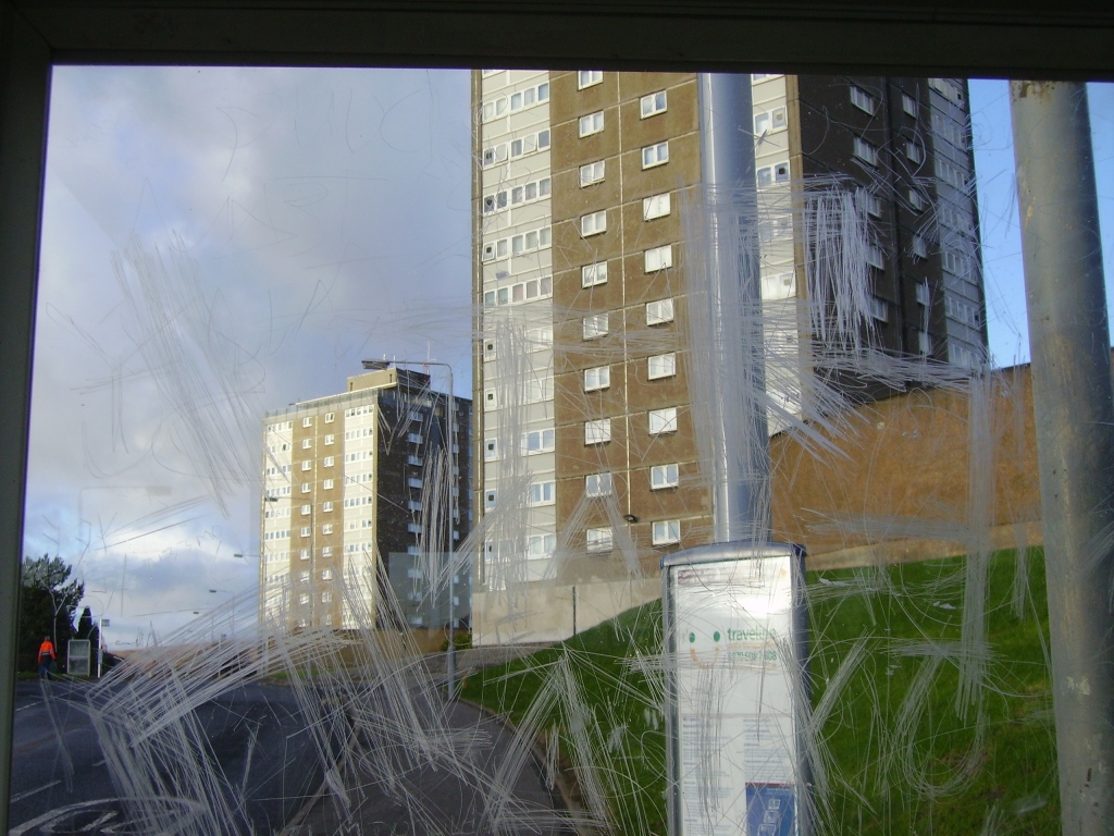
Just this very morning as I write this post, I have been following twitter reaction to the illicit painting of a huge saltire flag on a wall on Cramond Island, near Edinburgh. As archaeologist Gordon Barclay has rightly pointed out, this is a heritage crime.

Many of the responses to this have been couched in nationalist terms downplaying the historic significance of the building that has been defaced. But as Gordon has argued, to what extent does the type of flag painted here cause some to excuse this crime or downplay the heritage value of this place? The V word is very much in the eye of the beholder.

This is illustrated by ongoing discourse about graffiti and damage to ULEZ cameras in London too – vandalism or a legitimate reaction to a political decision? How would the same fringe politicians and right-wing commentators who champion such costly actions react to the carved FUCK on a standing stone? We know how they respond to orange paint being thrown on the window of a bank headquarters. It is clear that the label vandalism is applied to any damage where you disapprove or disagree with the motivation of the perpetrator, which it not necessarily aligned with the law of the land.

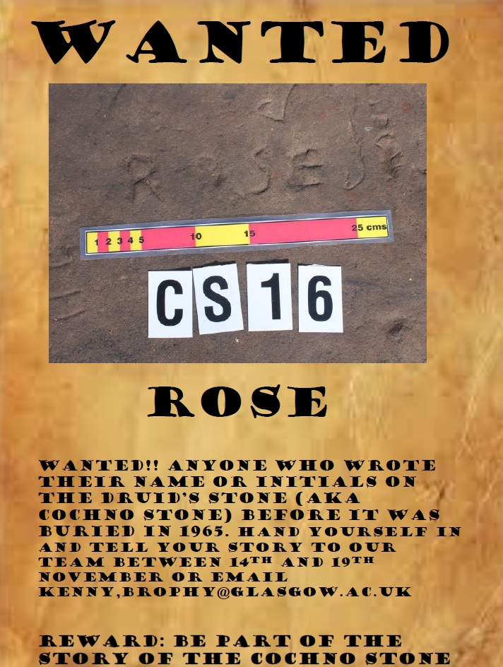
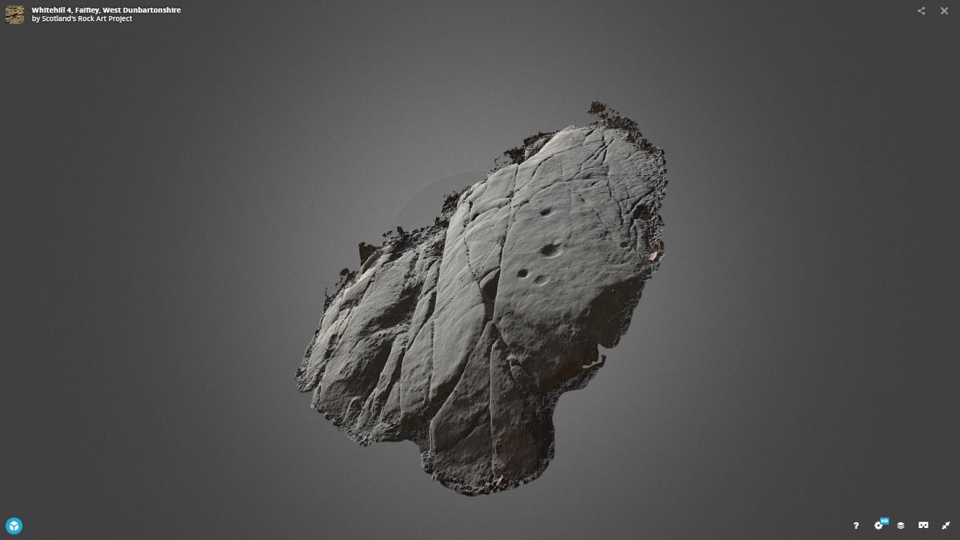
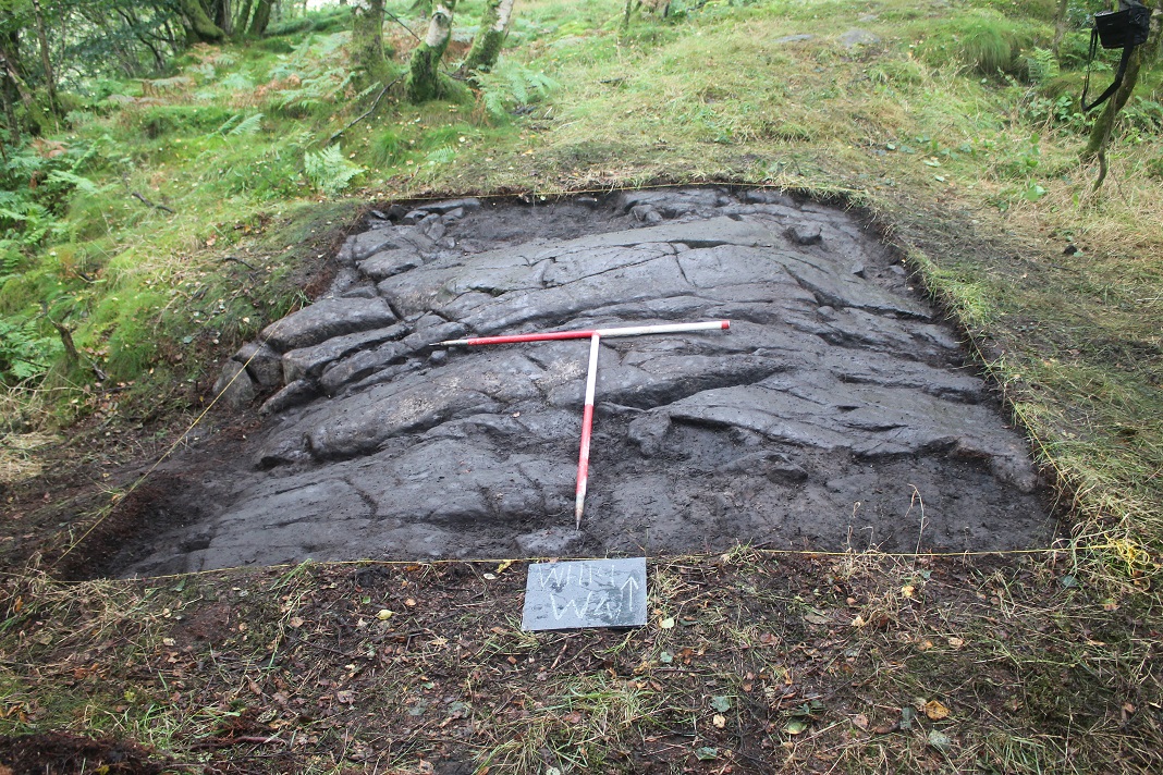
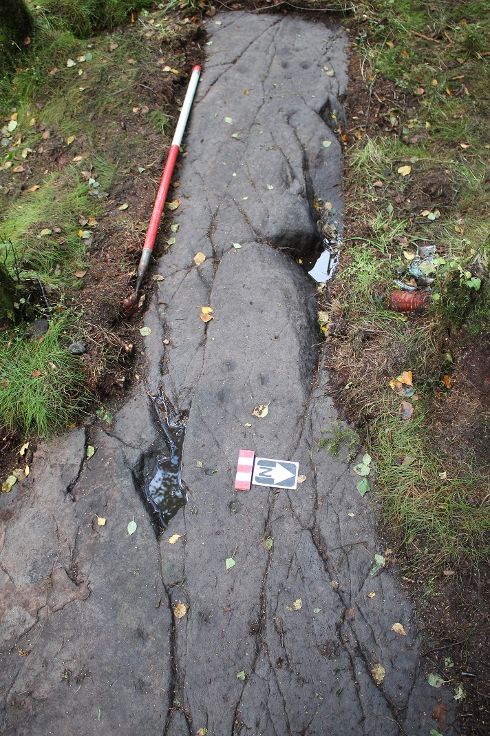
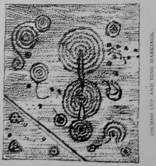
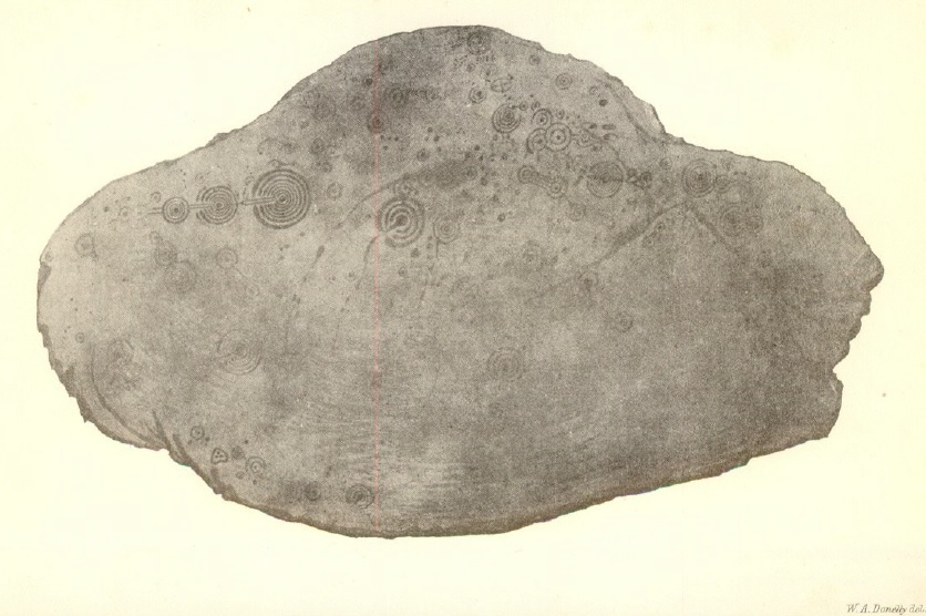
Perhaps where all of this hits home hardest for me is in relation to my own research into the Cochno Stone. In public lectures on this huge rock art panel in West Dunbartonshire I have called this site ‘the most vandalised prehistoric monument in Europe’.

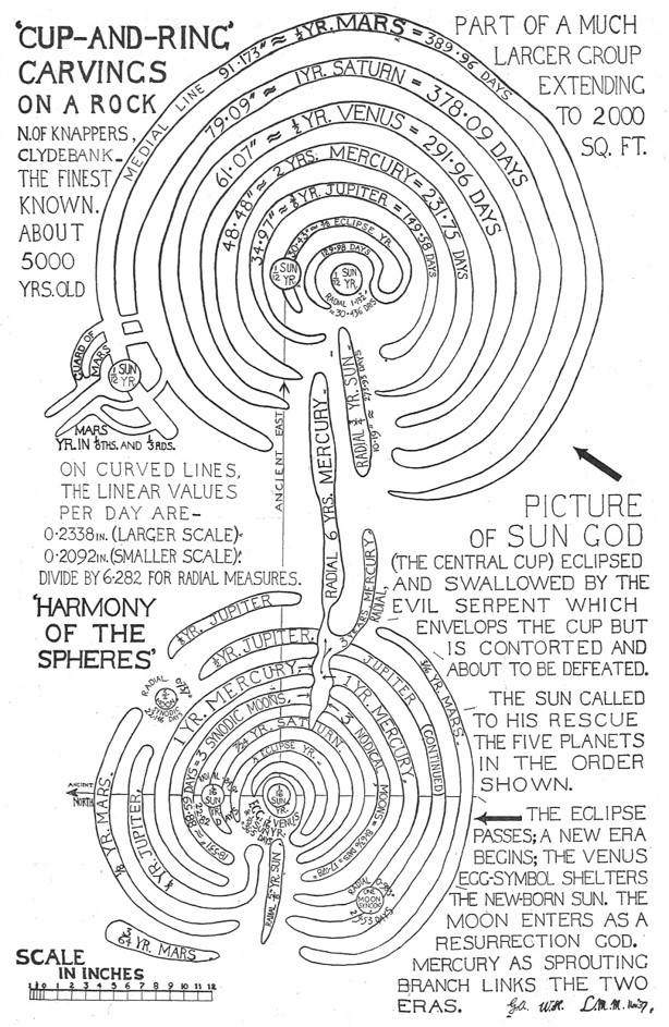
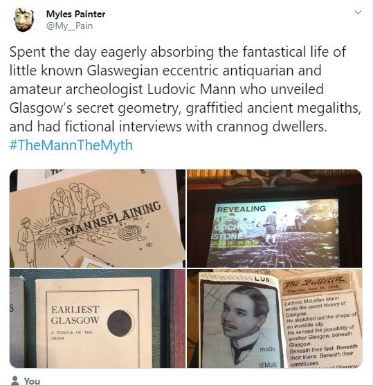
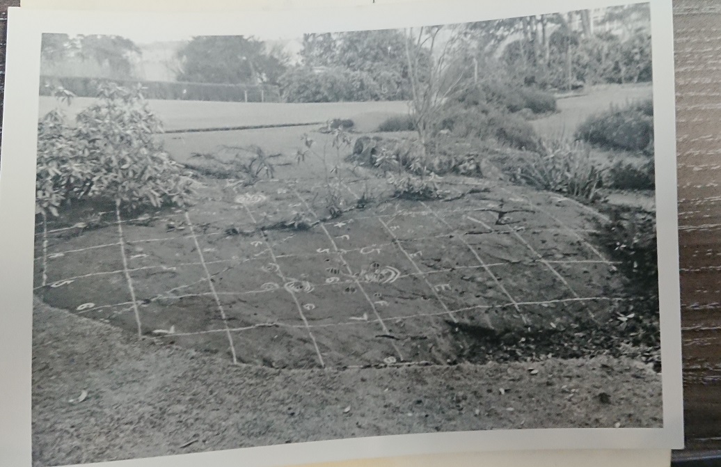
The story may be familiar to some readers. This Neolithic site became something of a tourist attraction after Ludovic McLellan Mann painted the surface of the stone with oil paints in 1937. The prehistoric symbols (and natural marks) were painted white and green, and Mann covered the stone with an elaborate yellow, blue and red grid based on megalithic measurements and cosmological tales of his own devising. This led to the site being scheduled — given legal protection — immediately. However, as more and more visitors came to the site, and urbanisation brought big populations to the area, so the Cochno Stone became an increasing focus for new markings – graffiti – with names, initials and dates scraped onto the surface of the stone. After decades of trying to manage the site, finally it was decided to bury the stone for its protection without any consultation or warning in Spring 1965 on the order of the Ancient Monuments Board (these are my words but taken from this source, yes I am plagiarising myself!).

So this is a site that in the 20th century was covered in oil paints by Mann in 1937 and some 100 piece of graffiti that only ended in 1965 with the burial of the stone. What Mann did was deeply eccentric and probably rooted in his own campaign for respectability. But it was not illegal even if he should have know better. However after the monument was scheduled in 1937 each act of graffiti was a heritage crime in the true legal sense even although my research suggests that many of the culprits were children, and the community had little sense of how significant or old this site was.

Motifs (which themselves may be 19th C additions) pained by Mann (c) HES
Graffiti record from the 2016 excavation
Graffiti and Mann paint from the 2016 excavation

Alison Douglas’s research into the graffiti shows it to be a mixture of initials, names and occasional doodles, of a type that I am comfortable as being viewed as engagements with a place that had a special meaning for a local community. Yet is is also true that we found evidence of other less excusable damage such as remnants of a plastic bag or bucket that was been burned and melted onto the stone, and scuffs from folk walking across the stone constantly.

From my 2015 pilot dig – melted plastic and graffiti

And during the 2016 excavation, one new piece of graffiti was added to the stone. Another heritage crime but one that I did not report or think much about at the time. Would I act differently now? Possibly.

What is the material difference between the 2016 graffiti and a similar set of initials from 1964? Why do I treat the graffiti and paint across the Cochno Stone differently from more recent examples that I have found upsetting? Rock art and the making of marks on stone seems to be especially vulnerable to such modern additions. It is a human desire but is it wrong? In some cases, legally and morally, yes. But not all.

Paint on Craigstone Wood 1 rock art panel, Glasgow (Ian Marshall / ACFA)
Graffiti beside rock art panel at Ballochmyle, Ayrshire in 2014
Chacefield Woods near Falkirk – red paint

I have been treating the Cochno Stone graffiti as if it were Viking Runes in Maeshowe. A cultural tradition that tells us something about a human engagement with an ancient megalith in a very specific place and time that is not now. The motivations for carving on these Neolithic stones were not especially noble – names, dates, doodles, indicative of casual interactions and not grand statements. But unlike the vandalism that this blog post was prompted by, my sense is that the carvers of initials and runes did not have the same motivations as the person who scraped the F word into a Machrie Moor stone.

I had something of as revelation as the graffiti was revealed – I wasn’t angry or upset Rather I was curious. HES historic graffiti expert Alex Hale has captured this feeling well:

“at some point graffiti emerged as a suitable subject to most of us and we realised that this unknown, potentially unruly, or even feral phenomena could open up new research possibilities—including those beyond the academy” (Hale 2022).

So when I started to try to make sense of the graffiti at Cochno, I was careful never to call if vandalism, instead using the term ‘historic graffiti’. I have never been judgemental and have spoken to some adults who carved their initials onto the stone when they were kids. I have tried to be playful about this such as the poster above (something that never saw the light of day as far as I can recall). But I accept that not everyone will see it like that.

There is no temporal cut-off point for when vandalism becomes historic graffiti. Nor should there be. Creative interventions and subversions can be legitimate and illegal at the same time. But we also have to acknowledge that graffiti and the like can be used by bad actors for political, nationalistic and sinister reasons. Some of this might be called ‘mindless’ as is likely how we would characterise damage at Machrie, but this is not always the case. For some, the motivation does matter. Rather amusingly Ludovic Mann went to the media in the late 1930s to complain about vandals throwing red paint over a cup-marked outcrop neat the Cochno Stone; this could charitably be described as mental gymnastics.

Proactively having a motivation to damage a prehistoric monument is not a get out of jail free card. Think about this Extinction Rebellion logo sprayed onto an interior orthostat at West Kennet long barrow in 2019. The world is burning so does anything go? The local ER Group coordinator Bill Janson does not think so: “We heard from the police that someone had sprayed our symbol on the stones, we were horrified and concerned. This act is completely against our principles”.

Photo from Swindon Advertiser

Graffiti and the vandalism of heritage sites is a can or worms because sometimes graffiti can be the heritage, but sometimes it is a heritage crime. This is not always as clear-cut as one might imagine. My own research at Cochno straddles this boundary and so it does no harm to reflect on the words I use and consider alternative views. The F word is almost certainly the V word – but beyond that things can become complicated.

Sources and acknowledgements: thanks to Alison Douglas for her work on the Cochno Stone graffiti and community members I spoke to and thanks also to Alex Hale for many conversations about historic graffiti over the years.

The Hale quote comes from a conference presentation he gave in 2022 entitled Graffiti Some Times: Archaeology, Artefacts and Archives – download.

To find out about Mann’s paintjob at Cochno 1937 see K Brophy 2000 The Ludovic technique: the painting of the Cochno Stone, West Dunbartonshire. Scottish Archaeological Journal 42 [contact me if you want a pdf of this article]

The history of prehistory

One of the little-known pleasures of researching prehistory is excavating archives. This is because the material remains of the past can only tell us so much. Whisper it, but understanding prehistory sometimes requires an engagement with the written word. From antiquarian accounts and field notebooks, to scheduling and planning documentation, to personal archives and media repositories, there is a wealth of information out there that can tells us about the most recent history of even the most ancient of sites. Documents, photographs, sketches, and even letters can be as informative as a nicely excavated posthole or a sherd of Grooved Ware when it comes to forming our prehistoric narratives. Research into any prehistoric site must include consideration of the historic in order to fully contextualise that site.

In his recent book A Contemporary Archaeology of London’s Mega Events (UCL Press, 2022), Johnny Gardner has set out a persuasive case for the methodological toolkit of the contemporary archaeologist to include visits to archives and oral histories, as well as more traditional field skills such as excavation and survey. I would extend this to prehistoric archaeology. Making sense of how a site appears to us now and the range of tangible evidence likely to have survived can only benefit from consideration of historic engagements with these sites; the story of how the site came to be in its current incarnation did not end when the last Neolithic person trudged away at the end of a ceremony. Site formation process documentation is not just about understanding sediments, erosion, or animal burrowing. In the archaeological record nothing stays static for long and humans can’t help themselves.

This post has been prompted by the recent passing to me of some very special photos of the Cochno Stone, a rock art site in West Dunbartonshire that I have been researching since 2015. (Watch this lecture I gave in 2021 for the story so far.) This made me reflect on the journey I have been on searching archives, gathering images, and speaking to people about this site and other rock art panels next to Faifley. I’ve also been doing some writing about this and I’ll update this post with links when they come to fruition. I also did an online lecture on this theme in August 2022 for Kilmartin Trust Museum, which should be available to view here soon.

The point I want to make here is that good prehistory, like any other investigation of the past, can and should happen in libraries, collections, archives and living rooms, otherwise we risk limiting ourselves.

To help make this point I would like to look at photography and the research context for these images. So I’m going to look at two aspects of the Cochno Stone story through the lens of archival material: the painting of the stone by Ludovic Mann in 1937, and events in the years around its burial in 1965.

Material being used here includes the Ronald Morris archive; HES / RCAHMS / Glasgow Life / West Dunbartonshire Council archives; and material held by private individuals. The Ronald Morris archive was my first port of call very early on in the process. Morris was a solicitor turned rock art aficionado, the godfather of amateur rock art archaeology in the UK for many. He was active in the field between the 1960s and 1980s, but he didn’t ever see the Cochno Stone, his first visits to Faifley coming a couple of years after the 1965 burial. I was hopeful though that he might have acquired some photos of Cochno on his visits or through his network of local contacts. So I have spent a couple of sessions looking through his extensive and largely uncatalogued archive held by HES at John Sinclair House in Edinburgh.

The archive contains a series of record pockets, one for each rock art site in Scotland. The Faifley record cards are a treasure trove of information on the sites at Auchnacraig and Whitehill with photos, sketches, fieldwork notes, letters and so on, most of which did not make it into Morris’s publications. Other sources of material will be introduced below.

Morris archive material (top) Auchnacraig 1 file, (bottom) Cochno Stone aka Whitehill 1

Clearly significant archaeological events such as those discussed in this post should be documented well, one would think. But in fact, they are not. There are many photos of the Cochno Stone – try googling it – but in fact these have rather limited scope and tend to fall into one of two categories. There are a tranche of black and white photos that probably date to the years immediately after Mann painted the stone in 1937. These photos tend to show parts of the site, which has been helpful in making sense of the detail of Mann’s paintjob although some areas of the stone have never quite been captured.

The other type of photo are from the time of our excavations at the site in 2016, when the whole stone was uncovered for 10 days. Some of these are ‘official’ photos as it were, taken by me and other team members, and then shared online. Others were taken by visitors to the site, while there is some officially sanctioned HES photography on the canmore page for the site including images taken by their high-spy piece of kit. (This has over 50 photos of the site, a great cross section and well worth checking out.)

But I have been aware for several years that there are gaps in the photographic record for this monument. There are, so far as I can tell, no photos that have come to light yet that show the Cochno Stone before Mann painted it. We only have sketches from the half century between ‘discovery’ in the late 1880s and 1937. Until recently there was only one photo I had seen of the stone actually being painted. And there is real dearth of imagery from the period in the run-up to the burial of the stone in 1965 – a time when one would presume based on our excavation observations that the stone was at least partially grown over and Mann’s paint had largely faded into memory. So we have really good photographic coverage from 1937 to 1950, and 2016, but almost nothing between 1888 and 1936 or 1950 and 1965; clearly between 1965 and today the stone has been buried and beyond the realm of photography for all but a fortnight.

There is a real research imperative to tracking down photos from these gaps in our coverage, as these would, one hopes, shed light on the, say, the process of painting, and the changing condition of the stone through time. So I have spent quite a bit of time searching in archives for photos that might fill these time gaps, and I’ve also been fortunate enough to be passed photos and slides from others who know of my research interests. This has allowed the gaps to gradually be filled albeit it slowly and in limited quantities. However when a new photo comes to light it is almost always a thrill, but often poses more questions than it answers. This also catalyses further research, whether that be returning to the excavation archive itself, or going to a library.

Paint: 1937

When I started work on the Cochno Stone, finding out more about the painting in 1937 was a primary aspiration. The painting of the stone by Ludovic Mann and with help from George Applebey is one of the defining moments in the biography of this monument. Notes in Mann’s own archive so far have revealed only circumstantial evidence for what Mann did and why he did it. Speaking to George Applebey’s son, also George, also revealed little on what happened in that summer of 1937. Mann’s work at Knappers / Druid’s Temple that summer completely overshadowed his time at Cochno, to the extent that almost no newsclippings could be found that even showed the paint never mind reported on the event. This is surprising as Mann was very much an influencer and serial media user at the time, as I have written about elsewhere. My attempts to work out what Mann was up to can be found elsewhere (Brophy 2020). Suffice it to say that this eccentric act has in its origins in Mann’s obsessions with prehistoric eclipses, cosmology and metrology.

The actual act of painting, which must have taken quite some time and been very complex, is even trickier to make sense of due to a lack of documentation. One photo in the public domain supposedly showed Mann himself painting the stone. This was published in Ronald Morris’s 1981 book The prehistoric rock art of southern Scotland (except Argyll and Galloway). The caption for Plate 111 notes, ‘L. M. Mann painting in the carvings about 1937’ and the photo was taken from the J Harrison Maxwell collection.

This doesn’t really look like Mann is painting (is it even Mann?) so this is probably a posed shot once the job has been completed and this is certainly one of the most detailed photos of this feature of the site. It reminds me of a rather better-known image, again probably posed by Harrison Maxwell, this one featuring Mann and Applebey. This digital version held by HES was scanned back to front by RCAHMS for some reason, the correct version is also included for reference.

Canmore_image_SC01062363

During preparation for The Mann the Myth conference in Glasgow in 2019, Glasgow Life curator Katinka Dalglish passed me a photo she had found in the Mann archive they hold that does actually show someone painting the surface of the stone. At first I assumed this was Mann himself but his hair is not the same as the chap who is definitely Mann in the above photo. Here coloured paint is being applied (probably red, maybe blue) using a course brush and messy paint tin. The stones and white sheet / paper may relate to a rubbing being done of the stone at the same time.

Glasgow Life

Then in May 2022, I was emailed a selection of scanned photos. These photos had been sent to a Mrs Bowie of Clydebank by Ronald Morris in 1979. In turn these had been passed to committee members of the Clydebank Local History Society, Dave Carson and then Sam Gibson. It was Sam who kindly sent me the scans. One of these immediately blew me away: another paint job shot.

This remarkable photo shows another team member – a woman this time – working on the stone, probably painting a cup-and-ring white. Here, the paint tin is clearer, with some on twitter suggesting this might be Crown brand. A brush sits beside the paint, and the brush is slightly less coarse than the one branded by the unknown man above. This suggests that painting the stone was more of a team effort than I had initially presumed. But who are these members of the painting team?

One last look: 1964

The Morris archive contains a folder for the Cochno Stone (aka Whitehill 1). It is disappointingly thin (as he did not actually see the site) but did contain some fascinating photos from 1964 and perhaps 1965.

There are tantalising notes and photos regarding a 1964 excavation carried out by the University of Glasgow’s Horace Fairhurst. This is accompanied by an incredible series of photos showing four middle-aged men on a large rock surface, examining the stone and even lifting flaps of carpet-like turf expose the symbols beneath. There is some confusion in the published work of Morris and his notes as to whether this is actually the Cochno Stone or a neighbouring site that has since been ‘lost’.

What the third of these photographs clearly show is that the Cochno Stone was by 1964 apparently largely free of the paint that Mann had applied, this having weathered away after almost 30 years of exposure to the elements. This photo also shows quite clearly that the edges of the stone had begun to grass over, something we had suspected during the 2016 excavation. The stone was stained on the fringes and the paint survived, suggestive of these areas of the monument having been protected from weather to an extent.

Yellow paint lines from 1937 survived probably due to being grassed over by the 1960s

So far I have been unable to find any written record of this piece of fieldwork or established the nature of what Morris called an excavation at this time. Horace Fairhurst (1908-1986) was a geographer cum archaeologist, and the first head of Archaeology Department at the University of Glasgow in the 1960s (a post I currently hold). His most significant research related to medieval and post-medieval settlement in Scotland and the archaeology of the island of Arran. This may well have been an opportunistic piece of work carried out at the request of Morris, and seems to have been at most ‘having a good look’ at the site.

Horace Fairhurst (looking to camera) at Machrie Moor, Arran, in 1979 (source: Demarco Digital Archive)

Very recently another set of photos came into my possession that were taken around the same time, perhaps even during this fieldwork episode. My colleague Nyree Finlay found a small number of slides showing rock art sites within the archive of our now sadly deceased colleague, Alex Morrison. Two of these slides were taken of the Cochno Stone in 1964 and crucially are in colour. These photos have presumably never been seen outside the lecture theatre – until now. I am not sure if these photos were taken by Alex – he graduated in 1964 and so may have accompanied Fairhurst on a visit to the site as they shared rural settlement research interests. Unlike the black and white photos above, here the scale is a shooting stick, rather than a measuring tape.

These stunning images are very helpful in understanding what the Cochno Stone looked like in 1964, less than a year before its burial. Grass and weeds have encroached onto the fringes of the outcrop. Almost no traces of Mann’s paint survives. But perhaps most noticeably, the surface appears covered in scrapes and scratches of the kind one might associate with a lot of people walking on the stone and in some cases marking it: some letters are visible scraped into the stone surface as well as hints of the more deeply incised graffiti we found in 2016. The wall surrounding the stone seems almost ruinous in places with parts of this lying in weeds around the stone although the style survives on the north side. Finally, there is apparently a fence around the entirety of the stone, something I had previously not been aware of.

Within months the stone was buried. Perhaps this brief interlude of interest in the Cochno Stone by some archaeologists from the University of Glasgow was instrumental in the burial, or the visit occurred for the purposes of documentation before the the stone was covered over. This has yet to be established.

The Morris archive includes another significant image which seems to show the location of the Cochno Stone not long after it was buried. The triangular feature on the skyline is part of a metal fence atop the wall around the Cochno Stone and so this picture seems to have been taken from the south-south-west. Rubble or wall remnants appear in the foreground. If this photo was taken by Morris is might have been on a visit to the area in 1968; not all of the stone appears to have grassed over however at this time. Another note: this image seems to be from a proof, but was this photo ever published?

Concluding thoughts

The photos and records I have been fortunate enough to consult over the past few years have been transformative in my understanding of the 20th century story of the Cochno Stone. Yet even for the recent past gaps in knowledge and understanding remain, gaps that to an extent can be filled by talking to people and learning from their memories and experiences. Taken together, these very historical means of knowledge generation – archives, files, photographs, interviews – can help us to piece together the modern biography of prehistoric sites and their study. In turn, this final piece of the biographical narrative of such sites that stretched back thousands of years can be more fully understood. And the last chapter is almost always essential reading in any book for a good reason.

There is much more to unpick here. More photos and files remain to be consulted, and there are people to speak to. Excavating this kind of knowledge will probably be more useful in helping us to understand Faifley’s rock art than anything I could do with a trowel or a microscope. These are human stories, regardless of whether they were being written in stone 5,000 years ago or in 1937, or 1964. So my plea to prehistorians is – look to history!

Sources and acknowledgements: I would like to thank the staff of the HES search room for looking out the Ronald Morris archive for me to consult. Thanks also to Katinka Dalglish, Nyree Finlay and Sam Gibson for providing me with some of the materials discussed above. Thanks very much to Michael Gannon for scanning the Morrison slides for me.

I have written a chapter on Ronald Morris’s archive in a book published to celebrate Stan Beckensall’s wonderful life and career in September 2022. The book is being edited by Kate Sharpe and Paul Frodsham and my chapter is called: Digging into the Ronald Morris archive: a Kilmartin Glen case-study. Full details as soon as I have them.

The other reference in the text relates to my own writing on Mann’s paintjob in 1937: K Brophy 2000 The Ludovic technique: the painting of the Cochno Stone, West Dunbartonshire. Scottish Archaeological Journal 42 [email me if you want a pdf of this article]

I also appreciate the invite to speak as part of the Kilmartin House Trust lecture series in summer 2022. The topic was using the Ronald Morris and Ludovic Mann archives. There was a great and well-informed audience of almost 90, and Ken McElroy created this disturbing image to market the talk. It must have worked!

Faifley Rocks WH19

This is a summary account of the excavations at Whitehill 3, 4 and 5 rock art panels between 13th and 19th August 2019. This report was written with co-director, Yvonne Robertson. This is a brief and provisional account, with a more detailed publication to follow in the future.

zines
Zines inspired by the excavations, created by University of Glasgow archaeology students

Faifley Rocks! is a project researching prehistoric rock art sites to the north of Faifley, Clydebank, West (and as it turns out East) Dunbartonshire, using excavation, survey, oral history and archival research. The largest rock art site in the area, the Cochno Stone, has received the most attention, but sits within a small group of c 16 rock art panels. Some of these sites were identified in the late nineteenth century, others through more recent fieldwork, but no comprehensive work has been done on any of these sites since Ronald Morris’s fieldwork in the 1960s and 1970s (reported on in Morris 1981).

This was the second excavation as part of the project, following work at Auchnacraig in June 2019. The summary report of this excavation includes some more background on the project which need not be repeated here.

Whitehill 2019 excavations

In August 2019, excavation took place around three of the rock art sites in the area, sites known as Whitehill 3, 4 and 5 in Scotland’s Rock Art Project (ScRAP) database. These outcrops are situated within a small area of woodland amidst arable fields immediately to the northeast of Whitehill Farm and north of Law Farm on a prominent landscape position with extensive views to the south. The outcrops are sedimentary, being gritstone or sandstone. They are located around NS 5138 7403 and are listed in canmore. These are just inside East Dunbartonshire and hence not quite on the map below right!

WH19 location map

location map
Red circle = Whitehill 3-5 location. Green circles = Whitehill 1-2 and 7 locations

Two of these sites were first recorded in the 1960s by Morris unlike the Auchnacraig sites which were first documented in the late nineteenth century. Morris documented these in his 1981 book The prehistoric rock-art of southern Scotland (except Argyll and Galloway). The numbering system he used is slightly different to the system adopted here; we are adopting the ScRAP nomenclature.

Whitehill 3 is the most extensive of the panels and located on the edge of an escarpment. Morris called this site Whitehill 5. It was initially briefly documented in the Morris and Bailey gazetteer (1967, 161) as a hilltop or break of slope location decorated with 25 cups and a few cups-with-rings. This is reflected in a sketch that is within his archive at HES (see below).

In 1971, Morris uncovered an area some 10m by 10m (although his plan suggests a smaller area was looked at) and found more symbols. He recorded, ‘5 cups-and-two-rings, at least 21 cups-and-one-ring, and at least 40 cups. Radial grooves were noted in some instances, and dumb-bell shapes identified’ (1981, 130).

IMAG3963
Sketch in Morris archive from 1960s showing the area of this rock that is typically visible (Image sourced by Denise Telford)

Morris plan of WH3
Morris’s drawing of Whitehill 3, published in 1981, based on a more energetic clearing of vegetation from the outcrop during a visit in 1971

IMAG3966
 Morris photo of Whitehill 3 presumably during the 1960s visit (Photo sourced by Denise Telford)

In March 2019, these panels were subject to detailed recording and photogrammetry as part of SCRAP. RTI survey of Whitehill 3 was also undertaken by a team from Glasgow School of Art. The SCRAP record for this site notes that 22 cupmarks, 13 cup-and-ring variants and 7 grooves were recorded; the latter are distinctive oblong cupmarks that the record sheet calls ‘courgettes’. An enigmatic graffiti symbol was also noted; this had been pointed out to me on previous visits. Connections between symbols and ‘fissures’ were noted.

Whitehill 3 model screengrab
3D scan of Whitehill 3 (c) HES / ScRAP

WH3 during 3D recording March 2019
Setting up for RTI recording of Whitehill 3 in March 2019 (photo: Alison Douglas)

Stevie rock-art low res
Another part of the Whitehill 3 panel usually covered by vegetation, on a visit in 2018 with Stevie Cafferty

During the SCRAP and Glasgow School of Art surveys, the site now called Whitehill 4 was discovered c20m to the south. This is described in the SCRAP Project database as a ‘domed sandstone outcrop’ that has four cupmarks, one of them dubious. Morris noted additional cupmarks at Whitehill but did not formally document them; this is probably one he spotted and referenced (1981, 133).

WH4 March 2019
Whitehill 4 photographed after recording in March 2019

WH4 3d scan screengrab
3D scan of Whitehill 4 (c) HES / ScRAP

The third panel in this location, 25m south of Whitehill 3, is known as Whitehill 5 in the SCRAP database. The survey in March 2019 identified seven cupmarks on this stone, which was entirely covered in turf at the time.

WH5 in March 2019
Whitehill 5 during recording in March 2019 (photo: Alison Douglas)

WH5 screengrab
3d model of Whitehill 5 (c) HES / ScRAP project

It is not clear if this is the same as Whitehill 6, a site was first recorded by Morris during the visit to the location in 1971 already noted above, having been found by a JM Stables (Morris 1971; 1981). Morris noted that the rock was carved with a ‘much-weathered cup-and-two-complete-rings, slightly oval’ (1981, 133) and suggested it was 55m south of SCRAP Whitehill 3. This site appears similar in Morris’s Plates 123 and 125 (see images below) but the presence of a clear cup-and-ring mark, and its location info, suggests this is a different panel.

Morris Whitehill images

Objectives: August 13-19th 2019 excavation

The specific research questions for the excavation of these three panels were:

  • Do carvings extend beyond the currently exposed outcrop?
  • What evidence is there for activity in prehistory, and in the twentieth century?
  • How do the panels physically and spatially relate to one another?
  • Are there any other carved stones in the vicinity? Morris noted others that are not accounted for in the SCRAP survey eg Morris’s Whitehill 6 and 7.
  • Is there additional historic graffiti on the rock art at Whitehill?
  • What is the significance of the location of these sites eg in relation to views and other rock art such as Law Farm sites and SCRAP Whitehill 1-2?

Methodology

The excavation was conducted between the 13th and 19th August 2019 by Glasgow University staff and students, and local volunteers. Upon arrival, the area was subject to a visual inspection to ascertain the condition of the outcrops containing rock art and any further possible features and archaeological remains.

Essentially we ended up clearing vegetation from the outcrops rather than excavating the surrounding area due to the extensive nature of the bedrock.

Cleaning low res

Three ‘trenches’ were laid out focusing on the exposed outcrops at Whitehill 3, 4 and 5. Seven small test pits were also excavated (all but one measuring 1m by 1m) which were positioned in the surrounding woodland targeting areas of archaeological potential both on the ridge and in the valley below. The trenches and test pits were all hand dug, with contexts and rock art being recorded in plan and section, as appropriate, by measured drawing, digital photography, and written descriptions on pro forma sheets. Photogrammetry was also conducted on all three exposed rock art outcrops. After excavation and recording the excavated material was replaced and the turf reinstated.

sketch site plan
Sketch map showing the locations of the three trenches and test pits 1-7. Base map is OS 1st edition.

Results

Trench W3

Trench W3 aimed to investigate the largest of the three known Whitehill rock art sites, Whitehill 3, where a number of cup marks were already visible on an exposed outcrop of bedrock.

A trench measuring 5.0 m by 5.0 m was opened over the exposed outcrop and the flat top to the west and north covered with a shallow layer of turf and topsoil. An extension measuring 2.5m by 1.0m was opened to the west of the trench as well as an extension to the north-east measuring approximately 2.5 m by 2.0 m in order to investigate a wider area for potential rock art symbols. Turf was also cleared off the steep slope of the outcrop to the east in order to investigate the potential for further symbols.

WH3 low res a

Where present, the topsoil comprised a shallow layer (0.15m) of loose medium to dark brown silt loam (context number 301/303) which contained modern glass, plastic and metal as well as a small quartz pebble (Find 1) recovered from a crack in the bedrock. The topsoil directly overlay the natural bedrock (300) in the majority of the trench although pockets of a medium orange brown silt clay with infrequent small pebble inclusions (302) and a medium dark grey silt clay with frequent angular stone inclusions measuring 0.05-0.10 m (304) were recorded in pockets across the trench within natural fissures in the bedrock. This material was relatively sterile and was interpreted as natural hill wash. Disturbance caused by tree roots was apparent throughout deposits across the trench.

WH3 low res b

Bedrock (300) was encountered across the entire trench. The bedrock was a large flat-topped sedimentary outcrop which sloped steeply downwards to the east and gently sloped to the north, west and south.  Up to 65 carved symbols, including c. 33 cupmarks, 16 cup-and-ring marks, six cup-and-ring marks with double rings, eight oval/elongated cupmarks or grooves and at least two radials, were recorded within the trench, largely concentrated on the flat top of the outcrop (see photos). The symbols were of varying size, depth and quality, and dispersed in no clear pattern across the outcrop, and some had clearly been weathered as a result of having been exposed.  Large natural cracks where the bedrock had fragmented in parts were visible across the surface in a north-east to south-west orientation and these areas were devoid of markings. A graffiti symbol was also recorded on the bedrock (300) where the rock had previously been exposed; the meaning of this symbol remains unknown.

graffiti on wh3 low res
Graffiti on Whitehill 3. This might be upside down! 10p for scale.

Trench W4

Trench W4 measured 4.0 m by 3.0 m and was centred on a bedrock outcrop to the south-west of Whitehill 3 known as Whitehill 4. Prior to excavation, four cupmarks were visible on the bedrock outcrop and the trench aimed to investigate whether further symbols were present as well as whether any further archaeological features were present in the area surrounding the outcrop.

Context 405

The trench was largely covered by topsoil (401) comprising a friable dark black brown clay loam with occasional angular stone inclusions (measuring 0.05 – 0.20m) as well as rare charcoal flecks. Modern glass and plastic as well as a post-medieval or modern ceramic fragment (SF 2) were present within the topsoil. The topsoil directly overlay bedrock (400) in the centre of the trench, however, an underlying clay silt wash comprising dark brown clay silt with occasional angular stones and frequent charcoal (402) was recorded in pockets of the trench within undulations in the bedrock (400).

WH4 after first clean
Whitehill 4 after initial cleaning. Greasy silty dark brown (402) in patches visible across the trench, these presumably washed into cracks in the rock.

This deposit also overlay what initially appeared to be a rubble stone wall comprising angular stones (measuring 0.08m – 0.30m) in the north-west corner of the trench. Further rubble material was encountered to the immediate east of this within a large sub-rectangular depression (404). Fragmented bedrock as well as other fragmented stone within a grey silt wash matrix similar to (402) filled the depression and may have been a leveling deposit within a natural hollow, purposefully placed for a platform or trackway or naturally occurring.

WH4 stone cluster
Mid-excavation view of possible leveling deposit from the west

To the south of the Whitehill 4 outcrop, a clean light grey sand was recorded below (402). The material was sterile and appeared to have been a naturally washed in deposit directly overlying the bedrock.

W4 plan

No further symbols were observed on the bedrock (400) nor were any further archaeological features recorded in the surrounding deposits.

Trench W5

Downslope and to the south of Whitehill 4, a trench measuring 2.0 m by 0.5 m with a roughly rectangular extension to the south-east measuring 2.5 m by 2.5 m was excavated. The trench focused on an outcrop recorded as Whitehill 5, previously exposed by SCRAP, where three cupmarks were visible on the exposed outcrop prior to the removal of any material. Topsoil (501) was found to extend across the rest of the trench and comprised a friable medium orange brown silt loam with extensive root disturbance and organic material and generally had a depth of 0.10m. The topsoil directly overlay bedrock in much of the trench although a silt clay wash deposit (502) formed a subsoil between the topsoil (501) and the bedrock (500) in the east of the trench. This material was largely sterile and there was clear root disturbance.

WH5 during planning
Trench W5 during planning

WH5 cupmarks
Cupmarks on Whitehill 5 (the only previously recorded ones are those immediately next to scale and N arrow)

In addition to the cluster of three previously recorded cupmarks associated with Whitehill 5, a further seven possible cupmarks were observed approximately 1.5 m east on the same bedrock outcrop (500) (Plate 7). These were recorded to the east of a large sub-circular area of conglomerate within the bedrock (500). No further features were encountered within the trench and no small finds were recovered.

Test-pits

Seven test pits were opened in all, all bar one measuring 1m by 1m. The location of these is shown in the general site plan above.

Test Pit 1

Test Pit 1 was located at the most northerly point of the ridge on which Whitehill 3, 4 and 5 were situated, c. 45 m north of Trench W3. The test pit targeted this area as it was the highest point on the ridge and found to be relatively level with views of the landscape extending south-east towards the Clyde Valley and to the north-west towards the Kilpatrick Hills. The test pit measured 1.0 m by 1.0 m and was excavated to a maximum depth of 0.30 m.

Topsoil extended across the entire test pit and comprised a friable dark black brown silty loam with occasional angular stone inclusions (0.02m – 0.08m in size) (1001). The topsoil was rich in organic material with some root disturbance. Frequent glass was encountered within the deposit. Beneath the topsoil, medium orange brown clay silt with occasional stone inclusions (1002) was recorded which extended to a maximum depth of 0.20m. This overlay the bedrock (1000) which had an undulating surface within the test pit and sloped downwards from west to east.

No symbols or archaeological features were observed in Test Pit 1, nor were any artefacts recovered.

Test Pit 2

Test Pit 2 was located c. 24 m to the north-west of Trench W3 in a relatively flat area, devoid of turf and simply covered in organic woodland debris. The test pit was placed in this location to determine if there were any archaeological features within this area which could be related to the rock art sites to the south. The test pit measured 1.0 m by 1.0 m and was excavated to a maximum depth of 0.35 m.

TP2

A friable medium black brown silt loam with occasional angular stone and rare charcoal inclusions formed the topsoil (2001) within the test pit and continued to a maximum depth of 0.10m. Modern activity in the area had clearly occurred as glass and modern metal cans were observed throughout. A firm medium orange brown sandy silt with frequent small roots and rare small angular stones formed a natural subsoil (2002) beneath the topsoil and this directly overlay the bedrock (2000). The subsoil deposit was relatively sterile, although some charcoals flecks were noted likely as a result of surface burning and root bioturbation.

No significant archaeological finds or features were recorded.

Test Pit 3

Test Pit 3 was situated c. 7 m north-west of Trench W4 in the centre of a shallow sub-circular hollow. The hollow, although appearing natural, was thought to have archaeological potential and the trench was situated within it to investigate whether features may be present within the area. The test pit measured 1.0 m by 1.0 m and was excavated to a maximum depth of 0.20 m.

TP3
Eric and Ross working on Test Pit 3

An organic vegetation layer (3000) covered the test pit and overlay topsoil comprising a loose light brown organic loam (3001). Beneath this, a natural subsoil comprising a clay silt wash (3002) was observed which continued to a maximum depth of 0.19m which contained patches of compact orange disintegrated sandstone (3003) and overlay the undulating bedrock (3004) (Plate 8).

TP3 sketches

There were no traces of significant archaeological remains within the test pit.

Test Pit 4

Test Pit 4 was positioned c. 5m south-west of W3 and targeted a partially exposed outcrop of bedrock. The aim of the test pit was to investigate if further unrecorded rock art symbols were present on smooth outcrops in the immediate area. The test pit measured 1.0 m by 1.0 m with a maximum depth of 0.10m.

A small outcrop of bedrock (4001) was already exposed and only shallow topsoil was found to cover the bedrock in all areas of the test pit. The topsoil comprised friable dark black brown silty loam (4000) and modern glass fragments were observed throughout. There was no evidence for archaeological features within the excavated area and no markings were observed on the bedrock which was found to be undulating.

Test Pit 5

Test Pit 5 was located c. 5m east of W5 at the southern extent of the site. The location was chosen as it appeared to be a flat area with the potential for a bedrock outcrop to be directly beneath the turf topsoil. The test pit measured 1.0 m by 1.0 m and was excavated to a maximum depth of 0.30 m.

TP5

The topsoil comprised a shallow loose light brown organic sandy loam (5000) which overlay a very compact light brown sand with frequent angular stones up to 0.25m in size. Beneath this a compact layer of dark brown black sandy silt with some large angular stone inclusions was observed (5002). No significant archaeology was recorded within the test pit.

Test Pit 6

Test Pit 6 was located approximately 22 m west of W4 within a level area in the valley below the ridge. The test pit was excavated to investigate whether there were any features associated with quarrying activity in this area. The test pit measured 1.0 m by 1.0 m and was excavated to a maximum depth of 0.50 m.

The topsoil (6000) comprised a dark red brown silty loam which contained modern glass. This was overlying a light red brown clay sand with angular and rounded stone inclusions of various size (6001). Bedrock was not reached within the test pit. No archaeological finds or features were recorded within the test pit.

Test Pit 7

Test Pit 7 was located c. 21 m west of W3 within a slight hollow on the west edge of the ride. The test pit targeted a supposed flat-topped bedrock outcrop and was also located within this area to investigate the potential for features related to the occupation of the site. The test pit measured 1.50 m by 1.50 m and was excavated to a maximum depth of 0.20m (Plate 9). Peck marks on the flat bedrock surface were identified and probably related to someone trying to get purchase on a tent peg…..

TP7
Jean planning Test Pit 7

Modern peck marks
Probably modern peck marks found within Test Pit 7 on flat bedrock

Photogrammetry

Under the guidance of Megan Kasten, teams of students undertook photogrammetry of the three outcrops, which supplemented work already undertaken by SCRAP. In each case more of the rock was exposed than during this earlier survey, and in two cases (W3 and W5) more symbols were exposed as well. These models are still being worked on and final versions will be added to this post, or linked to, in due course.

WhitehillLowerCupmarks Cluster 2
Initial render of results of W5 photogrammetry

Whitehill501lowres
The complete survey of W5, again at early stage of processing

Discussion 

The excavations at Whitehill have shed further light on three of the known rock art panels at Whitehill. Previously unrecorded symbols were observed and recorded on both Whitehill 3 and Whitehill 5, as parts of the outcrop previously left covered by Morris and SCRAP were exposed, and the areas around the outcrops also investigated.

Whitehill 3 was found to be the largest and uppermost decorated outcrop with a huge number of symbols observed on its flat top and the top of the smooth slope on the eastern side. A wide variety of symbols were recorded with no obvious pattern deciphered. The mixture of type, depth and quality does, however, potentially suggest the rock art was conducted by different people at different times. This is the second most extensive rock art site in the area after the Cochno Stone. The rock art panel known as Whitehill 4 was occupied by four simple cupmarks only while up to 13 single cupmarks were recorded as part of Whitehill 5. There is no evidence as of yet to allow interpretation of the relationship of the individual panels or to either confirm or deny that these cupmarks are contemporary with one another as no datable material was recovered in or around the outcrops.

The symbols on all three panels were limited to areas of smooth bedrock enclosed by glacial striations, with only the best areas for carving having been selected. It was also noted that the symbols were largely limited to the top of the flat-topped outcrops with few symbols on vertical faces. Several other rock outcrops were investigated on the ridge to determine whether other panels were present in the area, however, none were found. The shape and aesthetics of the natural rock surface therefore appear to have played a major role in the selection of the outcrops as well as potentially the design of the carvings, a notion also apparent at Hunterheigh Crag, Northumberland (see Waddington et al 2005).

While the areas around the panels were investigated, few further archaeological features were observed. The only notable feature was observed in Trench W4 focusing on Whitehill 4 where an area of fractured bedrock was found to potentially signify the remains of a wall or leveled area. This feature may be related to prehistoric use of the site, with ‘rubble platforms’ having been found to be contemporary with carvings at Copt Howe (Bradley et al 2019) and also, interestingly, at nearby Auchnacraig 1; however, it could also be a result of later quarrying or landscaping activity in the area. No material was found within the cracks on any of the outcrops despite investigation, based on the results of rock art sites such as Torbhlaren, Argyll and Bute (Jones et al. 2011). The quartz pebble found in W3 was in an area removed from the carvings and more likely ended up there through natural processes.

Later use of the area was noted with the west side of the ridge having visibly been quarried and more recent graffiti observed on Whitehill 3, which was limited to one area of exposed bedrock on Whitehill 3. There is no indication of what this quarry was or when it was in use in nineteenth century maps.

Yvonne
Yvonne!!

Acknowledgements

The excavation was funded by the University of Glasgow archaeology department, as part of the 2019 Cochno Farm Field School. Supervisory support was provided by AOC Archaeology Ltd.

We appreciated the team of helpers who came along and worked on site. Team members (in alphabetical order) were: Zahra Archer, Erin Butler, Samantha Climie, Hayley Drysdale, Todd Ferguson, Adrianna Figacz, Eric Gardner, Alexa Hayes, Joel Karhapaa, Emma Keenan, Caitlin McLeod, Gordon Morrison, Linsey Reid, Nikki Reid, Jean Tumilty, Tom Tumilty, and Ross Wood.

Thanks to the Honours students who worked on the amazing zines shown at the top of this post!

Megan Kasten conducted the photogrammetry of the three outcrops and provided training for students, for which we are grateful. Megan also supplied images for this report.

Equipment was provided by the University of Glasgow. Thanks to Aris Palyvos for organising and transporting tools. We’re also grateful to the staff at Cochno Farm for allowing us to store equipment there.

Finally, we really appreciate the work done at these sites in March 2019 by the SCRAP team, led by Tertia Barnett and Maya Hoole. The 3D models of both rock art panels has been invaluable to this project and images from that project are included in this report. Thanks also to Stuart Jeffrey of the Glasgow School of Art Centre School of Simulation and Visualisation for undertaking an RTI survey of Whitehill 3 in March 2019. Processing work in this image continues at the time of writing but this will be added to the post in time.

Thanks to all those who visited the site especially those who brought cakes (Jeremy Huggett, Ellen Laird) and local knowledge (Stevie Cafferty).

References

British Geological Survey, 2019. Geology of Britain. [Online version]

Bradley, R, Watson, A & Style, P 2019 ‘After the axes? The rock art at Copt Howe, North-west England, and the Neolithic sequence at Great Langdale. Proceedings of the Prehistoric Society, 1-16.

Brophy, K 2015 The Cochno Stone: an archaeological investigation. Phase 1 summary report. Urban Prehistorian blog post.

Brophy, K 2016 Revealing the Cochno Stone: Phase 2 excavation and digital recording summary report. Urban Prehistorian blog post.

Brophy, K 2018 ‘The finest set of cup and ring marks in existence’: the story of the Cochno Stone, West Dunbartonshire. Scottish Archaeological Journal 40, 1-23.

Brophy, K and Douglas, A 2019 Faifley Rocks! Auchnacraig 1 and 3, June 20-27th 2019 Data Structure Report. Available as an Urban Prehistorian blog post of course!

Historic Environment Scotland, 2019a. Scotland’s Rock Art Project (SCRAP).

Historic Environment Scotland, 2019b. Whitehill: Cup and Ring Marked Rock (Prehistoric). [canmore]

Jones, A, Freedman, D, O’Connor, B & Lamdin-Whymark, H 2011 An animate landscape: rock-art and the prehistory of Kilmartin, Argyll, Scotland. Oxford: Windgather.

Morris, R 1971 Old Kilpatrick, Whitehill, cup-and-ring marked outcrops. Discovery and Excavation in Scotland 1971, 19.

Morris, R W B 1981 The prehistoric rock-art of southern Scotland (except Argyll and Galloway), Oxford: BAR British Series 86.

Morris, R and Bailey, DC 1967 The cup-and-ring marks and similar sculptures of south-western Scotland: a survey. Proceedings of the Society of Antiquaries of Scotland 98, 150-72.

Waddington, Clive, Mazel, Aron & Johnson, Ben. (2005). Excavation of a rock art site at Hunterheugh Crag, Northumberland. Archaeologia Aeliana. 5th Ser. 34. 29-54.

Faifley Rocks AC19

This is a summary account of the excavations at Auchnacraig 1 and 3 rock art panels between 20th and 27th June 2019. This report was written with site supervisor, Alison Douglas. This is a summary and provisional account, with a more detailed publication to follow in the future. The project was featured in the Clydebank Post.

Introduction and background

Faifley Rocks! is a project researching prehistoric rock art sites to the north of Faifley, Clydebank, West Dunbartonshire, using excavation, survey, oral history and archival research. The largest rock art site in the area, the Cochno Stone, has received the most attention, but sits within a small group of c 16 rock art panels. Some of these sites were identified in the late nineteenth century, others through more recent fieldwork, but no comprehensive work has been done on any of these sites since Ronald Morris’s fieldwork in the 1960s and 1970s (Morris 1981).

The starting points for Faifley Rocks have been excavation and survey work related to the Cochno Stone (2015-16, Brophy 2018) and the 3D recording of Faifley’s rock-art undertaken by HES’s Scotland’s Rock-art Project (SCRAP) in 2019.

  • Cochno Stone excavation summary account
  • 3D models of Faifley’s rock art (sites Edinbarnet, Whitehill, Law Farm and Auchnacraig) on sketchfab

Faifley Rocks! intends to:

  • identify features, materials & activity related to rock art decorated outcrops;
  • recover material related to the chronology & environmental context of the rock art;
  • identify additional symbols on buried outcrop areas and explore connections between symbols and aspects of the natural rock;
  • quantify and interpret rock art and graffiti on each rock outcrop;
  • raise the profile of Faifley’s rock-art locally and more broadly;
  • inform ongoing local consultation on the future of the Cochno Stone;
  • support the development of a rock art walking trail in the area and provide information for other forms of public engagement, analogue and digital;
  • work with local communities and schools to provide information, skills and learning opportunities.

The overall intention of Faifley Rocks is to place the rock art within its prehistoric, and contemporary, context, explore the social value of prehistoric rock art and identify ways to use the rock art for social benefit of the local and broader community. As part of this commitment, summary reports on all fieldwork will be posted on this blog.

Auchnacraig 2019 (AC19) excavations

In June 2019, excavations took place around two of the rock art sites in the area, known as Auchnacraig 1 and 3. These are situated within 10m of one another in Auchnacraig Park at the edge of a clearing that was previously occupied by Auchnacraig House. They are located at NS 5028 7366 and NS 5029 7365 and have this Canmore ID.

AC19 location map
Location map (Lorraine McEwan, SCRAP data)

Prelim trench locations based on 1963 map
Auchnacraig House, gardens, and rock art panels 1, 3 and 4 (OS 1963). Trench locations marked with red rectangles. Map sourced by Todd Ferguson.

These two rock art sites (along with nearby Auchnacraig 4 and the Cochno Stone) were first documented in the late 1880s by Rev Harvey (1889). He noted that the carved stone were at that time located in moorland, and that the outcrops bore marks of glaciation. He identified all rocks as sandstone.

Auchnacraig 1 (Harvey called this Rock B) was said to dip at an angle of 30 degrees and was covered in a profusion of cupmarks (up to 90) and some rings, as well as other markings and a large basin. He noted the connection between natural cracks and ‘ducts’, and some of the symbols. Ronald Morris said of Auchnacraig 1: ‘Prominent smooth gritstone slab sloping 30 degrees from 1m high on the east to ground level on west. 7m by 5m. On it are nearly 100 cups…at least 6 are surrounded by weathered rings, mostly now incomplete. These include 3 cup-and-three-rings, one with two radial grooves in the ‘keyhole pattern’. Largest ring 22cm in diameter’ (1981, 85). When Morris visited this site in June / July 1968, it was situated within the garden and lawn of Auchnacraig House. He wrote in his notes from one visit that this rock was only a few metres from the corner of the building, and that the House looked derelict.

Harvey sketch of Auchnacraig 1
Harvey’s 1880s sketch of Auchnacraig 1 (Harvey 1889 (c) Society of Antiquaries of Scotland)

Morris 1981 sketch of AC1
Morris sketch of Auchnacraig 1 (Morris 1981)

Auchnacraig House Nov 75 1 s
Auchnacraig House in 1975. Auchnacraig 1 is located bottom left (photo courtesy of Sam Gibson)

Auchnacraig 1960s low res
Auchnacraig 1 in 1965/66. Note the garden in the background (Ronald Morris archive)

Auchnacraig 2019 low res
Auchnacraig 1 in 2019, now in a park landscape (photo: K Brophy)

Auchnacraig 3 has received much less attention. Harvey called this his Stone C and noted that it was a rock that had seven cupmarks on it. These were, he noted, of ‘exceptionally large diameter’ (1889, 137). Morris simply noted the presence and the existence of a few cupmarks on this surface of the other panel, Auchnacraig 3. He did not give this site its own number and the label Auchnacraig 3 comes from the SCRAP database.

Harvey sketch of Auchnacraig 3
Harvey’s 1880s sketch of Auchnacraig 3 (Harvey 1889 (c) Society of Antiquaries of Scotland)

A3 pre excavation
Auchnacraig 3 in June 2019 (photo: K Brophy)

Both sites were also visited by an OS fieldworker in 1951, when the stones were situated in the garden of Auchnacraig House. It was noted that no rings were visible on any of the outcrops (incorrectly in the case of Auchnacraig 1). Both were partially covered in vegetation and located on the edge of a lawn at this time.

In March 2019, these panels were subject to detailed recording and photogrammetry as part of Scotland’s Rock art Project (SCRAP). By this time, as has been the case since the 1980s, the rocks were situated in a cleared area in an urban park, reflecting the remnants of the footprint of Auchnacraig House and gardens.

Auchnacraig 1 3d scan screengrab

Auchnacraig 3 3d scan screengrab
Screengrabs of 3D models of Auchnacraig 1 (top) and 3 (c) HES and SCRAP. Models by Maya Hoole

The SCRAP survey identified several distinctive long ‘gutters’ running down the slope of Auchnacraig 1 which were not recorded by Morris (who presumably felt them to be natural features of the rock). It was also noted that graffiti, and a cup-and-ring mark, are evident on the vertical eastern face of the stone, again previously unrecorded. A more detailed analysis of the symbols and natural features on all rock art sites in the area is currently underway and will be reported on in the future.

June 2019 excavation

The specific research questions for the excavation of these two panels are:

  • Do carvings extend beyond the currently exposed outcrop?
  • What evidence is there for activity in prehistory, and in the twentieth century?
  • How do the panels physically and spatially relate to one another?
  • Was the rock-art incorporated into the garden or any other structures associated with 20th century activity here?
  • Are there any traces left of the house, garden or associated features?

Three trenches were opened as part of AC19, two around Auchnacraig 1 and one around Auchnacraig 3. Furthermore, geophysical survey was undertaken in the area immediately to the east of the rock art in the area of Auchnacraig House and garden. The results of this will be reported on fully once processed.

AC1 trench locations schematic
Auchnacraig 1 rock are panel and trench locations

Trench A1a

3.5m east-west by 1.5m running east from the vertical face of Auchnacraig 1.

Trench A1a post excavation
Trench A1a after excavation, photo taken from the east

A number of soil layers were identified within this trench, laid on top of bedrock which sloped to the southwest. These were, in simple terms, an orange-brown soil (105/112) interpreted as a ‘garden soil’ with darker topsoil layers on top (100/113/101).

A concentration of rounded and angular stones was identified hard up against the vertical face of the rock outcrop (102). This consisted of a series of large stones up to 0.3m across; they were set in a roughly level layer consisting of one course of stones. This extended 0.8m out from the main outcrop and extended across the width of the trench. This was set within a matrix of dark silt loam (101) which was similar but darker than topsoil 100/113.

The bedrock was 0.7m beneath the surface at the rock face end of the trench, and 0.08m below the surface at the eastern end of the trench. This is the same sedimentary rock as both rock outcrops with rock art here. There were signs of glacial plucking on this bedrock surface.

Small finds from within this trench were not in secure contexts and included modern rubbish and roofing material, presumably from the house.

Trench A1a platform feature
Possible platform / stone concentration on east side of Auchnacraig 1, viewed from the south

Trench A1b

A trench measuring 1.5m by 3.2m was opened on the southern side of Auchnacraig 1 running from a ‘crack’ in the rock; an extension was added to the southern end of this trench, on the west side, measuring 1m x 1.8m.

The stratigraphy in the trench was fairly simple, with a mid-brown clay-slit soil (117), at least 0.7m deep, underlying a fairly shallow dark brown to black loam topsoil (104).

Overlying layer 117 was a drystone kerb or wall was running east-west adjacent to the southern edge of the outcrop (107/108). A gap in this wall about 0.8m across coincided with extensions of the kerb northwards on both sides of this gap for c1m and abutting / overlying the rock outcrop’s southern sloped extent.

Garden feature low res
Kerb / wall 107/108 viewed from the southeast.

Trench A1b post-ex plan
Post- excavation plan of Trench A1b showing the kerb / wall relationship with Auchnacraig 1

Rubble deposit 109 was found in the ‘entrance area’ within and protruding through topsoil 104, consisting of scattered stones up to 0.4m in length although most were much smaller.

A cup marked stone was found amidst the wall, on the western corner of the entrance area. This has not previously been recorded.

Small finds from this trench did not come from a secure context. In topsoil layer 104, a marble was found, and a metal ‘box’ was in the same layer in the ‘entrance’ area.

Marble

Trench A3a

A trench measuring at its maximum 4m east-west by 5.4m north-south was opened on the north-east and eastern side of Auchnacraig 3.

trench-a3a-post-ex-colour.jpg
Post-excavation plan of Trench A3a. 301 is the cupmarks outcrop, 303 the natural boulder clay.

Cleaning and recording

Distinctive markings were noted on the rock outcrop including striations running along the rock (glacial markings). A natural vesicle was also noted on a lower section of the outcrop, and while this is natural, it looks like a cup mark. Scrapes on the rock’s upper surface are probably plough marks suggesting that before this was a garden, this area was a field.

Natural vesicle
Natural vesicle on Auchnacraig 3

This trench had simple stratigraphy. The natural was an orange-brown-pink boulder clay (303) which in places we dug into to establish this was the natural. Above this was an orange-brown ‘garden’ soil (similar to 105/112 in Trench A1b); this layer, 302, was between 0.2 and 0.3m deep and spread across extent of the trench beyond the outcrop. Above this was a topsoil layer, 300, which was a dark brown loam with small stone inclusions. This layer was no more than 0.2m thick and was essentially the same as topsoil layers 104 and 100/113 in the other trenches. No features were found cut into the natural.

Small finds from within this trench were not in secure contexts and were modern debris and roofing material, presumably from the house. There was evidence for fires having been set in the topsoil, modern surface activity.

Discussion

These modest trenches at first glance did not reveal much of prehistoric relevance to the carving of these rock art panels. However, the interplay between natural features and the carved symbols are an important element in the story of this location in prehistory. The natural vesicle found at Auchnacraig 3 looks like a cupmark and may have been regarded as such in the Neolithic period, although unlike a similar feature found at Copt Howe, Lake District, this had not been augmented by a carved ring (Bradley et al. 2019).

Copt Howe vesicle
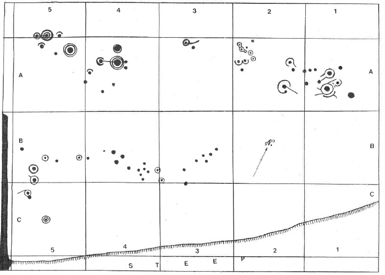
Source: Bradley et at 2019

The glacial striations and signs of plucking found during the excavation may also have played a role in the significance of these outcrops, not least due to the entanglement of symbols with cracks, veins and so on evident on the surface of Auchnacraig 1. Unlike other rock art sites such as Torbhlaren, Argyll and Bute (Jones et al. 2011), no material was found in any cracks on either outcrop although several large stones are still to be analysed.

The collection of rocks found in Trench A1a was at first glance interpreted as the result of a modern gardening activity. However, it is worth bearing in mind that a similar rocky setting at Copt Howe has been interpreted as a ‘rubble platform’ contemporary with the carving of the stone. This was, as at Auchnacraig, set up hard against a vertical face with carvings on it. Bradley et al (2019) have suggested this architectural trait is shared with Irish passage graves. That the rubble layer at Auchnacraig appears to have sat upon a layer we interpreted as a garden soil suggests this is not a likely interpretation of what we found, but it is worth bearing in mind and we cannot rule out the possibility that these stones were indeed set there in prehistory and our interpretation of the sequence might be revisited. A less well-defined version of this was found at Rock 1, Ben Lawers, Perth and Kinross, during excavations and interpreted as a ‘cobbled surface’ (Bradley et al 2012, 38).

Copt Howe platform
Possible prehistoric platform at Copt Howe (Bradley et al 2019)

Twentieth century use of the rock art as elaborate garden features is apparent, especially in the constructed wall or kerb on the south side of Auchnacraig 1. This kerb or wall continues for some 2m to the west, before merging or joining a broader coarser wall or bank which runs to the south. Morris’s photos of this stone (such as the one included above from 1968) show a similar drystone wall beyond the rock, suggesting these were two sides of a pathway skirting south of the rock art. This arrangement, and a possible rockery on the west side of the rock outcrop, will be explored in a future season of work.

The inclusion, probably deliberately, of a cup marked stone at the entrance area of the kerb or wall suggests the house owners were keen to celebrate the rock art in their garden and none of this is a coincidence. The discovery of a marble in this area suggests that the rock art outcrop here was not just a garden feature, but a place where children played; the latter was also the case at the Cochno Stone (Brophy 2018). It seems that this richly decorated stone was a matter of some pride for the house owners, and aspects of the garden here were arranged around it.

Acknowledgements

The excavation was funded by the Society of Antiquaries of Scotland.

Permission to carry out the work was given by West Dunbartonshire Council; thanks to Donald Petrie for arranging this.

Equipment was provided by the University of Glasgow. Thanks to Aris Palyvos for organising and transporting tools. We’re also grateful to the staff at Cochno Farm for allowing us to store equipment there.

Thanks to Tessa Poller, and Aris, for coming out to do the geophysical survey and survey the trench locations.

The site supervisor was Alison Douglas, and Alison also did all filming for Digging for Britain.

We appreciated the large number of helpers who came along and worked on site, in particular Tom Davis who put in a legendary performance. Other team members (in alphabetical order) were: Clare Archibald, Tristan Boyle, Pamela Diffin, Hayley Drysdale, Todd Ferguson, Lesley Fraser, Remy Grossman, Carolyn Hutchison, Christopher Ladds, Ellen Laird, Clare Love, Jools Maxwell, Rory McPherson, Gordon Morrison, Hannah Mould-Healy, Irene Pandolfi, Katherine Price, Linsey Reid, Nikki Reid, Hannah Ridley, Sandra Roxburgh, Jean and Tom Tumilty, Charlotte Walker, Jennifer Wallace, Simone Wason, Lauren Welsh, Ross Wood and Danielle Young.

Small finds were cleaned and catalogued by Dominic Pollock and Dominic also inked up and helped tidy the site drawings, some of which appear in this blog post.

We really appreciate the work done at these sites in March 2019 by the SCRAP team, led by Tertia Barnett and Maya Hoole. The 3D models of both rock art panels has been invaluable to this project.

Much appreciation to those who brought cakes: Jeremy Huggett, Dene Wright, Rebecca Younger and other friends who popped in with eagle eyes such as Gavin MacGregor.

Finally, thanks to each of the 100+ local people who visited the excavations including school children, and a massive thanks to the Clydebank High School Archaeology Club who came along and helped with the backfilling!

Clydebank Post 211114010
Clydebank Post, 4th July 2019. Thanks to Gil Paterson and team.

References

Bradley, R, Watson, A & Anderson-Whymark, H 2012 Excavation at four prehistoric rock-carvings on the Ben Lawers Estate, 2007-2010, Proceedings of the Society of Antiquaries of Scotland 142, 27-61.

Bradley, R, Watson, A & Style, P 2019 After the axes? The rock art at Copt Howe, North-west England, and the Neolithic sequence at Great Langdale. Proceedings of the Prehistoric Society to be published December 2019.

Brophy, K 2015 The Cochno Stone: an archaeological investigation. Phase 1 summary report. [Available from https://theurbanprehistorian.wordpress.com/2015/09/27/the-cochno-stone-exposed/]

Brophy, K 2016 Revealing the Cochno Stone: Phase 2 excavation and digital recording summary report. [Available from https://theurbanprehistorian.wordpress.com/2016/11/08/dig-cochno/]

Brophy, K 2018 ‘The finest set of cup and ring marks in existence’: the story of the Cochno Stone, West Dunbartonshire. Scottish Archaeological Journal 40, 1-23.

Harvey, J 1889 Notes on some undescribed cup-marked rocks at Duntocher, Dumbartonshire, Proceedings of the Society of Antiquaries of Scotland 23, 130-7.

Jones, A, Freedman, D, O’Connor, B & Lamdin-Whymark, H 2011 An animate landscape: rock-art and the prehistory of Kilmartin, Argyll, Scotland. Oxford: Windgather.

Morris, R W B 1981 The prehistoric rock-art of southern Scotland (except Argyll and Galloway), Oxford: BAR British Series 86.

The art of the Cochno Stone part 2

In my first post looking at art and the Cochno Stone, I considered the 5,000 year-old tradition of using this domed sandstone surface as a canvas for various creative acts in the form of shallow scratches, deeply incised hollows and painted lines. These surface alterations are ambiguous in meaning, each with their own aesthetic qualities and values, either reducing or adding to the monument, all of them inspiring passionate opinions.

cups and rings and lines and scales

In this second post, I would like to consider the art of the Cochno Stone from another perspective, through the medium of sketches and drawings, specifically those drawn from life (ie before the stone was buried in 1965) over a period between the 1880s and 1930s. No doubt there will be some who will argue that some of these drawings are not really works of art and creativity. For instance, can we regard ‘measured’ depictions of something, technical drawings as part of an archaeological study, as being creative or simply reductive? And what is the archaeological value of studying archive material or newspaper clippings with old drawings when we know with the benefit of hindsight that the drawings are either inaccurate, or incomplete, or both? More fundamentally – and this gets to the roots of much debate on the nature of archaeological narratives – to what extent are these objective renderings of the Cochno Stone? Is such a thing even possible? There are layers of art entangled with art here, the art of art, about art, for art.

Regardless of the motivation, medium, and intended audience, I would argue that there is a deeply artistic strand running through the history of attempts to capture the spirit of Cochno and I hope that this story of four decades worth of drawing and sketching the Cochno Stone will persuade you of this. Before getting to the real stuff, however, I want to reflect a little more on the art of depicting rock-art, and this also has resonance for part 3 of this sequence of posts, which will focus on art inspired by the Cochno Stone, so please take notes! 😉


The art of rock-art

Prehistoric rock-art lends itself well to contemporary variations in unusual locations, with the simple form and shallow depth endlessly replicatable. Wherever it occurs, if offers a juxtaposition, a curious time slip. Palaeolithic rock-art – cave paintings to you and me – work especially well in this respect, with otherwordly effects as standard.

cumbernauld
Cumbernauld shopping mall mural (artist unknown)

twitter source unknown
I confess I got this from twitter but have no idea who tweeted it, sorry!

More abstract Neolithic and Bronze Age rock-art works is equally portable. This lovely image is in Umea, Sweden, photographed by Lorna Richardson (and reproduced here with permission). This was part of a campaign by the local authorities to promote cycling and draws on the local rock-art repertoire which is a little less abstract than the Scottish equivalents.

Umea urban rock-art Lorna Richardson pic
Photo: Lorna Richardson

Many artists have been inspired by the simplicity and concentricity of cup-and-ring marks. Gavin MacGregor wrote about one such artist, Edward Atkinson Hornel (1864-1933), a landscape painter who lived most of his life in and around Kirkcudbright in southwest Scotland, and one of the famous ‘Glasgow boys’. Gavin notes that Hornel consorted with antiquarians and was himself a keen amateur archaeologist, and as it happens, Kirkcudbright happens to be a real hotspot for rock-art (as well as being the location of some shooting for The Wicker Man movie).

(c) Glasgow Museums; Supplied by The Public Catalogue Foundation
The Brownie of Blednoch (1889)

MacGregor, and the biographer of Hornel, Bill Smith, both draw attention to the echoes of cup-and-ring marks in the depiction of the moon in painting such as The Brownie of Blednoch (1889) and The Druids: bringing in the mistletoe (1890, with George Henry). Gavin notes the former (see above) is dominated by a ‘Gallovoidian shepherd beast, beard of circles and cup-marked eyes … manifestation of the living rock….’. Hornel went as far as to search for new cup-and-ring marked stones and some of his discoveries were recorded in the Proceedings of the Society of Antiquaries of Scotland.

It is in the work of the polymath-antiquarian-artist-archaeologist that we find the first recorded artwork associated with the Cochno Stone, with the earliest engagements mediated by various characters of this ilk as well as clergymen. The earliest drawings we have of rock-art in the pages of antiquarians books of the nineteenth century emerged form such a melting pot of influences and interests, blurring the lines between art and objective record, in fascinating ways. Hornel was himself involved in the process of the creation of a series of black and white engravings of Kirkcudbrightshire rock-art, which MacGregor notes were collaborations between a small team and were based on photographs taken of casts made from rock-art panels.

High Banks engraving

This is a period when the first drawings as a matter of record were being produced for cup-and-ring marks, and there was no rulebook, no style guide, no best practice conventions to follow. Artists used licence and produced evocative and memorable images, which often used unusual perspectives and were, for a time, concerned with context and not metrical accuracy.

Stronach Ridge drawing
Somerville’s 1901 sketch of the Stronach Ridge cup-and-ring marks, Arran

It was also around this time that a young Ludovic Mann became obsessed with cup-and-rings marks near the rural family holiday home, according to Katinka Dalglish, an obsession that would reach its feverish conclusion on the surface of the Cochno Stone to which we now turn. Before going any further in this post, I must also offer the debt of gratitude I owe to Jim Mearns for doing much of the archive research which underpins the history of early drawings of Cochno.


Sketches and symbols

Several drawings or sketches of the Cochno Stone were undertaken before 1900, each with a very different style, scope and ambition. (A cast was also taken although the nature and fate of this remains unknown.) These wonderfully capture the emergent understanding of Cochno, presenting only symbols that were initially visible, sometimes selectively so. The gradual reveal of the removal of grass from the stone was played out in these artistic renderings and associated accounts.

A partial drawing, defined within a box, was published with the first detailed account of the Cochno Stone, by Rev James Harvey, in 1889. This may well be the earliest drawing we have of any part of the Cochno stone, certainly the first to be published, and it focuses on the only area of the stone cleared when Harvey encountered it. This is a rather plain drawing, with cupmarks represented as dots and dashes, and lacking depth. Harvey himself did the drawings in 1887, but also took rubbings, which he was then able to use to correct his field sketches. The end product has a sense of immediacy, a work in progress, megalithic notations in a sketchbook. Looking at this sketch now for me is slightly disorientating as east is to the top, but is a welcome break from the tyranny of the north. However, this is also a drawing of some authority, having been published in that august organ the Proceedings of the Society of Antiquaries of Scotland (PSAS).

Harvey published drawing

The wonderful little sketch below was drawn by another minister, the Rev Robert Munro at the latest in 1890. It shows edited highlights of what must have been visible at that time. Two slightly different versions of this drawing were reproduced, the earliest, remarkably, in The Illustrated London News on 6th September 1890. A slightly amended version was then included in John Bruce’s History of Old Kilpatrick (1893). (A further version of this was reproduced in Harry Bell’s 1980s book Glasgow’s Secret Geometry but wrongly attributed to William Donnelly.)

ILN version of the drawing 1890
1890 (top), 1893 (below)

Harvey drawing detail

When compared with what we know of Cochno now from our excavation of 2016, some of this drawing is quite fanciful, but it is also an image that has real depth. (The version published by Bruce even has the feel of a rubbing, a nice observation made by Grahame Gardner.) However, unlike Harvey’s drawing, there is no scale here, thus giving the drawing a sense of being more of an artistic and interpretive depiction rather than a document of precise record. This is perhaps the case, as elements of this depiction of the stone are spatially impossible, with symbols simply in the wrong place relative to one another and so this is an image of cup-and-ring mark density, not accuracy. The use of a sharply defined diagonal line allows symbols from another part of the stone – in this case the south-western extent, several metres from the other symbols to be shown in the same drawing, making this a sort of ‘Cochno Stone greatest hits’ compilation.

This emphasis on selected bits of the Cochno Stone was countered by the clearing of vegetation, and drawing of the whole monument, by William Donnelly in the mid-1890s, working with John Bruce. Illustrator Donnelly’s drawing of the whole of the stone was published in PSAS in 1896, but a slightly earlier and different version was printed in an edition of Bruce’s History of Old Kilpatrick and includes the artist’s signature and the date – 1895. The slightly earlier drawing, the upper of the two versions depicted below, is notable for its inclusion of a north arrow and some landscape detail that are inexplicably absent from the more widely circulated ‘authoritative’ PSAS version.

Bruce material on Cochno 005

Figure 3
Donnelly’s drawing from 1895 (top) and 1896. Spot the differences!

Donnelly himself was an interesting character, and his illustrations showed an equally bold approach to cup-and-ring mark symbols found elsewhere.

william donnelly
William Donnelly at work with a sweaty forehead (c) HES

dumbuck-dubious-debris
Hoax carved stone objects found near Dumbuck Crannog (c) HES

His depiction of symbols of these hoax items found during his excavations (with John Bruce, him again) have echoes of what he saw and drew at Cochno just a few years previously, and suggest a hankering towards the weird and esoteric which he was also able to satisfy at Cochno with his recording of a cross in a circle and two four-toe footprints, neither typical prehistoric motifs. On the cusp of archaeological professionalism, but with visibility and access to archaeological sites still somewhat limited, at the turn of the century such drawings had to be taken on trust.

Yet the rise in interest and participation in rambling and hikes in the early decades of the twentieth century allowed less authoritative accounts of archaeological monuments to be composed and disseminated. The only two sketches of the Cochno Stone that I know of from between 1900 and 1965 were both drawn by non-professional archaeologists.

The earliest of these was published, firstly in the Glasgow Evening Times newspaper in 1909, and then in the book Some Sylvan Scenes near Glasgow by T C F Brotchie in 1910.

Brotchie drawing

Brotchie book

This lovely sketch captures a very small fragment of the Cochno Stone focused on a ‘dumb-bell’ motif, sketched at the end of a good ‘Saturday afternoon ramble’. This is a truly artistic rendering, taken from an oblique angle rather than depicting the plan view, with no scale, no north arrow, no conventions – but a sufficiency of dynamism. The rings around the cup have a real sense of mobility, almost as if the symbols were spinning in front of Brotchie’s eyes. There is also a synechdotal quality to this sketch, a gutter running off the right-hand side of the drawing hinting at more to be discovered (and drawn) beyond the frame.

Such dynamism is also evident in another Cochno Stone drawing, one which I have reproduced before, notably in the excavation summary report. Ludovic Mann’s audacious attempt to explain the cosmological meaning of each ring of a cup-and-ring mark complex is as mind-blowing now as it must have been when published in the late 1930s as part of a consideration of the Knappers site he had been excavating in nearby Clydebank.

Figure 5
Source: Mann’s 1939 booklet The Druid Temple Explained.

This ‘dialectogram’ (for the wonderful work of Mitch Miller is one of the best parallels I can think of here) is an amalgam of all the other Cochno drawings to that date. There is convention. There is artistic licence. There is narrative. There is a focus on the giant cup-and-ring mark motifs on the upper reaches of the Cochno Stone that also featured prominently in the drawings of Munro, Harvey and Donnelly. There is passion. And there is wonder.

And there are more questions than answers. Always more questions than answers.

All of these Cochno Stones drawings, produced over a period of forty years, offer a series of dynamic and creative attempts to document and make sense of the cup-and-ring marks, using the conventions and styles of their time and channeled through the personal motivations and passions of the artist-recorder. In their own ways, each of these drawing is a version of the Cochno Stone that captures some of the character of the rock and its symbols and taken together they form a compelling biography of this place, another chapter of a story that began to be written (before there was writing) 5,000 years ago.

What I especially find alluring about this collection of drawings is that they were drawn from life – by actually standing at the site and looking at the stone. This is where Morris’s much reproduced drawing of the stone falls short – it was cobbled together from the plans by Harvey and Donnelly, and some photographs from the 1930s. While it was (until our photogrammetric and laser survey of 2016) the most comprehensive drawing of the Cochno Stone produced, it creaks at the edges with the slightest bit of scrutiny especially when compared with earlier, more dynamic, drawings. It is clinical, transactional, flat.

decent drawing of the stone
Source: Morris 1981

Morris, a solicitor, was a lateral thinker. To really start to make sense of rock-art, concentric thinking is required.


Thinking concentrically

One of the most common questions that I get asked about the Cochno Stone regards the meaning of the symbols, and regardless of how accurately we record and draw the cupmarks and the cups-and-rings and the gutters, that meaning cannot be revealed to us. Therefore, despite the formal and technical shortcomings of some of the earlier drawings of the Cochno Stone, these are no more or less likely to help make sense of the symbols than any image we could generate now that was mediated through digital technology. In this case at least, the pencil is no more or less mighty than the pixel.

Figure 13 Laser scan

The joy of the art of the Cochno Stone – and indeed any abstract rock-art – is not about accuracy, or precision, but about mediation, dialogue, spending time with the stone, tracing the contours of the prehistoric depressions with our fingers. There is much merit in standing back and letting a laser scanner do its thing, or viewing the stone through the lens of the camera. But drawings and sketches involve a powerful intimacy that mirrors the acts that created the rock-art in the first place.

Forget the scales. We don’t need north arrows. Making sense of rock-art is about thinking concentrically, not metrically.

S Jeffrey Sian Jones cleaning rock-art
Auchnacraig rock-art panel, near Cochno (Photo: Stuart Jeffrey)

In the final part of my series of posts looking at the art of the Cochno Stone, I will consider art and creative acts that have been inspired by the Cochno Stone, but that exist spatially somewhere else. In some cases they have only had a brief existence or do not exist at all. A mural, a comic book, Chalkno stones and inspired architectural design all attest to the power of Cochno to provoke a response and empower.


Sources and acknowledgements: as noted in the post, the story of the antiquarian and early drawings of the Cochno Stone could not have been told without the research and diligence of Jim Mearns. Thanks also to Katinka Dalglish, Gavin MacGregor and Alex Hale for the input that their research has had on this post and I have linked to their work where possible. For more on Donnelly and Dumbuck, you can download for free Alex and Rob Sands’ book Controversy on the Clyde: archaeologists, fakes and forgers from here. The biography of Hornel alluded to is Bill Smith’s 2010 book Hornel: the life and work of Edward Atkinson Hornel. I’m also very grateful to Lorna Richardson for both allowing me to use her Umea photograph, but giving me some background context for the image. 

The High Banks rock-art drawing came from Hamilton’s paper in PSAS 23 (1888-9) ‘Notice of additional groups of carvings of cups and circles on rock surfaces at High Banks, Kircudbrightshire’. The Stronach rock-art sketch comes from Somerville’s PSAS article, ‘Notice of cup- and ring-marked rocks on the Stronach Ridge, near Brodick, Arran’ (volume 35, 1900-1901). All PSAS articles can be downloaded free.

Ronald Morris’s drawing of the Cochno Stone comes from his 1981 BAR volume The prehistoric rock art of southern Scotland (except Argyll and Galloway).

Other image permissions have been included in the captions, or the text accompanying the images

Walking Ludovic Mann

This is a slightly updated version of the text of a paper I gave at a conference held in the Pearce Institute, Govan, on Saturday 17th October 2015. The event was ‘EcoCultures: Glasgow’s Festival of Environmental Research, Policy and Practice’ and it was organised by Glasgow University PhD students Kirsty Strang and Alexandra Campbell. For more information on this excellent event, see the festival Facebook site and twitter feed (@EcoCultures, #EcoCultures). I believe podcasts of lectures and round tables will be made available soon; I will update the blog to include a link when this happens. I would like to thank the organisers for inviting me to contribute.

My paper. Literally.


Walking Ludovic Mann 

Ludovic McLellan Mann wrote the secret history of Glasgow.

He sketched out the shape of an invisible city.

He sensed the possibility of another Glasgow, beneath Glasgow.

Beneath their feet. Beneath their trams. Beneath their omnibuses.

The prehistory of Glasgow.


Ludovic McLellan Mann was present at the birth of this modern city.

A growing, expanding city.

A process that required the eradication of what came before.

The quarrying away of the past.

The burying of the ancient.

Building on the dead.

The price that had to be paid.


Ludovic McLellan Mann was busy. He was aware of opportunities. He took advantage of serendipitous discoveries. His ear was to the ground. He sniffed out the past. He called in favours. He took advantage. He seized control. He drove the agenda. He brought in his friends, the suits and the specialists. And he welcomed the glare of publicity that went with all of it.


Bronze Age pots and chunks of cremated human bone were extracted from graves.

Prehistoric stone coffins were dismantled in newly created back gardens.

Neolithic pits, hollows, quernstones and hearths were rescued from the quarry face.

Ancient carvings on rocks in parks and golf courses were drawn and quartered.

 He was everywhere. He was busy. He was aware of opportunities. He took advantage of serendipitous discoveries. His ear was to the ground. He sniffed out the past.


Ludovic McLellan Mann.

Glasgow’s gentleman archaeologist.

Accountant.

Insurance broker.

Showman.

Opportunist.

Digger.


Flamboyant antiquarian.

Amateur archaeologist.


Ludovic McLellan Mann wrote the secret history of Glasgow.

He sketched out the shape of an invisible city.

He was everywhere. He was busy. He was aware of opportunities.

He sensed the possibility of another Glasgow, beneath Glasgow.

Beneath their feet. Beneath their trams. Beneath their omnibuses.

His ear was to the ground. He sniffed out the past.

The prehistory of Glasgow.


Ludovic McLellan Mann (1869–1955) was a polarising figure in the world of Scottish archaeology. He was less controversial in his main trade: an insurance broker. In 1900 he patented his own system of consequential fire loss indemnity, which was widely adopted in that industry. However, in 1901 he became a Fellow of the Society of Antiquaries of Scotland, hinting at a parallel career – as an aspiring archaeologist, although was he never truly accepted by the establishment even although he spent a good deal of time cultivating his reputation as an ‘eminent archaeologist’. In the end, leading academics took to print to condemn and mock him.

Mann in 1905 (c) Glasgow Museums and Art Galleries)
Mann in 1905 ((c) Glasgow Museums and Art Galleries)

However, Mann did have a high profile within the Glasgow Archaeological Society, and for the early part of his career had broad-ranging interests, and was published widely. In 1911 he curated the Prehistoric Gallery of the Scottish Exhibition in Kelvingrove Park. This was the result of two years of work by Mann, and the exhibition space he designed was crammed full of hundreds of pots, stone tools and metal weapons, reconstructions, scale models and the walls were adorned with 16 large wall charts. Prehistoric tableaux were created using the soil of Glasgow, extracted from excavation sites. The central feature of the gallery was the ‘life-sized statue of a typical man of the late Stone Age’ sculpted by Alexander Proudfoot.

prehistory gallery

A series of decent quality excavations, eclectic collecting activities and innovative research projects maintained his profile, but by the mid-1920s his reputation and activities began to change. Archaeologist Graham Ritchie noted that by 1923: ‘Mann seems to have lost the ability to prepare coherent excavation reports, perhaps because some of his discoveries were piecemeal and because site survey was not his strong point’. Mann also had a tendency towards losing interest in projects before bringing them to a conclusion, and in time, veered towards the fantastical and eccentric in his interpretations of his prehistoric discoveries, alienating himself theoretically as well as methodologically from his peers.

Workmen helping excavate a cist cemetery in advance of construction of a school in Cambuslang (c) RCAHMS image number SC01338023

He started to bypass mainstream academic publishing. His methods were simple. He watched out for opportunities to help with and drive forward excavations based on chance discoveries, information for which was sometimes retrieved from the news clipping services he subscribed too. Neolithic settlement traces found in a quarry. Cremation urns discovered in advance of construction of new houses. Discoveries reported to him by the public, his network of sources. He would move in, and either take over entirely from whoever had been doing the archaeology, or he took on the role of eminent archaeological overseer and site director recovering and excavating things as they were found. And all the while, he was talking to local journalists and national newspapers, disseminating his results, reporting on his work, bypassing the conventional and traditional academic publications that rarely if ever published his work in the second half of his career. His outlet was the print media: national press, local papers. The Glasgow Herald. The Scotsman. The Express. The Hamilton Advertiser. He even set up his own eponymous publishing imprint and spoke widely to local historical societies and public audiences.

Mann was born and lived most of life in Glasgow. And he did much work, both in terms of excavation and recording, in Glasgow and the surrounds of the city. He was obsessed with the past of Glasgow – the ancient, occult framework of the city, the obscure origins of roads and churches and cemeteries, folk takes and myths of gods and temples. His own excavations underpinned his beliefs in an intelligent pagan ancestry for Glasgow – fine quality pots, wonderful stone tools and well-made graves attested to this.

Pots from the Newlands excavations, found in 1905 (c) RCAHMS image number SC01331866


Ludovic McLellan Mann wrote the secret history of Glasgow.

He sketched out the shape of an invisible city.

He sensed the possibility of another Glasgow, beneath Glasgow.


He took the city apart and put it together again.

He extracted the long dead.

He painted the past.

He exploited the past for its own good.

He celebrated prehistoric Mann.


A Bronze Age cemetery in Newlands, near where he was brought up, in 1905

A cist cemetery at Greenoakhill, Mt Vernon, near where he lived, in 1928

Two cists and a cremation deposit found during the construction of Dalton School, Cambuslang in 1930

Knappers cemetery and Neolithic timber structure in 1933 and 1937

The Cochno Stone in 1937


After his excavations, like a serial killer, he kept souvenirs – tokens – trophies – to remind him of his work. The Bronze Age cinerary urns from his first prehistoric dig in Glasgow, at Langside, remained in his possession until his death 50 years later.

Mann wrote a book on prehistoric Glasgow – a pamphlet he published in 1938 called Ancient Glasgow: A temple of the moon. Here, Mann laid out the occult history of Glasgow.


The mounds of Glasgow

Moon sanctuaries at the Necropolis

The ancient Grummel mound where High Street and Rottenrow and meet

The sanctuary of St Enoch

The sanctity of the Molendinar Burn


Ancient gods, ancient places, ancient traditions, ancient mounds, ancient temples. All beneath the modern grid plan of the city. Hidden – but still there is you knew where to look, where to walk. The ancient sacred geometry of Glasgow still informing the grid. Powering the grid. Shaping the grid.


Occult alignments.

Sacred roadways.

Unearthly mounds.

Secret temples.

Buried cemeteries.


All part of a network, connections spanning time and place, subverting the straight jacket of urbanisation, defying the order of the modern city.

Mann wrote the book. He created the past, with his trowel, his pen, his chalk and his paints. He reconceptualised Glasgow as a pagan city. He held in his hands the ashes and burnt bones of the noble savages that once lived in this place. He looked upon their fine pots, and their sharp, elegant axes. His work was at the cutting edge and on the fringe: the fringe of the discipline, the fringe of the city, the edge of modernity, the cusp of science, the past in the present.

He was the first urban prehistorian.

 front_cover Earliest Glasgow

Over the past couple of years I have been visiting the locations of various sites that were excavated or studied by Ludovic Mann both within and around Glasgow.

Mann’s research into prehistoric Glasgow can helped us piece together another Glasgow, an ancient one, in the heart of the city but also in its suburbs and arterial routes. By walking these routes, and visiting these sites, I am trying to foreground once again the prehistoric within these urban contexts, piecing together a narrative that is all but lost and forgotten.

Following maps within maps, a city within a city, secret maps, secret cities.

One of the oldest roads in Glasgow is Rottenrow, which runs towards the cathedral from the city centre. But before the cathedral, according to Mann, there stood an ancient earthen mound called Grummel Knowe, at the junction of High Street and Rottenrow.

Extract from Mann's Earliest Glasgow
Extract from Mann’s Earliest Glasgow


An ancient geometry, just beneath the skin of the city.

Walking between locations that no longer exist.

Following routes that have been forgotten.

Visiting sites that have been altered out of all recognition.

Remembering the lost and celebrating the dead.

Walking Ludovic Mann’s Glasgow is to walk prehistoric Glasgow.


Glasgow’s ancient past intrudes into the present in surprising and peculiar ways. One of the most famous sites excavated by Ludovic Mann was a Neolithic complex of timber structures and pits, and Bronze Age graves, at Knappers, on Great Western Road in Clydebank. This site was taken on by Mann after initial excavations had revealed a series of prehistoric features during quarrying in 1933. In 1937 Mann excavated an extensive group of features which he interpreted as stake- and post-holes, the remnants of a spiral timber setting with accompanying earthworks. He reconstructed this monument and went on a publicity drive, proclaiming it a major discovery. Literally thousands of Glaswegians headed down to Duntocher Boulevard to witness this spectacle and see Mann in full flow, lecturing to the masses. Mann even published adverts about the dig and suggested routes and means of travel to this site.

explained_routes low res

Knappers today is a very different place.

DIGITAL CAMERA

knappers today low res

Sketch from Knappers walk

fungal ring low res

chalk rock art low res

pit location low res

This is a location where the prehistoric traces are still evident in the fabric of the grass and tarmac. The architecture of urban dwelling and the car in particular reflects the Neolithic circular structures that were found by Mann: circular bays of garages, roundabouts, towering uprights, landscaping stone blocks in playgrounds.

The relatively modern housing estate across the road was constructed in the location of another Early Bronze Age cemetery that was excavated by GUARD archaeology in advance of development in 1997 and 1998.

The living and the dead.

The living on the dead.

Also in Clydebank is another site which Mann is intrinsically connected to – the Cochno Stone (for background, see a previous post on this blog).

Ludovic Mann on the Cochno Stone in 1937 (c) RCAHMS image number SC01062363

Mann’s intervention here was not typical – it wasn’t an excavation. Rather, he took an interest in the esoteric patterns he saw on this rock – spirals, weird symbols, crosses, and stars. In order for visitors to better appreciate the stone in 1937 Mann painted the symbols with a white organic mixture (and perhaps other colours too). Overlain on the prehistoric markings was a measured and complex grid system of his own devising which helped him interpret the code. Mann was by now obsessed with the mathematical and astronomical properties of such symbols and it is almost certain many of the shapes he painted on the stone were fantasies of his own construction. He began to find what he wanted to find.

And this time his publicity-seeking activities backfired. In a letter which has just come into my possession, written by a solicitor on behalf of the man who owned the Cochno Stone in 1937, it was noted:

As a result of the activities of certain antiquarians who have expended much care on the decoration of the monument, a considerable amount of public interest has recently been directed to the stone, with the result that large numbers of people from the surrounding industrial district and elsewhere are in the habit of visiting the site, particularly at week-ends, where it is the destination of an almost constant stream of sightseers. As a result considerable damage is being done by the behaviour of persons who are attracted more by curiosity than antiquarian interest.

And when I opened a small trench over the stone in early September, evidence of this damage was very clear, with graffiti, perhaps carved just before the stone was finally buried in the Spring of 1965, and black paint splattered over the surface of the rock-art.

Vandalism to the Cochno Stone (photo taken during my excavation there in September 2015)

Here, Mann had enthused the public about a prehistoric monument to the extent that the establishment had to intervene. He was too successful. He had not predicted the hunger for this kind of thing. But the wider message seemed to be that a little knowledge was a dangerous thing where the wider public was concerned. And so attacks of Mann’s abilities and theories began in archaeological circles and the press.

His prehistoric Glasgow began to fall apart. Plans were set in place to protect the Cochno Stone – from Glaswegian visitors and from Mann himself. A decade after Mann’s death the wall around the Cochno Stone was kicked over. Earth was dumped on it.

Mann started this.

Landowners and the Ministry finished it.

Buried without a trace.


This paper comes at an early stage in my Walking Ludovic Mann project and in the coming months and years I intend to visit – and walk between – a wide range of locations of significance to Mann’s prehistoric Glasgow. Previous blog posts have reported on work Mann did outwith the city – Ferniegair cist cemetery for instance in South Lanarkshire, and Townhead Neolithic settlement on Bute. But I now want to retreat back to the city, to retrace the work of Mann with my feet, to see what remains of his secret grid and his sacred geometry beneath the fabric of this modern city.


The discoveries of Ludovic Mann in essence sketched out the structure of prehistoric Glasgow.

A Glasgow before it was Glasgow.

His eccentric research and eclectic interests allowed a different way of thinking about familiar Glasgow streets, landmarks and place names.

 A map within a map. A city within a city. A secret map. A secret city.


His probing mind.

His dirty hands.

His obsessive measuring.

Mann’s voracious collecting.

Mann’s prehistoric fetishizing.

Mann’s insistent storytelling.


Mann’s underground city, Glasgow inverted, Glasgow’s past dragged back into the present, raised from the dead. Passing through wormholes. Tears in space and time.

Prehistoric Glasgow revealed – for all to see – if they care to look.

Secret geography. Sacred geometry.

Deep time.

Timeless. Effortless.

Walk and talk and chalk Ludovic McLellan Mann’s Glasgow.


Sources and acknowledgements: much of the biographical information in this lecture came from Graham Ritchie’s excellent paper Ludovic McLellan Mann (1869–1955): ‘the eminent archaeologist’, published in the Proceedings of the Society of Antiquaries of Scotland volume 132, pages 43-64 (2002). If you google it, you can find this article freely available online. The front cover of the Mann pamphlet and the route to get to and from Knappers were sourced thanks to this really helpful webpage which has scanned and reproduced various ‘earth mysteries’ books and pamphlets. Various images, sourced from the former RCAHMS, have been reproduced under their creative commons policy with image codes in the captions.


Links:

EcoCultures: www.facebook.com/events/114920895512376/

Mann booklet source: http://www.cantab.net/users/michael.behrend/repubs/index.html