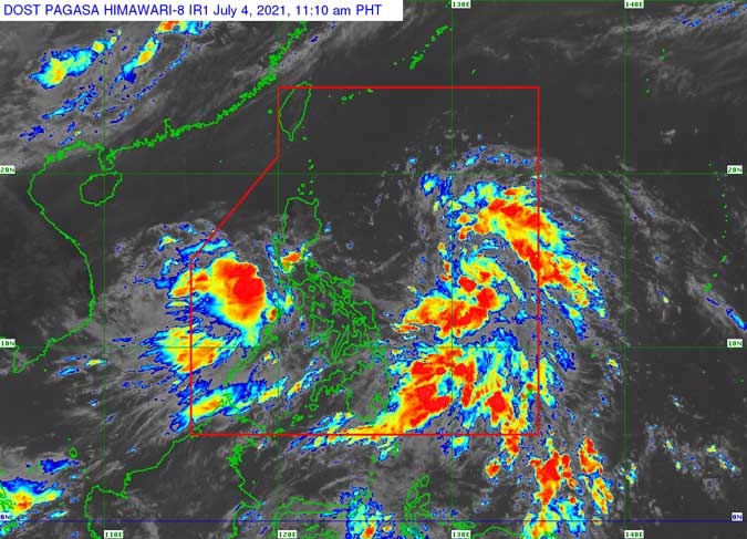
Typhoon, low pressure area to bring rains across PHL

TWO WEATHER disturbances — a tropical depression and a low pressure area (LPA) — will bring scattered rains and thunderstorms across most parts of the country until Tuesday, weather agency PAGASA reported Sunday.
Tropical depression Emong, which was a low pressure area until around 8:00 a.m. Sunday, strengthened as it moved northwest towards the extreme northern part of Luzon.
Typhoon wind signal no. 1 was raised over Batanes and the northeastern part of Cagayan, including Babuyan Islands.
As of 11 a.m. Sunday, Emong was located 700 kilometers (kms) northeast of Guiuan, Eastern Samar in central Philippines.
It was packing maximum sustained winds of 45 kms per hour near the center and gustiness of up to 55 kms per hour.
“Emong is likely to remain as a tropical depression throughout the forecast period,” the Philippine Atmospheric, Geophysical and Astronomical Services (PAGASA) said in its first advisory on the storm.
The other LPA, meanwhile, was located 120 kilometers east of Calapan, Oriental Mindoro as of 4 a.m. Monday and “is less likely to develop into a tropical depression within 24 hours,” according to PAGASA.
However, this LPA coupled with the southwest monsoon will bring light to moderate or at times heavy rains over Bulacan, Pampanga, Nueva Ecija, Zambales, Bataan, Metro Manila, Rizal, northern Quezon including Polillo Islands, Laguna, Cavite, Batangas, Palawan including Calamian Islands, Mindoro Provinces, and Antique.
PAGASA warned that “isolated flash floods and rain-induced landslides are possible during heavy or prolonged rainfall” in these areas.
If it strengthens into a tropical depression, it will be named Fabian.


