The Durance River is the principal river draining the French side of the Alps toward the Mediterranean. It originates from the south of the Alps and has a catchment area of about fourteen thousand square kilometers and a channel length of 325 kilometers. It is a braided gravel-bed river that runs throughout the north of the Provence and the last major Rhône River left bank tributary. This river has always been essential for local people who have maintained complex and beneficial relations with it. Both the need for water (to overcome recurring summer droughts) and to limit damage done by seasonal catastrophic floods sealed its fate very early. Its changing hydrology had for a long time drawn the attention of planners towards the need for a reservoir on the upper Durance. The idea of creating a dam on this river appeared in the mid-nineteenth century, after disastrous floods in 1843 and 1856 as well as major water shortages, as in 1895.

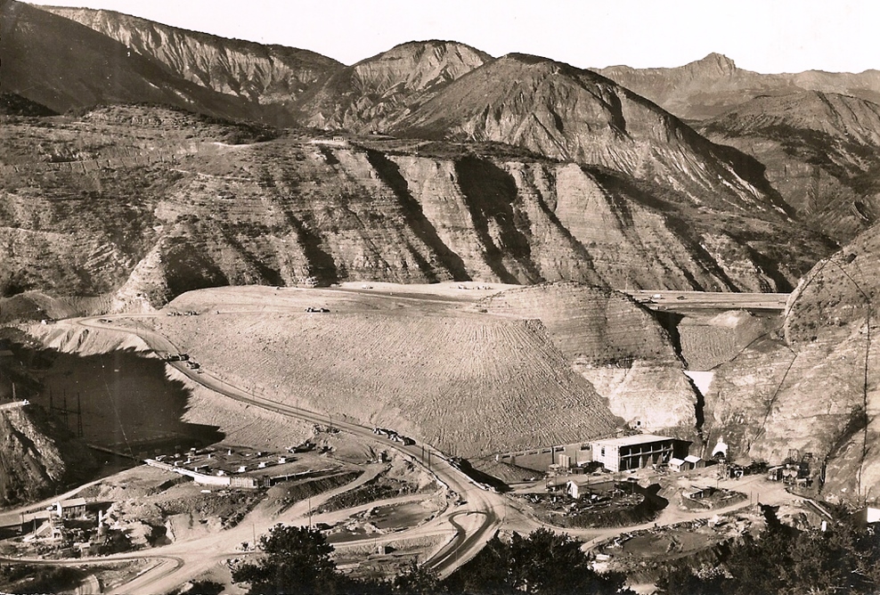
The Serre-Ponçon Valley and the Durance River before the construction of the dam (early twentieth century, south of the French Alps)
The Serre-Ponçon Valley and the Durance River before the construction of the dam (early twentieth century, south of the French Alps)
Historic photography (postcard) modified by Nicolas Maughan, 2014.
 This work is licensed under a Creative Commons Attribution-NonCommercial-ShareAlike 3.0 Unported License.
After all investigations, the site of Serre-Ponçon with narrow walls, located 75 kilometers downstream from the river’s spring, seemed ideal. From 1896 until the 1940s, civil engineer Ivan Wilhelm patiently planned the future dam design, but unfortunately failed to overcome issues related to set foundations on bedrock in the river channel. The construction became possible only after the Second World War thanks to technological advances in large dam construction.
The Serre-Ponçon dam was central to a wide, integrated river basin management plan to erect hydraulic infrastructures for carrying stored water to the lower watershed by harnessing the river’s strength. Because of the scale of this program, a law was created in 1955 named Loi d’aménagement de Serre-Ponçon et de la Basse Durance to define its three objectives: power provision, croplands irrigation and potable water supply in the Provence area, and the reduction of flood damage. Construction began in 1955, and its reservoir was completely filled with water by June 1961. After 1960, 19 other dams, hydraulic power plants, or canals were built on the river, while 14 others were built on its tributaries. Today, Serre-Ponçon is the second widest embankment dam in Europe (with a total capacity of 1.2 billion cubic meters) and the largest reservoir in metropolitan France in terms of volume.

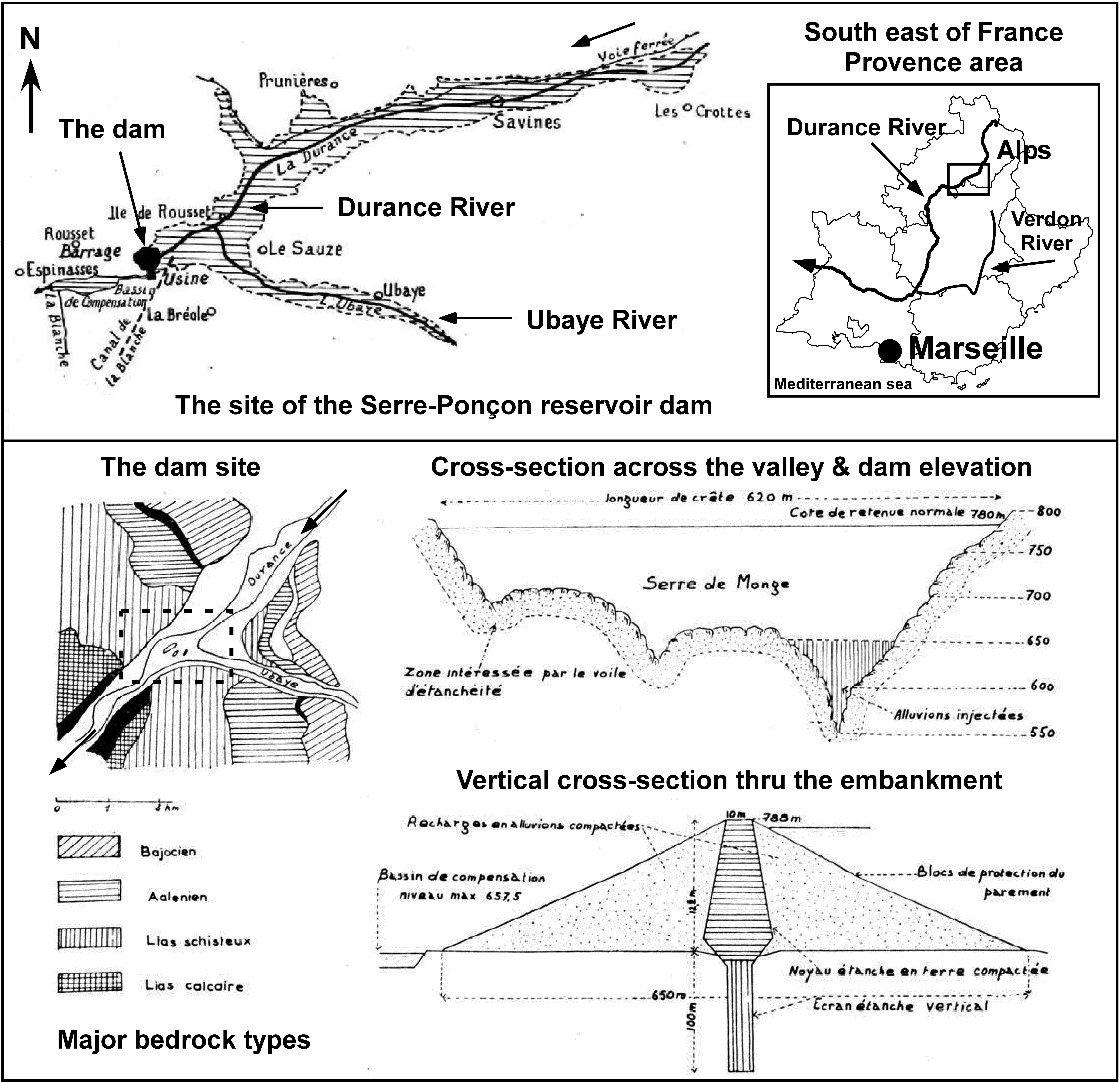
Location map of the Serre-Ponçon dam on the upper course of the Durance River (top map). Architectural plans of the reservoir: elevation of the dam and vertical cross-section through the embankment (below plan).
Location map of the Serre-Ponçon dam on the upper course of the Durance River (top map). Architectural plans of the reservoir: elevation of the dam and vertical cross-section through the embankment (below plan).
Map and plan source: PERSEE database, Revue de géographie alpine, 1953, 41 (2): 355–359 and 1960, 48 (4) : 625–687, modified by Nicolas Maughan, 2014.
This work is licensed under a Creative Commons Attribution-NonCommercial-ShareAlike 3.0 Unported License.
From the 1950s the extensive hydroelectric-power and irrigation-water supply projects in the Durance River (46 in all) allowed significant socio-economic and environmental transformations in southeastern France, turning the river into the most regulated waterway in France.
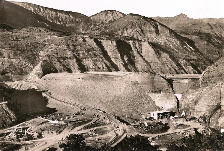
The embankment’s construction (rock fill with an impermeable clay core) in 1958 (looking upstream from the left bank). One can see the future power plant house at its base.
The embankment’s construction (rock fill with an impermeable clay core) in 1958 (looking upstream from the left bank). One can see the future power plant house at its base.
Historic photography (postcard) modified by Nicolas Maughan, 2014.
This work is licensed under a Creative Commons Attribution-NonCommercial-ShareAlike 3.0 Unported License.

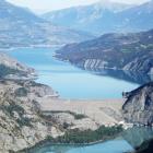
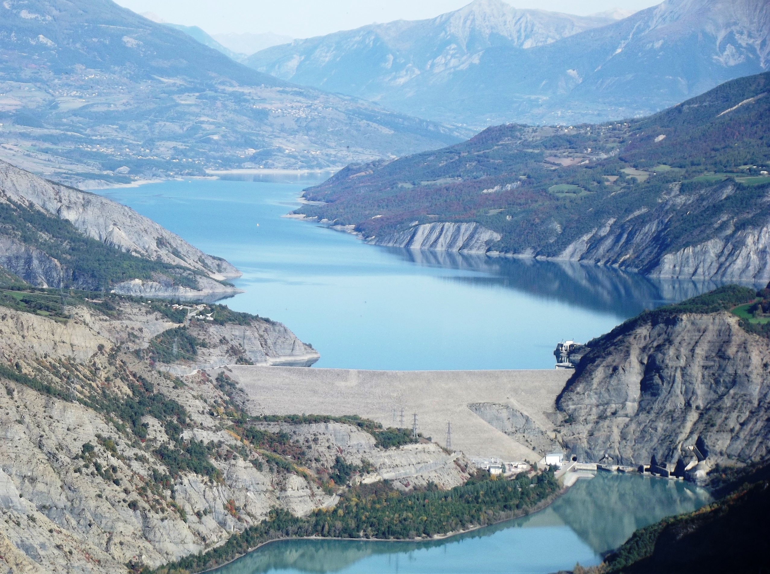
The Serre-Ponçon dam and the lake in 2013 (looking upstream from the left bank)
The Serre-Ponçon dam and the lake in 2013 (looking upstream from the left bank)
Historic photography (postcard) modified by Nicolas Maughan, 2014.
This work is licensed under a Creative Commons Attribution-NonCommercial-ShareAlike 3.0 Unported License.
But there were also environmental consequences. Apart from commonly observed modifications on the river’s hydrology and geomorphology, like the drastic decrease in flash floods and low water levels in the summer, other unexpected ecological phenomena quickly occurred. The width of the major river bed narrowed, the channel network contracted, and floodplain segments, characterized by a dynamic mosaic of aquatic/terrestrial habitats, began to vanish, allowing urban land expansion with an efficient agricultural exploitation of the nutrient-rich alluvial soils along the riverbanks. Then, a strong sediment flow reduction was quickly noted behind numerous reservoirs, which were problematic for water supply systems like the Canal de Marseille in past centuries. This flow reduction had a direct impact on both the Rhône River delta subsidence and the coastal erosion of the famous Camargue Biosphere Reserve.

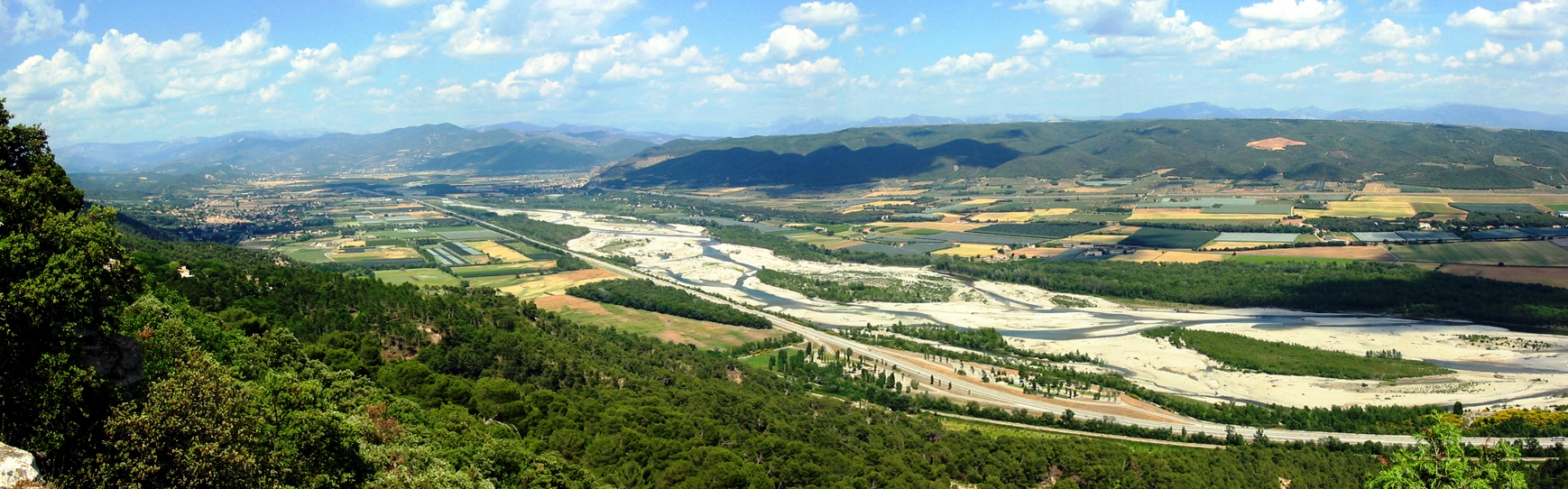
The Durance Valley in 2011 with some remaining floodplain segments during a summer low-flow period (looking upstream from the right bank)
The Durance Valley in 2011 with some remaining floodplain segments during a summer low-flow period (looking upstream from the right bank)
Historic photography (postcard) modified by Nicolas Maughan, 2014.
This work is licensed under a Creative Commons Attribution-NonCommercial-ShareAlike 3.0 Unported License.
Perhaps the most striking changes were the indirect ones to the Berre Pond (0.9 billion cubic meters). Indeed, this shallow coastal brackish pond suffered from a severe disturbance due to freshwater discharges, mixed with a large volume of suspended sediments (about 3.6 billion cubic meters or more 520,000 tons of silt per year), carried directly from the Serre-Ponçon Dam through a long concrete aqueduct to operate the Saint-Chamas hydropower plant. These water inputs, together with contaminants from surrounding local petrochemical activities (established since the 1930s), quickly caused a real environmental disaster due to the general silting of the lagoon, an acute decrease in salinity, and rapid changes in water physico-chemical parameters. A large portion of the rich aquatic life, commercial fisheries, and mussel farm sites subsequently disappeared. In a few decades, the pond became perhaps the most polluted in southern Europe with harmful socio-environmental aftermaths. It was not until around the 1990s with the rise of a new ecological consciousness, then under the European Water Framework Directive adopted in 2000, that concrete measures were implemented to limit exogenous freshwater discharges (a decrease of 35% by 1995) and eutrophication.
Finally, since the construction of the Serre-Ponçon Dam was the first step of both the Durance River regulation project and the ecological transformation of the stream, the wide hydraulic facilities, which later gradually branched out along the river valley, were the cause of the great environmental changes in regional hydrosystems, as well as deep mutations in urban and rural landscapes in southeastern France. And, the damming of the Verdon River, a major Durance left bank tributary, to strengthen urban water supply and irrigation thanks to a last aqueduct, the Canal de Provence, will finally tame one of the wildest fluvial network in Europe.

The Saint-Chamas hydropower plant on the North coast of the Berre Pond in 2003. It is the last hydraulic infrastructure of the Durance River regulation project.
The Saint-Chamas hydropower plant on the North coast of the Berre Pond in 2003. It is the last hydraulic infrastructure of the Durance River regulation project.
Historic photography (postcard) modified by Nicolas Maughan, 2014.
This work is licensed under a Creative Commons Attribution-NonCommercial-ShareAlike 3.0 Unported License.
How to cite
Maughan, Nicolas. “The Serre-Ponçon Dam and the Durance River: The Founding Act towards the most Regulated French Waterway.” Environment & Society Portal, Arcadia (2015), no. 16. Rachel Carson Center for Environment and Society. https://doi.org/10.5282/rcc/7309.
ISSN 2199-3408
Environment & Society Portal, Arcadia
 This work is licensed under a Creative Commons Attribution-NonCommercial-ShareAlike 4.0 International License.
2015 Nicolas Maughan
This refers only to the text and does not include any image rights.
Please click on an image to view its individual rights status.
- Bertin, Aimé. "Le barrage de Serre-Ponçon, pièce maîtresse de l'aménagement de la Durance." In Revue de géographie alpine 48, no. 4 (1960): 625–87.
- Veyret-Verner, Germaine. "Un grand barrage en terre: Serre-Ponçon et l'aménagement du bassin de la Durance dans les Hautes-Alpes." In Revue de géographie alpine 41, no. 2 (1953): 355–59.
- Warner, Robin F. "Environmental Impacts of Hydroelectric Power and other Anthropogenic Developments on the Hydromorphology and Ecology of the Durance Channel and the Etang de Berre, Southeast France." In Journal of Environmental Management 104 (2012): 35–50.
- Wilhelm, Ivan. "La Durance. Utilisation de ses eaux et amélioration de son régime par la création de barrages." In Bulletin De La Société D'études Des Hautes-Alpes 29 (1909): 37–107.
- Wilhelm, Ivan. La Durance. Étude de l'utilisation de ses eaux et de l'amélioration de son régime par la création de barrages. Paris, Lavaur, Marseille: Jouvène, 1913.


