
Summit Elevation (m): 2458
Trip Date: July 29 2016
Elevation Gain (m): 800
Round Trip Time (hr): 4.5
Total Trip Distance (km): 11
Quick ‘n Dirty Rating: Class 2/3 – you fall, you sprain something
Difficulty Notes: One short easy / moderate scrambling step and a steep, packed slope to the col with Whyte. Make sure the route is free of snow before attempting.
Technical Rating: SC5; YDS (Hiking)
GPS Track: Gaia
Map: Google Maps
If you’ve read my Cockscomb Mountain trip report, you should not be surprised that it’s been weeks since my last summit! I jest. Although my mountain mojo was a bit depleted in June / July, this isn’t the real reason I haven’t summitted a mountain in the last 7 weeks. There are two reasons for the break. The first was a three week holiday in July which saw me and my son do an epic 16 day canoe trip in Woodland Caribou Provincial Park in Ontario, Canada, followed by a week camping with family in Nutimik Lake, Manitoba.

The second reason was stairs and a laundry basket conspiring to break me. They didn’t succeed, but they seriously hurt my right foot – only two weeks before my canoe trip!! I am still seriously amazed that the trip turned out so well, considering how buggered my foot was when I started it. Obviously I had X-rays done right away and thankfully the heel / foot / leg wasn’t broken, but it was definitely damaged and for the first month I could barely walk on it. On returning home to YYC the foot was feeling quite a bit better and I decided on the August long weekend that it was time to test it out on some easy objectives. The first objective I chose was one that’s been on my radar for quite a few years already. Devil’s Thumb, in Lake Louise promised a short outing with great views in one of the most picturesque tourist havens in the world – a perfect place to test my bum foot.
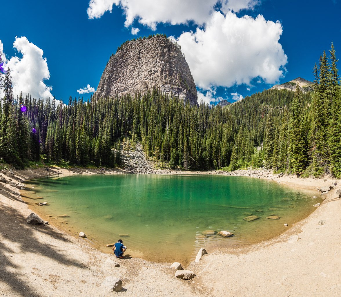
I left Calgary at what I thought was a reasonable time (07:00) on Friday morning, the day before the August long weekend. It turns out that Banff is having an extremely busy 2016, thanks to a low CAD and the Lake Louise parking lot was already getting full at 09:00! Oh well. I managed to park and started quickly up the path to Lake Agnes, passing hordes of tourists on the way. The morning was gorgeous and cool and within an hour I was at the lovely Lake Agnes, surveying the rest of my route up to the base of the Devil’s Thumb. My foot was behaving, even though I could definitely still feel the injury.


I rounded the lake on the Beehive trail, which I then followed up to the Beehive / Devil’s Thumb col. It’s a great idea to combine these two minor objectives if you can, since they’re so close. When I did the Beehive with Hanneke back in September 2010, we weren’t in the mood to add it to our day and I knew I’d be back some day, so we didn’t bother. A tree lay across the obvious trail leading to the Devil’s Thumb, probably to block folks who mistakenly think that’s the Beehive, but it didn’t slow me down as I deftly stepped over it and continued up the obvious worn path to the crux. The crux had three packs laying at its base when I was there – obviously some folks ahead of me didn’t feel comfortable taking their packs up it. I found the crux to be easy / moderate scrambling but fairly short. Right after the crux I met the three pack owners who had presumably made the summit – I’m not sure as we didn’t say more than “Hi” before continuing on our separate ways.


The traverse from the top of the crux to the steep gully leading to the Whyte / DT col was spectacular high line hiking! The views towards Haddo / Aberdeen, The Mitre, Lefroy and Victoria were mind blowing. IMHO, this section alone is worth the short crux, never mind the summit. After completing the sublime traverse


I came to the steep gully leading to the Whyte / DT col. The best footing up this steep, dirt gully can be found on climber’s left where there’s still some grass / shrubs holding the slope together. Mainly due to foot traffic, the center and climber’s right of the gully are a bit slick and I didn’t appreciate the footing in my flexible hiking boots on ascent.

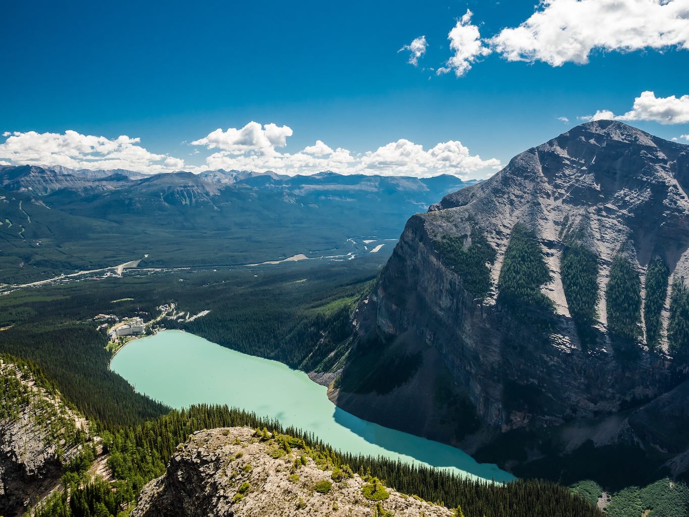

The views only improved as I crested the col and took in Whyte, Niblock and Piran from there. A quick jaunt up blocky terrain, going climber’s right at any obstacles, and I was on the summit of Devil’s Thumb with an incredible Lake Louise panorama stretched out before me. It was worth the easy scrambling to get to the eastern nose of the summit block for some great views of both Lake Agnes and Lake Louise, along with both the small and big Beehives.

Beware of kicking rocks down on folks ascending from Lake Agnes if you venture here yourself as the terrain is fairly loose on the nose of the summit block. I have so many good memories of many of the Lake Louise peaks. I spent almost 30 minutes at the summit, all by myself, before reluctantly starting back down. I wanted to beat the long weekend hordes and get home on time. So far my ankle was behaving better than expected.
The descent went well – although my heel obviously hurt more than on the way up. I did a slight variation just for fun, taking the switchbacks down to the Plain of Six Glaciers trail before short-cutting back to Mirror Lake and retracing my morning route to the parking lot – this time literally wadingthrough masses of people! Overall I was very impressed with the views on this short excursion. I can highly recommend it for people who don’t mind steep slopes and some minor exposure.