2021
SP8808 : Information Board at Boddington Hill Fort
taken 3 years ago, near to Halton Camp, Buckinghamshire, England
Information Board at Boddington Hill Fort
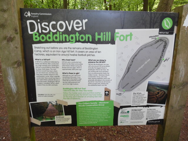
This photo shows the Forestry Commission information board at the north end of Boddington Hill Fort on Boddington Hill. It has the following wording:
Discover Boddington Hill Fort
Stretching out before you are the remains of Boddington
Camp, which is an Iron Age Fort. It covers an area of ten
hectares, equivalent to around twelve football pitches.
First column
What is a hill fort?
A hill fort is a settlement defended by
banks and ditches often constructed
on a high vantage point. Boddington
Hill Fort is surrounded on three sides
by steep chalk slopes. The main
entrance would have been where
you are stood now, and there may
have been another entrance in the
southwestern corner. When originally
constructed, there would have been a
four metre timber palisade (fence) on
top of the banks. Boddington Hill Fort
is called a 'univallate' hill fort, which
means it has one ditch and bank.
Univallate: From the Latin una
(one) and vallum (rampart)
Roundhouses (photo)
The community who lived in
the hill fort may have lived
in roundhouses like this.
Second column
Who lived here?
Hill forts were constructed and
lived in by the tribal communities
which lived in Britain during the
Bronze and Iron Ages, which is
approximately 3000 years ago.
What is there to see?
Although you can't see much
remaining at this point, if you
go around to the eastern edge
of the hill you'll find the banks
are very well preserved and
up to 3.6m high in places.
Boddington Hill Fort Trail
1.3km/0.8 miles (45 mins) East access
Follow the number posts and you'll find
another panel showing how the hill fort may have looked
on the way. You'll discover an amazing view over
the Vale of Aylesbury...
Third column
What are we doing to preserve the hill fort?
Hill forts like Boddington are rare,
with only around 150 across Britain.
Ironically, the biggest threat to
Boddington Hill Fort are trees. We
are working with local volunteers
from an environmental charity, the
Chiltern Society - Wendover Woods
Conservation Group, who have
been clearing vegetation which was
potentially damaging to the remains of
the hill fort. Over time we will remove
all the younger trees, leaving only
established beech and oak.
Right hand column
Plan of Boddington Hill Fort
Other hill forts (Photo of Maiden Castle)
Maiden Castle in Dorset
is the largest hill fort in
Britain. This aerial view clearly
shows the banks and
ditches. As you walk around
Boddington Hill Fort try to
imagine it without trees!
 Map © Crown Copyright")
TIP: Click the map for more Large scale mapping
- Grid Square
- SP8808, 95 images (more nearby 🔍)
- Photographer
- David Hillas (more nearby)
- Date Taken
- Monday, 31 May, 2021 (more nearby)
- Submitted
- Friday, 4 June, 2021
- Subject Location
-
OSGB36:
 SP 8838 0825 [10m precision]
WGS84: 51:45.9578N 0:43.2416W - Camera Location
-
OSGB36: SP 8839 0828
- View Direction
- South-southwest (about 202 degrees)