

Where is Nepal Located?
- by Gloria
- Last Updated: 2024-04-16
The Federal Democratic Republic of Nepal, commonly known as Nepal, is a landlocked country in the Himalayan region of South Asia. Nepal covers an area of 147,181sq.km (56,956 square miles)and it ranks 93rd in the world. The population of 29.72 million is ranked 48th in the world.
It is a country with multi-religious and multilingual. Nepal has a lot of ancient cultural heritage. You can find temples everywhere because the founder of Buddhism, Buddha Sakyamuni, was born in Nepal. The national main religion is Hinduism, and a few people believe in Tibetan Buddhism, Islam, and so on. Nepali is the national language and English is widely spoken in the upper class. The currency unit is the Nepalese Rupee(NRs).
Where's Nepal Located in Asia and World?
Nepal is a landlocked mountainous country in South Asia, in the eastern part of Eurasia, and on the west coast of the Pacific Ocean. Located on the southern slopes of the middle section of the Himalayas, it is bordered by Tibet in China to the north, India to the east, west, and south. The national border is 2,400 kilometers long. Nepal is a roughly rectangular country, measuring 885 km from east to west and varies between 145 to 241 kilometers from north to south.


Nepal Terrain Map
Due to its high altitude, eight of the ten highest peaks in the world are located in Nepal, including the highest peak - Mount Everest, so it is also a tourist attraction for mountaineering and sightseeing. From Mount Everest, the roof of the world, at an elevation of more than 8,000 meters in the north to the valley plain of the Terai River at 70 meters over sea level in the south, the terrain descends sharply to offer tremendous geographic diversity and make climate changeable, also create the natural beauty of Nepal.

Map of Nepal Location and Neighboring Countries
Nepal is bordered by the Tibet Autonomous Region of China to the north, the Sikkim state of India to the east, and West Bengal, Bihar, Uttar Pradesh, and Uttarakhand states of India to the west and south. Bhutan lies very close to the east of Nepal but they do not share a land border. Bangladesh is to the southeast and Pakistan is to the northwest of Nepal.

Tourist Map
Nepal has the reputation of "the kingdom of snow mountains". Among the many snow-capped mountains, the most attractive is the Himalayas. In addition, Annapurna and Langtang are also dream destinations for trekkers all over the world. The famous Pokhara Valley, known as "paradise on Earth" and "Dreamland", Sagarmatha National Park (including Mount Everest), Kathmandu Valley, Chitwan Royal National Forest Park, etc. are all incredible. In addition, Nepal is located at the intersection of Asian civilizations. Lumbini is one of the most important religious sites in the world. Hinduism and palace architectures are very unique there.

1. Kathmandu
Located in Kathmandu Valley in the central Bagmati area, Kathmandu is a historical city and has been the capital of Nepal since 1768. It's the national political, economic, cultural center and transportation hub. The inhabitants are mainly Nivar. There are many ancient temples and historic sites. >> See more about Kathmandu map
2. Pokhara
With population of about 100,000, Pokhara is located about 200 km west of Kathmandu. It is one of the major tourist cities. There is the Fishtail Peak with snow all year round in the north, a natural Phewa Lake (Fewa Lake) in the west, an underground Seti River in the city, and a natural "water curtain hole" in the suburbs. In recent years, the average annual number of tourists is about 70,000.
3. Chitwan
Chitwan Royal National Park is one of the few unspoiled natural areas in the Himalayas between India and Nepal. It is the last habitat of rare Asian one-horned rhinoceros and Bengal tigers in the world.
4. Nagarkot
Nagarkot is located 30 kilometers east of Kathmandu, at an altitude of 2100 meters. It is known as the observation deck of the Himalayan mountain range. It is said that you can see the opposite Himalayas with the best visibility on a sunny day. From the Mt.Annapurna to Mt. Everest, you can see a series of snowy mountains that stretch more than 300 kilometers from east to west.
5. Patan
Also known as Lalitpur, it is located about 3km to the south of Kathmandu. It is on the south side of the Bagmati River and Kathmandu on the northern side of the river. Founded in 299 AD, it is the Buddhist Center and one of the ancient capitals. There are many temples and historic sites.
6. Lumbini
The birthplace of Sakyamuni - the founder of Buddhism. Lumbini is located in the Terai Plain in southern Nepal, just over 20 kilometers away from India. It is a place of pilgrimage for Buddhists all over the world and a base for the revival of contemporary Buddhism.
7. Bhaktapur
It is located about 13 kilometers east of Kathmandu and one of the earliest villages in the Kathmandu Valley. Bhaktapur has been a commercial center town since the 12th century and became the capital of the Mara Dynasty in the early 13th century. There are many ancient temples in the city.
Map of Famous Trekking Routes in Nepal
The most famous trekking routes are Annapurna trekking, Langtang trekking, Mustang trekking, and Everest trekking.


Transportation Map
There are many transportation options for tourists in Nepal. Generally speaking, you can explore on foot, rent a car, or take a bus. In Kathmandu and Pokhara, you can walk to the destination, rent bicycles, take rickshaws, or taxis. The main mode of transportation is by road. The road traffic in Kathmandu and its valley is relatively developed, but the road traffic in the western mountainous area is in poor condition.

Nepal Political Map
Nepal is divided into 5 economic development zones, namely the eastern, central, western, central, midwestern and far western development zones. There are 14 special zones in the 5 development zones, and there are a total of 75 counties, 36 towns and 3995 villages under the 14 special zones.


Rivers of Nepal
Most of the rivers in Nepal originate from the north of the Himalayas - Tibet. Almost all rivers rush down from north to south into the Ganges of India. There are three main river systems in Nepal: the Sapta Kosi System in the east, the Sapta Gandaki System in the middle and the Sapta Karnali System in the west. Each river system has 7 rivers. These rivers are turbulent and have a large drop. Although the shipping value is not great, they contain extremely rich hydropower resources, accounting for about 2.3% of the world's hydropower reserves.
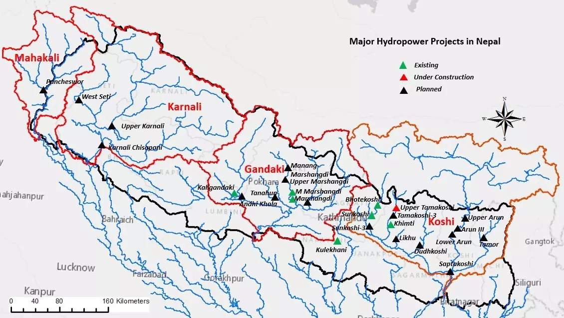
hydropower resources in Nepal
Related Articles
-
Nepal Tibet Map
Nepal and Tibet are located on the south and north side of the Himalayas. Here're practical travel maps of the world's two top tourist destinations. -
Nepal Bhutan Tibet Tour Tips
Nepal Bhutan Tibet tour is a transnational journey. Before this special tour, travelers need to know some tips about permits and visas and attractions. -
How to Plan a Nepal Tibet Bhutan Tour?
Here are some tips for planning a wonderful Nepal Tibet Bhutan tour including regional overviews, required permits and visas, travel routes... -
Lukla: World's Most Dangerous Airport and Gateway to Mt.Everest
Lukla Airport(Tenzing-Hillary Airport) is located in Lukla in eastern Nepal. It is the only gateway from Kathmandu to Mount Everest. -
Top 10 Tourist Places to Visit in Nepal
Nepal is a beautiful country. Hinduism, Buddhism, ancient palaces, as well as rich and colorful natural landscape, constitute its unique tourism resources. -
Grand Festivals and Holidays of Nepal
Festivals of Nepal are an important part of Nepalese traditional culture. Most Nepali festivals originate from the worship of various gods. -
Dashain Festival in Nepal
Dashain is the largest and longest festival in Nepal. It means tenth in Nepali. It is to commemorate the victory of Goddess Durga over Buffalo demon. -
Tihar in Nepal
Tihar, also known as Deepawali or Diwali, is the most beautiful festival in Nepal for driving away darkness with light and defeating evil with goodness. -
Hartalika Teej Festival
Hartalika Teej is a traditional festival celebrated by Hindu women. During the festival, married women would fast and pray for longevity for their husbands. -
Things to Know Before Visiting Nepal
Before you visit Nepal, it is necessary to know some Nepal travel tips including how to get to Nepal, cuisines, things to do, best time to go, etc.
Email response within 0.5~24 hours.