Article

Deconcentration of Industrial Activity as a Constituent of Sustainable Urban Development in a Post-Socialist City: A Case Study of Wroclaw, Poland

Institute of Geography and Regional Development, University of Wroclaw, 50-137 Wroclaw, Poland
*
Author to whom correspondence should be addressed.
Sustainability 2023, 15(20), 14980; https://doi.org/10.3390/su152014980
Submission received: 17 September 2023 / Revised: 13 October 2023 / Accepted: 16 October 2023 / Published: 17 October 2023

Abstract

:
The transformative period following 1989 ushered in significant political and economic changes across Central and Eastern Europe. Among the profound consequences of these shifts were the initiation of suburbanization processes and the uncontrolled expansion of suburbs, particularly around major cities in the region. Suburban zones experienced extensive spatial and functional alterations, while agglomeration centers, the cities themselves, underwent noteworthy transformations. The interplay of land rent dynamics contributed to the reconfiguration of functions within cities, intensifying land use. The aim of this study is to explain the spatial processes of industrial deconcentration within a post-socialist CEE city, using Wroclaw, Poland, as a case study. Employing GIS software, we examine both the spatial patterns and localization of industrial activity within the Wroclaw agglomeration. The research highlights that the peak of industrial deconcentration in the city transpired during the 1990s. Presently, the suburban zone has assumed an increasingly predominant role in the industrial activities within the agglomeration, aligning with the imperatives of sustainable development policies.

1. Introduction

The year 1989 marked the beginning of profound transformations in the spatial structures of Central and Eastern European (CEE) cities. These changes were instigated by the shift from centrally controlled economies to capitalist systems. The collapse of the communist system in the late 1980s and early 1990s played a pivotal role in instigating intense changes in socialist cities [1]. The transformations encompassed social, economic, functional, and spatial dimensions [2,3]. Consequently, a novel urban archetype emerged in Central Europe—the post-socialist city (cf. [4,5,6]). However, Sýkora underlines that the transition from post-socialist cities to capitalist urban mechanisms did not unfold seamlessly or comprehensively [6]. Their development after the collapse of communism exhibited several characteristics that resisted categorization within the prevailing transitional urban model of the time. Furthermore, many facets of this transformation remain incomplete even after three decades [1,6].
This distinctive transformation occurring in post-socialist cities of CEE after 1989 was particularly prominent in urban areas that historically relied on traditional industries. These cities experienced a significant impact from the changes of deindustrialization, deglomeration, and deconcentration of industrial activities, which in turn led to widespread unemployment [7,8,9]. Consequently, post-socialist cities witnessed the emergence of processes such as gentrification, social segregation, and socioeconomic revitalization of specific areas [10,11,12].
As a result of these evolving processes, the functional structure of these cities has undergone significant transformations. Traditional industrial areas, particularly located in central areas, have gradually vanished from the urban landscape of post-socialist cities rooted in traditional industries. In their stead, entities with a service-oriented function (especially commercial), as well as creative industries, or modern industrial entities characterized by reduced spatial demands and lower environmental footprints, have begun to emerge [3,13,14,15,16]. Simultaneously, there has been a notable shift in the ownership structure of production area enterprises. It has entailed a substantial process of commercialization and privatization, accompanied by a wide influx of foreign investment [6,17]. Despite the introduction of these new mechanisms, certain post-socialist cities, grappling with extensive deindustrialization, have experienced challenging socio-demographic and economic conditions, culminating in their urban population decline [18,19].
In addition to the aforementioned internal forces shaping the post-socialist city and affecting its spatial structure since 1989, there were also external processes that pushed traditional spatial patterns from the city center to its suburban zones. These forces were primarily characterized by the processes of both residential and economic suburbanization. Suburbanization, in particular, stands out as one of the extensively examined phenomena in post-socialist urban transformation [1]. The analysis of suburbanization in CEE has been the subject of numerous studies. For instance, Lisowski et al. [20] discussed the influence of suburbanization on urban sprawl in their study of Warsaw, Pichler-Milanović [21] described its effects in Ljubljana, while Stanilov and Hirt [22] conducted research in Sofia, and Kovács et al. [23] analyzed Budapest. These studies consistently reveal specific spatial patterns, with a primary focus on the industrialization of peri-urban areas, often leading to uncontrolled urban sprawl due to a lack of coordinated spatial planning. Consequently, studies examining land use changes in the context of suburbanization include the work of Grigorescu et al. [24], who investigated the largest Romanian agglomerations; Šveda et al. [25], who studied Bratislava; and Stanilov and Sýkora [26], who presented their findings on Prague. The effects of suburbanization on housing and the economy in CEE cities were discussed in studies by Sýkora and Ouředníček [27] in their examination of Prague, Leetmaa et al. [28] in their description of Tallinn, Kubeš [29] in their analysis of Ceskie Budějovice, and Szmytkie [30] who investigated the development of intra-urban suburbs in Wroclaw, Poland. In contrast, industrial deconcentration in post-socialist CEE cities has received less attention in the literature. Economic deconcentration, which includes industrial deconcentration, has been explored by Popescu [31,32] and Săgeată et al. [33,34] in the context of Bucharest and other Romanian cities. Similarly, Szmytkie and Brezdeń [35] conducted studies on Wroclaw, while Sikorski [15,16] provided insights into the natural transition of industrial functions, particularly toward residential functions, within the urban structure. Importantly, most of these studies focused on analyzing changes in the number of employees or business entities within the agglomerations. There is a notable gap in the literature regarding industrial deconcentration on a spatial scale; for instance, by examining shifts in the number and areas of industrial sites and the resulting effects on the urban landscape.
Therefore, we aim to examine the spatial patterns and localization of industrial activity within the functional area of a post-socialist city in CEE after 1989, using the example of Wroclaw, Poland. Based on preliminary observations, we assume that there has been industrial deconcentration within the city structure, leading to the relocation of industries from central areas to internal periphery and suburban zones. In this context, we are particularly interested in capturing the dynamic nature of this phenomenon both in terms of spatial distribution and quantity measures, as well as identifying potential periods of intensified industrial deconcentration. This also involves analyzing the structure of industrial entities, including their scale and the dynamics of land area occupancy. However, we acknowledge certain limitations inherent to this methodological approach. The Polish surveying system lacks consistent updates of cartographic materials and land cover data. Therefore, our research is constrained by the quality and periodic availability of cartographic sources, necessitating the analysis of industrial deconcentration over extended time intervals. Given our focus on the spatial location and size of industrial entities, further interdisciplinary research is essential to refine this approach. Nevertheless, our delineation of processes at the chosen spatial scale will support the ongoing analysis of this subject.

2. Materials and Methods
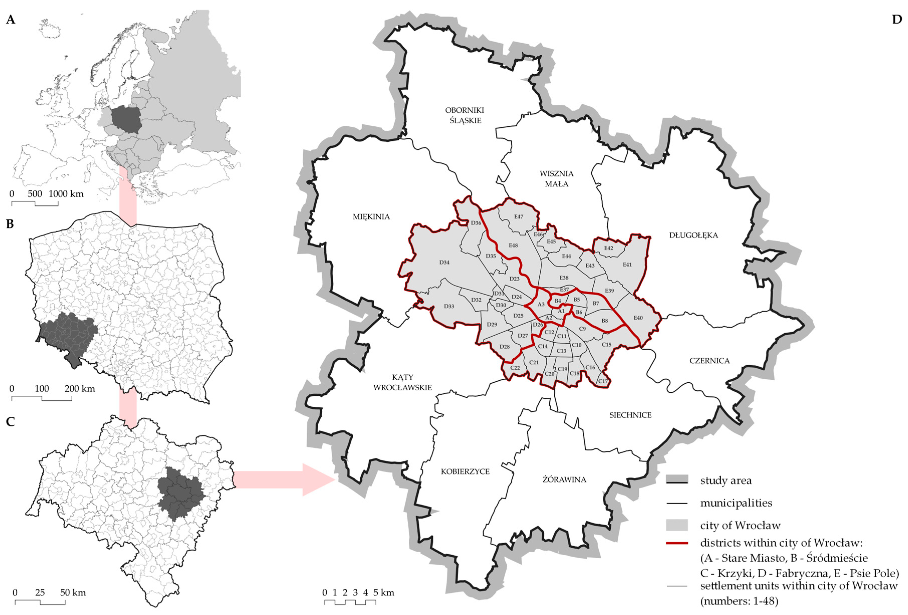
2.1. Study Area

Wroclaw is a large post-socialist city located in Central and Eastern Europe [36], in the southwestern region of Poland and in the eastern part of the Lower Silesian Voivodeship (Figure 1). As of the most recent data from the National Population and Housing Census [37], the city boasts a population of 669,564 residents and covers an area of 292.8 km2. Together with the first ring of municipalities surrounding the city, collectively forming the Wroclaw agglomeration, the total population reaches 857,443 individuals, spread across a land area of 1391.8 km2 [37].
The selection of Wroclaw as the research area stemmed primarily from its status as an exemplary illustration of a city that has traversed the standard trajectory of socio-economic transformation from a socialist to a post-socialist urban center, a characteristic shared by most CEE cities. As previously highlighted, the socio-economic processes and spatial transformations observed in the CEE region exhibit substantial similarities. Given the existing research gap within the Lower Silesia region, our study contributes to enhancing the state of the art by advancing the understanding of the spatial dynamics related to industrial deconcentration.
The city of Wroclaw has undergone numerous political, social, and economic changes throughout its historical evolution [38,39]. Several key historical factors have profoundly shaped the development of the city and its suburban zone, including an advantageous geographic and transportation position (situated at the crossroads of Poland, Germany, and the Czech Republic), proximity to the resource-rich Sudeten mountains, extensive destruction after World War II, where more than 70% of the urban fabric was destroyed, and the period of governance under the communist regime from 1945 to 1989, as detailed by Książek and Szuszczewicz [40].
Wroclaw is a rapidly developing European city. Several predominant phenomena are shaping both its society and spatial landscape. These also include the progressively advancing suburbanization, which manifests in various dimensions [41]. Additionally, there is the ongoing process of industrial deconcentration with the expansion of the service sector [42]. Our study area was delimited to the Wroclaw agglomeration defined as the city of Wroclaw and its suburban zone, encompassing municipalities adjacent to the city’s boundaries. By defining this specific spatial boundary, we can confidently attribute the observed processes to direct interactions occurring along the urban–suburban interface. A segment pertaining to the city of Wroclaw and its immediate surroundings was conducted for the city itself, divided into 48 settlements units grouped into 5 districts, as well as for the suburban zone, which was represented by the 9 municipalities in their administrative boundaries (see Figure 1).

2.2. Research Design

The undertaken research of changes in the industrial location was conducted using a cartographic source change detection method. Additionally, this study was complemented by a statistical analysis of the REGON database (National Official Register of National Economic Entities) in aggregation to urban units.
Cartographic sources in the form of 1:10,000-scale topographic maps were obtained from open source national portal (https://www.geoportal.gov.pl/; accessed on 1 July 2023) and the MAPSTER portal (http://igrek.amzp.pl/; accessed on 2 July 2023) for the period from the 1980s to the present. To streamline the analysis and manage the available maps effectively, it was decided to categorize them into five distinct time periods: the 1980s (comprising topographic sheets of map published between 1981 and 1988) (1), the 1990s (sheets of map published between 1994 and 1998) (2), the 2000s (sheets of map published between 2008 and 2009) (3), the late 2010s (sheets of map published between 2016 and 2018) (4), and the 2020s (sheets of map published in 2023) (5). Each decade since the 1980s has been represented by a single topographic map. After the data collection stage, all maps were georeferenced in the GIS environment. Then, utilizing change detection analysis, the precise locations of each industrial site were identified as belonging to different analytical periods. Employing GIS tools (QGIS Desktop 3.28.8 Firenze), their area (measured in hectares) and distance from the city center of Wroclaw (specifically from the Market Square; measured in meters) were also quantified.
Subsequently, using statistical data sources from the REGON, we identified the number of industrial entities in Wroclaw and its suburban zone for the years 2008–2020, tracking their changes over this period. These data were also used to identify and analyze the migration patterns of industrial entities during the intervals 2008–2012, 2012–2016, and 2016–2020 (Unfortunately, due to the availability and quality of statistical data in Poland, it is impossible to analyze the number of industrial entities for earlier years (before 2008). This subject was more extensively underlined by the authors of [43,44,45,46]).
Utilizing these two primary sources of information, the obtained data enabled us to comprehensively trace the tangible process of industrial deconcentration within the Wroclaw agglomeration from the 1980s to the 2020s. This encompassed the examination of spatial transformations, including alterations in the location and size of industrial areas, as well as economic dynamics, such as shifts in the number of industrial entities. Moreover, it is worth noting that the existing functional links within this delineated area are notably robust, as emphasized by Straszewicz [47].

3. Results

3.1. Dynamics of Spatial Distribution

The total number of industrial sites within the Wroclaw agglomeration increased from 162 to 200, marking a growth of 23.5% over the studied period spanning from the 1980s to the 2020s. However, this growth was not uniform. There was a decline in the number of industrial sites from 136 to 77 (−43.4%) within the city borders. This reduction was particularly evident in the Krzyki district (decrease from 48 to 19; −60.4%) and Psie Pole district (decreasing from 37 to 19, reflecting a decline of 48.6%). In contrast, the suburban zone experienced a substantial increase in the number of industrial sites from 26 to 123 (+373.1%). This expansion was primarily concentrated in municipalities such as Miekinia (increasing from 3 to 31; +933.3%), Katy Wroclawskie (increase from 2 to 18; +800.0%), and Siechnice (increase from 6 to 20; +233.3), as seen in Table 1.
The area of industrial land cover underwent significant changes. In the analyzed period, the industrial land area in the Wroclaw agglomeration increased from 1510.0 ha to 1725.8 ha (+14.3%). However, the city of Wroclaw’s industrial land area decreased from 1366.2 ha to 877.8 ha (−35.8%), mainly in the districts of Fabryczna (−40.1%) and Krzyki (−48.8%). Conversely, the suburban zone experienced a significant expansion in industrial land cover, surging from 143.8 ha to 848.0 ha (+489.8%). This expansion was primarily attributed to industrial land development in municipalities such as Kobierzyce, where the industrial land area increased from 29.0 ha to 288.7 ha (+897.0%) and Katy Wroclawskie, where the industrial sites’ land area increased from 19.7 ha to 140.7 ha (+612.4), as seen in Table 2.
A consequence of the recorded changes in both the quantity and land cover of industrial sites in the Wroclaw agglomeration was their shift in spatial distribution. The spatial distribution of industrial areas followed a concentric pattern, primarily aligning with key transportation networks such as roads, railways, and rivers. However, a discernible trend emerged, marked by the gradual relocation of industry from the city core toward its periphery, particularly within the suburban zone (see Figure 2). It is also of interest to note the distribution of both the size (measured by occupancy area) and number of entities. Over the years, there has been a proliferation of large industrial areas that have established directly along the city’s administrative boundary, such as in the northern part of the Kobierzyce municipality. In quantitative terms, Wroclaw still holds dominance over the suburban zone in terms of the number of industrial enterprises. While these enterprises may be smaller individually, they are numerous and are situated along the linear macroelements of the city’s spatial structure (see kernel density of industrial entities in the 2020s in Figure 2).
The process of industrial deconcentration in the Wroclaw agglomeration is illustrated by changes in the distribution of industrial land area relative to the distance from the city center across the five studied periods (Figure 3). In the 1980s, a substantial portion, approximately 79% of the total industrial areas, was situated within distances ranging from 2001 m to 8000 m from the center of Wroclaw (2001–4000: 36.6%; 4001–6000: 26.0%; 6001–8000: 16.6%), effectively encompassing the city’s administrative boundaries. During this period, only a negligible fraction of industrial land area was recorded within the suburban zone of the agglomeration. In contrast, by the 2020s, the largest proportion of industrial land (comprising 18.5% of the total area) was located between 14,001 m and 16,000 m from the center of the agglomeration, predominantly near the city’s periphery. Currently, only 39.9% of the total industrial land falls within the range of 2001 m–8000 m from the center of Wroclaw. This represents a substantial decline of 39.3 percentage points compared to the 1980s.

3.2. Dynamics of Industrial Entities

The number of industrial entities within the Wroclaw agglomeration increased from 8418 to 9790 (+16.3%) between 2008 and 2020. However, this expansion was not uniform across all areas. In the city of Wroclaw, there was an increase from 7002 to 7476 entities (+6.8%). This growth can be primarily attributed to the Old Town district, which experienced a significant upswing from 897 to 1195 entities, marking a substantial increase of 33.2%, as well as Krzyki where the count increased from 1656 to 1904 entities, reflecting a 15.0% growth. Conversely, the increase was considerably more pronounced within the suburban zone. The number of industrial entities escalated from 1416 to 2314 (+63.4), mainly in the municipalities of Dlugoleka (from 236 to 407; +72.5%) and Kobierzyce (from 144 to 289; +100.7%).
There are significant disparities in terms of industrial entity distribution per square kilometer. In Wroclaw, the density increased on average from 23.9 industrial entities per square kilometer in 2008 to 25.5 in 2020. The Old Town district stands out with the highest density of industrial entities, recording 135 entities per 1 km2 in the 2020s (a density increases of 33.7; +33.2%), as seen in Figure 4A. In contrast, the suburban zone, owing to its expansive area and notably lower population density, exhibits a relatively lower density of industrial entities, amounting to only 1.8 entities per square kilometer in the 2020s (density increase of 0.7; +63.4%). The municipalities of Siechnice (2.9 entities per square kilometer) and Czernica (2.3) reached the highest density of industrial entities (Figure 4B).
When studying the deconcentration of industrial activity, it is also valuable to examine the specific variations in the density within the city itself (Figure 5A) and the dynamics of change (Figure 5B). To achieve this, a parallel analysis was conducted as previously described, but with a focus on smaller units of observation such as settlement units. The density of industrial entities in Wroclaw in 2020 reached its peak values in the city center, notably in settlement unit A1 (462.6 entities per square kilometer), B5 (144.9 entities per square kilometer), and along the main transportation routes, exemplified by neighborhoods no. D27 (89.9), A2 (89.6), and D26 (85.8). Conversely, a gradual shift in the distribution of industrial entity density in the neighborhoods is discernible from 2008 to 2020. The settlement units located on the outskirts of the city were growing, as illustrated by D33 (+170.0%), C18 (+148.3%), or E46 (+122.2%), while the neighborhoods located in the city center were declining in terms of industrial density, as seen in D32 (−38.9%) or D26 (−34.9%). One noteworthy exception is the A1 (Old Town) settlement unit, which recorded an 85.4% increase in the density of industrial entities.
Additional insights into the process of industrial deconcentration can be gleaned from an analysis of the industrial entity migration, which involves changes of registered office address during the following periods: 2008–2012 (A), 2012–2016 (B), and 2016–2020 (C). Across this time frame, a total of 3283 industrial entities altered their registered addresses, comprising 632 entities in (A), 1398 in (B), and 1253 in (C). In the majority of cases, these changes entailed intra-city migrations, amounting to 2476 (75.4%), with 560 in (A), 978 in (B), and 938 in (C). However, a noteworthy 807 industrial entities (24.6% of the total) relocated from the city of Wroclaw to the suburban zone, including 139 in (A), 486 in (B), and 408 in (C), as seen in Figure 6.
Migrations within the study area are significantly influenced by the overall regional economic conditions. Lower Silesia hosts more than 29.8 thousand companies engaged in industrial activities, making up 7.1% of such entities nationwide. In 2019, the total industrial production sales, calculated at current prices and for enterprises employing over nine people in the region, amounted to PLN 135,257.9 million. This figure represented 8.8% of the national total and positioned the region as the fourth highest in the country. This economic vitality was reflected in a per-resident production value of over PLN 48.4 thousand, which exceeded the national average (PLN 42.0 thousand) by 15% [48]. As a result, migrations within the Wroclaw agglomeration are substantially influenced by the broader economic development of the entire region.

4. Discussion

The spatial distribution of the industrial areas within a city and its surroundings is intrinsically linked to the region’s economic development history. In the case of the Wroclaw agglomeration, industrial activity was primarily concentrated within the city’s boundaries, aligning with major transportation routes and the Oder River [49]. Consequently, the spatial distribution of the industry in Wroclaw assumed the pattern of concentration zones, supported by the rationale of the city’s internal and external transportation network. This spatial configuration of industry facilitated the efficient and swift transport of raw materials and semi-finished products, fostering cooperative relationships and predictable technical and technological advantages among individual industries [42]. In the suburban zone, industrial activities played a lesser role [50]. However, with the advent of economic transformations stemming from political changes in CEE since 1989, this arrangement underwent gradual modification.
As demonstrated by this study, the gradual deconcentration of the industry has led to significant modifications in the spatial distribution of industrial areas within the Wroclaw agglomeration. Before 1989, the city of Wroclaw held a dominant position in regional manufacturing activities, accounting for over 80% of the total number of all industrial areas, which occupied more than 90% of the land designated for this type of agglomeration. In the 2020s, Wroclaw encompasses less than 40% of the number of industrial areas, which occupy slightly over 50% of their total area (Table 1 and Table 2). The turning point in rectifying these disparities occurred during the 1990s, marking the period of the most significant changes in the distribution of industrial areas within the Wroclaw agglomeration (Figure 2 and Figure 3).
The patterns of industrial deconcentration in the Wroclaw agglomeration were primarily influenced by the distribution of transportation infrastructure within the region. Municipalities neighboring Wroclaw, where highways or national roads were constructed, witnessed the most significant increase in the number and size of industrial areas (Table 1 and Table 2). Of particular significance in facilitating the relocation of the industry from the city boundaries to the suburban zone was the creation of a modern transportation hub known as the Bielanski Junction during the 1990s (Figure 7). This hub, located in the municipality of Kobierzyce, represents the intersection of the highway and three national roads. This underscores the validity of numerous scientific studies highlighting the pivotal role of highways, national roads, and transportation hubs in attracting both new and existing economic entities [51,52,53].
The deconcentration of industrial activity in the Wroclaw agglomeration was also influenced by phenomena related to the economic processes of the time. Since 1989, Wroclaw and its suburban zone have been undergoing significant transformations of spatial structures, including functional structures, the symptom of which are the observed changes in the distribution of economic entities, largely due to the process of suburbanization and regional economic development [41]. Similar transformations are also taking place in other large agglomerations in Poland [54].
The industrial deconcentration in the Wroclaw agglomeration exhibited a dual dimension. The first, the conventional dimension, involved the shift from the city to the suburban zone. The results obtained are similar or identical to conclusions and regularities noted in other studies of this kind. For example, Brezdeń et al. [54], studying changes in the number and distribution of industrial entities (especially innovative industry) in the Wroclaw and Kraków agglomerations in Poland, noted analogous trends. The only difference in the obtained results is the dynamics of the observed changes, which in the case of the Kraków agglomeration was lower than in the Wroclaw agglomeration, which is likely related to local conditions [54]. The second dimension, which is less apparent, pertained to the movement from the inner settlements to the outer settlements and periphery of Wroclaw (Figure 5A,B). As in the studies conducted by Arauzo [55,56], Sikorski, Szmytkie [41], and Szmytkie [30], this type of deconcentration is relatively common in post-socialist CEE cities. However, it is worth noting and emphasizing that the literature still lacks studies that would prove the previously noted regularities on actual statistical data. The shift of industrial areas to peri-urban zones and the urban expansion throughout the city’s zones can be ascribed to the shift from a centrally planned economy to a free-market system. This transformation has heightened processes such as industrialization, suburbanization, and internal suburbanization, which were previously investigated in the literature [6,19,30]. Kiss contended that the post-1989 restructuring of urban economic systems in CEE cities led to the expansion of industrial areas, as exemplified in Budapest [57].
The processes of shifting industrial activity toward the suburban zone of the agglomeration are multifaceted. On the one hand, the advantages of agglomeration can lead to a concentration of industrial activity, as discussed by researchers like Head [58] and Richardson [59]. On the other hand, an excessive concentration of population and economic activity can result in negative outcomes, such as the inefficiency of communication systems, a lack of available municipal facilities, or infrastructure, as well as environmental degradation, prompting deconcentration processes. This scenario mirrors the situation in Wroclaw. Following the changes in 1989, the city of Wroclaw experienced a period of rapid development, which led to a scarcity of space within the city for production activities. The relocation of industry to other areas represents a natural response by companies to evolving economic conditions. Globally, this phenomenon is associated with a more efficient allocation of resources which, from an economic perspective, is regarded as a positive trend [60]). The deconcentration of industry from Wroclaw to its suburban zone also carries significant environmental and health implications. On the one hand, the decrease in the scale of production activities within the city has positive effects on the well-being of its residents, such as reduced air pollution in densely urbanized areas. On the other hand, the dispersal of industrial land into the suburban zone results in adverse environmental consequences, including diminishing biocapacity and escalating air pollution. These factors have the potential to contribute to health issues among inhabitants who live in scattered settlements [61].
While our study provides crucial insights into the development of industrial entities, we acknowledge some limitations. Unfortunately, assessing persistent changes in development is challenging due to the limited availability of cartographic and statistical sources. The Polish surveying system lacks consistent updates of cartographic materials and land cover data, necessitating the use of periodic analysis. We have employed 10-year intervals in our research, believing that this time frame enables us to effectively capture significant changes in the functional areas of a large city. Furthermore, we are confident that the chosen intervals represented by cartographic maps allowed us to identify trends in the process of industrial deconcentration in the post-socialist CEE city of Wroclaw. This approach has substantiated the emergence of distinct spatial patterns within the study area. Moreover, by analyzing the spatial form of industrial sites, we have laid the foundation for subsequent investigations that can delve into the functional dynamics of industrial development.

5. Conclusions

Based on the conducted research and literature review, the following conclusions can be drawn:
  • The significant deconcentration of industrial activity commenced after 1989, resulting in substantial shifts in industry distribution across the city–suburban zone;
  • The peak of these changes occurred in the 1990s, driven more by the decline of unprofitable industrial activities within the city [15] than by a deliberate deconcentration strategy;
  • The requirements for industry deconcentration began to gain importance in the economic and spatial policies of CEE countries only in the late 1990s [62], leading to the gradual implementation of the idea of sustainable urban development;
  • The processes of industrial deconcentration in post-socialist cities are ongoing, although not at the same scale as in earlier years.
After 1989, the process of industrial deconcentration became a widespread phenomenon in most post-socialist CEE cities. However, the specifics of this process varied depending on local and regional characteristics, as well as global factors. One significant contribution of this research lies in its granularity and the utilization of spatial data, particularly in the analysis of the number and size of industrial sites. Consequently, this study provides compelling evidence of deconcentration occurring within the investigated city, with its most pronounced dynamics observed during the 1990s. Nevertheless, it is important to acknowledge that this type of research has limitations, primarily stemming from the absence of data that would enable a more detailed examination of the deconcentration process.

Author Contributions

Conceptualization, D.S.; methodology, D.S. and P.K.; software, D.S. and P.K.; validation, D.S. and P.K.; formal analysis, D.S.; investigation, D.S. and P.K.; resources, D.S. and P.K.; data curation, D.S. and P.K.; writing—original draft preparation, D.S.; writing—review and editing, P.K.; visualization, D.S. and P.K.; supervision, D.S.; project administration, D.S. All authors have read and agreed to the published version of the manuscript.

Funding

This research received no external funding.

Institutional Review Board Statement

Not applicable.

Informed Consent Statement

Not applicable.

Data Availability Statement

Data sharing not applicable.

Conflicts of Interest

The authors declare no conflict of interest.

References

  1. Cudny, W.; Kunc, J. (Eds.) Growth and Change in Post-Socialist Cities of Central Europe; Routledge: London, UK; New York, NY, USA, 2022. [Google Scholar]
  2. Kovács, Z. Cities from state-socialism to global capitalism: An introduction. GeoJournal 1999, 49, 1–6. Available online: https://www.jstor.org/stable/41147394 (accessed on 1 September 2023). [CrossRef]
  3. Cudny, W. Socio-Economic Changes in Lodz—Results of Twenty Years of System Transformation. Geogr. Časopis 2012, 64, 3–27. [Google Scholar]
  4. Liszewski, S. Model przemian przestrzeni miejskiej miasta postsocjalistycznego. In Miasto Postsocjalistyczne—Organizacja Przestrzeni Miejskiej i Jej Przemiany; Jazdzewska, I., Ed.; Konwersatorium Wiedzy o Mieście 2001, XIV; Uniwersytetu Łódzkiego: Łódź, Poland, 2001; pp. 303–310. [Google Scholar]
  5. Ondoš, S.; Korec, P. The rediscovered city: A case study of post-socialist Bratislava. Geogr. Cas. 2008, 60, 199–213. [Google Scholar]
  6. Sýkora, L. Post-socialist cities. In International Encyclopedia of Human Geography; Kitchin, R., Thrift, N., Eds.; Elsevier: Oxford, UK, 2009; pp. 387–395. [Google Scholar] [CrossRef]
  7. Jürgens, U. City profile Leipzig. Cities 1996, 13, 37–43. [Google Scholar] [CrossRef]
  8. Mulícek, O.; Toušek, V. Changes of Brno industry and their urban consequences. Bull. Geogr. 2004, 3, 61–70. [Google Scholar] [CrossRef]
  9. Osman, R.; Frantál, B.; Klusácek, P.; Kunc, J.; Martinát, S. Factors affecting brownfield regeneration in post-socialist space: The case of the Czech Republic. Land Use Policy 2015, 48, 309–316. [Google Scholar] [CrossRef]
  10. Kovács, Z.; Wiessner, R.; Zischner, R. Urban renewal in the inner city of Budapest: Gentrification from a post-socialist perspective. Urban Stud. 2013, 50, 22–38. [Google Scholar] [CrossRef]
  11. Kaczmarek, S. Skuteczność procesu rewitalizacji. Uwarunkowania, mierniki, perspektywy. Stud. Miej. 2015, 17, 27–35. Available online: http://www.studiamiejskie.uni.opole.pl/wp-content/uploads/2016/05/S_Miejskie_17_2015-Kaczmarek.pdf (accessed on 2 September 2023).
  12. Holm, A.; Marcińczak, S.; Ogrodowczyk, A. New-build gentrification in the postsocialist city: Łodź and Leipzig two decades after socialism. Geografie 2015, 120, 164–187. [Google Scholar] [CrossRef]
  13. Chapain, C.; Stryjakiewicz, T. (Eds.) Creative Industries in Europe: Drivers of New Sectoral and Spatial Dynamics; Springer: Cham, Switzerland, 2017. [Google Scholar]
  14. Chaloupková, M.; Kunc, J.; Dvorák, Z. The creativity index growth rate in the czech republic: A spatial approach. Geogr. Tech. 2018, 13, 30–40. [Google Scholar] [CrossRef]
  15. Sikorski, D. Proces sukcesji funkcjonalnej na terenach przemysłowych i poprzemysłowych w miastach województwa dolnośląskiego. In Studium Przypadków, Wydawnictwo Uczelniane PWSZ im; A Silesiusa: Wałbrzych, Poland, 2013. [Google Scholar]
  16. Sikorski, D. Wybrane Kierunki i Aspekty Przemian Funkcjonalnych Terenów Przemysłowych we Wrocławiu w Latach 1989–2016; Prace Komisji Geografii Przemysłu PTG: Warsaw, Poland, 2019; Volume 33, pp. 227–240. [Google Scholar] [CrossRef]
  17. Jacobs, A. The Bratislava metropolitan region. Cities 2013, 31, 507–514. [Google Scholar] [CrossRef]
  18. Bucek, J.; Bleha, B. Urban shrinkage as a challenge to local development planning in Slovakia. Morav. Geogr. Rep. 2013, 21, 2–15. [Google Scholar] [CrossRef]
  19. Rink, D.; Couch, C.; Haase, A.; Krzysztofik, R.; Nadolu, B.; Rumpel, P. The governance of urban shrinkage in cities of post-socialist Europe: Policies, strategies and actors. Urban Res. Pract. 2014, 7, 258–277. [Google Scholar] [CrossRef]
  20. Lisowski, A.; Mantey, D.; Wilk, W. Lessons from Warsaw: The lack of co-ordinated planning and its impacts on urban sprawl. In Confronting Suburbanization: Urban Decentralization in Postsocialist Central and Eastern Europe; Stanilova, K., Sýkora, L., Eds.; Wiley-Blackwe: Oxford, UK, 2014; pp. 225–255. [Google Scholar] [CrossRef]
  21. Pichler-Milanović, N. Confronting suburbanization in Ljubljana: From “urbanization of the countryside” to urban sprawl. In Confronting Suburbanization: Urban Decentralization in Postsocialist Central and Eastern Europe; Stanilova, K., Sýkora, L., Eds.; Wiley-Blackwe: Oxford, UK, 2014; pp. 65–96. [Google Scholar] [CrossRef]
  22. Stanilov, K.; Hirt, S. Sprawling Sofia: Postsocialist suburban growth in the Bulgarian capital, In Confronting Suburbanization: Urban Decentralization in Postsocialist Central and Eastern Europe; Stanilova, K., Sýkora, L., Eds.; Wiley-Blackwe: Oxford, UK, 2014; pp. 163–191. [Google Scholar] [CrossRef]
  23. Kovács, Z.; Farkas, J.Z.; Egedy, T.; Kondor, A.C.; Szabó, B.; Lennert, J.; Baka, D.; Kohán, B. Urban sprawl and land conversion in post-socialist cities: The case of metropolitan Budapest. Cities 2019, 92, 71–81. [Google Scholar] [CrossRef]
  24. Grigorescu, I.; Mitrica, B.; Kucsicsa, G.; Popovici, E.A.; Dumitrascu, M.; Cuculici, R. Post-communist land use changes related to urban sprawl in the Romanian metropolitan areas. Hum. Geogr. J. Stud. Res. Hum. Geogr. 2012, 6, 35–46. [Google Scholar] [CrossRef]
  25. Šveda, M.; Madajová, M.; Podolák, P. Behind the differentiation of suburban development in the hinterland of Bratislava, Slovakia. Czech Sociol. Rev. 2016, 52, 893–925. Available online: https://www.jstor.org/stable/44817689 (accessed on 2 September 2023). [CrossRef]
  26. Stanilov, K.; Sýkora, L. Planning markets, and patterns of residential growth in metropolitan Prague. J. Archit. Plan. Res. 2012, 29, 278–291. Available online: https://www.jstor.org/stable/43030982 (accessed on 3 September 2023).
  27. Sýkora, L.; Ouředníček, M. Sprawling post-communist metropolis: Commercial and residential suburbanization in Prague and Brno, the Czech Republic. In Employment Deconcentration in European Metropolitan Areas; Razin, E., Dijst, M., Vazquez, C., Eds.; Springer: Dordrecht, The Netherlands, 2007; pp. 209–233. [Google Scholar] [CrossRef]
  28. Leetmaa, K.; Kährik, A.; Nuga, M.; Tammaru, T. Suburbanization in the Tallinn Metropolitan Area. In Confronting Suburbanization: Urban Decentralization in Postsocialist Central and Eastern Europe; Stanilova, K., Sýkora, L., Eds.; Wiley-Blackwe: Oxford, UK, 2014; pp. 192–224. [Google Scholar]
  29. Kubeš, J. Analysis of regulation of residential suburbanisation in hinterland of postsocialist ‘one hundred thousands’ city of Ceske Budejovice. Bull. Geogr. 2015, 27, 109–131. [Google Scholar] [CrossRef]
  30. Szmytkie, R. Suburbanisation processes within and outside the city: The development of intra-urban suburbs in Wrocław, Poland. Morav. Geogr. Rep. 2021, 29, 149–165. [Google Scholar] [CrossRef]
  31. Popescu, C. Deindustrialization and Urban Shrinkage in Romania What Lessons for the Spatial Policy? Transylv. Rev. Adm. Sci. 2014, 10, 181–202. [Google Scholar]
  32. Popescu, C. After deindustrialisation: Changing urban economy in the Danube valley region. Hum. Geogr. J. Stud. Res. Hum. Geogr. 2016, 10, 99–113. [Google Scholar] [CrossRef]
  33. Săgeată, R. Commercial services and urban space reconversion in Romania (1990–2007). Acta Geogr. Slov. 2020, 60, 49–60. [Google Scholar] [CrossRef]
  34. Săgeată, R.; Mitrică, B.; Cercleux, A.-L.; Grigorescu, I.; Hardi, T. Deindustrialization, Tertiarization and Suburbanization in Central and Eastern Europe. Lessons Learned from Bucharest City. Rom. Land 2023, 12, 1731. [Google Scholar] [CrossRef]
  35. Brezdeń, P.; Szmytkie, R. Current Changes in the Location of Industry in the Suburban Zone of A Post-Socialist City. Case Study of Wrocław (Poland). Tijdschr. Voor Econ. En Soc. Geogr. 2019, 110, 102–122. [Google Scholar] [CrossRef]
  36. Hamilton, F.E.I.; Andrews, K.; Pichler-Milanović, N. (Eds.) Transformation of Cities in Central and Eastern Europe: Towards Globalization; United Nations University Press: Tokyo, Japan, 2005; Available online: https://chisineu.files.wordpress.com/2012/08/biblioteca_hamilton_transformation.pdf (accessed on 2 September 2023).
  37. Główny Urząd Statystyczny. National Population and Housing Census (in Polish: Narodowy Spis Powszechny Ludności i Mieszkań); Główny Urząd Statystyczny: Warszawa, Poland, 2021.
  38. Kulak, T. Historia Wrocławia. Tom II: Od Twierdzy Fredyrecjańskiej do Twierdzy Hitlerowskiej; Wydawnictwo Dolnośląskie: Wrocław, Poland, 2001. [Google Scholar]
  39. Kulak, T. Wrocław. In Przewodnik Historyczny; Wydawnictwo Dolnośląskie: Wrocław, Poland, 2006. [Google Scholar]
  40. Książek, S.; Suszczewicz, M. City profile: Wrocław. Cities 2017, 65, 51–65. [Google Scholar] [CrossRef]
  41. Sikorski, D.; Szmytkie, R. Changes in the distribution of economic activity in Wrocław and its suburban area, 2008–2016. Bull. Geogr. 2019, 54, 33–48. [Google Scholar] [CrossRef]
  42. Kunc, J.; Sikorski, D.; Novotná, M.; Brezdeń, P.; Ilnicki, D.; Tonev, P.; Marek, A. Industrial legacy towards modern urban environment: A comparative study of Wroclaw and Brno. Bull. Geogr. Socio-Econ. Ser. 2023, 61, 71–92. [Google Scholar] [CrossRef]
  43. Ilnicki, D. Statystyczna i rzeczywista przestrzeń instytucjonalna miasta. In Struktura Funkcjonalna Małych Miast; Marszał, T., Ed.; Wydawnictwo Uniwersytetu Łódzkiego: Łódź, Poland, 2009; pp. 115–137. [Google Scholar]
  44. Raczyk, A. Metody badania przedsiębiorczości oparte na rejestrze podmiotów gospodarki narodowej. In Rola Przedsiębiorczości w Kształtowaniu Społeczeństwa Informacyjnego; Zioło, T., Rachwał, T., Eds.; Przedsiębiorczość-Edukacja: Szczecin, Poland, 2009; Volume 5, pp. 133–146. [Google Scholar]
  45. Śleszyński, P. Studium szacunku liczby i rozmieszczenia pracujących w Krakowie. Biul. Kpzk PAN 2010, 243, 5–102. [Google Scholar]
  46. Celińska-Janowicz, D. Rejestry podmiotów jako źródła danych w analizach lokalizacji działalności gospodarczej w mikroskali. Wiadomości Stat. 2016, 1, s27–s43. Available online: http://cejsh.icm.edu.pl/cejsh/element/bwmeta1.element.desklight-ec3378c6-f2fb-4907-b24e-8bfa2f1349bf (accessed on 3 September 2023).
  47. Straszewicz, L. Strefa podmiejska. Pojęcia i definicje. Acta Univ. Lodz. Folia Geogr. 1985, 5, 7–16. [Google Scholar]
  48. Zathey, M.; Wałęga, A.; Acedońska, K.; Balachowski, J.; Cieślak, R.; Drewnicka, K.; Halicka-Borucka, M.; Kasprzak, M.; Książek, S.; Kukuła, M.; et al. Analiza gospodarcza Dolnego Śląska 2021; Instytut Rozwoju Terytorialnego: Wrocław, Poland, 2021. [Google Scholar]
  49. Slenczek, M. Miasto Wrocław Jako Ośrodek Przemysłowy; Acta Universitatis Wratislaviensis, Prace Instytutu Geograficznego. Ser. B Geogr. Społeczna I Ekon. 1996, 14, 85–91. [Google Scholar]
  50. Slenczek, M. Rozwój i przemiany przemysłu na Dolnym Śląsku. In Przemiany Ludnościowo-Osadnicze i Społeczno-Gospodarcze na Dolnym Śląsku po II Wojnie Światowej; Łoboda, J., Ed.; Acta Universitatis Wratislaviensis. Studia Geograficzne; Wydawnictwo Uniwersytetu Wrocławskiego: Wrocław, Poland, 1994; Volume 61, pp. 99–131. [Google Scholar]
  51. Eagle, D.; Stephanedes, J.Y. Dynamic Highway Impacts on Economic Development. Transp. Res. Rec. 1967, 1116, 56–62. [Google Scholar]
  52. Rephanna, T.; Isserman, A. New highways as economic development tools: An evaluation using quasi-experimental matching methods. Reg. Sci. Urban Econ. 1994, 24, 723–751. [Google Scholar] [CrossRef]
  53. Wang, W. Empirical Study on the Relationship between Highway Construction and Economic Growth Based on Big Data Analysis. J. Phys. Conf. Ser. 2021, 1744, 032011. [Google Scholar] [CrossRef]
  54. Brezdeń, P.; Sikorski, D.; Smętkiewicz, K. Spatial structure of industry according to R&D intensity during the economic crisis. An example of changes taking place in the Krakow and Wroclaw agglomerations during 2018–2021. Stud. Ind. Geogr. Comm. Pol. Geogr. Soc. 2023, 37, 46–69. [Google Scholar] [CrossRef]
  55. Arauzo, J.M. Determinants of industrial location an application for Catalan municipalities. Pap. Reg. Sci. 2005, 84, 105–120. [Google Scholar] [CrossRef]
  56. Arauzo-Carod, J.M. Location determinants of high-tech firms: An intra-urban approach. Ind. Innov. 2021, 28, 1225–1248. [Google Scholar] [CrossRef]
  57. Kiss, E. The Evolution of Industrial Areas in Budapest after 1989. In The Post-Socialist City: Urban Form and Space Transformations in Central and Eastern Europe after Socialism; Stanilov, K., Ed.; Springer: Dordrecht, The Netherlands, 2007; pp. 147–170. [Google Scholar] [CrossRef]
  58. Head, K.; Ries, J.; Swenson, D. Agglomeration benefits and location choice: Evidence from Japanese manufacturing investments in the United States. J. Int. Econ. 1995, 38, 223–247. [Google Scholar] [CrossRef]
  59. Richardson, H.W. Economies and Diseconomies of Agglomeration. In Urban Agglomeration and Economic Growth; Gierstch, H., Ed.; Springer: Berlin/Heidelberg, Germany, 1995; pp. 123–155. [Google Scholar]
  60. Sikorski, D.; Brezdeń, P. Contemporary Processes of Concentration and Specialization of Industrial Activity in Post-Socialist States as Illustrated by the Case of Wrocław and Its Suburbs (Poland). Land 2021, 10, 1140. [Google Scholar] [CrossRef]
  61. Bronder, J.; Gorgoń, J.; Cenowski, M. Raport: Opracowanie Dotyczące Występowania Powierzchniowej Miejskiej Wyspy Ciepła dla Obszaru Miasta Wrocław; Urząd Miejski we Wrocławiu: Wrocław, Polska, 2021; pp. 1–52. Available online: https://bip.um.wroc.pl/artykuly/1081/miejska-wyspa-ciepla-dla-obszaru-miasta-wroclaw (accessed on 2 September 2023).
  62. Słodczyk, J. Przestrzeń Miast i jej Przeobrażenia; Uniwersytet Opolski: Opole, Poland, 2001. [Google Scholar]
Figure 1. Study area (D) on the background of Europe (A), Poland (B), and Lower Silesia Voivodeship (C). Note: Names of settlement units: A1: Stare Miasto, A2: Przedmiescie Swidnickie, A3: Szczepin, B4: Nadodrze, B5: Olbin, B6: Plac Grunwaldzki, B7: Zacisze—Zalesie—Szczytniki, B8: Biskupin—Sepolno—Dabie—Bartoszowice, C9: Przedmiescie Olawskie, C10: Tarnogaj, C11: Huby, C12: Powstancww Sląskich, C13: Gaj, C14: Borek, C15: Ksieze, C16: Brochow, C17: Bienkowice, C18: Jagodno, C19: Wojszyce, C20: Oltaszyn, C21: Krzyki—Partynice, C22: Klecina, D23: Pilczyce—Kozanow—Popowice Pln., D24: Gadow—Popowice Pld., D25: Muchobor Maly, D26: Gajowice, D27: Grabiszyn—Grabiszynek, D28: Oporow, D29: Muchobor Wielki, D30: Nowy Dwor, D31: Kuzniki, D32: Zerniki, D33: Jerzmanowo—Jarnoltiw—Strachowice—Osiniec, D34: Lesnica, D35: Maslice, D36: Pracze Odrzanskie, E37: Kleczkow, E38: Karlowice—Rozanka, E39: Kowale, E40: Strachocin—Swojczyce—Wojnow, E41: Psie Pole—Zawidawie, E42: Pawlowice, E43: Soltysowice, E44: Polanowice—Poswiętne—Ligota, E45: Widawa, E46: Lipa Piotrowska, E47: Swiniary, E48: Osobowice—Redzin.
Sustainability 15 14980 g001
Figure 2. Changes in the distribution of industrial sites in the Wroclaw agglomeration from the 1980s to the 2020s.
Sustainability 15 14980 g002
Figure 3. Changes in the distribution of industrial land cover as a function of distance from the city center within Wroclaw agglomeration from the 1980s to the 2020s.
Sustainability 15 14980 g003
Figure 4. The number of industrial entities per square kilometer in 2020 (A) and the dynamics of its change in the Wroclaw agglomeration in 2008–2020 (B).
Sustainability 15 14980 g004
Figure 5. The number of industrial entities per square kilometer in 2020 (A) and the dynamics of its change in settlement units in Wroclaw from 2008 to 2020 (B).
Sustainability 15 14980 g005
Figure 6. Migration of industrial entities in the Wroclaw agglomeration in 2008–2012 (A), 2012–2016 (B), and 2016–2020 (C).
Sustainability 15 14980 g006
Figure 7. Spatial development (AD) of Bielanski Junction since the 1990s (A) to the 2020s (D).
Sustainability 15 14980 g007
Table 1. The number of industrial sites in the Wroclaw agglomeration from the1980s to the 2020s.
Area1980s1990s2000s2010s2020s1980s–2020s
(Number)(Number)(%)
Suburban zoneCzernica02788+8-
Dlugoleka612131213+7+116.7
Katy Wroclawskie2381618+16+800.0
Kobierzyce512181113+8+160.0
Miekinia36202731+28+933.3
Oborniki Slaskie35527+4+133.3
Siechnice610182020+14+233.3
Wisznia Mala13666+5+500.0
Zorawina00667+7-
City of WroclawFabryczna3948272932−7−17.9
Krzyki4860191819−29−60.4
Psie Pole3758201919−18−48.6
Stare Miasto88555−3−37.5
Srodmiescie49222−2−50.0
suburban zone2653101108123+97+373.1
city of Wroclaw136184737377−59−43.4
total162237174181200+38+23.5
Table 2. The area of industrial sites in the Wroclaw agglomeration from the1980s to the 2020s.
Area1980s1990s2000s2010s2020s1980s–2020s
(ha)(ha)(%)
Suburban zoneCzernica0.02.011.312.712.7+12.7-
Dlugoleka30.445.169.778.879.8+49.4+162.3
Katy Wroclawskie19.724.539.6102.7140.7+120.9+612.4
Kobierzyce29.061.9290.1286.5288.7+259.8+897.0
Miekinia9.819.172.983.3102.0+92.2+940.1
Oborniki Slaskie6.37.215.84.425.0+18.7+296.4
Siechnice46.750.481.0136.9136.7+90.0+192.9
Wisznia Mala1.94.17.97.97.9+6.0+319.2
Zorawina0.00.019.928.154.5+54.5-
City of WroclawFabryczna489.9493.8251.2277.9293.3−196.6−40.1
Krzyki283.4315.3145.2144.4145.2−138.2−48.8
Psie Pole355.5426.4338.2375.5375.5+20.0+5.6
Stare Miasto107.776.643.843.943.9−63.8−59.2
Srodmiescie129.8130.652.652.619.9−109.9−84.7
suburban zone143.8214.3608.1741.3848.0+704.2+489.8
city of Wroclaw1366.21441.0830.8894.3877.8−488.5−35.8
total1510.01655.31439.01635.71725.8+215.8+14.3
Disclaimer/Publisher’s Note: The statements, opinions and data contained in all publications are solely those of the individual author(s) and contributor(s) and not of MDPI and/or the editor(s). MDPI and/or the editor(s) disclaim responsibility for any injury to people or property resulting from any ideas, methods, instructions or products referred to in the content.

