


<< Our Photo Pages >> Woodhead Round Cairn - Round Cairn in England in Cumbria
Submitted by Anne T on Wednesday, 01 February 2017 Page Views: 1208
Neolithic and Bronze AgeSite Name: Woodhead Round Cairn Alternative Name: Woodhead Cairn and Hut Circle; Askerton Round CairnCountry: England County: Cumbria Type: Round Cairn
Nearest Town: Carlisle Nearest Village: Bewcastle
Map Ref: NY58507402
Latitude: 55.058917N Longitude: 2.65123W
Condition:
| 5 | Perfect |
| 4 | Almost Perfect |
| 3 | Reasonable but with some damage |
| 2 | Ruined but still recognisable as an ancient site |
| 1 | Pretty much destroyed, possibly visible as crop marks |
| 0 | No data. |
| -1 | Completely destroyed |
| 5 | Superb |
| 4 | Good |
| 3 | Ordinary |
| 2 | Not Good |
| 1 | Awful |
| 0 | No data. |
| 5 | Can be driven to, probably with disabled access |
| 4 | Short walk on a footpath |
| 3 | Requiring a bit more of a walk |
| 2 | A long walk |
| 1 | In the middle of nowhere, a nightmare to find |
| 0 | No data. |
| 5 | co-ordinates taken by GPS or official recorded co-ordinates |
| 4 | co-ordinates scaled from a detailed map |
| 3 | co-ordinates scaled from a bad map |
| 2 | co-ordinates of the nearest village |
| 1 | co-ordinates of the nearest town |
| 0 | no data |
Internal Links:
External Links:
I have visited· I would like to visit
SumDoood would like to visit
")
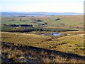
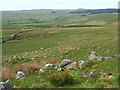
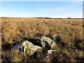
This round cairn and hut circle lie within about 20 metres of each other on a gently sloping hillside, 800 metres east of Woodhead, above Green's Burn, about 100 metres east of the Natural England footpath through this area.
Listed as Historic England Entry 1015729, the round cairn is clearly visible as a 1 metre tall oval mound of turf covered stones on the slope on the far side of the burn from the footpath. The Historic England entry tells us the mound is some 6m north-south by 5.5m east-west.
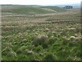
Just to the north of the cairn lies a hut circle, also with foundation walls up to 1 metre tall. It lies mostly hidden in grass until you come across it amongst the tussocks of grass, when it's structure becomes clear. The Historic England entry says that on it's northern side "the hut's floor has been cut into the hillside, to form a flat living surface. There is an entrance on the south west side of the hut .... Limited excavation of the hut circle in 1939 found a hearthstone to the right of the entrance and two shallow holes cut into the floor of the hut. These are thought to have contained poles supporting a roof of skins. Other finds included a stone button, a stone ring, and a flint flake."
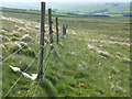
Nearby are the remains of a well preserved lime kiln, together other hut circles and shielings. Lying close to St. Cuthbert's at Bewcastle with it's famous cross, parking is available just off the road at NY 56569 74287. Follow the right hand trackway signposted to The Bush and High Grains (this is a Natural England permissive footpath). Just after Rigghead and Woodhead farms, turn right by the sheep pens/caravan and follow the track through a small forested area. The path then splits - right to a modern quarry; left past the lime kilns and some impressive shakeholes. Where the footpath then turns a sharp left, follow the track downhill for some 100 yards then head off right across the burn (easily crossed at this point). The round cairn is some 20-30 metres up this slope, with the hut circle some 10 metres north.
You may be viewing yesterday's version of this page. To see the most up to date information please register for a free account.
")
")
")
Do not use the above information on other web sites or publications without permission of the contributor.
Nearby Images from Geograph Britain and Ireland:
©2016(licence)
©2008(licence)
©2008(licence)
©2008(licence)
©2016(licence)
The above images may not be of the site on this page, they are loaded from Geograph.
Please Submit an Image of this site or go out and take one for us!
Click here to see more info for this site
Nearby sites
Key: Red: member's photo, Blue: 3rd party photo, Yellow: other image, Green: no photo - please go there and take one, Grey: site destroyed
Download sites to:
KML (Google Earth)
GPX (GPS waypoints)
CSV (Garmin/Navman)
CSV (Excel)
To unlock full downloads you need to sign up as a Contributory Member. Otherwise downloads are limited to 50 sites.
Turn off the page maps and other distractions
Nearby sites listing. In the following links * = Image available
2.0km WNW 285° Priest's Well (Bewcastle)* Holy Well or Sacred Spring (NY56607454)
2.0km SW 233° Towerbrae Cairn* Cairn (NY56867282)
2.0km WNW 285° Bewcastle Cross* Ancient Cross (NY5653574550)
2.5km NNW 332° Grey Hill Settlement Ancient Village or Settlement (NY57317626)
2.5km SSW 198° Robin Hood's Well (Askerton) Holy Well or Sacred Spring (NY57677161)
3.1km NW 313° Hobbie Nobles Well (Bewcastle) Holy Well or Sacred Spring (NY5624076200)
3.5km SSW 203° Gillalees Ring Cairn (NY571708)
4.6km SW 220° Askerton Park* Ancient Village or Settlement (NY55567053)
5.8km S 169° Waterhead Holy Well (King Water)* Holy Well or Sacred Spring (NY5951068340)
6.4km ESE 108° Standingstone Rigg Standing Stone (Cumbria) Standing Stone (Menhir) (NY6458271969)
7.7km SE 139° Popping Stone* Natural Stone / Erratic / Other Natural Feature (NY63556815)
8.0km SE 141° Gilsland Spa Sulphur Spring Holy Well or Sacred Spring (NY63476776)
8.0km SE 140° Gilsland Spa Well* Holy Well or Sacred Spring (NY6354067815)
8.6km WSW 250° Bride's Well (Stapleton)* Holy Well or Sacred Spring (NY50397119)
9.2km SSE 147° Hadrian's Wall (Poltross Burn)* Stone Fort or Dun (NY6340166198)
9.4km S 186° Banks East Ancient Village or Settlement (NY574647)
11.4km SSW 213° St Mary's Church (Walton)* Ancient Cross (NY5220864492)
12.1km SE 127° King Arthur's Well (Walltown Gap)* Holy Well or Sacred Spring (NY68066664)
12.1km W 277° Holywell (Catlowdy)* Holy Well or Sacred Spring (NY4649175570)
12.1km SE 127° Hadrian's Wall (Turret 44b)* Misc. Earthwork (NY6813866704)
12.2km W 276° Solport Holy Well (Catlowdy) Holy Well or Sacred Spring (NY4637075490)
13.0km WNW 282° Priest's Well (Catlowdy)* Holy Well or Sacred Spring (NY4573976887)
13.7km SSW 202° Brampton Castle Mound and Well* Misc. Earthwork (NY5333261284)
13.8km SSE 157° Hartleyburn Common 1c Rock Art (NY6387161326)
13.8km SSE 157° Hartleyburn Common 1d Rock Art (NY6387361324)
View more nearby sites and additional images


 We would like to know more about this location. Please feel free to add a brief description and any relevant information in your own language.
 Wir möchten mehr über diese Stätte erfahren. Bitte zögern Sie nicht, eine kurze Beschreibung und relevante Informationen in Deutsch hinzuzufügen.
 Nous aimerions en savoir encore un peu sur les lieux. S'il vous plaît n'hesitez pas à ajouter une courte description et tous les renseignements pertinents dans votre propre langue.
 Quisieramos informarnos un poco más de las lugares. No dude en añadir una breve descripción y otros datos relevantes en su propio idioma.