


<< Our Photo Pages >> Newton Mulgrave Moor RB1 - Round Barrow(s) in England in Yorkshire (North)
Submitted by johndhunter on Wednesday, 17 January 2024 Page Views: 101
Neolithic and Bronze AgeSite Name: Newton Mulgrave Moor RB1Country: England County: Yorkshire (North) Type: Round Barrow(s)
Nearest Town: Whitby Nearest Village: Ellerby / Mickleby
Map Ref: NZ7847913526
Latitude: 54.510976N Longitude: 0.789378W
Condition:
| 5 | Perfect |
| 4 | Almost Perfect |
| 3 | Reasonable but with some damage |
| 2 | Ruined but still recognisable as an ancient site |
| 1 | Pretty much destroyed, possibly visible as crop marks |
| 0 | No data. |
| -1 | Completely destroyed |
| 5 | Superb |
| 4 | Good |
| 3 | Ordinary |
| 2 | Not Good |
| 1 | Awful |
| 0 | No data. |
| 5 | Can be driven to, probably with disabled access |
| 4 | Short walk on a footpath |
| 3 | Requiring a bit more of a walk |
| 2 | A long walk |
| 1 | In the middle of nowhere, a nightmare to find |
| 0 | No data. |
| 5 | co-ordinates taken by GPS or official recorded co-ordinates |
| 4 | co-ordinates scaled from a detailed map |
| 3 | co-ordinates scaled from a bad map |
| 2 | co-ordinates of the nearest village |
| 1 | co-ordinates of the nearest town |
| 0 | no data |
Internal Links:
External Links:
")
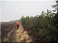
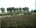
A bronze age gorse covered round barrow which at present (2023) lies within a small cleared area at the very western edge of Newton Mulgrave Woods, separated from the moor by fencing.
It is made of earth and stone, 8m in diameter and about 0.5m in height. Gorse covered it is actually difficult to make anything out and my main means of identifying was its gps location and the obvious rise in the ground when one got close to it. I had looked for this barrow on a previous visit some ten years earlier in 2013 but was unable to locate it, I can’t remember why but probably because I did not have an accurate grid ref, though I doubt the gorse would have been as it is now. Also I noticed on this visit (2023) that young saplings have been planted around it and in the rest of the cleared area, so should be well hidden in years to come.
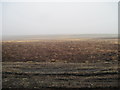
Official records talk about sub rectangular stones being dislodged from the the centre of mound by the plough when they planted the plantation. I could not see these, if still there they may be under the gorse. However the furrows from the plough as mentioned in official records are still there and were a help in identifying the barrow.
Just pondering: Not sure why they called the plantation in this area Newton Mulgrave Woods as the vast majority of it is in Ellerby civil parish to the north and Mickleby civil parish to the south. However by the same token, strictly speaking the barrow being just to the east of the parish boundary line puts it on Ellerby Moor rather than Newton Mulgrave Moor but as it belongs to a group of barrows designated as a barrow cemetery on Newton Mulgrave Moor I have named it accordingly.
Sources:
HERR MONUMENT 29082
Historic England LIST ENTRY 1016571
You may be viewing yesterday's version of this page. To see the most up to date information please register for a free account.
")
")
")
Do not use the above information on other web sites or publications without permission of the contributor.
Nearby Images from Geograph Britain and Ireland:
©2013(licence)
©2006(licence)
©2013(licence)
©2007(licence)

©2008(licence)
The above images may not be of the site on this page, they are loaded from Geograph.
Please Submit an Image of this site or go out and take one for us!
Click here to see more info for this site
Nearby sites
Key: Red: member's photo, Blue: 3rd party photo, Yellow: other image, Green: no photo - please go there and take one, Grey: site destroyed
Download sites to:
KML (Google Earth)
GPX (GPS waypoints)
CSV (Garmin/Navman)
CSV (Excel)
To unlock full downloads you need to sign up as a Contributory Member. Otherwise downloads are limited to 50 sites.
Turn off the page maps and other distractions
Nearby sites listing. In the following links * = Image available
141m NNE 18° Brown Higg Stone* Marker Stone (NZ7852013661)
207m N 5° Newton Mulgrave Moor RB2* Round Barrow(s) (NZ7849213733)
208m S 186° Long Stone (Newton Mulgrave Woods)* Standing Stone (Menhir) (NZ7846113319)
310m NNW 340° Newton Mulgrave Moor RB3* Round Barrow(s) (NZ7836513815)
450m NNW 336° Newton Mulgrave Moor RB4 - 7* Barrow Cemetery (NZ7829113935)
640m WNW 303° Newton Mulgrave Moor RB8* Round Barrow(s) (NZ7793213861)
1.2km NW 314° Newton Mulgrave Moor LB* Long Barrow (NZ7761214328)
3.1km S 185° High Park Farm (Ugthorpe Moor)* Round Barrow(s) (NZ7826210445)
3.3km S 188° Keld Bog (Ugthorpe Moor)* Round Barrow(s) (NZ7807410288)
3.4km S 177° Travellers Rest Farm* Marker Stone (NZ7872410107)
3.6km NNE 11° Hinderwell Cross Head* Ancient Cross (NZ7912217030)
3.6km N 11° St Hilda's Well* Holy Well or Sacred Spring (NZ7911717050)
3.6km S 186° Ugthorpe Moor Pit Alignment and Round Barrows* Misc. Earthwork (NZ7814909913)
3.6km ENE 71° Claymore Well (Kettleness) Holy Well or Sacred Spring (NZ819148)
4.1km WSW 238° Nan Stone.* Marker Stone (NZ7498411279)
4.2km WSW 246° Sail Howe BSs* Marker Stone (NZ7467811742)
4.3km SW 236° Good Goose Thorne (East)* Marker Stone (NZ7497011089)
4.4km SW 220° Temple Beeld (Lealholm Moor)* Stone Row / Alignment (NZ7572810141)
4.4km NNE 12° Hinderwell Beacon* Round Barrow(s) (NZ7933017811)
4.5km ENE 70° Butter Howe* Round Barrow(s) (NZ82731513)
4.5km E 80° Wades Stone (North)* Standing Stone (Menhir) (NZ8295414414)
4.6km E 97° Wades Stone (South)* Standing Stone (Menhir) (NZ8305113007)
4.6km WSW 236° Long Stone (Black Dike Moor)* Marker Stone (NZ7469210909)
4.9km SSW 204° Lealholm Rigg RB1* Round Barrow(s) (NZ7657909043)
4.9km SW 236° Black Dike Moor Segmented Pit Alignment* Misc. Earthwork (NZ7443210707)
View more nearby sites and additional images


 We would like to know more about this location. Please feel free to add a brief description and any relevant information in your own language.
 Wir möchten mehr über diese Stätte erfahren. Bitte zögern Sie nicht, eine kurze Beschreibung und relevante Informationen in Deutsch hinzuzufügen.
 Nous aimerions en savoir encore un peu sur les lieux. S'il vous plaît n'hesitez pas à ajouter une courte description et tous les renseignements pertinents dans votre propre langue.
 Quisieramos informarnos un poco más de las lugares. No dude en añadir una breve descripción y otros datos relevantes en su propio idioma.