<< Our Photo Pages >> Island Standing Stones - Standing Stones in Ireland (Republic of) in Co. Cork
Submitted by vicky on Sunday, 22 December 2002 Page Views: 4667
Neolithic and Bronze AgeSite Name: Island Standing StonesCountry: Ireland (Republic of) County: Co. Cork Type: Standing Stones
Discovery Map Number: D80
Latitude: 52.068490N Longitude: 8.5753W
Condition:
| 5 | Perfect |
| 4 | Almost Perfect |
| 3 | Reasonable but with some damage |
| 2 | Ruined but still recognisable as an ancient site |
| 1 | Pretty much destroyed, possibly visible as crop marks |
| 0 | No data. |
| -1 | Completely destroyed |
| 5 | Superb |
| 4 | Good |
| 3 | Ordinary |
| 2 | Not Good |
| 1 | Awful |
| 0 | No data. |
| 5 | Can be driven to, probably with disabled access |
| 4 | Short walk on a footpath |
| 3 | Requiring a bit more of a walk |
| 2 | A long walk |
| 1 | In the middle of nowhere, a nightmare to find |
| 0 | No data. |
| 5 | co-ordinates taken by GPS or official recorded co-ordinates |
| 4 | co-ordinates scaled from a detailed map |
| 3 | co-ordinates scaled from a bad map |
| 2 | co-ordinates of the nearest village |
| 1 | co-ordinates of the nearest town |
| 0 | no data |
Internal Links:
External Links:
I have visited· I would like to visit
GaelicLaird visited on 6th Feb 2021 - their rating: Cond: 3 Amb: 3 Access: 4
")
Irish monument no. CO042-057
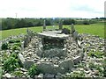
"In pasture, on gentle slope on N side of Leapford Stream; wedge tomb and possible megalithic tomb (9820, 9824) c. 350m to SW. Both stones are prostrate. East stone knocked c. 1976 and probable socket still visible at NW end; stone measures 3.1m by 0.85m by 0.4m. Second stone lies 1.35m to W; it measures 3.8m by 1.2m by 0.5m. Two boulders and some field stones lie on the site."
You may be viewing yesterday's version of this page. To see the most up to date information please register for a free account.
")
")
Do not use the above information on other web sites or publications without permission of the contributor.
Nearby Images from Geograph Britain and Ireland:
©2023(licence)
The above images may not be of the site on this page, they are loaded from Geograph.
Please Submit an Image of this site or go out and take one for us!
Click here to see more info for this site
Nearby sites
Click here to view sites on an interactive map of the areaKey: Red: member's photo, Blue: 3rd party photo, Yellow: other image, Green: no photo - please go there and take one, Grey: site destroyed
Download sites to:
KML (Google Earth)
GPX (GPS waypoints)
CSV (Garmin/Navman)
CSV (Excel)
To unlock full downloads you need to sign up as a Contributory Member. Otherwise downloads are limited to 50 sites.
Turn off the page maps and other distractions
Nearby sites listing. In the following links * = Image available
307m WSW 253° Island (Cork)* Wedge Tomb
407m NNE 28° Island Single Standing Stone* Standing Stone (Menhir)
2.2km WNW 299° Greenhill standing stone* Standing Stone (Menhir)
2.4km WNW 295° Greenhill South Ogham stone* Sculptured Stone
2.4km WSW 258° Lissard Stone Circle
2.4km WNW 296° Greenhill North Ogham stone* Sculptured Stone
2.5km WSW 250° Lissard Standing Stones
4.7km WNW 284° Reim Na Gaoithe Stone Circle (W560920)
5.7km SW 236° Knockantota North Standing Stones (W55818763)
5.8km SW 235° Knockantota North* Stone Circle (W55838758)
6.4km WSW 248° Kilquane Holed Stone* Holed Stone
7.7km SSW 209° Grenagh S Stone Circle
7.8km WSW 248° Lahakinneen standing stone* Standing Stone (Menhir)
8.8km SSE 168° Dromgarriff Stone Circle (W62338222)
9.4km SW 228° Pluckanes Stone Circle (W53548457)
9.4km SW 227° Pluckanes North Stone Row / Alignment (W536845)
9.7km SW 223° Pluckanes North standing stone* Standing Stone (Menhir)
9.9km W 259° Beennamweel East wedge tomb* Wedge Tomb
10.8km SSW 196° Newcastle Standing Stones* Standing Stones (W5752580425)
10.9km SW 231° Goats Hill anomalous stone group* Standing Stones
12.1km SSE 147° Ballyhesty Standing Stones
12.4km S 174° Ballygibbon* Standing Stones (W61757848)
12.5km WSW 253° Beenalaght* Stone Row / Alignment (W4852387309)
12.6km W 260° Glandine* Standing Stones (W481888)
12.6km SSE 160° Ballinvarrig Standing Stones (W648789)
View more nearby sites and additional images


 We would like to know more about this location. Please feel free to add a brief description and any relevant information in your own language.
 Wir möchten mehr über diese Stätte erfahren. Bitte zögern Sie nicht, eine kurze Beschreibung und relevante Informationen in Deutsch hinzuzufügen.
 Nous aimerions en savoir encore un peu sur les lieux. S'il vous plaît n'hesitez pas à ajouter une courte description et tous les renseignements pertinents dans votre propre langue.
 Quisieramos informarnos un poco más de las lugares. No dude en añadir una breve descripción y otros datos relevantes en su propio idioma.