
Recommended
More Related Content
What's hot
What's hot (20)
Similar to IMAGE INTERPRETATION TECHNIQUES of survey
Similar to IMAGE INTERPRETATION TECHNIQUES of survey (20)
More from Karan Patel
More from Karan Patel (20)
Recently uploaded
Recently uploaded (20)
IMAGE INTERPRETATION TECHNIQUES of survey
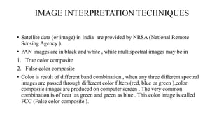
- 1. IMAGE INTERPRETATION TECHNIQUES • Satellite data (or image) in India are provided by NRSA (National Remote Sensing Agency ). • PAN images are in black and white , while multispectral images may be in 1. True color composite 2. False color composite • Color is result of different band combination , when any three different spectral images are passed through different color filters (red, blue or green ),color composite images are produced on computer screen . The very common combination is of near as green and green as blue . This color image is called FCC (False color composite ).
- 2. • Analog and digital images can be viewed on computer screen using software (image processors). Layers of images can be combined for better interpretation . For example monochrome images (PAN Panchromatic images ) having high special resolution can be combined with multispectral images having better spectral resolution, but poor in spatial resolution . The result of combining these images will produce a image having better spectral and spatial resolution . The image in false color by combining the images in three bands improved the interpretation ability . To extract meaningful information from images • Visual interpretation (human eyes ) • Digital interpretation (DN values classification ) both are applied .
- 3. • Humans are better skilled in visual interpretation but poor in spectral interpretation. While computers are poor (zero) in visual interpretation and better skilled in spectral interpretation . Hence ability of both humans and computers is used for image interpretation.
- 4. VISUAL INTERPRETATION • Fundamental photo characteristics are useful for visual interpretation of photograph and images. 1) SHAPE : • Shape of natural features like ponds , lakes , rivers , stream etc. is irregular. • While structural features or man made structures like buildings cultivated fields , roads canal , highway etc. Have regular geometrical shape • Linear object of irregular shoe with dark black color may be river or stream . • Straight linear feature having black color may be a canal .
- 5. 2) TONE AND COLOR : • Tone is whiteness or blackness of any color like pink is brightens tone of red color and maroon color has darker tone of red color. • Similarly in PAN images (black and white ) will have varying shades of grey, depending upon the energy reflected by the object. • Dry sand will appear white and wet sand will appear black and water content in sand will absorb more energy. • Water appear black as it will absorb more energy and hence reflectance will be less. Grey tone of black will vary with depth of water . Deep water will appear darker grey . Similarly grey tone vary with presence of total dissolved salts(TDS) and turbidity of water.
- 6. • Dry soil will have lighter grey tone while moist soils will have darker grey tone . This helps in identifying drainage network. • In multispectral images tone may vary in different bands. All types of vegetation have sane tone in blue band . But in near infrared band different vegetation have different color . In near infrared , vegetation appears in varying tones of red color . Red color tone variation foe vegetation depends on concentration of chlorophyll in leaves . Coniferous vegetation appears dark tone of red color. Variation in color is useful in interpretation.
- 7. TEXTURE :- • Texture is visual impression of smoothness or roughness of surface of object. Features having same spectral characteristic can be distinguished by variation in texture. • Smooth texture may be due to uniform surfaces, like road surface grassland, water, etc. rough texture may be due to uneven surface like forests. Hilly and mountainous terrain show rougher texture compared to plain areas. • Texture depends on altitude of sensor and scale of the image.
- 8. Pattern :- • Pattern is result of geometric shape or geometric arrangement of man made or natural features. • Pattern can be very useful tool to extract information. • In urban area road pattern will be used to distinguish residential, commercial and industrial zones. • Types of rocks or soil can be decided from drainage patterns. • Wind direction can be estimated from patterns of sand dune.
- 9. • Shadow :- Shadow and relief displacement are useful to view image in 3 dimension under stereoscope or in softwares for better interpretation and extraction of information. Displacement is distance between top and bottom of tall object in an image. Shadow of objects in image depends on :- I. Viewing angle of sensor II. Position of the sun at time exposure III. Size of the object
- 10. INTERPRETATION KEYS Interpretation keys are developed using elements of interpretation(size, shape, patterns, shadow, texture, tone, color, etc.) as well as altitude of orbit of satellite, orbital plan, time and season of exposure, etc. interpretation keys for some objects are as follows:- • Barren land :- I. Barrens land appears light grey. Sandy areas appear bright white. II. Sandy area is associated with seashores or desert.
- 11. • Wet land :- I. Wet lands located on periphery of water bodies appear dark grey. II. Floating vegetation on water body appear in red tone. III. Black tone for water. • Snow :- snow has high reflectance in visible length, hence appear bright but is having low reflectance for wavelength larger than 1.2µm hence appear darker. To differentiate snow and cloud, middle infrared image is used.
- 12. • Railway / road :- I. Rail lines have smooth curvature II. Roads have abrupt change in direction III. Concrete surface appear in light tone and asphalt road appear in dark tone. IV. Airport can be recognized by large area covered for hangers, terminal buildings and runways. • Urban-built up area :- I. Urban area is associated with road network with man made structures of regular geometry. II. Gardens or landscapes area appear in bright red color. III. Industrial area is associated with dumped raw materials, waste disposal area and many vehicles for transportation.
- 13. • Water :- I. Water appears dark grey to black shades. II. Deep water will be darker, than shallow water, as deep water absorb more energy. III. Turbid water will appear in light tone compared to clear water IV. Undistributed water will have smooth texture.
- 14. DIGITAL IMAGE PROCESSING • Humans are expert in visual interpretation but weak in spectral interpretation. But computers are expert in spectral interpretation, but zero in visual interpretation ability, hence for spectral interpretation ability of computers is used, which is known as digital interpretation. • Visual interpretation technique is time consuming process. And spectral reflectance property is not used in identifying objects. In visual interpretation human eye and brain applied having limitation in interpretation spectral values.(brightness values or digital numbers.) for classifying objects on basis of spectral pattern computers are used which is known as digital interpretation
- 15. • Digital image processing means manipulating digital number of pixels for better viewing of image or scene. Digital image process are as follows :- I. Radiometric and geometric correction, satellite images usually have some distortions due to platform effects, sensor effects, atmospheric effects. These distortions are reduced using computers to get accurate geometric representation of the earth surface features. This is known as image restoration. II. Band combination : computer software help in combining DN values of different spectral bands data of different satellites. Better spectral resolution of one satellite image may be combined with another satellite image having better spatial image, to improve the image quality.
- 16. DIGITAL INTERPRETATION • Each pixels is classified for different categories of object based on digital number. This classification is done by computers on the basis of value of each object available in computer. DN values of different object is different in spectral bands are measured in laboratory using radiometer and spectrometers. Classification of objected based on DN values is as follows : Supervised classification :- • Classification of objects is verified by field work by selecting training areas. • Objects in training areas are physically checked by going to training areas on ground. Geographical positioning system (GPS) is used to locate training areas. The information collected from training area are used for pixel classifications. This process is known as ground truth verification.
- 17. Unsupervised classification :- • Ground truth is not carried out. The classification is done only on basis of experimental DN values measured using radiometers and spectrometers.