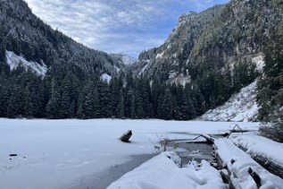
The Yurt is by far the most secluded of the four huts within the Mount Tahoma Trail System. A cozy studio in the wilderness surrounded by trees with access for a day hike to Griffin Mountain.
While hiking be cautious of logging trucks driving on the forest road. Usually they are done by 2:00 p.m., and an agreement between the Department of Natural Resources and the logging company provides the access to these amazing huts! The lower parking lot has a pit toilet facility for use before starting on your trek.
Start up the road to the Lower Yurt Trail, found after 0.88 miles of walking. Take a left and head into the dense forest, across a footbridge and through the quiet forest.
After 1.64 miles on the Lower Yurt Trail, stay right and continue for another 1.51 miles. Here you will come to the junction that allows access back up the hill to Snow Bowl and High Hut. Stay to the left and continue on the forest road for .82 miles. Here you will come to the trail for Griffin Mountain.
Take the road to the right for another .27 miles to the Yurt. Keep an eye out to the west and you will see Snow Bowl in the distance.
The Yurt can also be accessed by taking the forest roads up towards Snow Bowl. From the top saddle on the way to Snow Bowl, take the road to the left, and stay to the right for 2.42 miles to access the Yurt.
During your stay, consider the day hike to Griffin Mountain; it is 3.8 miles round trip from the Yurt and provides excellent views of Mount Rainier!
All huts have a wood stove, oven, stovetop, bunk beds/mattresses, outdoor pit toilet, and cooking utensils. Reservations must be obtained to stay overnight. There is also a tent pad outside if you want to rough it a bit.
 Trailhead