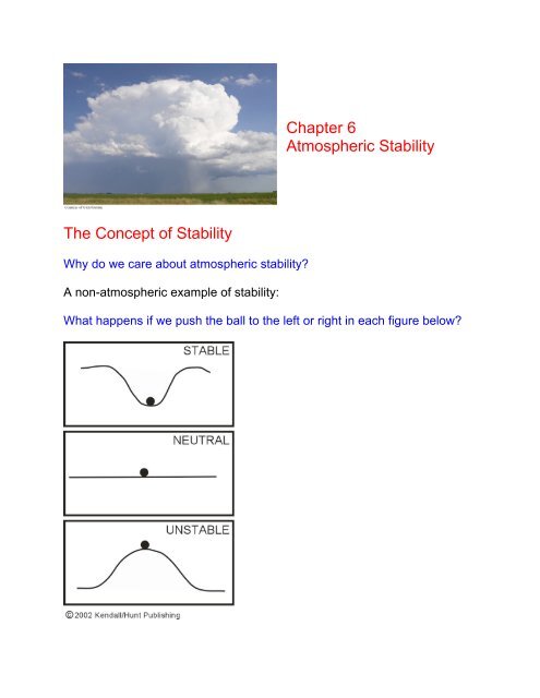
Chapter 6 Atmospheric Stability The Concept of Stability
Chapter 6 Atmospheric Stability The Concept of Stability
Chapter 6 Atmospheric Stability The Concept of Stability

Create successful ePaper yourself
Turn your PDF publications into a flip-book with our unique Google optimized e-Paper software.
<strong>Chapter</strong> 6<br />
<strong>Atmospheric</strong> <strong>Stability</strong><br />
<strong>The</strong> <strong>Concept</strong> <strong>of</strong> <strong>Stability</strong><br />
Why do we care about atmospheric stability<br />
A non-atmospheric example <strong>of</strong> stability:<br />
What happens if we push the ball to the left or right in each figure below
Air parcel - a distinct blob <strong>of</strong> air that we will imagine we can identify as it<br />
moves through the atmosphere<br />
Air parcels and stability:<br />
Stable: if the parcel is displaced vertically, it will return to its original<br />
position<br />
Neutral: if the parcel is displaced vertically, it will remain in its new position<br />
Unstable: if the parcel is displaced vertically, it will accelerate away from its<br />
original position in the direction <strong>of</strong> the initial displacement<br />
What happens to the size <strong>of</strong> an air parcel as it moves vertically in the<br />
atmosphere<br />
An air parcel will expand as it rises because it encounters lower pressure.<br />
An air parcel will compress as it sinks because it encounters higher<br />
pressure.
What happens to the temperature <strong>of</strong> an air parcel as it expands (rises) or<br />
compresses (sinks)<br />
<strong>The</strong> air parcel cools as it expands (rises).<br />
<strong>The</strong> air parcel warms as it compresses (sinks).<br />
Adiabatic process – a process in which an air parcel does not mix with its<br />
environment or exchange energy with its environment<br />
An air parcel will expand and cool as it rises and will compress and<br />
warm as it sinks.<br />
Lapse Rates<br />
Dry adiabatic lapse rate – the rate at which an unsaturated air parcel will<br />
cool if it rises or warm as it sinks (applies to an air parcel with a relative<br />
humidity <strong>of</strong> less than 100%)<br />
Dry adiabatic lapse rate = 10 deg C / km<br />
Moist adiabatic lapse rate – the rate at which a saturated air parcel will cool<br />
if it rises or warm if it sinks (applies to an air parcel with a relative humidity<br />
<strong>of</strong> 100%)<br />
Moist adiabatic lapse rate = 6 deg C / km (on average in the troposphere)<br />
Why is the moist adiabatic lapse rate different Why is it less than the dry<br />
adiabatic lapse rate<br />
What happens to a saturated air parcel as it rises<br />
1. <strong>The</strong> air parcel will cool as it rises<br />
2. Water vapor will condense as the parcel rises (a cloud forms)<br />
3. As water vapor condenses latent heat is released<br />
4. <strong>The</strong> latent heat that is released will <strong>of</strong>fset some <strong>of</strong> the cooling that<br />
occurred as the air parcel rose (the amount <strong>of</strong> latent heat released<br />
will vary, but on average will <strong>of</strong>fset about 4 deg C / km <strong>of</strong> cooling)<br />
Use the dry adiabatic lapse rate or moist adiabatic lapse rate to determine<br />
the temperature <strong>of</strong> an air parcel as it rises or sinks in the atmosphere.
Environment – the atmosphere outside <strong>of</strong> an air parcel<br />
Environmental lapse rate – the rate at which the environment’s temperature<br />
decreases with increasing altitude<br />
Use the environmental lapse rate to determine the temperature <strong>of</strong> the<br />
environment as you move up or down in the atmosphere.<br />
Idealized environmental temperature<br />
pr<strong>of</strong>ile<br />
How do we measure the<br />
environmental temperature pr<strong>of</strong>ile<br />
Is the environmental temperature<br />
pr<strong>of</strong>ile always the same<br />
Inversion layer – a layer <strong>of</strong> the<br />
atmosphere where the<br />
environmental temperature<br />
increases with increasing altitude<br />
What does a negative environmental<br />
lapse rate mean<br />
Determining <strong>Stability</strong><br />
To determine stability we need to compare the temperature <strong>of</strong> an air parcel<br />
to the temperature <strong>of</strong> its environment.<br />
If an air parcel is warmer than its environment it will rise.<br />
If an air parcel is colder than its environment it will sink.
Two sample environmental temperature pr<strong>of</strong>iles:<br />
Examples <strong>of</strong> determining stability:<br />
For these examples<br />
an air parcel starts<br />
at the surface, and<br />
has the same<br />
temperature as the<br />
environment at the<br />
surface.<br />
<strong>The</strong> air parcel is<br />
then lifted 1 km.<br />
How does the<br />
temperature <strong>of</strong> the<br />
air parcel change<br />
as it is lifted<br />
What is the stability<br />
<strong>of</strong> the air parcel in<br />
each panel <strong>of</strong> this<br />
figure
Conditionally unstable – the condition required for instability is that the<br />
displaced air parcel is saturated.<br />
An example <strong>of</strong> a conditionally unstable atmospheric layer:<br />
Summary <strong>of</strong> Categories <strong>of</strong> <strong>Atmospheric</strong> Layer <strong>Stability</strong><br />
Environmental Lapse Rate (ELR) <strong>Stability</strong><br />
ELR > 10 deg C / km<br />
Unstable<br />
ELR = 10 deg C / km<br />
Neutral if unsaturated<br />
Unstable if saturated<br />
6 deg C / km < ELR < 10 deg C / km Conditionally unstable (see above)<br />
ELR = 6 deg C / km<br />
Neutral if saturated<br />
Stable if unsaturated<br />
ELR < 6 deg C<br />
Stable
<strong>The</strong> environmental<br />
temperature pr<strong>of</strong>ile is<br />
<strong>of</strong>ten more complex<br />
than was shown in the<br />
examples above. On<br />
the left are two<br />
examples <strong>of</strong> actual<br />
environmental<br />
temperature pr<strong>of</strong>iles<br />
and the temperature<br />
<strong>of</strong> an air parcel as it<br />
rises through the<br />
environment.<br />
What is the stability <strong>of</strong><br />
the air parcel as it<br />
rises through the<br />
environmental<br />
temperature pr<strong>of</strong>ile<br />
Does the stability<br />
change if we look at<br />
different levels <strong>of</strong> the<br />
atmosphere
How can the stability <strong>of</strong> an atmospheric layer be changed<br />
What happens to the stability <strong>of</strong> the lower part <strong>of</strong> the atmosphere over the<br />
course <strong>of</strong> a day<br />
<strong>Stability</strong> and thunderstorm development<br />
Convection – an air parcel rising buoyantly because it is warmer than its<br />
environment<br />
What happens to an<br />
unsaturated air parcel<br />
as it is lifted<br />
Size<br />
Temperature<br />
Relative humidity<br />
What happens when<br />
the relative humidity <strong>of</strong><br />
the air parcel increases<br />
to 100%<br />
Lifting condensation level – the level where condensation first occurs as an<br />
air parcel is lifted (where the relative humidity <strong>of</strong> the air parcel becomes<br />
100%)<br />
Level <strong>of</strong> free convection – the level where an air parcel first becomes<br />
buoyant (warmer than its environment)
Lifting Mechanisms<br />
How are air parcels lifted in the atmosphere
Clouds<br />
How do clouds form<br />
(In class experiment to make a cloud)<br />
Ingredients for a cloud:<br />
1.<br />
2.<br />
How is the 2 nd ingredient achieved in the atmosphere<br />
3.<br />
Do we need a 3 rd ingredient Why<br />
What serves as the 3 rd ingredient<br />
Clouds form when an air parcel is lifted to the lifting condensation<br />
level and condensation occurs<br />
<strong>The</strong>re are four basic types <strong>of</strong> clouds based on Latin words:<br />
Stratus: “spread out”<br />
layered cloud<br />
Cumulus: “heap”<br />
puffy (cotton ball) cloud<br />
Cirrus: “curl <strong>of</strong> hair”<br />
wispy cloud<br />
Nimbus: “rain cloud” or “rain storm”<br />
raining cloud
Cloud categories:<br />
<strong>The</strong>re are also four categories based on:<br />
Height/altitude, vertical development, and appearance <strong>of</strong> the cloud<br />
<br />
Low (0-2 km): no special prefix for height<br />
stratus, stratocumulus, nimbostratus<br />
Middle (2-6 km): alto-----<br />
altostratus, altocumulus<br />
High (>6 km): cirrus or cirro-----<br />
cirrus, cirrostratus, cirrocumulus<br />
Vertically developed: cumulus or cumulo----<br />
cumulus, cumulonimbus<br />
Cumuliform clouds occur more in unstable environments when the air<br />
parcels undergo a lot <strong>of</strong> vertical motion<br />
Stratiform clouds occur in more stable environments