

St Martins Marsh Aquatic Preserve
16gt4Qnop
16gt4Qnop

You also want an ePaper? Increase the reach of your titles
YUMPU automatically turns print PDFs into web optimized ePapers that Google loves.
<strong>St</strong>. <strong>Martins</strong> <strong>Marsh</strong><br />
<strong>Aquatic</strong> <strong>Preserve</strong><br />
Management Plan<br />
<strong>St</strong>. <strong>Martins</strong> <strong>Marsh</strong> <strong>Aquatic</strong> <strong>Preserve</strong><br />
3266 North Sailboat Avenue<br />
Crystal River, FL 34428<br />
352.228.6028 • www.dep.state.fl.us/coastal/sites/stmartins<br />
Florida Department of Environmental Protection<br />
Florida Coastal Office<br />
3900 Commonwealth Blvd., MS #235,<br />
Tallahassee, FL 32399 • www.aquaticpreserves.org
This publication funded in part through<br />
a grant agreement from the Florida<br />
Department of Environmental Protection,<br />
Florida Coastal Management Program by<br />
a grant provided by the Office of Ocean<br />
and Coastal Resource Management<br />
under the Coastal Zone Management Act<br />
of 1972, as amended, National Oceanic<br />
and Atmospheric Administration Award<br />
No. NA12NOS4190093-CM327 and<br />
NA15NOS4190096-CM06M. The views,<br />
statements, finding, conclusions, and<br />
recommendations expressed herein<br />
are those of the author(s) and do not<br />
necessarily reflect the views of the <strong>St</strong>ate of<br />
Florida, National Oceanic and Atmospheric<br />
Administration, or any of its sub-agencies.<br />
December 2016<br />
Right: Nurse shark swimming through a<br />
seagrass meadow off the <strong>St</strong>. <strong>Martins</strong> Keys.<br />
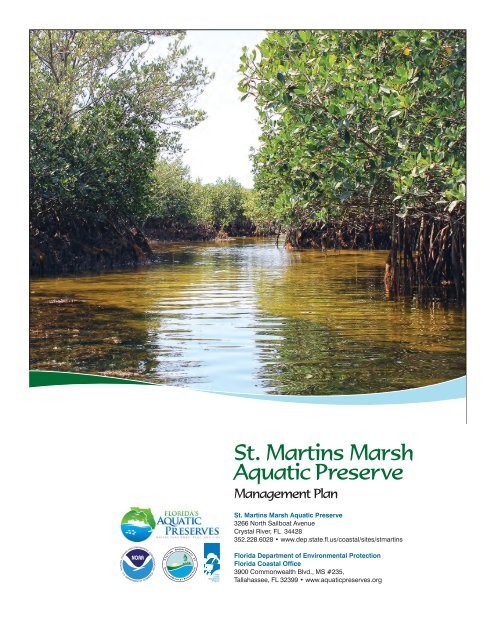
Cover photo: Tidal creek winding<br />
through red mangroves at low tide.<br />
<strong>St</strong>. <strong>Martins</strong> <strong>Marsh</strong><br />
<strong>Aquatic</strong> <strong>Preserve</strong><br />
Management Plan<br />
<strong>St</strong>. <strong>Martins</strong> <strong>Marsh</strong> <strong>Aquatic</strong> <strong>Preserve</strong><br />
3266 North Sailboat Avenue<br />
Crystal River, FL 34428<br />
352.228.6028 • www.dep.state.fl.us/coastal/sites/stmartins<br />
Florida Department of Environmental Protection<br />
Florida Coastal Office<br />
3900 Commonwealth Blvd., MS #235,<br />
Tallahassee, FL 32399 • www.aquaticpreserves.org
Limestone crevice in the exposed bedrock of <strong>St</strong>. <strong>Martins</strong> <strong>Marsh</strong> <strong>Aquatic</strong> <strong>Preserve</strong>.<br />
Mission <strong>St</strong>atement<br />
The Florida Coastal Office’s mission statement is: Conserving and restoring Florida’s coastal and<br />
aquatic resources for the benefit of people and the environment.<br />
The four long-term goals of the Florida Coastal Office’s <strong>Aquatic</strong> <strong>Preserve</strong> Program are to:<br />
1. protect and enhance the ecological integrity of the aquatic preserves;<br />
2. restore areas to their natural condition;<br />
3. encourage sustainable use and foster active stewardship by engaging local communities in the<br />
protection of aquatic preserves; and<br />
4. improve management effectiveness through a process based on sound science, consistent<br />
evaluation, and continual reassessment.
Acquisition and Restoration Council Management Plan Compliance Checklist<br />
Land Management Plan Compliance Checklist<br />
Required for <strong>St</strong>ate-owned conservation lands over 160 acres<br />
Item # Requirement <strong>St</strong>atute/Rule Pg#/App<br />
Section A: Acquisition Information Items<br />
1 The common name of the property. 18-2.018 &<br />
18-2.021<br />
2 The land acquisition program, if any, under which the property<br />
was acquired.<br />
3 Degree of title interest held by the Board, including reservations<br />
and encumbrances such as leases.<br />
18-2.018 &<br />
18-2.021<br />
4 The legal description and acreage of the property. 18-2.018 &<br />
18-2.021<br />
5 A map showing the approximate location and boundaries of the property,<br />
and the location of any structures or improvements to the property.<br />
6 An assessment as to whether the property, or any portion, should be<br />
declared surplus. Provide Information regarding assessment and<br />
analysis in the plan, and provide corresponding map.<br />
7 Identification of other parcels of land within or immediately adjacent to<br />
the property that should be purchased because they are essential to<br />
management of the property. Please clearly indicate parcels on a map.<br />
8 Identification of adjacent land uses that conflict with the planned use<br />
of the property, if any.<br />
9 A statement of the purpose for which the lands were acquired, the<br />
projected use or uses as defined in 253.034 and the statutory authority<br />
for such use or uses.<br />
10 Proximity of property to other significant <strong>St</strong>ate, local or federal land<br />
or water resources.<br />
Ex. Sum.<br />
p. 1<br />
18-2.021 p. 1, 6-8<br />
18-2.018 &<br />
18-2.021<br />
Ex. Sum<br />
& p. 12<br />
p. 11<br />
18-2.021 N/A<br />
18-2.021 N/A<br />
18-2.021 p. 43-45<br />
259.032(10) p. 6<br />
18-2.021 p. 41-43<br />
Section B: Use Items<br />
11 The designated single use or multiple use management for the property,<br />
including use by other managing entities.<br />
12 A description of past and existing uses, including any unauthorized<br />
uses of the property.<br />
13 A description of alternative or multiple uses of the property considered by<br />
the lessee and a statement detailing why such uses were not adopted.<br />
14 A description of the management responsibilities of each entity involved<br />
in the property’s management and how such responsibilities will<br />
be coordinated.<br />
15 Include a provision that requires that the managing agency consult with the<br />
Division of Historical Resources, Department of <strong>St</strong>ate before taking actions<br />
that may adversely affect archeological or historical resources.<br />
16 Analysis/description of other managing agencies and private land managers,<br />
if any, which could facilitate the restoration or management of the land.<br />
17 A determination of the public uses and public access that would be<br />
consistent with the purposes for which the lands were acquired.<br />
18 A finding regarding whether each planned use complies with the 1981<br />
<strong>St</strong>ate Lands Management Plan, particularly whether such uses represent<br />
“balanced public utilization,” specific agency statutory authority and<br />
any other legislative or executive directives that constrain the use<br />
of such property.<br />
19 Letter of compliance from the local government stating that the LMP is<br />
in compliance with the Local Government Comprehensive Plan.<br />
18-2.018 &<br />
18-2.021<br />
18-2.018 &<br />
18-2.021<br />
p. 10<br />
18-2.018 N/A<br />
p. 9-10, 37-<br />
38, 43-45,<br />
70-71<br />
18-2.018 p. 6-8, 47-73<br />
18-2.021 App. E.2<br />
18-2.021 p. 41-43, 51-<br />
58, 61-64<br />
259.032(10) p. 69-73<br />
18-2.021 p. 6-8<br />
BOT requirement<br />
App. E.3
Land Management Plan Compliance Checklist<br />
Required for <strong>St</strong>ate-owned conservation lands over 160 acres<br />
Item # Requirement <strong>St</strong>atute/Rule Pg#/App<br />
20 An assessment of the impact of planned uses on the renewable and<br />
non-renewable resources of the property, including soil and water<br />
resources, and a detailed description of the specific actions that will<br />
be taken to protect, enhance and conserve these resources and to<br />
compensate/mitigate damage caused by such uses, including a<br />
description of how the manager plans to control and prevent soil<br />
erosion and soil or water contamination.<br />
18-2.018 &<br />
18-2.021<br />
P. 12-22,<br />
47-73<br />
21 *For managed areas larger than 1,000 acres, an analysis of the<br />
multiple-use potential of the property which shall include the potential<br />
of the property to generate revenues to enhance the management of<br />
the property provided that no lease, easement, or license for such<br />
revenue-generating use shall be entered into if the granting of such<br />
lease, easement or license would adversely affect the tax exemption<br />
of the interest on any revenue bonds issued to fund the acquisition of<br />
the affected lands from gross income for federal income tax purposes,<br />
pursuant to Internal Revenue Service regulations.<br />
18-2.021 &<br />
253.036<br />
N/A<br />
22 If the lead managing agency determines that timber resource<br />
management is not in conflict with the primary management objectives<br />
of the managed area, a component or section, prepared by a qualified<br />
professional forester, that assesses the feasibility of managing timber<br />
resources pursuant to section 253.036, F.S.<br />
18-021 N/A<br />
23 A statement regarding incompatible use in reference to Ch. 253.034(10). 253.034(10) p. 71<br />
*The following taken from 253.034(10) is not a land management plan requirement; however, it should be considered<br />
when developing a land management plan: The following additional uses of conservation lands acquired pursuant to<br />
the Florida Forever program and other state-funded conservation land purchase programs shall be authorized, upon<br />
a finding by the Board of Trustees, if they meet the criteria specified in paragraphs (a)-(e): water resource development<br />
projects, water supply development projects, storm-water management projects, linear facilities and sustainable<br />
agriculture and forestry. Such additional uses are authorized where: (a) Not inconsistent with the management plan<br />
for such lands; (b) Compatible with the natural ecosystem and resource values of such lands; (c) The proposed use is<br />
appropriately located on such lands and where due consideration is given to the use of other available lands; (d) The<br />
using entity reasonably compensates the titleholder for such use based upon an appropriate measure of value; and<br />
(e) The use is consistent with the public interest.<br />
Section C: Public Involvement Items<br />
24 A statement concerning the extent of public involvement and local<br />
government participation in the development of the plan, if any.<br />
25 The management prospectus required pursuant to paragraph<br />
(9)(d) shall be available to the public for a period of 30 days prior to<br />
the public hearing.<br />
26 LMPs and LMP updates for parcels over 160 acres shall be developed<br />
with input from an advisory group who must conduct at least one public<br />
hearing within the county in which the parcel or project is located. Include<br />
the advisory group members and their affiliations, as well as the<br />
date and location of the advisory group meeting.<br />
27 Summary of comments and concerns expressed by the advisory group<br />
for parcels over 160 acres<br />
18-2.021 App. C<br />
259.032(10) N/A<br />
259.032(10) App. C<br />
18-2.021 App. C<br />
28 During plan development, at least one public hearing shall be held in<br />
each affected county. Notice of such public hearing shall be posted on<br />
the parcel or project designated for management, advertised in a paper<br />
of general circulation, and announced at a scheduled meeting of the local<br />
governing body before the actual public hearing. Include a copy of each<br />
County’s advertisements and announcements (meeting minutes will<br />
suffice to indicate an announcement) in the management plan.<br />
253.034(5) &<br />
259.032(10)<br />
App. C<br />
29 The manager shall consider the findings and recommendations of the<br />
land management review team in finalizing the required 10-year update<br />
of its management plan. Include managers replies to the teams findings<br />
and recommendations.<br />
259.036 N/A
Land Management Plan Compliance Checklist<br />
Required for <strong>St</strong>ate-owned conservation lands over 160 acres<br />
Item # Requirement <strong>St</strong>atute/Rule Pg#/App<br />
30 Summary of comments and concerns expressed by the management<br />
review team, if required by Section 259.036, F.S.<br />
18-2.021 N/A<br />
31 If manager is not in agreement with the management review team’s<br />
findings and recommendations in finalizing the required 10-year update<br />
of its management plan, the managing agency should explain why<br />
they disagree with the findings or recommendations.<br />
259.036 N/A<br />
Section D: Natural Resources<br />
32 Location and description of known and reasonably identifiable renewable<br />
and non-renewable resources of the property regarding soil types. Use<br />
brief descriptions and include USDA maps when available.<br />
18-2.021 p. 16-18<br />
33 Insert FNAI based natural community maps when available. ARC consensus<br />
p. 24<br />
34 Location and description of known and reasonably identifiable<br />
renewable and non-renewable resources of the property regarding<br />
outstanding native landscapes containing relatively unaltered flora,<br />
fauna and geological conditions.<br />
18-2.021 Ex Sum<br />
35 Location and description of known and reasonably identifiable renewable<br />
and non-renewable resources of the property regarding unique natural<br />
features and/or resources including but not limited to virgin timber stands,<br />
scenic vistas, natural rivers and streams, coral reefs, natural springs,<br />
caverns and large sinkholes.<br />
18-2.018 &<br />
18-2.021<br />
p. 23-33<br />
36 Location and description of known and reasonably identifiable<br />
renewable and non-renewable resources of the property regarding<br />
beaches and dunes.<br />
18-2.021 p. 28<br />
37 Location and description of known and reasonably identifiable renewable<br />
and non-renewable resources of the property regarding mineral resources,<br />
such as oil, gas and phosphate, etc.<br />
38 Location and description of known and reasonably identifiable renewable<br />
and non-renewable resources of the property regarding fish and wildlife,<br />
both game and non-game, and their habitat.<br />
18-2.018 &<br />
18-2.021<br />
18-2.018 &<br />
18-2.021<br />
p. 16<br />
p. 23-37,<br />
App. B.4<br />
39 Location and description of known and reasonably identifiable renewable<br />
and non-renewable resources of the property regarding <strong>St</strong>ate and Federally<br />
listed endangered or threatened species and their habitat.<br />
40 The identification or resources on the property that are listed in the Natural<br />
Areas Inventory. Include letter from FNAI or consultant where appropriate.<br />
41 Specific description of how the managing agency plans to identify, locate,<br />
protect and preserve or otherwise use fragile, nonrenewable natural and<br />
cultural resources.<br />
18-2.021 p. 23-35,<br />
App. B.4<br />
18-2.021 p. 23-33<br />
259.032(10) p. 37-38, 47-<br />
73, App. E.2<br />
42 Habitat Restoration and Improvement 259.032(10)<br />
& 253.034(5)<br />
42-A.<br />
Describe management needs, problems and a desired outcome and<br />
the key management activities necessary to achieve the enhancement,<br />
protection and preservation of restored habitats and enhance the natural,<br />
historical and archeological resources and their values for which the lands<br />
were acquired.<br />
259.032(10)<br />
& 253.034(5)<br />
p. 23-33, 37-<br />
38, 47-73<br />
42-B.<br />
Provide a detailed description of both short (2-year planning period) and<br />
long-term (10-year planning period) management goals, and a priority<br />
schedule based on the purposes for which the lands were acquired and<br />
include a timeline for completion.<br />
259.032(10)<br />
& 253.034(5)<br />
App. D.1<br />
42-C. The associated measurable objectives to achieve the goals. 259.032(10)<br />
& 253.034(5)<br />
App. D.1
Land Management Plan Compliance Checklist<br />
Required for <strong>St</strong>ate-owned conservation lands over 160 acres<br />
Item # Requirement <strong>St</strong>atute/Rule Pg#/App<br />
42-D.<br />
The related activities that are to be performed to meet the land<br />
management objectives and their associated measures. Include fire<br />
management plans - they can be in plan body or an appendix.<br />
259.032(10)<br />
& 253.034(5)<br />
App. D.1<br />
42-E.<br />
A detailed expense and manpower budget in order to provide a<br />
management tool that facilitates development of performance measures,<br />
including recommendations for cost-effective methods of accomplishing<br />
those activities.<br />
259.032(10)<br />
& 253.034(5)<br />
App. D.1<br />
43 ***Quantitative data description of the land regarding an inventory of<br />
forest and other natural resources and associated acreage. See footnote.<br />
44 Sustainable Forest Management, including implementation of prescribed<br />
fire management<br />
253.034(5) Ex Sum<br />
18-2.021,<br />
253.034(5) &<br />
259.032(10)<br />
44-A.<br />
Management needs, problems and a desired outcome<br />
(see requirement for # 42-A).<br />
18-2.021,<br />
253.034(5) &<br />
259.032(10)<br />
N/A<br />
44-B.<br />
Detailed description of both short and long-term management goals<br />
(see requirement for # 42-B).<br />
18-2.021,<br />
253.034(5) &<br />
259.032(10)<br />
N/A<br />
44-C. Measurable objectives (see requirement for #42-C). 18-2.021,<br />
253.034(5) &<br />
259.032(10)<br />
44-D. Related activities (see requirement for #42-D). 18-2.021,<br />
253.034(5) &<br />
259.032(10)<br />
44-E. Budgets (see requirement for #42-E). 18-2.021,<br />
253.034(5) &<br />
259.032(10)<br />
N/A<br />
N/A<br />
N/A<br />
45 Imperiled species, habitat maintenance, enhancement, restoration<br />
or population restoration<br />
259.032(10)<br />
& 253.034(5)<br />
45-A.<br />
Management needs, problems and a desired outcome<br />
(see requirement for # 42-A).<br />
259.032(10)<br />
& 253.034(5)<br />
p. 23-37,<br />
47-73<br />
45-B.<br />
Detailed description of both short and long-term management goals<br />
(see requirement for # 42-B).<br />
259.032(10)<br />
& 253.034(5)<br />
App. D.1<br />
45-C. Measurable objectives (see requirement for #42-C). 259.032(10)<br />
& 253.034(5)<br />
45-D. Related activities (see requirement for #42-D). 259.032(10)<br />
& 253.034(5)<br />
45-E. Budgets (see requirement for #42-E). 259.032(10)<br />
& 253.034(5)<br />
App. D.1<br />
App. D.1<br />
App. D.1<br />
46 ***Quantitative data description of the land regarding an inventory of<br />
exotic and invasive plants and associated acreage. See footnote.<br />
253.034(5) App. B.3.4<br />
47 Place the Arthropod Control Plan in an appendix. If one does not exist,<br />
provide a statement as to what arrangement exists between the local<br />
mosquito control district and the management unit.<br />
BOT requirement<br />
via lease<br />
language<br />
App. B.4<br />
48 Exotic and invasive species maintenance and control 259.032(10)<br />
& 253.034(5)<br />
48-A.<br />
Management needs, problems and a desired outcome<br />
(see requirement for # 42-A).<br />
259.032(10)<br />
& 253.034(5)<br />
p. 35-37, 63<br />
48-B.<br />
Detailed description of both short and long-term management goals<br />
(see requirement for # 42-B).<br />
259.032(10)<br />
& 253.034(5)<br />
App. D.1
Land Management Plan Compliance Checklist<br />
Required for <strong>St</strong>ate-owned conservation lands over 160 acres<br />
Item # Requirement <strong>St</strong>atute/Rule Pg#/App<br />
48-C. Measurable objectives (see requirement for #42-C). 259.032(10)<br />
& 253.034(5)<br />
48-D. Related activities (see requirement for #42-D). 259.032(10)<br />
& 253.034(5)<br />
48-E. Budgets (see requirement for #42-E). 259.032(10)<br />
& 253.034(5)<br />
Section E: Water Resources<br />
53-A.<br />
53-B.<br />
49 A statement as to whether the property is within and/or adjacent to an<br />
aquatic preserve or a designated area of critical state concern or an area<br />
under study for such designation. If yes, provide a list of the appropriate<br />
managing agencies that have been notified of the proposed plan.<br />
50 Location and description of known and reasonably identifiable renewable and<br />
non-renewable resources of the property regarding water resources,<br />
including water classification for each water body and the identification of any<br />
such water body that is designated as an Outstanding Florida Water under Rule<br />
62-302.700, F.A.C.<br />
51 Location and description of known and reasonably identifiable<br />
renewable and non-renewable resources of the property regarding<br />
swamps, marshes and other wetlands.<br />
52 ***Quantitative description of the land regarding an inventory of<br />
hydrological features and associated acreage. See footnote.<br />
18-2.018 &<br />
18-2.021<br />
App. D.1<br />
App. D.1<br />
App. D.1<br />
p. 1-4<br />
18-2.021 p. 1-4, 18-22<br />
18-2.021 p. 24-27<br />
253.034(5) Ex. Sum<br />
53 Hydrological Preservation and Restoration 259.032(10)<br />
& 253.034(5)<br />
Management needs, problems and a desired outcome<br />
(see requirement for # 42-A).<br />
Detailed description of both short and long-term management goals<br />
(see requirement for # 42-B).<br />
259.032(10)<br />
& 253.034(5)<br />
259.032(10)<br />
& 253.034(5)<br />
53-C. Measurable objectives (see requirement for #42-C). 259.032(10)<br />
& 253.034(5)<br />
53-D. Related activities (see requirement for #42-D). 259.032(10)<br />
& 253.034(5)<br />
53-E. Budgets (see requirement for #42-E). 259.032(10)<br />
& 253.034(5)<br />
App. D.1<br />
App. D.1<br />
App. D.1<br />
App. D.1<br />
App. D.1<br />
Section F: Historical, Archaeological and Cultural Resources<br />
54 **Location and description of known and reasonably identifiable<br />
renewable and non-renewable resources of the property regarding<br />
archeological and historical resources. Include maps of all cultural<br />
resources except Native American sites, unless such sites are major<br />
points of interest that are open to public visitation.<br />
18-2.018,<br />
18-2.021 &<br />
per DHR’s<br />
request<br />
Ex. Sum, p.<br />
37-38, App<br />
B.5<br />
57-A.<br />
57-B.<br />
55 ***Quantitative data description of the land regarding an inventory<br />
of significant land, cultural or historical features and associated acreage.<br />
56 A description of actions the agency plans to take to locate and<br />
identify unknown resources such as surveys of unknown archeological<br />
and historical resources.<br />
253.034(5) Ex. Sum, p.<br />
37-38, App<br />
B.5<br />
18-2.021 App. D.1<br />
57 Cultural and Historical Resources 259.032(10)<br />
& 253.034(5)<br />
Management needs, problems and a desired outcome (see requirement for<br />
# 42-A).<br />
Detailed description of both short and long-term management goals (see<br />
requirement for # 42-B).<br />
259.032(10)<br />
& 253.034(5)<br />
259.032(10)<br />
& 253.034(5)<br />
App. D.1<br />
App. D.1
Land Management Plan Compliance Checklist<br />
Required for <strong>St</strong>ate-owned conservation lands over 160 acres<br />
Item # Requirement <strong>St</strong>atute/Rule Pg#/App<br />
57-C. Measurable objectives (see requirement for #42-C). 259.032(10)<br />
& 253.034(5)<br />
App. D.1<br />
57-D. Related activities (see requirement for #42-D). 259.032(10)<br />
& 253.034(5)<br />
57-E. Budgets (see requirement for #42-E). 259.032(10)<br />
& 253.034(5)<br />
App. D.1<br />
App. D.1<br />
**While maps of Native American sites should not be included in the body of the management plan, the DSL<br />
urges each managing agency to provide such information to the Division of Historical Resources for inclusion in<br />
their proprietary database. This information should be available for access to new managers to assist them in<br />
developing, implementing and coordinating their management activities.<br />
Section G: Facilities (Infrastructure, Access, Recreation)<br />
58 ***Quantitative data description of the land regarding an inventory of infrastructure<br />
and associated acreage. See footnote.<br />
253.034(5) p. 77-78<br />
59 Capital Facilities and Infrastructure 259.032(10)<br />
& 253.034(5)<br />
59-A.<br />
Management needs, problems and a desired outcome (see requirement for<br />
# 42-A).<br />
259.032(10)<br />
& 253.034(5)<br />
p. 75-78,<br />
App. D.1<br />
59-B.<br />
Detailed description of both short and long-term management goals (see<br />
requirement for # 42-B).<br />
259.032(10)<br />
& 253.034(5)<br />
App. D.1<br />
59-C. Measurable objectives (see requirement for #42-C). 259.032(10)<br />
& 253.034(5)<br />
59-D. Related activities (see requirement for #42-D). 259.032(10)<br />
& 253.034(5)<br />
59-E. Budgets (see requirement for #42-E). 259.032(10)<br />
& 253.034(5)<br />
App. D.1<br />
App. D.1<br />
App. D.1<br />
60 *** Quantitative data description of the land regarding an inventory of recreational<br />
facilities and associated acreage.<br />
253.034(5) p. 69-71,<br />
App. D.1<br />
61 Public Access and Recreational Opportunities 259.032(10)<br />
& 253.034(5)<br />
61-A.<br />
Management needs, problems and a desired outcome (see requirement for<br />
# 42-A).<br />
259.032(10)<br />
& 253.034(5)<br />
App. D.1<br />
61-B.<br />
Detailed description of both short and long-term management goals (see<br />
requirement for # 42-B).<br />
259.032(10)<br />
& 253.034(5)<br />
App. D.1<br />
61-C. Measurable objectives (see requirement for #42-C). 259.032(10)<br />
& 253.034(5)<br />
61-D. Related activities (see requirement for #42-D). 259.032(10)<br />
& 253.034(5)<br />
61-E. Budgets (see requirement for #42-E). 259.032(10)<br />
& 253.034(5)<br />
App. D.1<br />
App. D.1<br />
App. D.1<br />
Section H: Other/ Managing Agency Tools<br />
62 Place this LMP Compliance Checklist at the front of the plan. ARC and<br />
managing<br />
agency consensus<br />
Front & App.<br />
E.1<br />
63 Place the Executive Summary at the front of the LMP. Include a physical<br />
description of the land.<br />
ARC and<br />
253.034(5)<br />
Ex. Sum
Land Management Plan Compliance Checklist<br />
Required for <strong>St</strong>ate-owned conservation lands over 160 acres<br />
Item # Requirement <strong>St</strong>atute/Rule Pg#/App<br />
64 If this LMP is a 10-year update, note the accomplishments since the drafting<br />
of the last LMP set forth in an organized (categories or bullets) format.<br />
65 Key management activities necessary to achieve the desired outcomes<br />
regarding other appropriate resource management.<br />
66 Summary budget for the scheduled land management activities of the LMP<br />
including any potential fees anticipated from public or private entities for projects<br />
to offset adverse impacts to imperiled species or such habitat, which fees<br />
shall be used to restore, manage, enhance, repopulate, or acquire imperiled<br />
species habitat for lands that have or are anticipated to have imperiled species<br />
or such habitat onsite. The summary budget shall be prepared in such a<br />
manner that it facilitates computing an aggregate of land management costs<br />
for all state-managed lands using the categories described in s. 259.037(3)<br />
which are resource management, administration, support, capital improvements,<br />
recreation visitor services, law enforcement activities.<br />
67 Cost estimate for conducting other management activities which would<br />
enhance the natural resource value or public recreation value for which the<br />
lands were acquired, include recommendations for cost-effective methods<br />
in accomplishing those activities.<br />
ARC consensus<br />
App. D.3<br />
259.032(10) p. 47-73<br />
253.034(5) App. D.1<br />
259.032(10) App. D.1<br />
68 A statement of gross income generated, net income and expenses. 18-2.018 N/A<br />
*** = The referenced inventories shall be of such detail that objective measures and benchmarks can be established<br />
for each tract of land and monitored during the lifetime of the plan. All quantitative data collected shall<br />
be aggregated, standardized, collected, and presented in an electronic format to allow for uniform management<br />
reporting and analysis. The information collected by the DEP pursuant to s. 253.0325(2) shall be available to the<br />
land manager and his or her assignee.
Executive Summary<br />
<strong>St</strong>. <strong>Martins</strong> <strong>Marsh</strong> <strong>Aquatic</strong> <strong>Preserve</strong> Management Plan<br />
Lead Agency<br />
Common Name of Property<br />
Location<br />
Florida Department of Environmental Protection’s (DEP) Florida Coastal Office (FCO)<br />
<strong>St</strong>. <strong>Martins</strong> <strong>Marsh</strong> <strong>Aquatic</strong> <strong>Preserve</strong> (SMMAP)<br />
Citrus County, Florida<br />
Acreage Total: 28,461<br />
Acreage Breakdown According to Florida Natural Areas Inventory (FNAI) Natural Community Type<br />
FNAI Natural Communities<br />
Acreage according to GIS<br />
Hydric Hammock 1,518<br />
Shell Mounds<br />
Unknown<br />
Mangrove Swamp 1,607<br />
Salt <strong>Marsh</strong> 4,677<br />
Consolidated Substrate<br />
Unconsolidated Substrate<br />
Unknown<br />
Unknown<br />
Mollusk Reef 49<br />
Octocoral Bed<br />
Sponge Bed<br />
Algal Bed<br />
Unknown<br />
Unknown<br />
Unknown<br />
Seagrass Bed 17,705<br />
<strong>Aquatic</strong> Caves<br />
Total Acreage<br />
Management Agency<br />
Designation<br />
Unique Features<br />
Archaeological/<br />
Historical Sites<br />
Unknown<br />
25,961 (This number does not match the “Acreage Total” above due to GIS numbers,<br />
and unmapped communities.)<br />
DEP’s FCO<br />
<strong>Aquatic</strong> <strong>Preserve</strong><br />
SMMAP sits along a largely undeveloped stretch of land within one of the largest<br />
extents of salt marshes and seagrasses in the nation. Additionally, the seagrasses<br />
of SMMAP serve as a critical habitat for the Florida manatee (Trichechus manatus<br />
latirostris) and various sea turtle species, while also serving as important nursery<br />
grounds for several fish and invertebrate species of commercial and recreational<br />
fishing importance.<br />
The Department of <strong>St</strong>ate’s Division of Historical Resources has identified numerous<br />
archaeological sites within SMMAP. Prehistoric shell middens are the most prominent<br />
features of the area due to the abundance of food resources available in the surrounding<br />
estuary. Furthermore historical structures such as the Crystal River Old City Hall and the<br />
Yulee Sugar Mill Ruins are located adjacent to SMMAP.<br />
Management Needs<br />
Ecosystem<br />
Science<br />
Resource<br />
Management<br />
Seagrass communities are vital to the health of the estuaries in SMMAP. Maintaining<br />
a strategic long-term seagrass and water quality monitoring program will be crucial<br />
in sustaining this important economic resource for future generations.<br />
With little restoration measures currently required in SMMAP, management emphasis<br />
is placed on preventing new damage to resources that may occur with increased use<br />
and development. Focus is primarily on management of interconnected measures of<br />
water quality and seagrass bed conditions.
Education<br />
and Outreach<br />
Public Use<br />
Public Involvement:<br />
Education and Outreach programs in SMMAP are critical to the protection,<br />
conservation, and enhancement of the aquatic and coastal resources. The intent<br />
of the aquatic preserve education and outreach program is to provide and foster<br />
responsible public stewardship of aquatic preserve resources.<br />
Public Use in SMMAP is dominated by ecotourism, as well as commercial and<br />
recreational fishing. Common public use activities include boating, birding, camping,<br />
canoeing, kayaking, and snorkeling. Various eco-tour operators provide a way of<br />
experiencing SMMAP, with activities such as guided fishing and scalloping charters,<br />
guided kayak tours, and airboat tours.<br />
Public support is vital to the success of conservation programs. The goal is to foster<br />
understanding of the problems facing these fragile ecosystems and the steps needed to<br />
adequately manage these important resources. SMMAP staff held public and advisory<br />
committee meetings September 28 and 29, 2016 in Crystal River to receive input on the<br />
draft management plan. An additional public meeting will be held in Tallahassee when<br />
the Acquisition and Restoration Council reviews the management plan.<br />
FCO/Trustees Approval<br />
FCO Approval: ARC approval date: Trustees approval date:<br />
Comments:
Acronym List<br />
Abbreviation Meaning<br />
AG:BG Above-ground to below-ground<br />
CH3D Curvilinear-grid Hydrodynamic 3D (model)<br />
CNWR Chassahowitzka National Wildlife Refuge<br />
COAST COastal ASsessment Team<br />
CRPSP Crystal River <strong>Preserve</strong> <strong>St</strong>ate Park<br />
CSO Citizen Support Organization<br />
DACS Florida Department of Agriculture and Consumer Services<br />
DEP Florida Department of Environmental Protection<br />
DNR Florida Department of Natural Resources<br />
EPA U.S. Environmental Protection Agency<br />
DRP Division of Recreation and Parks<br />
F.A.C. Florida Administrative Code<br />
F.A.R. Florida Administrative Register<br />
FCO Florida Coastal Office<br />
FGS Florida Geological Survey<br />
FMRI Florida Marine Research Institute<br />
FWRI Fish and Wildlife Research Institute<br />
FNAI Florida Natural Areas Inventory<br />
FLAIR Florida Accounting Information Resource<br />
FLEET Florida Equipment Electronic Tracking<br />
F.S. Florida <strong>St</strong>atutes<br />
FTE Full-Time Equivalent<br />
FTP File Transfer Protocol<br />
FWC Florida Fish and Wildlife Conservation Commission<br />
FWRI Fish and Wildlife Research Institute<br />
FWS U.S. Fish and Wildlife Service<br />
G Global<br />
GARI Gulf Archaeology Research Institute<br />
GEMS Gulf Ecological Management Site<br />
GIS Geographic Information Systems<br />
IFAS Institute of Food and Agricultural Sciences<br />
IRG Inwater Research Group<br />
NERR National Estuarine Research Reserve<br />
NOAA National Oceanic and Atmospheric Administration<br />
NWS National Weather Service<br />
OFW Outstanding Florida Water<br />
S <strong>St</strong>ate<br />
SES Select Exempt Service<br />
SIMM Seagrass Integrated Mapping and Monitoring<br />
SMMAP <strong>St</strong>. <strong>Martins</strong> <strong>Marsh</strong> <strong>Aquatic</strong> <strong>Preserve</strong><br />
SWMP System-Wide Monitoring Program<br />
TMDL Total Maximum Daily Load<br />
Trustees Board of Trustees of the Internal Improvement Trust Fund<br />
UF University of Florida<br />
USDA U.S. Department of Agriculture<br />
USGS U.S. Geological Survey
Table of Contents<br />
Part One / Basis for Management<br />
Chapter 1 / Introduction..................................................................................................................................1<br />
1.1 / Management Plan Purpose and Scope..............................................................................................2<br />
1.2 / Public Involvement................................................................................................................................3<br />
Chapter 2 / The Florida Department of Environmental Protection’s Florida Coastal Office................5<br />
2.1 / Introduction...........................................................................................................................................5<br />
2.2 / Management Authority.........................................................................................................................6<br />
2.3 / <strong>St</strong>atutory Authority.................................................................................................................................7<br />
2.4 / Administrative Rules..............................................................................................................................7<br />
Chapter 3 / The <strong>St</strong>. <strong>Martins</strong> <strong>Marsh</strong> <strong>Aquatic</strong> <strong>Preserve</strong>.................................................................................9<br />
3.1 / Historical Background..........................................................................................................................9<br />
3.2 / General Description............................................................................................................................10<br />
3.3 / Resource Description.........................................................................................................................12<br />
3.4 / Values..................................................................................................................................................38<br />
3.5 / Citizen Support Organization.............................................................................................................41<br />
3.6 / Adjacent Public Lands and Designated Resources .........................................................................41<br />
3.7 / Surrounding Land Use.......................................................................................................................43<br />
Part Two / Management Programs and Issues<br />
Chapter 4 / The <strong>St</strong>. <strong>Martins</strong> <strong>Marsh</strong> Management Programs and Issues...............................................47<br />
4.1 / The Ecosystem Science Management Program..............................................................................48<br />
Background of Ecosystem Science at <strong>St</strong>. <strong>Martins</strong> <strong>Marsh</strong> <strong>Aquatic</strong> <strong>Preserve</strong>.....................................48<br />
Current <strong>St</strong>atus of Ecosystem Science at <strong>St</strong>. <strong>Martins</strong> <strong>Marsh</strong> <strong>Aquatic</strong> <strong>Preserve</strong>.................................51<br />
Issue One / Water Quality...................................................................................................................58<br />
Issue Two / Management and Protection of Seagrasses...................................................................59<br />
4.2 / The Resource Management Program...............................................................................................60<br />
Background of Resource Management at <strong>St</strong>. <strong>Martins</strong> <strong>Marsh</strong> <strong>Aquatic</strong> <strong>Preserve</strong>..............................61<br />
Current <strong>St</strong>atus of Resource Management at <strong>St</strong>. <strong>Martins</strong> <strong>Marsh</strong> <strong>Aquatic</strong> <strong>Preserve</strong>...........................61<br />
Issue One / Water Quality (continued)...............................................................................................64<br />
Issue Two / Management and Protection of Seagrasses (continued)..............................................65<br />
Issue Three / Natural Resource Obstacles.........................................................................................65<br />
4.3 / The Education and Outreach Management Program......................................................................66<br />
Background of Education and Outreach at <strong>St</strong>. <strong>Martins</strong> <strong>Marsh</strong> <strong>Aquatic</strong> <strong>Preserve</strong>.............................66<br />
Current <strong>St</strong>atus of Education and Outreach <strong>St</strong>. <strong>Martins</strong> <strong>Marsh</strong> <strong>Aquatic</strong> <strong>Preserve</strong>.............................66<br />
Issue One / Water Quality (continued)................................................................................................68<br />
Issue Two / Management and Protection of Seagrasses (continued)..............................................68<br />
Issue Three / Natural Resource Obstacles (continued).....................................................................69<br />
4.4 / The Public Use Management Program.............................................................................................69<br />
Background of Public Use at <strong>St</strong>. <strong>Martins</strong> <strong>Marsh</strong> <strong>Aquatic</strong> <strong>Preserve</strong>...................................................70<br />
Current <strong>St</strong>atus of Public Use at <strong>St</strong>. <strong>Martins</strong> <strong>Marsh</strong> <strong>Aquatic</strong> <strong>Preserve</strong>................................................71<br />
Issue Four / Public Use.......................................................................................................................72<br />
Part Three / Additional Plans<br />
Chapter 5 / Administrative Plan...................................................................................................................75<br />
Chapter 6 / Facilities Plan.............................................................................................................................77<br />
List of Maps<br />
Map 1 / Florida Coastal Office system.............................................................................................................2<br />
Map 2 / <strong>St</strong>. <strong>Martins</strong> <strong>Marsh</strong> <strong>Aquatic</strong> <strong>Preserve</strong>. ...............................................................................................11<br />
Map 3 / Geomorphology of <strong>St</strong>. <strong>Martins</strong> <strong>Marsh</strong> <strong>Aquatic</strong> <strong>Preserve</strong>................................................................13<br />
Map 4 / Marine terraces..................................................................................................................................15<br />
Map 5 / Soils of <strong>St</strong>. <strong>Martins</strong> <strong>Marsh</strong> <strong>Aquatic</strong> <strong>Preserve</strong>....................................................................................17<br />
Map 6 / Drainage basins of <strong>St</strong>. <strong>Martins</strong> <strong>Marsh</strong> <strong>Aquatic</strong> <strong>Preserve</strong>.................................................................18<br />
Map 7 / Karst features of and nearby <strong>St</strong>. <strong>Martins</strong> <strong>Marsh</strong> <strong>Aquatic</strong> <strong>Preserve</strong>.................................................19
Map 8 / Spring shellfish harvesting zones of <strong>St</strong>. <strong>Martins</strong> <strong>Marsh</strong> <strong>Aquatic</strong> <strong>Preserve</strong>.....................................21<br />
Map 9 / Winter shellfish harvesting zones of <strong>St</strong>. <strong>Martins</strong> <strong>Marsh</strong> <strong>Aquatic</strong> <strong>Preserve</strong>.....................................22<br />
Map 10 / <strong>St</strong>. <strong>Martins</strong> <strong>Marsh</strong> <strong>Aquatic</strong> <strong>Preserve</strong> Florida Natural Areas Inventory natural communities........24<br />
Map 11 / Public conservation lands adjacent to <strong>St</strong>. <strong>Martins</strong> <strong>Marsh</strong> <strong>Aquatic</strong> <strong>Preserve</strong>................................43<br />
Map 12 / Land use surrounding <strong>St</strong>. <strong>Martins</strong> <strong>Marsh</strong> <strong>Aquatic</strong> <strong>Preserve</strong>.........................................................44<br />
Map 13 / Project COAST nutrient monitoring locations................................................................................52<br />
Map 14 / Continuous water quality monitoring stations of <strong>St</strong>. <strong>Martins</strong> <strong>Marsh</strong> <strong>Aquatic</strong> <strong>Preserve</strong>................53<br />
Map 15 / Seagrass monitoring sites of <strong>St</strong>. <strong>Martins</strong> <strong>Marsh</strong> <strong>Aquatic</strong> <strong>Preserve</strong>...............................................56<br />
Map 16 / Kiosk locations for <strong>St</strong>. <strong>Martins</strong> <strong>Marsh</strong> <strong>Aquatic</strong> <strong>Preserve</strong>...............................................................67<br />
Map 17 / Public access at <strong>St</strong>. <strong>Martins</strong> <strong>Marsh</strong> <strong>Aquatic</strong> <strong>Preserve</strong>...................................................................72<br />
List of Tables<br />
Table 1 / <strong>St</strong>. <strong>Martins</strong> <strong>Marsh</strong> <strong>Aquatic</strong> <strong>Preserve</strong> Florida Natural Areas Inventory natural communities........25<br />
Table 2 / Land use surrounding <strong>St</strong>. <strong>Martins</strong> <strong>Marsh</strong> <strong>Aquatic</strong> <strong>Preserve</strong>..........................................................45<br />
Table 3 / Continuous water quality monitoring stations................................................................................53<br />
List of Figures<br />
Figure 1 / <strong>St</strong>ate management structure...........................................................................................................8<br />
List of Appendices<br />
Appendix A / Legal Documents....................................................................................................................80<br />
A.1 / <strong>Aquatic</strong> <strong>Preserve</strong> Resolution..............................................................................................................80<br />
A.2 / Florida <strong>St</strong>atutes...................................................................................................................................81<br />
A.3 / Florida Administrative Code...............................................................................................................81<br />
Appendix B / Resource Data........................................................................................................................82<br />
B.1 / Glossary of Terms...............................................................................................................................82<br />
B.2 / References..........................................................................................................................................83<br />
B.3 / Species Lists.......................................................................................................................................88<br />
Native Species......................................................................................................................................88<br />
Listed Species....................................................................................................................................122<br />
Invasive Non-native and/or Problem Species...................................................................................123<br />
B.4 / Arthropod Control Plan....................................................................................................................125<br />
B.5 / Archaeological and Historical Sites.................................................................................................126<br />
Appendix C / Public Involvement..............................................................................................................130<br />
C.1 / Advisory Committee.........................................................................................................................130<br />
List of Members and their Affiliations.................................................................................................130<br />
Florida Administrative Register Posting............................................................................................131<br />
Meeting Summary..............................................................................................................................132<br />
C.2 / Formal Public Meeting.....................................................................................................................138<br />
Florida Administrative Register Posting............................................................................................138<br />
Advertisement Flyer............................................................................................................................140<br />
Newspaper Advertisement.................................................................................................................141<br />
Summary of the Formal Public Meeting............................................................................................142<br />
Appendix D / Goals, Objectives, and <strong>St</strong>rategies.....................................................................................144<br />
D.1 / Current Goals, Objectives, and <strong>St</strong>rategies Table............................................................................144<br />
D.2 / Budget Summary Table....................................................................................................................148<br />
D.3 / Major Accomplishments Since the Approval of the Previous Plan................................................148<br />
D.4 / Gulf Priority Restoration Projects.....................................................................................................149<br />
Appendix E / Other Requirements.............................................................................................................155<br />
E.1 / Acquisition and Restoration Council Management Plan Compliance Checklist..........................155<br />
E.2 / Management Procedures for Archaeological and Historical Sites and Properties<br />
on <strong>St</strong>ate-Owned or Controlled Lands...............................................................................................162<br />
E.3 / Letter of Compliance with the County Comprehensive Plan.........................................................163
Red mangrove propagules taking root in the shallow waters of <strong>St</strong>. <strong>Martins</strong> <strong>Marsh</strong> <strong>Aquatic</strong> <strong>Preserve</strong>.<br />
Part One<br />
Basis for Management<br />
Chapter One<br />
Introduction<br />
The Florida aquatic preserves are administered on behalf of the state by the Florida Department of<br />
Environmental Protection’s (DEP) Florida Coastal Office (FCO) as part of a network that includes 41<br />
aquatic preserves, 3 National Estuarine Research Reserves (NERRs), a National Marine Sanctuary, the<br />
Coral Reef Conservation Program, the Florida Coastal Management Program, the Outer Continental<br />
Shelf Program, and the Florida Oceans and Coastal Council. This provides for a system of significant<br />
protections to ensure that our most popular and ecologically important underwater ecosystems<br />
are cared for in perpetuity. Each of these special places is managed with strategies based on local<br />
resources, issues and conditions.<br />
Our expansive coastline and wealth of aquatic resources have defined Florida as a subtropical oasis,<br />
attracting millions of residents and visitors, and the businesses that serve them. Florida’s submerged<br />
lands play important roles in maintaining good water quality, hosting a diversity of wildlife and habitats<br />
(including economically and ecologically valuable nursery areas), and supporting a treasured quality of<br />
life for all. In the 1960s, it became apparent that the ecosystems that had attracted so many people to<br />
Florida could not support rapid growth without science-based resource protection and management. To<br />
this end, state legislators provided extra protection for certain exceptional aquatic areas by designating<br />
them as aquatic preserves.<br />
Title to submerged lands not conveyed to private landowners is held by the Board of Trustees of the<br />
Internal Improvement Trust Fund (the Trustees). The Governor and Cabinet, sitting as the Trustees, act<br />
as guardians for the people of the <strong>St</strong>ate of Florida (§253.03, Florida <strong>St</strong>atutes [F.S.]) and regulate the
use of these public lands. Through statute, the Trustees have the authority to adopt rules related to the<br />
management of sovereignty submerged lands (Florida <strong>Aquatic</strong> <strong>Preserve</strong> Act of 1975, §258.36, F.S.). A<br />
higher layer of protection is afforded to aquatic preserves including areas of sovereignty lands that have<br />
been “set aside forever as aquatic preserves or sanctuaries for the benefit of future generations” due to<br />
“exceptional biological, aesthetic, and scientific value” (Florida <strong>Aquatic</strong> <strong>Preserve</strong> Act of 1975, §258.36, F.S.).<br />
This tradition of concern and protection of these exceptional areas continues, and now includes: the<br />
Rookery Bay NERR in Southwest Florida, designated in 1978; the Apalachicola NERR in Northwest<br />
Florida, designated in 1979; and the Guana Tolomato Matanzas NERR in Northeast Florida, designated<br />
in 1999. In addition, the Florida Oceans and Coastal Council was created in 2005 to develop Florida’s<br />
ocean and coastal research priorities, and establish a statewide ocean research plan. The group also<br />
coordinates public and private ocean research for more effective coastal management. This dedication<br />
to the conservation of coastal and ocean resources is an investment in Florida’s future.<br />
1.1 / Management Plan Purpose and Scope<br />
With increasing development, recreation and economic pressures, our aquatic resources have the<br />
potential to be significantly impacted, either directly or indirectly. These potential impacts to resources<br />
can reduce the health and viability of the ecosystems that contain them, requiring active management to<br />
ensure the long-term health of the entire network. Effective management plans for the aquatic preserves<br />
Alabama<br />
Georgia<br />
Yellow River<br />
<strong>Marsh</strong><br />
Fort Pickens<br />
Rocky<br />
Bayou<br />
Lake<br />
Jackson<br />
Fort Clinch<br />
Nassau River -<br />
<strong>St</strong>. Johns<br />
River <strong>Marsh</strong>es<br />
Guana River <strong>Marsh</strong><br />
Atlantic Ocean<br />
<strong>St</strong>. Andrews<br />
Guana - Tolomato - Matanzas<br />
<strong>St</strong>.<br />
Joseph<br />
Bay<br />
Alligator<br />
Harbor<br />
Apalachicola<br />
Apalachicola<br />
Bay<br />
Big Bend<br />
Seagrasses<br />
Oklawaha<br />
River<br />
Pellicer Creek<br />
Tomoka<br />
<strong>Marsh</strong><br />
<strong>St</strong>. <strong>Martins</strong><br />
<strong>Marsh</strong><br />
Rainbow<br />
Springs<br />
Wekiva<br />
River<br />
Mosquito<br />
Lagoon<br />
Banana River<br />
Pinellas<br />
County<br />
Boca Ciega<br />
Bay<br />
Terra Ceia<br />
Cockroach<br />
Bay<br />
North Fork,<br />
<strong>St</strong>. Lucie<br />
Indian River -<br />
Malabar to<br />
Vero Beach<br />
Indian River -<br />
Vero Beach<br />
to Fort Pierce<br />
Jensen Beach<br />
to Jupiter Inlet<br />
Gulf of Mexico<br />
<strong>Aquatic</strong> <strong>Preserve</strong>s<br />
<strong>St</strong>. Joseph Bay <strong>St</strong>ate Buffer <strong>Preserve</strong><br />
National Estuarine Research Reserves<br />
Florida Keys National Marine Sanctuary<br />
Coral Reef Conservation Program<br />
Lemon Bay<br />
Cape Haze<br />
Gasparilla Sound -<br />
Charlotte Harbor<br />
Pine<br />
Island<br />
Sound<br />
Estero Bay<br />
Matlacha<br />
Pass<br />
Rookery Bay<br />
Rookery Bay<br />
Cape Romano -<br />
Ten Thousand Islands<br />
Loxahatchee<br />
River - Lake<br />
Worth Creek<br />
Biscayne Bay -<br />
Cape Florida<br />
to Monroe<br />
County Line<br />
Biscayne Bay<br />
0 25 50 100 150<br />
Miles<br />
± September 2014<br />
Lignumvitae Key<br />
Coupon Bight<br />
<br />
Map 1 / Florida Coastal Office System
are essential to address this goal and each site’s own set of unique challenges. The purpose of these<br />
plans is to incorporate, evaluate and prioritize all relevant information about the site into a cohesive<br />
management strategy, allowing for appropriate access to the managed areas while protecting the longterm<br />
health of the ecosystems and their resources.<br />
The mandate for developing aquatic preserve management plans is outlined in Section 18-20.013 and<br />
Subsection 18-18.013(2) of the Florida Administrative Code (F.A.C.). Management plan development and<br />
review begins with the collection of resource information from historical data, research and monitoring,<br />
and includes input from individual FCO managers and staff, area stakeholders, and members of the<br />
general public. The statistical data, public comment, and cooperating agency information is then<br />
used to identify management issues and threats affecting the present and future integrity of the site,<br />
its boundaries, and adjacent areas. This information is used in the development and review of the<br />
management plan, which is examined for consistency with the statutory authority and intent of the<br />
<strong>Aquatic</strong> <strong>Preserve</strong> Program. Each management plan is evaluated periodically and revised as necessary<br />
to allow for strategic improvements. Intended to be used by site managers and other agencies or private<br />
groups involved with maintaining the natural integrity of these resources, the plan includes scientific<br />
information about the existing conditions of the site and the management strategies developed to<br />
respond to those conditions. This management plan serves as an update to the original <strong>St</strong>. <strong>Martins</strong><br />
<strong>Marsh</strong> <strong>Aquatic</strong> <strong>Preserve</strong> Management Plan adopted on September 9, 1987 (Florida Department of<br />
Natural Resources, 1987).<br />
To aid in the analysis and development of the management strategies for the site plans, four<br />
comprehensive management programs are identified. In each of these management programs, relevant<br />
information about the specific sites is described in an effort to create a comprehensive management<br />
plan. It is expected that the specific needs or issues are unique and vary at each location, but the four<br />
management programs will remain constant. These management programs are:<br />
• Ecosystem Science<br />
• Resource Management<br />
• Education and Outreach<br />
• Public Use<br />
In addition, unique local and regional issues are identified, and goals, objectives and strategies are<br />
established to address these issues. Finally, the program and facility needs required to meet these goals<br />
as identified. These components are all key elements in an effective coastal management program and<br />
for achieving the mission of the sites.<br />
1.2 / Public Involvement<br />
FCO recognizes the importance of stakeholder participation and encourages their involvement in the<br />
management plan development process. FCO is also committed to meeting the requirements of the<br />
Sunshine Law (§286.011, F.S.):<br />
• meetings of public boards or commissions must be open to the public;<br />
• reasonable notice of such meetings must be given; and<br />
• minutes of the meetings must be recorded.<br />
Several key steps are to be taken during management plan development. First, staff compose a draft<br />
plan after gathering information of current and historic uses; resource, cultural and historic sites; and<br />
other valuable information regarding the property and surrounding area. <strong>St</strong>aff then organize an advisory<br />
committee comprised of key stakeholders and conduct, in conjunction with the advisory committee,<br />
public meetings to engage the stakeholders for feedback on the draft plan and the development of the<br />
final draft of the management plan. Additional public meetings are held when the plan is reviewed by the<br />
Acquisition and Restoration Council and the Trustees for approval. For additional information about the<br />
advisory committee and the public meetings refer to Appendix C - Public Involvement.
Great blue heron utilizing the exposed karstic features at low tide.<br />
Chapter Two<br />
The Florida Department of Environmental Protection’s<br />
Florida Coastal Office<br />
2.1 / Introduction<br />
The Florida Department of Environmental Protection (DEP) protects, conserves and manages Florida’s<br />
natural resources and enforces the state’s environmental laws. The DEP is the lead agency in state government<br />
for environmental management and stewardship and commands one of the broadest charges<br />
of all the state agencies, protecting Florida’s air, water and land. The DEP is divided into three primary areas:<br />
Regulatory Programs, Land and Recreation, and Water Policy and Ecosystem Restoration. Florida’s<br />
environmental priorities include restoring America’s Everglades; improving air quality; restoring and<br />
protecting the water quality in our springs, lakes, rivers and coastal waters; conserving environmentallysensitive<br />
lands; and providing citizens and visitors with recreational opportunities, now and in the future.<br />
The Florida Coastal Office (FCO) is the unit within the DEP that manages more than four million acres<br />
of submerged lands and select coastal uplands. This includes 41 aquatic preserves, three National<br />
Estuarine Research Reserves (NERRs), the Florida Keys National Marine Sanctuary and the Coral Reef<br />
Conservation Program. All are managed in cooperation with the National Oceanic and Atmospheric<br />
Administration (NOAA).<br />
FCO manages sites in Florida for the conservation and protection of natural and historical resources and<br />
resource-based public use that is compatible with the conservation and protection of these lands. FCO is<br />
a strong supporter of the NERR system and its approach to coastal ecosystem management. The <strong>St</strong>ate<br />
of Florida has three designated NERR sites, each encompassing at least one aquatic preserve within
its boundaries. Rookery Bay NERR includes Rookery Bay <strong>Aquatic</strong> <strong>Preserve</strong> and Cape Romano - Ten<br />
Thousand Islands <strong>Aquatic</strong> <strong>Preserve</strong>; Apalachicola NERR includes Apalachicola Bay <strong>Aquatic</strong> <strong>Preserve</strong>; and<br />
Guana Tolomato Matanzas NERR includes Guana River <strong>Marsh</strong> <strong>Aquatic</strong> <strong>Preserve</strong> and Pellicer Creek <strong>Aquatic</strong><br />
<strong>Preserve</strong>. These aquatic preserves provide discrete areas designated for additional protection beyond that<br />
of the surrounding NERR and may afford a foundation for additional protective zoning in the future.<br />
Each of the Florida NERR managers serves as a regional manager overseeing multiple other aquatic<br />
preserves in their region. This management structure advances FCO’s ability to manage its sites as part<br />
of the larger statewide system.<br />
<br />
2.2 / Management Authority<br />
Established by law, aquatic preserves are submerged lands of exceptional beauty that are to be<br />
maintained in their natural or existing conditions. The intent was to forever set aside submerged lands<br />
with exceptional biological, aesthetic, and scientific values as sanctuaries, called aquatic preserves, for<br />
the benefit of future generations.<br />
The laws supporting aquatic preserve management are the direct result of the public’s awareness of and<br />
interest in protecting Florida’s aquatic environment. The extensive dredge and fill activities that occurred<br />
in the late 1960s spawned this widespread public concern. In 1966, the Board of Trustees of the Internal<br />
Improvement Trust Fund (Trustees) created the first aquatic preserve, Estero Bay, in Lee County.<br />
In 1967, the Florida Legislature passed the Randall Act (Chapter 67-393, Laws of Florida), which<br />
established procedures regulating previously unrestricted dredge and fill activities on state-owned<br />
submerged lands. That same year, the Legislature provided the statutory authority (§253.03, Florida<br />
<strong>St</strong>atutes [F.S.]) for the Trustees to exercise proprietary control over state-owned lands. Also in 1967,<br />
government focus on protecting Florida’s productive water bodies from degradation due to development<br />
led the Trustees to establish a moratorium on the sale of submerged lands to private interests. An<br />
Interagency Advisory Committee was created to develop strategies for the protection and management<br />
of state-owned submerged lands.<br />
In 1968, the Florida Constitution was revised to declare in Article II, Section 7, the state’s policy of<br />
conserving and protecting natural resources and areas of scenic beauty. That constitutional provision<br />
also established the authority for the Legislature to enact measures for the abatement of air and water<br />
pollution. Later that same year, the Interagency Advisory Committee issued a report recommending the<br />
establishment of 26 aquatic preserves.<br />
The Trustees acted on this recommendation in 1969 by establishing 16 aquatic preserves and adopting<br />
a resolution for a statewide system of such preserves. In 1975 the state Legislature passed the Florida<br />
<strong>Aquatic</strong> <strong>Preserve</strong> Act of 1975 (Act) that was enacted as Chapter 75-172, Laws of Florida, and later<br />
became Chapter 258, Part II, F.S. This Act codified the already existing aquatic preserves and established<br />
standards and criteria for activities within those aquatic preserves. Additional aquatic preserves were<br />
individually adopted at subsequent times up through 1989.<br />
In 1980, the Trustees adopted the first aquatic preserve rule, Chapter 18-18, Florida Administrative<br />
Code (F.A.C.), for the administration of the Biscayne Bay <strong>Aquatic</strong> <strong>Preserve</strong>. All other aquatic preserves<br />
are administered under Chapter 18-20, F.A.C., which was originally adopted in 1981. These rules apply<br />
standards and criteria for activities in the aquatic preserves, such as dredging, filling, building docks and<br />
other structures that are stricter than those of Chapter 18-21, F.A.C., which apply to all sovereignty lands<br />
in the state.<br />
This plan is in compliance with the Conceptual <strong>St</strong>ate Lands Management Plan, adopted March 17,<br />
1981 by the Board of Trustees of the Internal Improvement Trust Fund and represents balanced<br />
public utilization, specific agency statutory authority, and other legislative or executive constraints.<br />
The Conceptual <strong>St</strong>ate Lands Management Plan also provides essential guidance concerning the<br />
management of sovereignty lands and aquatic preserves and their important resources, including unique<br />
natural features, seagrasses, endangered species, and archaeological and historical resources.<br />
Through delegation of authority from the Trustees, the DEP and FCO have proprietary authority to<br />
manage the sovereignty lands, the water column, spoil islands (which are merely deposits of sovereignty<br />
lands), and some of the natural islands and select coastal uplands to which the Trustees hold title.<br />
Enforcement of state statutes and rules relating to criminal violations and non-criminal infractions rests<br />
with the Florida Fish and Wildlife Conservation Commission law enforcement and local law enforcement<br />
agencies. Enforcement of administrative remedies rests with FCO, the DEP Districts and Water<br />
Management Districts.
2.3 / <strong>St</strong>atutory Authority<br />
The fundamental laws providing management authority for the aquatic preserves are contained in<br />
Chapters 258 and 253, F.S. These statutes establish the proprietary role of the Governor and Cabinet,<br />
sitting as the Board of Trustees of the Internal Improvement Trust Fund, as Trustees over all sovereignty<br />
lands. In addition, these statutes empower the Trustees to adopt and enforce rules and regulations for<br />
managing all sovereignty lands, including aquatic preserves. The Florida <strong>Aquatic</strong> <strong>Preserve</strong> Act was<br />
enacted by the Florida Legislature in 1975 and is codified in Chapter 258, F.S.<br />
The legislative intent for establishing aquatic preserves is stated in Section 258.36, F.S.: “It is the intent<br />
of the Legislature that the state-owned submerged lands in areas which have exceptional biological,<br />
aesthetic, and scientific value, as hereinafter described, be set aside forever as aquatic preserves or<br />
sanctuaries for the benefit of future generations.” This statement, along with the other applicable laws,<br />
provides a foundation for the management of aquatic preserves. Management will emphasize the<br />
preservation of natural conditions and will include lands that are specifically authorized for inclusion as<br />
part of an aquatic preserve.<br />
Management responsibilities for aquatic preserves may be fulfilled directly by the Trustees or by staff<br />
of the DEP through delegation of authority. Other governmental bodies may also participate in the<br />
management of aquatic preserves under appropriate instruments of authority issued by the Trustees.<br />
FCO staff serves as the primary managers who implement provisions of the management plans and<br />
rules applicable to the aquatic preserves. FCO does not “regulate” the lands per se; rather, that is done<br />
primarily by the DEP Districts (in addition to the Water Management Districts) which grant regulatory<br />
permits. The Florida Department of Agriculture and Consumer Services through delegated authority from<br />
the Trustees, may issue proprietary authorizations for marine aquaculture within the aquatic preserves<br />
and regulates all aquaculture activities as authorized by Chapter 597, Florida Aquaculture Policy Act, F.S.<br />
<strong>St</strong>aff evaluates proposed uses or activities in the aquatic preserve and assesses the possible impacts on<br />
the natural resources. Project reviews are primarily evaluated in accordance with the criteria in the Act,<br />
Chapter 18-20, F.A.C., and this management plan.<br />
FCO staff comments, along with comments of other agencies and the public are submitted to the<br />
appropriate permitting staff for consideration in their issuance of any delegated authorizations in aquatic<br />
preserves or in developing recommendations to be presented to the Trustees. This mechanism provides<br />
a basis for the Trustees to evaluate public interest and the merits of any project while also considering<br />
potential environmental impacts to the aquatic preserves. Any activity located on sovereignty lands<br />
requires a letter of consent, a lease, an easement, or other approval from the Trustees.<br />
Many provisions of the Florida <strong>St</strong>atutes that empower non-FCO programs within DEP or other agencies<br />
may be important to the management of FCO sites. For example, Chapter 403, F.S., authorizes rules<br />
concerning the designation of “Outstanding Florida Waters” (OFWs), a program that provides aquatic<br />
preserves with additional regulatory protection. Chapter 379, F.S., regulates saltwater fisheries, and<br />
provides enforcement authority and powers for law enforcement officers. Additionally, it provides similar<br />
powers relating to wildlife conservation and management. The sheer number of statutes that affect<br />
aquatic preserve management prevents an exhaustive list of all such laws from being provided here.<br />
2.4 / Administrative Rules<br />
Chapters 18-18, 18-20 and 18-21, F.A.C., are the three administrative rules directly applicable to the uses<br />
allowed in aquatic preserves specifically and sovereignty lands generally. These rules are intended to be<br />
cumulative, meaning that Chapter 18-21, F.A.C., should be read together with Chapter 18-18, F.A.C., or<br />
Chapter 18-20, F.A.C., to determine what activities are permissible within an aquatic preserve. If Chapter<br />
18-18, F.A.C., or Chapter 18-20, F.A.C., are silent on an issue, Chapter 18-21, F.A.C., will control; if a<br />
conflict is perceived between the rules, the stricter standards of Chapter 18-18, F.A.C., or Chapter 18-20,<br />
F.A.C., supersede those of Chapter 18-21, F.A.C. Because Chapter 18-21, F.A.C. concerns all sovereignty<br />
lands, it is logical to discuss its provisions first.<br />
Originally codified in 1982, Chapter 18-21, F.A.C., is meant “to aid in fulfilling the trust and fiduciary<br />
responsibilities of the Board of Trustees of the Internal Improvement Trust Fund for the administration,<br />
management and disposition of sovereignty lands; to insure maximum benefit and use of sovereignty<br />
lands for all the citizens of Florida; to manage, protect and enhance sovereignty lands so that the public<br />
may continue to enjoy traditional uses including, but not limited to, navigation, fishing and swimming;<br />
to manage and provide maximum protection for all sovereignty lands, especially those important to<br />
public drinking water supply, shellfish harvesting, public recreation, and fish and wildlife propagation<br />
and management; to insure that all public and private activities on sovereignty lands which generate
evenues or exclude traditional public uses provide just compensation for such privileges; and to aid in<br />
the implementation of the <strong>St</strong>ate Lands Management Plan.”<br />
To that end, Chapter 18-21, F.A.C., contains provisions on general management policies, forms of<br />
authorization for activities on sovereignty lands, and fees applicable for those activities. “Activity,” in the<br />
context of the rule, includes “construction of docks, piers, boat ramps, boardwalks, mooring pilings,<br />
dredging of channels, filling, removal of logs, sand, silt, clay, gravel or shell, and the removal or planting<br />
of vegetation” (Rule 18-21.003, F.A.C.). To be authorized on sovereignty lands, activities must be not<br />
contrary to the public interest (Rule 18-21.004, F.A.C.).<br />
Chapter 18-21, F.A.C., also sets policies on aquaculture, geophysical testing (using gravity, shock wave<br />
and other geological techniques to obtain data on oil, gas or other mineral resources), and special<br />
events related to boat shows and boat displays. Of particular importance to FCO site management, it<br />
additionally addresses spoil islands, preventing their development in most cases.<br />
FLORIDA DEPARTMENT OF ENVIRONMENTAL PROTECTION<br />
Deputy Secretary<br />
Regulatory Programs<br />
Air Resource<br />
Management<br />
Waste<br />
Management<br />
Regulatory<br />
Districts<br />
Water Resource<br />
Management<br />
Emergency<br />
Response<br />
Florida<br />
Geological<br />
Survey<br />
National Estuarine<br />
Research Reserve<br />
Florida Oceans &<br />
Coastal Council<br />
Deputy Secretary<br />
Eco Restoration<br />
Environmental<br />
Assessment &<br />
Restoration<br />
Ecosystems<br />
Water<br />
Restoration<br />
Assistance<br />
SECRETARY<br />
Coral Reef<br />
Conservation Program<br />
Florida Coastal<br />
Management Program<br />
<strong>Aquatic</strong> <strong>Preserve</strong>s<br />
Figure 1 / <strong>St</strong>ate management structure.<br />
Deputy Secretary<br />
Land & Recreation<br />
Cabinet<br />
Affairs<br />
<strong>St</strong>ate<br />
Lands<br />
Recreation<br />
& Parks<br />
Florida Coastal Office<br />
Special Counsel<br />
Water Policy &<br />
Legal Affairs<br />
Water<br />
Policy<br />
Water<br />
Management<br />
Districts<br />
Florida Keys National<br />
Marine Sanctuary<br />
Outer Continental<br />
Shelf<br />
Chapters 18-18 and 18-20, F.A.C., apply<br />
standards and criteria for activities in the<br />
aquatic preserves that are stricter than<br />
those of Chapter 18-21, F.A.C. Chapter 18-<br />
18, F.A.C., is specific to the Biscayne Bay<br />
<strong>Aquatic</strong> <strong>Preserve</strong> and is more extensively<br />
described in that site’s management<br />
plan. Chapter 18-20, F.A.C., is applicable<br />
to all other aquatic preserves. It further<br />
restricts the type of activities for which<br />
authorizations may be granted for use<br />
of sovereignty lands and requires that<br />
structures that are authorized be limited<br />
to those necessary to conduct water<br />
dependent activities. Moreover, for certain<br />
activities to be authorized, “it must be<br />
demonstrated that no other reasonable<br />
alternative exists which would allow<br />
the proposed activity to be constructed<br />
or undertaken outside the preserve”<br />
(Paragraph 18-20.004(1)(g), F.A.C.).<br />
Chapter 18-20, F.A.C., expands on the<br />
definition of “public interest” by outlining<br />
a balancing test that is to be used to<br />
determine whether benefits exceed costs<br />
in the evaluation of requests for sale,<br />
lease, or transfer of interest of sovereignty<br />
lands within an aquatic preserve. The rule also provides for the analysis of the cumulative impacts of a<br />
request in the context of prior, existing, and pending uses within the aquatic preserve, including both<br />
direct and indirect effects.<br />
Chapter 18-20, F.A.C., directs management plans and resource inventories to be developed for every<br />
aquatic preserve. Further, the rule provides provisions specific to certain aquatic preserves and indicates<br />
the means by which the Trustees can establish new or expand existing aquatic preserves.<br />
As with statutes, aquatic preserve management relies on the application of many other DEP and outside<br />
agency rules. Perhaps most notably, Chapter 62-302, F.A.C., concerns the classification of surface<br />
waters, including criteria for OFW, a designation that provides for the state’s highest level of protection<br />
for water quality. All aquatic preserves contain OFW designations. No activity may be permitted within an<br />
OFW that degrades ambient water quality unless the activity is determined to be in the public interest.<br />
Once again, the list of other administrative rules that do not directly address FCO’s responsibilities<br />
but do affect FCO-managed areas is so long as to be impractical to create within the context of this<br />
management plan.
Mother dolphin and calf swimming through the seagrass beds in clear waters of the aquatic preserve.<br />
Chapter Three<br />
The <strong>St</strong>. <strong>Martins</strong> <strong>Marsh</strong> <strong>Aquatic</strong> <strong>Preserve</strong><br />
3.1 / Historical Background<br />
Human settlement of Florida can be dated back at least 12,000 years. Early inhabitants were nomadic<br />
hunters and gatherers who followed herds of large mammals. During that time period, Florida featured<br />
a much cooler climate and the land was much more expansive. As glaciers melted, sea level rose, and<br />
the climate became warmer, these native populations began to hunt smaller game, and with expansion<br />
of coastal resource use, the onset of agricultural civilizations began (Cohen, 1979). The most well-known<br />
and populous Native American tribe of North Central Florida were the Timucua. The Timucua were a<br />
loosely centralized group who once occupied an area stretching from Tallahassee to Jacksonville and<br />
down through much of central Florida. In the early 1500s, the Timucua came in contact with Spanish<br />
conquistadores in search of gold. Less than 50 years after the arrival of Spanish settlers, the Timucua<br />
were virtually wiped out (Worth, 1998). Over the next 250 years, most of Florida was ruled by the<br />
Spanish. As native populations dwindled, Lower Creek Indians from Georgia and Alabama moved in to<br />
settle the area. This group would later be known as the Seminoles (Homan & Reilly, 2001).<br />
In 1821, Florida was formerly ceded to the United <strong>St</strong>ates; as a result, conflicts between settlers and<br />
natives escalated. In 1823, soon after the First Seminole War, the Treaty of Moultrie Creek established<br />
a reservation in central Florida, including present day Citrus County, for the various tribes of Florida. In<br />
1830, the tribes were forced to Oklahoma via the Indian Removal Act of 1830, as part of what is now<br />
referred to as the Trail of Tears. The Second Seminole War would soon ensue and would prove to be the<br />
bloodiest of the three wars. Following this war, the Florida Armed Occupation Act of 1842 was passed<br />
to promote the population of Florida; and on March 3, 1845, Florida became the 27 th state in the Union.<br />
Soon after, settlement began with investors focusing on the economic promises of the area. The most<br />
notable of early settlements was that of David Yulee and his family. In 1851, Yulee built a sugar plantation<br />
along the Homosassa River. This plantation would be of huge service to the state of Florida and the<br />
Confederacy during the Civil War (Bash & Pritchett, 2006; Homan & Reilly, 2001). Yulee also chartered<br />
the Florida Railroad system prior to the war, which ran from Fernandina to Cedar Key; the system would
e the first to connect the east and west coasts of Florida. During the Civil War, both the plantation and<br />
the railway system were destroyed; however, Yulee would subsequently rebuild the railway system.<br />
The remains of the sugar plantation are preserved today as a historical site in Old Homosassa. The site<br />
serves as one of the only civil war remnants in the area, as no land battles were fought in the county.<br />
Only a few ’skirmishes’ along the Gulf occurred, most notably the Battle of Shell Island in 1862 (Bash &<br />
Pritchett, 2006).<br />
In 1885, the area of Crystal River had a population of approximately 100 individuals. This would soon<br />
expand significantly, in part due to the operations of the Cedar Key Gulf <strong>St</strong>eam Boat and the continuance<br />
of the Dunnellon Short railroad in 1888 that helped bring individuals to the area. In 1903, Crystal River<br />
would form a municipal government and in 1923 would officially become the City of Crystal River. The<br />
formation of a city was coupled with the land boom of 1920s. Several climatological events, followed<br />
by the stock market crash of 1929 would bring an abrupt halt to the boom (Bash & Pritchett, 2006). The<br />
Great Depression brought severe economic downturn to the nation including Citrus County. As part<br />
of his recovery plan, newly elected President Franklin D. Roosevelt implemented the Works Progress<br />
Administration (later known as the Works Projects Administration). The Works Progress Administration<br />
would create hundreds of critical jobs in the area by financing several local projects including the<br />
construction of the Crystal River Airport, Lecanto Canning Plant, and most notably the former Crystal<br />
River City Hall building (Bash & Pritchett, 2006).<br />
Almost from the onset of settlement in the area, two major industries dominated the economy of present<br />
day Citrus County: citrus and cedar. The Citrus County area was one of the state’s biggest citrus<br />
producers, so much that the county was named after the industry upon its creation in 1887. However, the<br />
Big Freeze of 1894-95, along with several subsequent freezes, wiped out many of the groves and forced<br />
the industry further south (Homan & Reilly, 2001; Bash & Pritchett, 2006). Today, the only major grove in<br />
Citrus County is the Bellamy Grove located in Inverness. The cedar industry had a more lasting presence<br />
in the area. The local industry was part of a larger cedar industry along Florida’s Gulf coast. The local<br />
industry was best represented by the Dixon Cedar Mill and its Dixon House along the Crystal River. The<br />
mill finally closed operations in the 1950s and by the 1960s, the Cedar House, which had served as the<br />
last remnant of the mill, was destroyed (Bash & Pritchett, 2006). The site is presently occupied by the<br />
Best Western Resort on Highway 19.<br />
Around the same time of the collapse of the citrus industry, the phosphate mining industry developed;<br />
the industry would become the largest industrial boom for the county (Homan & Reilly, 2001). The<br />
industry was centered on export to Europe; however, production was greatly hampered by the World<br />
Wars, and the practice became economically unfeasible in the mid-1960s (Deuerling & MacGill, 1981).<br />
Another major industry in the area has been real estate, which has seen two major booms in production.<br />
The first was the pre Depression boom of the 1920s, followed by another in the 1970s. The 1970s boom<br />
was brought on by an influx of retirees to the population, and led to the development of waterfront<br />
property throughout Crystal River. During this time several canals were dug to create more opportunity<br />
for waterfront development, most notably in Kings Bay, where development began to depict the area<br />
as it is seen today. In 1977, the Florida Power Corporation’s nuclear power plant began operations just<br />
North of Crystal River. The plant would go on to become the area’s largest employer (Homan & Reilly,<br />
2001) until its retirement was announced in 2013 (Duke Energy, 2013). The complex still operates four<br />
coal powered power plants. Presently, the area is recognized for its ecotourism industry, with kayaking,<br />
boating, fishing, scalloping, and snorkeling being the major draws to the area. The riparian area of Citrus<br />
County is surrounded by various state and federal protected areas and has many wildlife attractions<br />
(Homan & Reilly, 2001).<br />
10<br />
3.2 / General Description<br />
International/National/<strong>St</strong>ate/Regional Significance<br />
Established in October of 1969, the <strong>St</strong> <strong>Martins</strong> <strong>Marsh</strong> <strong>Aquatic</strong> <strong>Preserve</strong> (SMMAP) is one of the more<br />
pristine and undeveloped environments in Florida. Siting along Florida’s Big Bend coast, SMMAP is<br />
composed of largely undeveloped areas of inlet bays, tidal rivers, mangrove swamps, seagrass beds,<br />
and salt marshes. This estuarine system provides critical nursery grounds, various fish and invertebrate<br />
species of recreational and commercial importance, as well as important rookery grounds for migratory<br />
bird species, even providing a southern terminus for some species (U.S. Fish and Wildlife Service [FWS],<br />
2012). The salt marshes of SMMAP are part of a larger extent of marshes that dominant the transitional<br />
zone between land and estuary along the Gulf Coast. SMMAP’s most well-known natural community, like<br />
the neighboring Big Bend Seagrasses <strong>Aquatic</strong> <strong>Preserve</strong>, is its seagrass beds. The seagrass beds serve<br />
as the basis for complex food webs in SMMAP, providing feeding grounds for various species including
many endangered or threatened species such as the Florida manatee (Trichechus manatus latirostris)<br />
and several sea turtle species.<br />
West central Florida and Citrus County are marked by their karst geology, which has created unique<br />
features such as sinks, springs, and caverns. Springs fed by the Floridan Aquifer litter the coastline of<br />
this area, giving rise to the name of the region’s watershed, Springs Coast. Springs groupings associated<br />
with the Crystal and Homosassa rivers provide direct freshwater flow into SMMAP, with both springs<br />
groups containing first magnitude springs. The Crystal River Springs Group is concentrated in Kings<br />
Bay and is home to 27 first magnitude, and 70 total springs (Florida Geological Survey [FGS], 2004;<br />
Southwest Florida Water Management District [SWFWMD], 2013). These springs discharge about 640<br />
million gallons per day, making the springs group the second largest in the state (SWFWMD, 2000;<br />
Citrus County Board of County Commissioners, 2006). The spring discharge from these groups does not<br />
fluctuate seasonally, which helps to maintain the productive estuarine system of SMMAP.<br />
SMMAP is part of a larger context of public conservation lands that cover the overwhelming majority<br />
of the Citrus County shoreline. With more than eight different public conservation lands located along<br />
Citrus County’s coastline, and several more located inland, Citrus County has become known as<br />
‘Mother Nature’s Theme Park’ (Homan & Reilly, 2001). Coupled with its largely pristine and picturesque<br />
landscape, productive natural communities, and diverse species composition, the conservation lands of<br />
this county help to create a world renowned ecotourism industry. Ecotourism activities include numerous<br />
activities for individuals of all walks of life and provide unique opportunities for interactions with native<br />
wildlife (Johnson, 1998).<br />
The most attractive component of the area’s ecotourism industry is the Florida manatee. The city of<br />
Crystal River is commonly referred to as the Manatee Capital of the World. Manatees utilize the warmer<br />
spring fed waters of Citrus County, particularly Kings Bay in Crystal River, during winter months when<br />
Gulf waters slip to deadly temperatures below 20 o C. Manatee aggregation for Citrus County waters<br />
reached a peak of 1016 manatees, with 706 of the total in Kings Bay, recorded on February 20, 2015<br />
during the <strong>St</strong>atewide Synoptic Aerial Manatee Survey (J. Kleen, personal communication, June 22, 2015).<br />
Levy<br />
Citrus<br />
Marion<br />
Crystal Bay<br />
Fort Island Trail<br />
Crystal<br />
River<br />
!<br />
Salt River<br />
Kings Bay<br />
Mangrove Point<br />
Crystal River<br />
Airport<br />
W. Ozello Trail<br />
US-19<br />
<strong>St</strong>. <strong>Martins</strong> River<br />
Ozello<br />
!<br />
Greenleaf Bay<br />
<strong>St</strong>. <strong>Martins</strong> Keys<br />
Halls River Rd.<br />
Homosassa Springs<br />
!<br />
±<br />
0<br />
6/17/2015<br />
<strong>St</strong>. <strong>Martins</strong> <strong>Marsh</strong> <strong>Aquatic</strong> <strong>Preserve</strong><br />
1 2 4<br />
Miles<br />
Map 2 / <strong>St</strong>. <strong>Martins</strong> <strong>Marsh</strong> <strong>Aquatic</strong> <strong>Preserve</strong>.<br />
Homosassa Bay<br />
Homosassa River<br />
Homosassa<br />
!<br />
11
Along with the manatees, come thousands of tourists; about 100,000 annually, (Sorice, Shafer, & Dittion,<br />
2005), to observe and swim with the manatee, generating millions of dollars for the local economy<br />
(Solomon, Corey-Luse, & Halvorsen, 2004).<br />
Location/Boundaries<br />
SMMAP is located in Citrus County between the City of Crystal River and the town of Homosassa<br />
and encompasses approximately 28,461 acres of submerged lands. SMMAP begins just south<br />
of the Crystal River and Fort Island Trail and extends southward to the northern boundary of the<br />
Chassahowitzka National Wildlife Refuge (CNWR). The eastern boundary runs along the Citrus<br />
County shore line and portions of the Crystal River <strong>Preserve</strong> <strong>St</strong>ate Park (CRPSP), extending westward<br />
to include a chain of small islands from Mangrove Point down to the <strong>St</strong> <strong>Martins</strong> Keys. SMMAP also<br />
includes portions of Crystal and Homosassa Bay and the entirety of Greenleaf Bay. Additionally<br />
portions of the Salt River, <strong>St</strong>. <strong>Martins</strong>, and Homosassa River along with numerous other tidal creeks<br />
and bays are also within SMMAP boundaries.<br />
The SMMAP boundaries are located within close proximity of US Highway 98, the Crystal River Airport,<br />
the City of Crystal River and the towns of Homosassa, Homosassa Springs. Additionally SMMAP<br />
completely surrounds the town of Ozello. SMMAP is managed along with the Big Bend Seagrasses<br />
<strong>Aquatic</strong> <strong>Preserve</strong> from the office in the CRPSP at 3266 N. Sailboat Avenue in Crystal River, Florida.<br />
12<br />
3.3 / Resource Description<br />
Surrounding Population Data and Future Projected Changes<br />
The coastal zone of the United <strong>St</strong>ates has seen rapid growth and development, increasing by almost 40<br />
percent from 1970-2010 (U.S. Census Bureau, 2010). Currently, 39 percent of United <strong>St</strong>ates residents live<br />
in a coastal county (NOAA, 2013). In Florida, that number nearly doubled to around 75.5 percent (Florida<br />
Department of Environmental Protection [DEP], 2010). The population of Citrus County has had one of<br />
the fastest population growth rates in state from 1970-2013, increasing by about 632 percent (University<br />
of Florida [UF], 2014). That number has tapered off however in recent years, only increasing by 18.9<br />
percent since 2000. The Citrus County population is expected to continue to slow its rate of increase<br />
as the population is expected to only grow by 8.1 percent by 2040 (UF, 2014). While Citrus County<br />
as a whole has seen much growth, the closest major city to SMMAP, Crystal River saw a 10.8 percent<br />
population decrease from 2000-2010 (U.S. Census Bureau, 2010).<br />
The steep population growth of the last 45 years has also spawned increases in the construction and<br />
retail industries (Citrus County Board of County Commissioners, 2006). The tourism industry has also<br />
seen increases over this time period. While the industry has long been an important component of the<br />
county’s economy, the formation of the Ecotourism Committee in 1993 and subsequent investment into<br />
the industry has produced a substantial growth in the ecotourism industry over the past two decades<br />
(Ross, 2001). The 2010 announcement of the retirement of the Crystal River 3 Nuclear Power Plant led to<br />
further investment in the ecotourism industry (Amrhein, 2013). In 2013, Citrus County began developing<br />
a <strong>St</strong>rategic Plan to assess the local economy and investigate possible methods for diversification of<br />
industries (Goldsmith & Company, 2013). Further development will be done with the protection of the<br />
environment in mind, as indicated by the goals of the county in its Comprehensive Plan.<br />
Topography and Geomorphology<br />
The three main physiographic features located in Citrus County are the Tsala Apopka Plain, the<br />
Brooksville Ridge, and the Gulf Coast Lowlands (Map 3). Additionally, topographical features of<br />
marine terraces, ancient dunes, bars, and sinkholes are found in the county. While the Tsala Apopka<br />
Plain and the Brooksville Ridge fall outside of the aquatic preserve boundaries, SMMAP lies on a<br />
submerged extension of the Gulf Coastal Lowlands province (White, 1970). The Gulf Coastal Lowlands<br />
are described as a low, flat seaward sloping plain extending westward and coastward from the<br />
Central Highlands. The Gulf Coastal Lowlands are located on the Pamlico Terrace. The land surface is<br />
characterized as flat and sandy with a surface slope of two to three feet per mile. This slope continues<br />
down the submarine plain offshore for more than 20 miles (Rupert, 1987). The Gulf Coastal Lowlands<br />
and the associated submarine plain are underlain by the soluble marine Ocala Group limestone of<br />
the Eocene. Dissolution of the area’s limestone has developed various karstic morphologies. These<br />
morphologies include depressions, fissures, sinks, and caverns that give a more complex structure to<br />
an otherwise flat landscape.<br />
Given its small slope and low elevation, Citrus County has historically seen extensive land level<br />
fluctuations, brought on by even modest sea level fluctuations in the Gulf of Mexico. Marine terraces
of the area provide a general depiction of major sea level fluctuations. The two main marine terraces<br />
in Citrus County are the Pamlico and the Wicomico terraces of the Pleistocene (MacNeil, 1949) (Map<br />
4). The Wicomico Terrace extends through the Brooksville Ridge and Tsala Apopka Plain of the county.<br />
The Pamlico Terrace is the terrace that encompasses the Gulf Coastal Lowlands and SMMAP (Vernon,<br />
1951). This terrace is the lowest of the coastal terraces in the area with a 10-20 foot escarpment. It<br />
stands as a residual shoreline from the Sangamonian interglacial stage of the Late Pleistocene and was<br />
formed through the alternative deposition and erosion of sedimentary materials as the sea level rose<br />
and fell (Spencer, 1984).<br />
The section of the Gulf Coastal Lowlands along the western edge of Citrus County are the Coastal<br />
Swamps. The Coastal Swamp area is defined as the full extent of fresh water swamps and salt marshes<br />
along the coast (Puri & Vernon, 1964; White, 1970). The coastline itself is part of the Coastal <strong>Marsh</strong> Belt<br />
subprovince (Puri & Vernon, 1964) and is described as a low energy system with a net sand deficiency<br />
(Price, 1954; Tanner, 1960). Elevations in the Coastal Swamps is generally lower than 10 feet above sea<br />
level (Spencer, 1984). This area is described as a drowned karst coastline as the various marshes and<br />
underlying sediment layers cover the karstic features in the submerged limestone. The inlets and keys<br />
offshore in SMMAP serve as remnants of the once attached coastline prior to submergence following the<br />
glacial melting of the Holocene.<br />
The waterways surrounding SMMAP provide for more intricate features given the close interaction<br />
between surface and groundwater systems. This tight interaction has helped to form many of the<br />
karstic features in the area. The three major rivers that impact the water system of SMMAP are the<br />
Withlacoochee, Crystal, and Homosassa. All three receive contributions from spring discharge<br />
associated with the Floridan Aquifer System. The Crystal and Homosassa rivers receives discharge from<br />
first magnitude springs, among others, and the Withlacoochee from a second magnitude spring. Smaller<br />
rivers and creeks such as the Salt River, <strong>St</strong>. <strong>Martins</strong> River, Little Homosassa River, and Fish Creek are<br />
important draining features in the SMMAP boundary (Rupert, 1987). These surface waters, along with<br />
other karstic features, form portions of the expansive drainage basins of the area.<br />
Levy County<br />
Citrus<br />
Springs<br />
!<br />
Marion County<br />
Crystal<br />
River<br />
!<br />
Sumter County<br />
Citrus County<br />
Inverness<br />
!<br />
Homosassa<br />
!<br />
Hernando County<br />
Map 3 / Geomorphology of <strong>St</strong>. <strong>Martins</strong> <strong>Marsh</strong> <strong>Aquatic</strong> <strong>Preserve</strong>.<br />
<strong>St</strong>. <strong>Martins</strong> <strong>Marsh</strong> <strong>Aquatic</strong> <strong>Preserve</strong><br />
Geomorphology<br />
Coastal Swamps<br />
Gulf Coastal Lowlands<br />
Brooksville Ridge<br />
Tsala Apopka Plain<br />
Dunellon Gap<br />
Western Valley<br />
±<br />
0 2 4 8<br />
Miles 5/19/2015<br />
13
Exposed karst outcroppings amongst the mangroves at low tide in the estuary.<br />
14<br />
Geology<br />
The Florida Peninsula is the exposed portion of the Florida Plateau that first emerged in the late<br />
Oligocene. The plateau’s basement is composed of Precambrian to Cambrian igneous, Ordovician to<br />
Devonian sedimentary, and Triassic to Jurassic volcanic rocks. During the Cenozoic Era, the peninsula<br />
began to take its current shape (HAQ, 1987). Over the next 40 million years, a shallow warm tropical sea<br />
covered the plateau which led to the formation of limestone through marine organism deposition. These<br />
limestone formations would form the base of the Tertiary System, which includes the majority of exposed<br />
geology in Citrus County. The Ocala Platform, stretching from west central Florida up through the<br />
Panhandle, serves as the most prominent structure of the Florida peninsula (Scott, 1988). The formation,<br />
formed in the early Miocene, is described as a gentle curvature with a northwest-southeast trending crest<br />
that developed in the Tertiary sediments (Vernon, 1951).<br />
The present geological structure of Citrus County is that of extensive soluble limestone. This, coupled<br />
with the vast array of karstic features, play an important role in the hydrogeological framework of the<br />
area by creating a tight, interconnection between the Floridan Aquifer and surface waters. The surface<br />
of the county is predominately limestone with vast areas of undifferentiated sediments occurring in the<br />
central portion of the county along the Brooksville Ridge. These sediments range in age from Miocene to<br />
Holocene and are predominately sand and clay that have a varying thickness given the karst features of<br />
the surrounding limestone (Spencer, 1984). The eastern edge of the Brooksville Ridge is dominated by<br />
undifferentiated Quaternary sediments. The sediments consist of non-carbonate, poorly to moderately<br />
consolidated clays and sands, as well as organics, and some freshwater carbonates (FGS, 2001).<br />
Undifferentiated Tertiary-Quaternary non-carbonate sediments are also present in the Brooksville Ridge.<br />
These sediments are differentiated from the first group of sediments based on their elevation and their<br />
role as a part of the Surficial Aquifer System (FGS, 2001). Additionally Miocene sediments, referred to as<br />
Undifferentiated Hawthorn Group sediments are dominant along the northeastern and central to south<br />
central portion of the Brooksville Ridge. The sediments are poorly to moderately consolidated claylike<br />
sands, silty clays, and relatively pure clays and are the remnants of the Hawthorn Group that once<br />
covered the Ocala Platform (Pirkle, 1956; Brooks, 1966). The sediments are currently an intermediate<br />
confining unit for the Floridan Aquifer System and provide an aquitard in areas not perforated by karst<br />
features (FGS, 2001).<br />
Suwannee Limestone is an Oligocene formation found in south central Citrus County, as well as in<br />
small areas around Lecanto and Citrus Hills. The formation lies unconformably upon the Crystal River
Formation of the Ocala Group, running 120 feet thick, with exposures occurring in road cuts, quarries,<br />
and sinkholes (Spencer, 1984). The limestone is poorly to well indurated, fossiliferous grainstone and<br />
packstone, with partially to completely dolomitized rock (FGS, 2001). Suwannee Limestone also contains<br />
areas of silicified limestone, otherwise known as chert. Present fossils include mollusks, foraminifera,<br />
corals and echinoids (Spencer, 1984; FGS, 2001).<br />
The Ocala Group limestone formations are predominantly composed of pure limestone with occasional<br />
dolostones and serve as the dominant surface feature of the Tsala Apopka Plain, Gulf Coastal Lowlands,<br />
and the Coastal <strong>Marsh</strong>es. It is the dominant surface feature of the entire SMMAP. The formation is known<br />
for its extensive karstic features providing for a high level of permeability and thus making the formation<br />
an integral component of the Floridan Aquifer System (Miller, 1986). The Ocala Group is further classified<br />
into three distinct sub formations, in descending order: Crystal River Formation, Williston Formation, and<br />
the Inglis Formation.<br />
The Crystal River Formation of the late Eocene was named after its exposure in the Crystal River Rock<br />
Quarry (Puri, 1953). Additional exposures can be found in the coastal region as well as the south-central<br />
area of Citrus County. The formation is approximately 108 feet thick (Spencer, 1984) and is composed<br />
of moderately indurated packstone and wackestone that is heavily fossiliferous, as well as chert (FGS,<br />
2001). The formation contains fossils of bryozoan, echinoids, and mollusks; however is most often<br />
identified by its common occurrences of the foraminifera genus Lepidocyclina (Spencer, 1984). The<br />
Crystal River Formation is conformably underlain by the Williston Formation.<br />
The Williston Formation is a fossiliferous limestone composed of grainstone and calcarenite. The<br />
average thickness of the formation is approximately 30 feet with exposures found in the western regions<br />
near the coast, in the northern portion along the Withlacoochee River, as well as in the southeastern<br />
portion of the Tsala Apopka Plain, in abandoned phosphate quarries in Citrus County (Spencer, 1984;<br />
Vernon, 1951). The formation includes fossilized echinoids, mollusks and several species of foraminifera,<br />
most notably miliolid foraminifera (Spencer, 1984). The Williston Formation conformably overlays the<br />
Inglis Formation, where the former has not eroded away.<br />
Levy County<br />
Citrus<br />
Springs<br />
!<br />
Marion County<br />
Crystal<br />
River<br />
!<br />
Sumter County<br />
Citrus County<br />
Inverness<br />
!<br />
Homosassa<br />
!<br />
Map 4 / Marine terraces.<br />
Hernando County<br />
<strong>St</strong>. <strong>Martins</strong> <strong>Marsh</strong> <strong>Aquatic</strong> <strong>Preserve</strong><br />
Marine Terraces<br />
Palmlico Terrace<br />
Wicomico Terrace<br />
±<br />
0 2 4 8<br />
Miles 6/17/2015<br />
15
16<br />
The Inglis Formation is a fossiliferous partially to completely dolomitized limestone composed of poorly<br />
to moderately indurated grainstone and packstone (FGS, 2001). The formation is approximately 50 feet<br />
thick with exposures occurring in the northeast along the Withlacoochee River, along the coastal area,<br />
as well a quarry near Inglis. Fossilized organisms in the formation include mollusks, echinoids, and<br />
foraminifera (Spencer, 1984).<br />
The oldest exposed geological unit in Florida is the Avon Park Formation, formed in the upper<br />
middle Eocene (FGS, 2001). The only exposures in Citrus County are found north of SMMAP near<br />
the Withlacoochee River and Lake Rousseau. The formation is composed of poorly indurated to well<br />
indurated, varyingly fossiliferous grainstone, packstone, wackestone, and occasional mudstone (FGS,<br />
2001). The limestone also exhibits varying degrees of dolomization (Spencer, 1984). The Avon Park<br />
Formation provides a non-conformal base for the Ocala Group formation, with exposures occurring<br />
where the younger limestone has eroded away. Additionally, the formation serves as a sub-regional<br />
confining unit within the Floridan Aquifer System (Miller, 1986). Fossil groups include foraminifera,<br />
echinoids, mollusks, bryozoan, corals, algae, and carbonized plant material (Spencer, 1984; FGS, 2001).<br />
Mineral Resources<br />
While there are no mining operations immediately within the SMMAP boundaries, historically there<br />
have been four mineral resources mined in the uplands of Citrus County: stone, sand, clay, and<br />
phosphate. <strong>St</strong>one mining in Citrus County focuses on limestone and dolomite. <strong>St</strong>one mining occurs in<br />
the northwestern portion of Citrus County, just south of the town of Inglis, as well as the Lecanto area<br />
due east of Crystal River. Formations from which limestone is extracted include late Middle Eocene age<br />
Avon Park Limestone, late Eocene Ocala Group Limestone, and the Oligocene Suwannee Limestone<br />
(Schmidt et al., 1979). The primary uses of limestone are: road base, fertilizer, soil conditioner, rip rap,<br />
and concrete and asphalt aggregate (Spencer, 1984). Sand and clay mining occurs in the central<br />
portion of Citrus County just east of Homosassa Springs. The mined sand deposits of Citrus County are<br />
largely limited to the Brooksville Ridge, as deposits in the Gulf Coastal Lowlands are too fine grained for<br />
economic feasibility. The sands of the Brooksville Ridge range in age from Miocene to Holocene, and are<br />
a poorly sorted mix of fine to medium grain quartz. The primary purpose for mined sand is construction<br />
related uses including: concrete aggregate, road base, construction fill, and asphalt mixture (Spencer,<br />
1984). Fuller’s earth is a type of clay mined in near Lecanto of Citrus County. Fuller’s earth is a general<br />
term used to describe clays with high surface area and high sorption rates which give them binding,<br />
thickening, and/or decolorizing abilities (Pickering & Heivilin, 2006). Phosphate was the major mineral<br />
mined in the area until it reached levels of economic infeasibility in 1966. The origin of phosphate in the<br />
area is believed to come from phosphoric acid in water that replaced the carbonate of limestone to form<br />
calcium phosphate, otherwise known as hard rock phosphate (Sellards, 1913). Phosphatic clays were<br />
discarded as waste materials from the height of the industry, and were often left in previous mined pits.<br />
These clays have been processed in recent years for use as animal feed and direct application fertilizer<br />
(Spencer, 1984).<br />
Soils<br />
The soils of SMMAP are primarily sandy and poorly drained. With little urban development and a large<br />
amount of marshlands, the soil is largely uniform in many characteristics. The four main soil complexes<br />
of significance in SMMAP are Rock Outcrop-Homosassa-Lacoochee, Hallandale-Rock Outcrop,<br />
Weekiwachee-Durbin Mucks, and Homosassa-Mucky Fine Sandy Loam (Map 5).<br />
The most expansive complex in SMMAP is the Rock Outcrop-Homosassa-Lacoochee Complex. Found in<br />
tidal marshes and some offshore islands, most of the soil is flooded daily with island soil being flooded<br />
by extreme high tides and storm tides (U.S. Department of Agriculture [USDA], 1988). The primary<br />
component of this complex are the rock outcrops which are largely flat surfaces pitted with solution<br />
holes. However, areas near Ozello are highly fractured and partially dissolved along the fractures. The<br />
second major component of the complex is Homosassa soil. The surface of the Homosassa soil is black,<br />
murky fine sandy loam which is about five inches thick. The next layer is a dark grayish brown fine sand<br />
which runs to about 21 inches deep and is underlain by a hard limestone bedrock. The third major<br />
component of this complex is Lacoochee soil, which has a light gray fine sandy loam surface layer of<br />
about five inches in thickness. This is underlain by a grayish brown fine loamy sand to a depth of about<br />
eight inches followed by a yellowish brown fine loamy sand which reaches approximately 21 inches in<br />
depth. The bottom layers consist of a white soft limestone bedrock which reaches a depth of about 21<br />
inches, and the subsequent hard white limestone bedrock. The water capacity for the Homosassa and<br />
Lacoochee soils ranges from high to moderate with decreasing depth (USDA, 1988).<br />
The second largest complex in SMMAP is the Hallandale-Rock Outcrop Complex. The complex is<br />
marked by its high water table, moderate to moderately slow permeability, and strongly acidic to mildly
alkaline surface and medium acidic to moderately alkaline underlying layers (USDA, 1988). The major<br />
component of this complex is Hallandale soil and is found along the coastline, adjacent to fresh and salt<br />
water swamps. The soil is also found on some offshore islands. The surface layer of this soil is a black<br />
fine sand that is two inches thick and is followed by a grayish brown fine sand which runs to about six<br />
inches in depth. The underlying layer is a yellowish brown fine sand which runs about 10 inches deep,<br />
followed by a hard limestone bedrock. The rock outcrop of this complex is randomly scattered, but can<br />
range up to 50 feet in length (USDA, 1988).<br />
The Weekiwachee-Durbin Mucks are the third largest complex in SMMAP and are characterized by their<br />
well decomposed soils, which contain sulfur, as well as its high water capacity and moderately rapid<br />
permeability. The complex is found in salt marshes and is flooded on average of twice daily by high tides<br />
(USDA, 1988). There are two main soil types in the complex: Weekiwachee and Durbin. Weekiwachee<br />
soil is the dominant component of the complex and is often found adjacent to mineral soils or rock<br />
outcroppings. The surface layer of this soil is a black muck that is about 34 inches thick. This is underlain<br />
by about four inches of gray fine sand, followed by a layer of white soft limestone bedrock which runs<br />
about 41 inches deep and is ultimately followed by a hard limestone bedrock. Durbin soil is exposed to<br />
open water and has a surface layer of dark gray muck, about seven inches thick. This is underlain by a<br />
black muck which runs about 80 inches deep (USDA, 1988).<br />
The Homosassa Mucky Fine Sandy Loam complex is the fourth largest in SMMAP and is found in tidal<br />
marshes where it experiences daily tidal flooding. The complex is marked by its high water capacity near<br />
the soil surface, and medium capacity in lower layers, as well as its slightly acidic to mildly alkaline pH<br />
(USDA, 1988). The surface layer of the soil is a dark gray mucky fine sandy loam, about 10 inches thick<br />
followed by another eight inches of dark grayish brown mucky fine sandy loam. This is underlain by a<br />
grayish brown loamy fine sand which runs about 31 inches deep and is followed by four inches of soft<br />
limestone bedrock and ultimately a hard limestone bedrock (USDA, 1988).<br />
A small amount of Quartzipsamments (0-5 percent slope) can also be found in SMMAP.<br />
Quartzipsamments is commonly found near urban lands but can occur throughout the area (USDA,<br />
<strong>St</strong>. <strong>Martins</strong> <strong>Marsh</strong> <strong>Aquatic</strong> <strong>Preserve</strong><br />
Soil Type<br />
Homosassa mucky fine sandy loam (6.6%)<br />
Rock outcrop-Homosassa-Lacoochee (55.9%)<br />
Weekiwachee-Durbin mucks (17.7%)<br />
Hallandale-Rock (19.4%)<br />
Quartzipsaments (0.4%)<br />
±<br />
0 1.5<br />
3<br />
Miles 6/18/2015<br />
Lecanto<br />
!<br />
Map 5 / Soils of <strong>St</strong>. <strong>Martins</strong> <strong>Marsh</strong> <strong>Aquatic</strong> <strong>Preserve</strong>.<br />
17
1988). The soil is characterized by its variable but generally rapid permeability and its generally low water<br />
capacity. The surface layer is a mottled brownish yellow and pale brown fine sand which runs about 54<br />
inches in thickness, followed by a layer of thick dark grey fine sand and a brownish yellow fine sand,<br />
running 80 inches deep (USDA, 1988).<br />
Hydrology and Watershed<br />
Surface Water<br />
SMMAP is a complex system of inlet bays, salt marshes, and tidal creeks and rivers that form an<br />
expansive estuarine system along the coast of Citrus County. The three major rivers that influence the<br />
waters of SMMAP are the Crystal, Homosassa, and Withlacoochee. These rivers are incorporated into<br />
two main watersheds that impact SMMAP, the Withlacoochee River, and Springs Coast watersheds.<br />
These watersheds drain into the estuaries and bays of the area before flowing into the Gulf of Mexico.<br />
Withlacoochee River Drainage Basin<br />
The Withlacoochee River is a coastal river that begins in the Green Swamp of northern Polk County,<br />
flowing northwest 157 miles to Withlacoochee Bay and the Gulf of Mexico. The river is one of only two<br />
that flows north in the <strong>St</strong>ate of Florida. The river’s flow is derived from runoff, seepage, and springs<br />
discharge. The Withlacoochee Bay drainage area covers approximately 2,067 square miles and includes<br />
portions of Citrus, Sumter, Marion, Hernando, Polk, and Lake counties.<br />
The major tributaries to the Withlacoochee River include Gator Creek, Little Withlacoochee River, Jumper<br />
Creek, Gum Creek, Pond Creek, Grass Creek, Mattress Drain, Cumbee Drain, Cross Creek, Devils<br />
Creek, Gum Slough, Rainbow River, Turner Creek, and Bell Branch. The river also receives flow from<br />
Lake Panasoffkee and the Tsala-Apopka Lake Complex. Little Jones Creek and Shady Brook discharge<br />
into Lake Panasofkee and the outlet river on Lake Panasoffee discharges into the South Withlacoochee.<br />
Many springs also discharge into the Withlacoochee River and its tributaries including A. Wayne Lee<br />
Spring, Beltons Millpond Head Spring 1, Gum Spring #2, Beltons Millpond Head Spring 2A, Rainbow<br />
Spring, Rainbow Spring #8, Gum Spring #3, Gum Spring #1, Big Hole Spring, Shady Brook Head<br />
Levy County<br />
Citrus<br />
Springs<br />
!<br />
Marion County<br />
Withlacoochee River Basin<br />
Crystal River Basin<br />
Crystal<br />
River<br />
!<br />
Sumter County<br />
Direct Runoff to Gulf<br />
Homosassa River Basin<br />
Inverness<br />
!<br />
Homosassa<br />
!<br />
Citrus County<br />
<strong>St</strong>. <strong>Martins</strong> <strong>Marsh</strong> <strong>Aquatic</strong> <strong>Preserve</strong><br />
±<br />
0 2 4 8<br />
Miles 5/19/2015<br />
Withlacoochee River<br />
Drainage Basin<br />
Hernando County<br />
Springs Coast<br />
Withlacoochee<br />
18<br />
Map 6 / Drainage basins of <strong>St</strong>. <strong>Martins</strong> <strong>Marsh</strong> <strong>Aquatic</strong> <strong>Preserve</strong>.
Spring #4, Nichols Spring, Henry Green Spring, Beltons Millpond Head Spring 4, Beltons Millpond<br />
Head Spring 2B, Shady Brook Head Spring #3, Indian Creek #1 Spring, Alligator Spring , Maintenance<br />
Spring, Rainbow Bridge Seep South, Gum Spring #4, Beltons Millpond Head Spring 2, Shady Brook<br />
Spring #2, Beltons Millpond Head Spring 3, Rainbow Bridge Seep North, Rainbow Seep #1, Rainbow<br />
Spring #1, Indian Creek #3 Spring, Wilson Head Spring, Rainbow Spring North, Rainbow Spring #6,<br />
Indian Creek #2 Spring, Rainbow Unnamed Swamp Spring, Gum Spring Main, Rainbow Spring #2,<br />
Rainbow Spring #4, Rainbow Spring #5, Bubbling Spring, Rainbow Springs #7, Rainbow Cave Spring,<br />
Citrus Blue Spring, Rainbow Spring #3, Rainbow East Seep, Waterfall Springs, Indian Creek #4 Spring,<br />
Fenney Spring, Canal 485 Spring 5, Canal 485A Spring 1B, Dobes Hole Spring, Canal 485A Spring 2,<br />
Sumter Blue Spring and Riverdale Spring.<br />
The Withlacoochee River discharges at the mouth of the river in Yankeetown and the western portion of<br />
the Cross Florida Barge Canal, an important hydrologic alteration of the river that changed the pattern<br />
of outflow. The current operating schedule allows flows below 1,540 cubic feet per second (cfs) to go<br />
through the bypass canal to the lower Withlacoochee River. Outflows above 1,540 cfs are discharged<br />
through the Inglis Dam to the barge canal (The Amy H. Remley Foundation, 2010). Lake Rousseau, an<br />
impoundment located 11 miles upstream of the river’s mouth and the eastern point of termination for the<br />
unfinished barge canal, also contributes to the altered flow of the Withlacoochee River.<br />
The Withlacoochee Bay is a large and shallow estuary at the mouth of the Withlacoochee River with an<br />
area of 81 square miles (DeHaven, 2004). It has an average depth of 7.35 feet, ranging from about 3-<br />
20 feet within the barge canal. Tides are semidiurnal with two unequal high and low tides daily and an<br />
average tide height of 3.6 feet. The basin opens to the southwest and mixing occurs with tidal exchange,<br />
wind, and near shore currents resulting in exchange of more than 50 percent of the bay’s volume twice<br />
daily. The average salinity of the bay is 19 parts per thousand (ppt) and the temperature averages 23°C.<br />
Springs Coast Drainage Basin<br />
The Springs Coast Basin covers approximately 1,052 square miles. Bound by the Brooksville Ridge to<br />
the east and the Gulf of Mexico to the west, the basin encompasses parts of Citrus, Hernando, Pasco,<br />
#*#*<br />
#*#*<br />
#*<br />
#*<br />
#*#*#*#*<br />
#*#* #*#* #*#*#*<br />
#*<br />
#*<br />
#*<br />
#*<br />
Crystal<br />
River<br />
#*<br />
#*<br />
!<br />
#*<br />
#*#*#* #*<br />
#*<br />
#* #* #* #*<br />
#* #* #*#* #*#*<br />
#* #*<br />
#* #*<br />
#*<br />
#* #*<br />
#*#*#* #*<br />
#*<br />
#* #*<br />
#*<br />
#*<br />
Citrus County<br />
#*<br />
#*<br />
Homosassa<br />
!<br />
#*<br />
± 0<br />
5/19/2015<br />
Spring<br />
1 2 4<br />
Miles<br />
#*<br />
<strong>St</strong>. <strong>Martins</strong> <strong>Marsh</strong> <strong>Aquatic</strong> <strong>Preserve</strong><br />
Map 7 / Karst features of and nearby <strong>St</strong>. <strong>Martins</strong> <strong>Marsh</strong> <strong>Aquatic</strong> <strong>Preserve</strong>.<br />
#*<br />
#*<br />
19
20<br />
and Pinellas counties. The northern portion of the basin is heavily influenced by spring fed rivers<br />
including the Crystal, Homosassa, Chassahowitzka, and Weeki Wachee rivers. These tidally influenced<br />
rivers are relatively short in distance, spanning only a few miles and are all fed by first magnitude springs<br />
(100 cfs). The southern portion of the basin is primarily influenced by direct runoff to the Gulf aside from<br />
the contributions of the Pithlachascotee River (SWFWMD, 2001a).<br />
There are three sub basins of the Springs Coast Watershed that impact the waters of SMMAP: the Crystal<br />
River Drainage Basin, the Homosassa River Drainage Basin, and an unnamed drainage basin. The<br />
unnamed basin spans 52 square miles, encompassing much of SMMAP, and culminating in direct runoff<br />
to the Gulf.<br />
Crystal River Drainage Basin<br />
The Crystal River Drainage Basin spans approximately 69 square miles, encompassing the Crystal<br />
River, Kings Bay, and the City of Crystal River. The eastern portion of the watershed is internally drained,<br />
limiting the surface water discharge into the Crystal River (SWFWMD, 2000). The Crystal River begins<br />
in Kings Bay and runs northwest through the town of Crystal River before terminating in Crystal Bay,<br />
spanning about seven miles in total length. Kings Bay includes a complex of 70 springs (SWFWMD,<br />
2013), which supply the river with fresh water from the Floridan Aquifer System. The surface area of the<br />
bay is approximately 600 acres with a combined spring discharge of about 640 million gallons per day,<br />
making the Crystal River Springs Group the second largest in the state (SWFWMD, 2000; Citrus County<br />
Board of County Commissioners, 2006). The most notable springs in the Crystal River/Kings Bay Springs<br />
Group include: Black Springs, Catfish Corner Spring, Hunters Spring, Idiot’s Delight Spring, Jurassic<br />
Spring, Kings Bay Spring #1, King Spring, Little Hidden Spring, Little Spring, Millers Creek Spring,<br />
Manatee Sanctuary Spring Tarpon Hole Spring, and Three Sisters Springs among others (FGS, 2004).<br />
Homosassa River Drainage Basin<br />
The Homosassa River Drainage Basin spans approximately 56 square miles and encompasses<br />
the Homosassa River and the town of Homosassa Springs. The Homosassa River is headed by<br />
the Homosassa Springs Group and continues approximately six miles west before terminating in<br />
Homosassa Bay. The most notable springs in the Homosassa Springs Group include: Abdoney Springs,<br />
Alligator Spring, Banana Spring, Bear Spring, Belcher Spring, Bluebird Springs, Blue Hole Spring,<br />
Hidden River Springs, Homosassa Spring #1, Homosassa Spring #2, Homosassa Spring #3, Totter<br />
Main Spring, and Trotter Spring #1 among others (FGS, 2004; DEP, 2014).The Halls River Springs also<br />
supply the Halls River, a tributary of the Homosassa River (FGS, 2004).<br />
Ground Water<br />
The karst geology of west central Florida plays an important role in the hydrological framework of the area.<br />
The ground water system of west central Florida is composed of three units: the Surficial Aquifer System,<br />
the Intermediate Aquifer System, and the Floridan Aquifer System. In Citrus County, small portions of the<br />
Surficial Aquifer System can be found in the Brooksville Ridge while the Intermediate Aquifer System is<br />
largely absent (SWFWMD, 2001a).<br />
The Surficial Aquifer System is the uppermost aquifer system. The aquifer is unconfined and composed<br />
primarily of clay and unconsolidated sands. The Surficial Aquifer System is found mostly in the<br />
Brooksville Ridge as this province still possesses the Hawthorn Group clay layer. This layer, given its low<br />
permeability, slows the movement of water into the Floridan Aquifer System and acts as the base of the<br />
Surficial Aquifer System and the upper confining layer of the Floridan Aquifer System.<br />
The Floridan Aquifer System is the principle aquifer system of Citrus County. The aquifer is further<br />
divided into the Upper Floridan Aquifer and Lower Floridan Aquifer. The Upper Floridan Aquifer contains<br />
potable water used for direct consumption as well as agriculture, and industrial purposes. The thickness<br />
of the Upper Floridan Aquifer varies from 600-1,800 feet. Throughout much of the Springs Coast and<br />
Withlacoochee watersheds, the Upper Floridan Aquifer is present at or near the land surface (SWFWMD,<br />
2001a; SWFWMD, 2001b). The Middle Confining Unit of west-central Florida is that of dolomite and<br />
dolomitic limestone in the Avon Park Formation. The unit has a low permeability that acts as a confining<br />
unit for the bottom of the Upper Floridan Aquifer, as evidenced by the mineralized water of the unit<br />
(Miller, 1986). The Lower Floridan Aquifer lies below the Middle Confining Unit and extends down to<br />
Paleocene and Cretaceous formations, containing largely non potable water (Miller, 1986).<br />
Groundwater recharge in Citrus County varies across geomorphic providences. The Gulf Coastal<br />
Lowlands province and Coastal Swamps subprovince are categorized as ‘none to moderate’ recharge<br />
(<strong>St</strong>ewart, 1980; Copeland, Scott, & Lloyd, 1991), with rates ranging from a net loss of nine inches per<br />
year to a gain of 12 inches per year. Recharge rates are generally higher in the Tsala Apopka Plain, which<br />
is classified as ‘low to moderate’ (Copeland et al., 1991), with rates ranging from five to 21 inches per
year (SWFWMD, 2000). The Brooksville Ridge has the highest recharge rate, classified as ‘moderate to<br />
high,’ annual rates range from 14 to 22 inches per year. The high recharge rate of the province is tied to<br />
the combination of the province’s abundant karst features, generally well drained surface, deep water<br />
table, and lack of permanent surface waters (streams, wetlands, creeks, etc.) (SWFWMD, 2000).<br />
Surface Water Quality Classification<br />
Waters of SMMAP are classified as Outstanding Florida Waters (OFWs). OFWs are defined as waters<br />
designated by the state as worthy of special protection due to their natural attributes (§403.061(27),<br />
Florida <strong>St</strong>atutes [F.S.]). These waters are afforded special protection by DEP due to their high quality,<br />
recreational or ecological significance, or their location within state or federally owned lands. This<br />
designation is intended to preserve the ambient water quality at the time of the designation. <strong>St</strong>ringent<br />
standards are applied regarding proposed alterations or potentially damaging activities to prevent any<br />
degradation of water quality.<br />
As required by the Clean Water Act, all surface waters in the state have been classified by DEP<br />
according to their designated use. Florida has six classes with associated designated uses, which<br />
are arranged in order of degree of protection required. All of the waters within SMMAP are designated<br />
as Class II - for shellfish propagation or harvesting area. Class II water standards are more stringent<br />
concerning bacteriological quality than any other class; shellfish can concentrate pathogens in<br />
quantities significantly higher than the surrounding waters, and can therefore be harmful if consumed.<br />
Approximately, every 12 years, the Florida Department of Agriculture and Consumer Services (DACS)<br />
conducts regular microbial pollution source surveys ( i.e. to enumerating fecal coliform concentrations,<br />
identifying point and non-point sources of water pollution, assessing toxic marine plankton, etc.) of<br />
shellfish harvesting areas to identify all known and potential sources of pollution and determine water<br />
quality in shellfish waters. Based upon these surveys, all Class II waters are classified by the department<br />
as ‘approved,’ ‘conditionally approved,’ ‘restricted,’ ‘conditionally restricted’ or ‘prohibited’ for shellfish<br />
harvest (Maps 8 & 9). When environmental conditions (i.e. specific rainfall, river level, etc.) exceed<br />
the shellfish harvest area’s management plan, the area is closed. Emergencies such as harmful algal<br />
# # ## # # # # ## # # #<br />
# # ## # # # # ## # # #<br />
# # ## # # # # ## # # #<br />
# # ## # # # # ## # # #<br />
# # ## # # # # ## # # #<br />
## ## # # ## # # # # ## # # #<br />
# # ## # # # # ### # # # # ## # # # # ## # # # # ## # # # # ## # # # # ## # # # # ## # # # # ## # # # # #<br />
# # ## # # # # ## # # #<br />
# # ## # # # # ## # # # # ## # # # # ## # # # # ## # # # # ## # # # # ## # # # # #<br />
# # ## # # # # ##<br />
# # #<br />
# # ## # # # # ## # # # # ## # # # # ## # # # # ## # # # # ## # # # # ## # # # # #<br />
# ## # # # # ##<br />
# # #<br />
# # ## # # # # ## # # # # ## # # # # ## # # # # ## # # # # ## # # # # ## # # # # #<br />
## ## # # ## ## ## ## ## ## ## # ## # # # # ### # # # # ## # # # # ## # # # # ## # # # # ## # # # # ## # # # # ## # # # # ## # # # # #<br />
# ## # # # # ### # # # # ## # # # # ## # # # # ## # # # # ## # # # # ## # # # # ## # # # # ## # # # # #<br />
# ## # # # # ### # # # # ## # # # # ## # # # # ## # # # # ## # # # # ## # # # # ## # # # # ## # # # # #<br />
# ## # # # # ### # # # # ## # # # # ## # # # # ## # # # # ## # # # # ## # # # # ## # # # # ## # # # # #<br />
# ## # # # # ### # # # # ## # # # # ## # # # # ## # # # # ## # # # # ## # # # # ## # # # # ## # # # # #<br />
# ## # # # # ## # # # # ## ## ## ## ## ## ## # ## # # # # ### # # # # ## # # # # ## # # # # ## # # # # ## # # # # ## # # # # ## # # # # ## # # # # #<br />
# ## # # # # ### # # # # ## # # # # ## # # # # ## # # # # ## # # # # ## # # # # ## # # # # ## # # # # #<br />
# ## # # # # ### # # # # ## # # # # ## # # # # ## # # # # ## # # # # ## # # # # ## # # # # ## # # # # #<br />
# ## # # # # ### # # # # ## # # # # ## # # # #<br />
## # # # # ## # # # # ## # # # # ## # # # # ## # # # # #<br />
# ## # # # # ### # # # # ## # # # # ## # # # # ## # # # # ## # # # # ## # # # # ## # # # # ## # # # # #<br />
## ## # # # # ## # # # # ### #<br />
# # # ### #<br />
# #<br />
# ## # # # # ## ## ## # # # # # ## # # # # ### #<br />
# # # ### #<br />
# #<br />
# ## # # # # ## # # # # ## # # # # ## # # # # #<br />
# # # # # ## # # # # ### #<br />
# # # ## # # #<br />
# ## # # # # ## # # # # ## # # # # ## # # # # #<br />
# # # # # ## # # # # ## # # # # ## # # # # ## # # # # ## # # # # ## # # # # ## # # # # #<br />
# # # # # # # # # ## # # # # ## # # # # ## # # # # ## # # # # ## #<br />
# # # # # #<br />
## ##<br />
## # # # # # # # #<br />
## ##<br />
## # # # # # # # # #<br />
#<br />
# ## # # # # ## # # # # ## # # # # ## # # # # ## #<br />
## ## ## ## ## # # # # # ## # # # # ## # # # # ### # # # # ## # # # # ## # # # # ## # # # # ## # # # # ## # # # # ## # # # # ## # # # # #<br />
# # # # # ## # # # # ## # # # # ### # # # # ## # # # # ## # # # # ## # # # # ## # # # # ## # # # # ## # # # # ## # # # # #<br />
# # # # # ## # # # # ## # # # # ### # # # # ## # # # # ## # # # # ## # # # # ## # # # # ## # # # # ## # # # # ## # # # # #<br />
# # # # # ## # # # # ## # # # # ## # # # # # # ## # # # # ## # # # # ## # # # # ## # # # # ##<br />
#<br />
# # # # # #<br />
## ##<br />
## # # # # # # # #<br />
## ##<br />
## # # # # # # # # #<br />
#<br />
# # # # # ## # # # # ## # # # # ## # # # # ## # # # # ## # # # # ## # # # # ## # # # # ##<br />
#<br />
## ## ## # ## # # # # ## # # # # ## # # # # ## # ##<br />
# # # # # ## # # # # ## # # # # ### # # # # ## # # # # ## # # # # ## # # # # ## # # # # ## # # # # ## # # # # ## # # # # #<br />
# # # # # ## # # # # ## # # # # ### # # # # ## # # # # ## # # # # ## # # # # ## # # # # ## # #<br />
# # ## # # # # ## # # # # #<br />
# # # # # ## # # # # ## # # # # ## # # # # ## # # # # ## # # # # ## # # # # ## # # # # ## # #<br />
# # # # # ## # # # # ## # # # # ## # # # # ## # # # # ## # # # # ## # # # # ## # # # # ## # #<br />
# # # # # ## # # # # ## # # # # ## # # # # ## # # # # ## # # # # ## # # # # ## # # ## # #<br />
# # # # # ## # # # # ## # # # # ## # # # # ## # # # # ## # # # # ## # # # # ## # # #<br />
## # # # # # ## # # # # ## # # # # ## # # # # ## # # # # ## # # # # ## # # # # ## # # #<br />
# ## #<br />
# # # # # ## # # # # ## # # # # ## # # # # ## # # # # ## # # # # ## # # # # ## # # # # ## #<br />
# # # # # ## # # # # ## # # # # ## # # # # ## # # # # ## # # # # ## # # # # ## # # # # ## #<br />
# # # # # ## # # # # ## # # # # ## # # # # ## # # # # ## # # # # ## # # # # ## # # # # ## #<br />
# # # # # ## # # # # ## # # # # ## # # # # ## # # # # ## # # # # ## # # # # ## # # # # ## #<br />
# # # # # ## # # # # ## # # # # ## # # # # ## # # # # ## # # # # ## # # # # ## # # # # ## #<br />
# # # # # ## # # # # ## # # # # ## # # # # ## # # # # ## # # # # ## # # # # ## # # # # ## #<br />
# # # # # ## # # # # ## # # # # ## # # # # ## # # # # ## # # # # ## # # # # ## # # # # ## #<br />
# # # # # ## # # # # ## # # # # ## # # # # ## # # # # ## # # # # ## # # # # ## # # # # ## #<br />
# # # # # ## # # # # ## # # # # ## # # # # ## # # # # ## # # # # ## # # # # ## # # # # ## #<br />
# # # # # ## # # # # ## # # # # ## # # # # ## # # # # ## # # # # ## # # # # ## # # # # ## #<br />
# # # # # ## # # # # ## # # # # ## # # # # ## # # # # ## # # # # ## # # # # ## # # # # ## #<br />
# # # # # ## # # # # ## # # # # ## # # # # ## # # # # ## # # # # ## # # # # ## # # # # ## #<br />
# # # # # ## # # # # ## # # # # ## # # # # ## # # # # ## # # # # ## # # # # ## # # # # ## #<br />
# # # # # ## # # # # ## # # # # ## # # # # ## # # # # ## # # # # ## # # # # ## # # # # ## #<br />
# # # # # ## # # # # ## # # # # ## # # # # ## # # # # ## # # # # ## # # # # ## # # # # ## #<br />
# # # # # ## # # # # ## # # # # ## # # # # ## # # # # ## # # # # ## # # # # ## # # # # ## #<br />
# # # # # ## # # # # ## # # # # ## # # # # ## # # # # ## # # # # ## # # # # ## # # # # ## #<br />
# # # # # ## # # # # ## # # # # ## # # # # ## # # # # ## # # # # ## # # # # ## # # # # ## #<br />
# # # # # ## # # # # ## # # # # ## # # # # ## # # # # ## # # # # ## # # # # ## # # # # ## #<br />
# # # # # ## # # # # ## # # # # ## # # # # ## # # # # ## # # # # ## # # # # ## # # # # ## #<br />
# # # # # ## # # # # ## # # # # ## # # # # ## # # # # ## # # # # ## # # # # ## # # # # ## #<br />
# # # # # ## # # # # ## # # # # ## # # # # ## # # # # ## # # # # ## # # # # ## # # # # ## #<br />
# # # # # ## # # # # ## # # # # ## # # # # ## # # # # ## # # # # ## # # # # ## # # # # ## #<br />
<strong>St</strong>. <strong>Martins</strong> <strong>Marsh</strong> <strong>Aquatic</strong> <strong>Preserve</strong><br />
Map 8 / Spring shellfish harvesting zones of <strong>St</strong>. <strong>Martins</strong> <strong>Marsh</strong> <strong>Aquatic</strong> <strong>Preserve</strong>.<br />
Shellfish Harvesting Areas (Spring)<br />
<strong>St</strong>atus<br />
Approved<br />
# # ## #<br />
# # ## # Restricted<br />
## # # ##<br />
# # ## #<br />
# # ## #<br />
0 1.5<br />
3 ±<br />
# Prohibited<br />
Miles 6/12/2015<br />
21
22<br />
blooms, hurricanes, tropical storms, or sewage spills may trigger precautionary closures as well. In the<br />
case of rain or river stage closing a shellfish harvesting area, the area is reopened once bacteriological<br />
water quality meets National Shellfish Sanitation Program guidelines (U.S. Food and<br />
Drug Administration, 2013).<br />
The Crystal, Homosassa, and Withlacoochee rivers are designated as Class III water bodies as well as<br />
Special Waters OFWs. Special Waters are classified as such because they demonstrate exceptional<br />
recreational or ecological significance. For a more complete description of surface water quality<br />
standards, refer to DEP Chapter 62- 302 (Florida Administrative Code): Surface Water Quality <strong>St</strong>andards.<br />
In addition, Crystal River and the Homosassa River have been designated Surface Water Improvement<br />
and Management (SWIM) priority water bodies. Under the Surface Water Improvement and Management<br />
Act of Florida, each water management district identifies a list of priority water bodies within their<br />
boundaries and implements plans to improve them.<br />
In addition, SMMAP is designated by the U.S. Environmental Protection Agency as a Gulf Ecological<br />
Management Site (GEMS). GEMS are geographic areas that have special ecological significance to<br />
the continued protection of fish, wildlife, and other natural resources or that represent unique habitat.<br />
The GEMS program is an initiative of the U.S. Environmental Protection Agency Gulf of Mexico<br />
Program, and the five Gulf of Mexico states that provides a framework for protection of ecologically<br />
important Gulf habitat.<br />
Climate<br />
Citrus County is characterized as a sub-tropical region with high mean annual temperatures and rainfall.<br />
The mean annual temperature is 71°F. Summer temperatures peak in the low to mid 90s and the area<br />
receives frequent cooling from thunderstorms. The hottest month, on average, is August, when the<br />
average temperature is around 82°F (National Oceanic and Atmospheric Administration [NOAA], 2014).<br />
Winters are mild, yet more variable due to the frequency of cold fronts. Cold fronts generally last two to<br />
three days with temperatures rarely remaining below freezing during the day (Wolfe, 1990). The coldest<br />
month on average is January with an average temperature of 62°F (NOAA, 2014).<br />
# # ## # # # # ## # # #<br />
# # ## # # # # ## # # #<br />
# # ## # # # # ## # # #<br />
# # ## # # # # ## # # #<br />
# # ## # # # # ## # # #<br />
# # ## # # # # ## # # #<br />
# # ## # # # # ## # # #<br />
# # ## # # # # ## # # #<br />
# # ## # # # # ## # # #<br />
# # ## # # # # ## # # #<br />
# # # # # ## # # # # ## # # # # ## # # # # ## # # # # ## # # # # ## # # # # ## # # # # #<br />
# # # # # ## # # # # ## # # # # ## # # # # ## # # # # ## # # # # ## # # # # ## # # # # #<br />
# # # # # ## # # # # ## # # # # ## # # # # ## # # # # ## # # # # ## # # # # ## # # # # #<br />
# # # # # ## # # # # ## # # # # ## # # # # ## # # # # ## # # # # ## # # # # ## # # # # #<br />
# # # # # ## # # # # ## # # # # ## # # # # ## # # # # ## # # # # ## # # # # ## # # # # #<br />
# # # # # ## # # # # ## # # # # ## # # # # ## # # # # ## # # # # ## # # # # ## # # # # #<br />
# # # # # ## # # # # ## # # # # ## # # # # ## # # # # ## # # # # ## # # # # ## # # # # #<br />
# # # # # ## # # # # ## # # # # ## # # # # ## # # # # ## # # # # ## # # # # ## # # # # #<br />
# # # # # ## # # # # ## # # # # ## # # # # ## # # # # ## # # # # ## # # # # ## # # # # #<br />
# # # # # ## # # # # ## # # # # ## # # # # ## # # # # ## # # # # ## # # # # ## # # # # #<br />
# # # # # ## # # # # ## # # # # ## # # # # ## # # # # ## # # # # ## # # # # ## # # # # #<br />
# # # # # ## # # # # ## # # # # ## # # # # ## # # # # ## # # # # ## # # # # ## # # # # #<br />
# # # # # ## # # # # ## # # # # ## # # # # ## # # # # ## # # # # ## # # # # ## # # # # #<br />
# # # # # ## # # # # ## # # # # ## # # # # ## # # # # ## # # # # ## # # # # ## # # # # #<br />
# # # # # ## # # # # ## # # # # ## # # # # ## # # # # ## # # # # ## # # # # ## # # # # #<br />
# # # # # ## # # # # ## # # # # ## # # # # ## # # # # ## # # # # ## # # # # ## # # # # #<br />
# # # # # ## # # # # ## # # # # ## # # # # ## # # # # ## # # # # ## # # # # ## # # # # #<br />
# # # # # ## # # # # ## # # # # ## # # # # ## # # # # ## # # # # ## # # # # ## # # # # #<br />
# # # # # ## # # # # ## # # # # ## # # # # ## # # # # ## # # # # ## # # # # ## # # # # #<br />
# # # # # ## # # # # ## # # # # ## # # # # ## # # # # ## # # # # ## # # # # ## # # # # #<br />
# # # # # ## # # # # ## # # # # ## # # # # ## # # # # ## # # # # ## # # # # ## # # # # #<br />
# # # # # ## # # # # ## # # # # ## # # # # ## # # # # ## # # # # ## # # # # ## # # # # #<br />
# # # # # ## # # # # ## # # # # ## # # # # ## # # # # ## # # # # ## # # # # ## # # # # #<br />
# # # # # ## # # # # ## # # # # ## # # # # ## # # # # ## # # # # ## # # # # ## # # # # #<br />
# # # # # ## # # # # ## # # # # ## # # # # ## # # # # ## # # # # ## # # # # ## # # # # #<br />
# # # # # ## # # # # ## # # # # ## # # # # ## # # # # ## # # # # ## # # # # ## # # # # #<br />
# # # # # ## # # # # ## # # # # ## # # # # ## # # # # ## # # # # ## # # # # ## # # # # #<br />
# # # # # ## # # # # ## # # # # ## # # # # ## # # # # ## # # # # ## # # # # ## # # # # #<br />
# # # # # ## # # # # ## # # # # ## # # # # ## # # # # ## # # # # ## # # # # ## # # # # #<br />
# # # # # ## # # # # ## # # # # ## # # # # ## # # # # ## # # # # ## # # # # ## # # # # #<br />
# # # # # ## # # # # ## # # # # ## # # # # ## # # # # ## # # # # ## # # # # ## # # # # #<br />
# # #<br />
# # #<br />
# # #<br />
##<br />
##<br />
# # # #<br />
# # # #<br />
# # # #<br />
# # # #<br />
# #<br />
# #<br />
# #<br />
# ##<br />
# ##<br />
# ##<br />
# # ## # # # # ## # # # # ## # # # # ## # # # # ## # # # # ## # # # # ## # # # #<br />
# # ## # # # # ## # # # # ## # # # # ## # # # # ## # # # # ## # # # # ## # # # #<br />
# # ## # # # # ## # # # # ## # # # # ## # # # # ## # # # # ## # # # # ## # # # #<br />
# # ## # # # # ## # # # # ## # # # # ## # # # # ## # # # # ## # # # # ## # # # #<br />
# # ## # # # # ## # # # # ## # # # # ## # # # # ## # # # # ## # # # # ## # # # #<br />
# # ## # # # # ## # # # # ## # # # # ## # # # # ## # # # # ## # # # # ## # # # #<br />
# # ## # # # # ## # # # # ## # # # # ## # # # # ## # # # # ## # # # # ## # # # #<br />
# # ## # # # # ## # # # # ## # # # # ## # # # # ## # # # # ## # # # # ## # # # #<br />
# # ## # # # # ## # # # # ## # # # # ## # # # # ## # # # # ## # # # # ## # # # #<br />
# # ## # # # # ## # # # # ## # # # # ## # # # # ## # # # # ## # # # # ## # # # #<br />
# # ## # # # # ## # # # # ## # # # # ## # # # # ## # # # # ## # # # # ## # # # #<br />
# # ## # # # # ## # # # # ## # # # # ## # # # # ## # # # # ## # # # # ## # # # #<br />
# # ## # # # # ## # # # # ## # # # # ## # # # # ## # # # # ## # # # # ## # # # #<br />
# # ## # # # # ## # # # # ## # # # # ## # # # # ## # # # # ## # # # # ## # # # #<br />
# # ## # # # # ## # # # # ## # # # # ## # # # # ## # # # # ## # # # # ## # # # #<br />
# # ## # # # # ## # # # # ## # # # # ## # # # # ## # # # # ## # # # # ## # # # #<br />
# # ## # # # # ## # # # # ## # # # # ## # # # # ## # # # # ## # # # # ## # # # #<br />
# # ## # # # # ## # # # # ## # # # # ## # # # # ## # # # # ## # # # # ## # # # #<br />
# # ## # # # # ## # # # # ## # # # # ## # # # # ## # # # # ## # # # # ## # # # #<br />
# # ## # # # # ## # # # # ## # # # # ## # # # # ## # # # # ## # # # # ## # # # #<br />
# # ## # # # # ## # # # # ## # # # # ## # # # # ## # # # # ## # # # # ## # # # #<br />
# # ## # # # # ## # # # # ## # # # # ## # # # # ## # # # # ## # # # # ## # # # #<br />
# # ## # # # # ## # # # # ## # # # # ## # # # # ## # # # # ## # # # # ## # # # #<br />
# # ## # # # # ## # # # # ## # # # # ## # # # # ## # # # # ## # # # # ## # # # #<br />
# # ## # # # # ## # # # # ## # # # # ## # # # # ## # # # # ## # # # # ## # # # #<br />
# # ## # # # # ## # # # # ## # # # # ## # # # # ## # # # # ## # # # # ## # # # #<br />
# # ## # # # # ## # # # # ## # # # # ## # # # # ## # # # # ## # # # # ## # # # #<br />
# # ## # # # # ## # # # # ## # # # # ## # # # # ## # # # # ## # # # # ## # # # #<br />
# # ## # # # # ## # # # # ## # # # # ## # # # # ## # # # # ## # # # # ## # # # #<br />
# # ## # # # # ## # # # # ## # # # # ## # # # # ## # # # # ## # # # # ## # # # #<br />
# # ## # # # # ## # # # # ## # # # # ## # # # # ## # # # # ## # # # # ## # # # #<br />
# # ## # # # # ## # # # # ## # # # # ## # # # # ## # # # # ## # # # # ## # # # #<br />
# # ## # # # # ## # # # # ## # # # # ## # # # # ## # # # # ## # # # # ## # # # #<br />
# # ## # # # # ## # # # # ## # # # # ## # # # # ## # # # # ## # # # # ## # # # #<br />
# # ## # # # # ## # # # # ## # # # # ## # # # # ## # # # # ## # # # # ## # # # #<br />
# # ## # # # # ## # # # # ## # # # # ## # # # # ## # # # # ## # # # # ## # # # #<br />
# # ## # # # # ## # # # # ## # # # # ## # # # # ## # # # # ## # # # # ## # # # #<br />
# # ## # # # # ## # # # # ## # # # # ## # # # # ## # # # # ## # # # # ## # # # #<br />
# # ## # # # # ## # # # # ## # # # # ## # # # # ## # # # # ## # # # # ## # # # #<br />
# # ## # # # # ## # # # # ## # # # # ## # # # # ## # # # # ## # # # # ## # # # #<br />
# # ## # # # # ## # # # # ## # # # # ## # # # # ## # # # # ## # # # # ## # # # #<br />
# # ## # # # # ## # # # # ## # # # # ## # # # # ## # # # # ## # # # # ## # # # #<br />
# # ## # # # # ## # # # # ## # # # # ## # # # # ## # # # # ## # # # # ## # # # #<br />
# # #<br />
# # #<br />
# # #<br />
# #<br />
# #<br />
# #<br />
# #<br />
# #<br />
# # # # ## #<br />
# # # # ## #<br />
# # # # ## #<br />
# # # # ## #<br />
# # # # ## #<br />
# # # # ## #<br />
# # # # ## #<br />
# # # # # ## # # # # ## # # # # ## # # # # ## # # # # ## # # # # ## # # # # ## # # # # ## #<br />
# # # # # ## # # # # ## # # # # ## # # # # ## # # # # ## # # # # ## # # # # ## # # # # ## #<br />
# # # # # ## # # # # ## # # # # ## # # # # ## # # # # ## # # # # ## # # # # ## # # # # ## #<br />
# # # # # ## # # # # ## # # # # ## # # # # ## # # # # ## # # # # ## # # # # ## # # # # ## #<br />
# # # # # ## # # # # ## # # # # ## # # # # ## # # # # ## # # # # ## # # # # ## # # # # ## #<br />
# # # # # ## # # # # ## # # # # ## # # # # ## # # # # ## # # # # ## # # # # ## # # # # ## #<br />
# # # # # ## # # # # ## # # # # ## # # # # ## # # # # ## # # # # ## # # # # ## # # # # ## #<br />
# # # # # ## # # # # ## # # # # ## # # # # ## # # # # ## # # # # ## # # # # ## # # # # ## #<br />
# # # # # ## # # # # ## # # # # ## # # # # ## # # # # ## # # # # ## # # # # ## # # # # ## #<br />
# # # # # ## # # # # ## # # # # ## # # # # ## # # # # ## # # # # ## # # # # ## # # # # ## #<br />
# # # # # ## # # # # ## # # # # ## # # # # ## # # # # ## # # # # ## # # # # ## # # # # ## #<br />
# # # # # ## # # # # ## # # # # ## # # # # ## # # # # ## # # # # ## # # # # ## # # # # ## #<br />
# # # # # ## # # # # ## # # # # ## # # # # ## # # # # ## # # # # ## # # # # ## # # # # ## #<br />
# # # # # ## # # # # ## # # # # ## # # # # ## # # # # ## # # # # ## # # # # ## # # # # ## #<br />
# # # # # ## # # # # ## # # # # ## # # # # ## # # # # ## # # # # ## # # # # ## # # # # ## #<br />
# # # # # ## # # # # ## # # # # ## # # # # ## # # # # ## # # # # ## # # # # ## # # # # ## #<br />
# # # # # ## # # # # ## # # # # ## # # # # ## # # # # ## # # # # ## # # # # ## # # # # ## #<br />
# # # # # ## # # # # ## # # # # ## # # # # ## # # # # ## # # # # ## # # # # ## # # # # ## #<br />
# # # # # ## # # # # ## # # # # ## # # # # ## # # # # ## # # # # ## # # # # ## # # # # ## #<br />
# # # # # ## # # # # ## # # # # ## # # # # ## # # # # ## # # # # ## # # # # ## # # # # ## #<br />
# # # # # ## # # # # ## # # # # ## # # # # ## # # # # ## # # # # ## # # # # ## # # # # ## #<br />
# # # # # ## # # # # ## # # # # ## # # # # ## # # # # ## # # # # ## # # # # ## # # # # ## #<br />
# # # # # ## # # # # ## # # # # ## # # # # ## # # # # ## # # # # ## # # # # ## # # # # ## #<br />
# # # # # ## # # # # ## # # # # ## # # # # ## # # # # ## # # # # ## # # # # ## # # # # ## #<br />
# # # # # ## # # # # ## # # # # ## # # # # ## # # # # ## # # # # ## # # # # ## # # # # ## #<br />
# # # # # ## # # # # ## # # # # ## # # # # ## # # # # ## # # # # ## # # # # ## # # # # ## #<br />
# # # # # ## # # # # ## # # # # ## # # # # ## # # # # ## # # # # ## # # # # ## # # # # ## #<br />
# # # # # ## # # # # ## # # # # ## # # # # ## # # # # ## # # # # ## # # # # ## # # # # ## #<br />
# # # # # ## # # # # ## # # # # ## # # # # ## # # # # ## # # # # ## # # # # ## # # # # ## #<br />
# # # # # ## # # # # ## # # # # ## # # # # ## # # # # ## # # # # ## # # # # ## # # # # ## #<br />
# # # # # ## # # # # ## # # # # ## # # # # ## # # # # ## # # # # ## # # # # ## # # # # ## #<br />
# # # # # ## # # # # ## # # # # ## # # # # ## # # # # ## # # # # ## # # # # ## # # # # ## #<br />
# # # # # ## # # # # ## # # # # ## # # # # ## # # # # ## # # # # ## # # # # ## # # # # ## #<br />
# # # # # ## # # # # ## # # # # ## # # # # ## # # # # ## # # # # ## # # # # ## # # # # ## #<br />
# # # # # ## # # # # ## # # # # ## # # # # ## # # # # ## # # # # ## # # # # ## # # # # ## #<br />
# # # # # ## # # # # ## # # # # ## # # # # ## # # # # ## # # # # ## # # # # ## # # # # ## #<br />
# # # ##<br />
# # # ##<br />
# # # ##<br />
# # # ## # #<br />
# # # ## # #<br />
# # # ## # #<br />
# # # ## # #<br />
# # #<br />
# # #<br />
±<br />
0 3<br />
1.5<br />
Miles 6/12/2015<br />
<strong>St</strong>. <strong>Martins</strong> <strong>Marsh</strong> <strong>Aquatic</strong> <strong>Preserve</strong><br />
Shellfish Harvesting Areas (Winter)<br />
<strong>St</strong>atus<br />
Conditionally Approved<br />
# # ## #<br />
# # ## #<br />
# # ## # Conditionally Restricted<br />
# # ## #<br />
# # ## #<br />
# # ## # Prohibited<br />
Map 9 / Winter shellfish harvesting zones of <strong>St</strong>. <strong>Martins</strong> <strong>Marsh</strong> <strong>Aquatic</strong> <strong>Preserve</strong>.
Rainfall varies seasonally and annually. Average annual rainfall is around 54 inches. However, records<br />
show fluctuations as low as 36 inches and as high as 86 inches. Citrus County is defined as exhibiting a<br />
bi-modal precipitation with rainfall peaks in the summer and winter. Summer rainfall is driven by warming<br />
of air in the interior of the peninsula which rises, creating a low pressure system of moist air from the<br />
Gulf. These storms are known as convective storms. Winter rainfall is caused mostly by low pressure<br />
systems brought in from jet stream air masses offshore.<br />
El Niño and La Niña are large scale<br />
climate interactions that are linked<br />
to periodic changes in sea surface<br />
temperatures and precipitation.<br />
El Niño leads to wetter and colder<br />
conditions along the Gulf, while La<br />
Niña results in the opposite effect<br />
in the Gulf.<br />
During the months of June through<br />
November, extreme weather events<br />
such as hurricanes and tropical<br />
storms can also have a pronounced<br />
effect on weather. Florida is a region<br />
that is highly prone to hurricane<br />
threats. Since 1842, Citrus County<br />
has endured 27 major storms, of<br />
which 24 were classified as tropical<br />
depressions or higher. The No<br />
Name <strong>St</strong>orm of 1993, also referred<br />
to as the “<strong>St</strong>orm of the Century,”<br />
was one of the most intense midlatitude<br />
cyclones ever observed<br />
along the east coast of the United<br />
<strong>St</strong>ates (Armstrong, 2013). The storm<br />
made landfall along the west coast of<br />
Florida on March 13 with hurricane<br />
strength wind speeds. Swells of up<br />
to 12 feet hit shore causing massive<br />
flooding and drowning casualties.<br />
The storm spawned 15 tornados A water spout that formed over the <strong>St</strong>. <strong>Martins</strong> Keys.<br />
across Florida’s west coast before<br />
moving northward up the eastern seaboard causing the most impactful blizzard on record for the region<br />
(NOAA, 2012). In Citrus County, wind speeds registered approximately 80 mph, and storm surges of six<br />
feet hit land. Residents were left without power while evacuation routes flooded. The storm would cause<br />
extensive damage across the nation, with Florida receiving the brunt. The state would see more than<br />
18,000 homes damaged and 44 casualties, as 21 counties had federal disasters declared. The severity of<br />
the storm and the damage that followed encouraged changes in protocol and monitoring for the National<br />
Weather Service (NOAA, 1993; NOAA, 2012).<br />
NATURAL COMMUNITIES<br />
The natural community classification system used in this plan was developed by the Florida Natural<br />
Areas Inventory (FNAI) and the Florida Department of Natural Resources, now the Florida Department of<br />
Environmental Protection (DEP), and updated in 2010. The community types are defined by a variety of<br />
factors, such as vegetation structure and composition, hydrology, fire regime, topography and soil type.<br />
The community types are named for the most characteristic biological or physical feature (FNAI, 2010).<br />
FNAI also assigns Global (G) and <strong>St</strong>ate (S) ranks to each natural community and species that FNAI<br />
tracks. These ranks reflect the status of the natural community or species worldwide (G) and in Florida<br />
(S). Lower numbers reflect a higher degree of imperilment (e.g., G1 represents the most imperiled<br />
natural communities worldwide, S1 represents the most imperiled natural communities in Florida).<br />
The Florida Cooperative Land Cover (CLC) Version 3.0 (2014) was used to produce a map delineating<br />
the major natural community types found on SMMAP. This data was developed through a partnership<br />
between the Florida Fish and Wildlife Conservation Commission (FWC) and Florida Natural Areas<br />
23
Inventory (FNAI) to develop ecologically-based statewide land cover from existing sources and expert<br />
review of aerial photography. These data are not always based on comprehensive or site-specific<br />
field surveys, and no additional fieldwork was conducted for purposes of producing this map. The<br />
descriptions of the natural community types found in SMMAP have been adapted from the Guide to the<br />
Natural Communities of Florida (FNAI, 2010).<br />
Hydric Hammock<br />
(Synonyms: wet hammock, Gulf hammock) Hydric hammock is an evergreen and/or palm closedcanopy<br />
forest where palms and ferns are commonly found in moist soils and occur in low, flat, wet sites.<br />
Limestone is often found near the surface of the soil. High soil moisture is maintained throughout the year<br />
due to rainfall accumulation and periodic flooding from rivers, springs, and seepage on poorly drained<br />
soils. The canopy generally consists of swamp laurel oak (Quercus laurifolia) and live oak (Q. virginiana).<br />
Cabbage palm (Sabal palmetto), American elm (Ulmus americana), sweetbay (Magnolia virginiana),<br />
red cedar (Juniperus virginiana), red maple (Acer rubrum), sugarberry (Celtis laevigata), sweetgum<br />
(Liquidambar styraciflua), and water oak (Q. nigra) are also commonly found. The open understory is<br />
composed of numerous small trees and shrubs, including American hornbeam (Carpinus caroliniana),<br />
swamp dogwood (Cornus foemina), small-leaf viburnum (Viburnum obovatum), common persimmon<br />
(Diospyros virginiana), swamp bay (Persea palustris), wax myrtle (Myrica cerifera), dwarf palmetto (Sabal<br />
minor), American beautyberry (Callicarpa americana), and needle palm (Rhapidophyllum hystrix). Vines<br />
are also typically found, with species such as eastern poison ivy (Toxicodendron radicans), peppervine<br />
(Ampelopsis arborea), rattan vine (Berchemia scandens), trumpet creeper (Campsis radicans), climbing<br />
hydrangea (Decumaria barbara), yellow jessamine (Gelsemium sempervirens), greenbriers (Smilax spp.),<br />
summer grape (Vitis aestivalis), and muscadine (Vitis rotundifolia). Graminoids and ferns are frequent and<br />
diverse; typical species are sedges (Carex spp.), woodoats (Chasmanthium spp.), smooth elephants foot<br />
(Elephantopus nudatus), Carolina scalystem (Elytraria caroliniensis), woodsgrass (Oplismenus hirtellus),<br />
maiden ferns (Thelypteris spp.), cinnamon fern (Osmunda cinnamomea), royal fern (Osmunda regalis var.<br />
spectabilis), toothed midsorus fern (Blechnum serrulatum), netted chain fern (Woodwardia areolata), and<br />
Virginia chain fern (Woodwardia virginica) (FNAI, 2010).<br />
<strong>St</strong>. <strong>Martins</strong> <strong>Marsh</strong> <strong>Aquatic</strong> <strong>Preserve</strong><br />
Natural Communities<br />
Percentage of Total Area<br />
Hydric Hammock (5.33%)<br />
Mangrove Swamp (5.65%)<br />
Mollusk Reef* (0.17%)<br />
Salt <strong>Marsh</strong> (16.43%)<br />
Seagrass Bed (62.21%)<br />
0 1<br />
2<br />
Miles<br />
*Mollusk reef enlarged for visualization<br />
±<br />
12/15/2016<br />
24<br />
Map 10 / <strong>St</strong>. <strong>Martins</strong> <strong>Marsh</strong> <strong>Aquatic</strong> <strong>Preserve</strong> Florida Natural Areas Inventory natural communities.
One of many tidal creeks winding up into Crystal River <strong>Preserve</strong> <strong>St</strong>ate Park from the Gulf of Mexico.<br />
Species diversity and composition is primarily determined by flooding patterns. Environments that are<br />
saturated and frequently flooded typically contain hydrophytic trees such as swamp tupelo (Nyssa<br />
sylvatica var. biflora). The frequency of floods and depths at which they occur have a prominent effect on<br />
oak canopy composition; saturated soils support mostly swamp laurel oak, whereas environments that<br />
experience less flooding are more abundant with live oak. The SMMAP hydric hammocks occur within<br />
and adjacent to CRPSP. According to the park biologist, this natural community is in good condition.<br />
Variation: Coastal Hydric Hammock<br />
Areas of hammock immediately<br />
bordering salt marsh or other coastal<br />
areas. Species composition is limited<br />
by salinity: Predominant species are<br />
cabbage palm, live oak, and red cedar.<br />
Shell Mounds<br />
(Synonyms: midden, Indian mound,<br />
tropical hammock, maritime hammock,<br />
coastal hammock.) Shell mounds<br />
are small hills elevated entirely by<br />
mollusk shells that were discarded by<br />
Native Americans several centuries<br />
ago. These mounds support a diverse<br />
hardwood, closed-canopy forest with<br />
the rich calcareous soil composed of<br />
shell fragments. If hammock vegetation<br />
is not available, a sparse shrubby<br />
community has been known to develop.<br />
FNAI Natural<br />
Community Type<br />
Acres<br />
Percent<br />
of Area<br />
Federal<br />
Rank<br />
Shell mounds tend to host tropical plant species which is in constant flux. It is natural for species to be<br />
eliminated by freezes and re-colonized via bird dispersal. Typical plants include gumbo-limbo (Bursera<br />
simaruba), cabbage palm, false mastic (Sideroxylon foetidissimum), red cedar, snowberry (Chiococca<br />
alba), live oak, Florida swampprivet (Forestiera segregata), coral bean (Erythrina herbacea), marlberry<br />
(Ardisia escallonioides), saffron plum (Sideroxylon celastrinum), smallflower mock buckthorn (Sageretia<br />
<strong>St</strong>ate<br />
Rank<br />
Hydric Hammock 1,518 5.33% G4 S4<br />
Shell Mounds G2 S2<br />
Mangrove Swamp 1,607 5.65% G3 S3<br />
Salt <strong>Marsh</strong> 4,677 16.43% G4 S4<br />
Consolidated Substrate G3 S3<br />
Unconsolidated Substrate G5 S5<br />
Mollusk Reef 49 0.17% G3 S3<br />
Octocoral Bed G2 S1<br />
Sponge Bed G2 S2<br />
Algal Bed G3 S2<br />
Seagrass Bed 17,705 62.21% G2 S2<br />
<strong>Aquatic</strong> Caves G3 S2<br />
Table 1 / <strong>St</strong>. <strong>Martins</strong> <strong>Marsh</strong> <strong>Aquatic</strong> <strong>Preserve</strong> Florida Natural Areas<br />
Inventory natural communities.<br />
25
26<br />
minutiflora), and coontie (Zamia pumila), among others (FNAI, 2010). The SMMAP shell mounds occur<br />
within and adjacent to CRPSP. According to the park biologist, this natural community is in good to<br />
fair condition. Erosion, by boat wake and tidal surge, is the primary cause for concern relating to shell<br />
mounds in the area.<br />
Salt <strong>Marsh</strong><br />
(Synonyms: salt marsh, brackish marsh, coastal wetlands, coastal marshes, tidal wetlands.) Salt marsh<br />
occurs in coastal zones that are greatly affected by tides and seawater. These herbaceous communities<br />
are protected by large waves by the broad, gently sloping topography of the shore, by a barrier island,<br />
or by location along a bay or estuary. The width of the intertidal zone depends on the slope of the shore<br />
and the tidal range. It is not uncommon for salt marsh to have distinct zones of vegetation, with each<br />
zone dominated by a single plant species. Salt marsh cordgrass (Spartina alterniflora) dominates the<br />
areas that are most frequently flooded, the seaward edge and borders of tidal creeks. Needle rush<br />
(Juncus roemerianus) dominates higher, less frequently flooded areas. Carolina sea lavender (Limonium<br />
carolinianum), perennial salt marsh aster (Symphyotrichum tenuifolium), wand loosestrife (Lythrum<br />
lineare), marsh fimbry (Fimbristylis spadicea), and shoreline seapurslane (Sesuvium portulacastrum) can<br />
also be found in that zone. The landward edge of the marsh is influenced by freshwater influx from the<br />
uplands and may be colonized by a mixture of high marsh and inland species, including needle rush,<br />
sawgrass (Cladium jamaicense), saltmeadow cordgrass (Spartina patens), Gulf cordgrass (Spartina<br />
spartinae), and sand cordgrass, among others. A border of salt-tolerant shrubs, such as groundsel<br />
tree (Baccharis halimifolia), saltwater falsewillow (B. angustifolia), marshelder (Iva frutescens), and<br />
christmasberry (Lycium carolinianum), often marks the transition to upland vegetation or low berms<br />
along the seaward marsh edge (FNAI, 2010).<br />
Salt marshes are one of the most biologically productive natural communities in the world due to the tidal<br />
fluctuations that cycle nutrients and allow marine and estuarine fauna to access the marsh. Salt marshes<br />
are also extremely important because of their storm buffering capacity and their pollutant filtering actions.<br />
The dense roots and stems hold the unstabilized soils together, reducing the impact of storm wave<br />
surge. The plants, animals, and soils filter, absorb, and neutralize many pollutants before they can reach<br />
adjacent marine and estuarine communities. These factors make salt marshes extremely valuable as a<br />
natural community. The SMMAP salt marshes occur within and adjacent to CRPSP. According to the park<br />
biologist, this natural community is in good condition.<br />
Variation: Salt Flat<br />
Salt flats are slightly elevated areas within the salt marsh. It floods only from storm tides or extreme<br />
high tides. Due to the isolation from freshwater, these communities are very saline and are dominated<br />
by species that can only tolerate increased salinities. This includes succulents such as saltwort (Batis<br />
maritima), perennial glasswort (Sarcocornia ambigua), annual glasswort (Salicornia bigelovii), and bushy<br />
seaside oxeye (Borrichia frutescens), or short grasses, such as saltgrass (Distichlis spicata), seashore<br />
paspalum (Paspalum vaginatum), and shoregrass (Monanthochloe littoralis). Some salt flats are too<br />
elevated and become too saline and are unable to sustain much plant life. Vegetation is limited to a very<br />
sparse and stunted cover of succulents and/or shoregrasses with much bare ground.<br />
Mangrove Swamp<br />
(Synonyms: mangrove forest, mangrove swamp, and mangrove islands.) Mangrove swamp is a dense<br />
forest that can be found along flat marine and estuarine shorelines with low wave energy. These<br />
communities occur in flat coastal areas along saline or brackish portions of rivers, along the edges<br />
of low-energy estuaries, and along the seaward fringes of salt marshes and rockland hammocks.<br />
Soils are generally anaerobic and are saturated with brackish water at all times, becoming inundated<br />
during high tides. Mangrove swamp occurs on a wide variety of soils, ranging from sands and mud<br />
to solid limestone rock. Mangrove swamps predominately consist of red mangrove (Rhizophora<br />
mangle), black mangrove (Avicennia germinans), white mangrove (Laguncularia racemosa), and<br />
buttonwood (Conocarpus erectus). These species can be found together in mixed stands or separated<br />
in monospecific zones that reflect varying degrees of tidal influence, levels of salinity, and types of<br />
substrate. In the lowest, deep water zone, red mangrove tends to dominate, black mangrove is most<br />
likely to be found in the intermediate zone, followed by white mangrove and buttonwood in the highest,<br />
least tidally-influenced zone.<br />
Mangroves can range considerably within the mangrove swamp. Mangroves can typically be found in<br />
dense stands but it is not uncommon to find them in sparse patches, especially in upper tidal zones<br />
where salt marsh species dominate. The range of the mangroves varies from 80 foot tall trees to dwarf<br />
shrubs that thrive on limestone rock. Usually, the mangroves average about 10 to 20 feet tall. Mangrove
Red mangroves are one of three mangrove species found in <strong>St</strong>. <strong>Martins</strong> <strong>Marsh</strong> <strong>Aquatic</strong> <strong>Preserve</strong>.<br />
swamps often exist with no understory, although shrubs such as seaside oxeye and vines including gray<br />
nicker (Caesalpinia bonduc), coinvine (Dalbergia ecastaphyllum), and rubbervine (Rhabdadenia biflora),<br />
and herbaceous species such as saltwort, shoregrass, perennial glasswort, and giant leather fern<br />
(Acrostichum danaeifolium), where present, occur most commonly in openings and along swamp edges<br />
(FNAI, 2010). Mangrove swamp communities are important because they provide homes for Florida’s<br />
commercially and recreationally significant fish and shellfish. These natural communities are also the<br />
breeding grounds for substantial populations of wading birds, shorebirds, and other animals. The<br />
continuous shedding of mangrove leaves and other plant components produce as much as 80 percent<br />
of the total organic material available in the aquatic food web. Additionally, mangrove swamps help<br />
protect other inland communities by absorbing the brunt of tropical storms and hurricanes. This natural<br />
community is currently in good/stable condition in SMMAP.<br />
Consolidated Substrate<br />
(Synonyms: hard bottom, rock bottom, limerock bottom, coquina bottom, relic reef.) Marine and<br />
estuarine consolidated substrates are mineral based natural communities generally characterized as<br />
expansive, relatively open areas of subtidal, intertidal and supratidal zones which lack dense populations<br />
of sessile plant and animal species. Consolidated substrates are solidified rock or shell conglomerates<br />
and include coquina, limerock or relic reef materials. These communities may be sparsely inhabited by<br />
sessile, planktonic, epifaunal, and pelagic plants and animals but house few infaunal organisms (i.e.,<br />
animals living within the substrate).<br />
The three kinds of consolidated substrate communities occurring in Florida are of limited distribution.<br />
Coquina, which is a limestone composed of broken shells, corals and other organic debris, occurs<br />
primarily along the east coast, in marine areas in the vicinity of <strong>St</strong>. Johns and Flagler counties. Limerock<br />
substrates occur as outcrops of bedded sedimentary deposits consisting primarily of calcium carbonate.<br />
This consolidated substrate is more widespread than coquina substrate and can be found in a patchy<br />
distribution under both marine and estuarine conditions from north Florida to the lower-most keys in<br />
Monroe County, including in SMMAP. Relic reefs, the skeletal remains of formerly living reefs, are more<br />
limited in distribution than limerock outcrops but more common than coquina substrate (FNAI, 2010).<br />
Consolidated substrates are important in that they form the foundation for the development of other<br />
marine and estuarine natural communities when conditions become appropriate. Consolidated substrate<br />
communities are easily destroyed through siltation or placement of fill, and deliberate removal by actions<br />
27
28<br />
such as blasting or non-deliberate destruction by forces such as vehicular traffic. This natural community<br />
is currently in good/stable condition in SMMAP. The limerock substrate type is the prevalent consolidated<br />
substrate of SMMAP.<br />
Unconsolidated Substrate<br />
(Synonyms: beach, shore, sand bottom, shell bottom, sand bar, mud flat, tidal flat, soft bottom, coralgal<br />
substrate, marl, gravel, pebble, calcareous clay.) Marine and estuarine unconsolidated substrates<br />
are mineral based natural communities generally characterized as expansive, relatively open areas<br />
of subtidal, intertidal, and supratidal zones which lack dense populations of sessile plant and animal<br />
species. Unconsolidated substrates are unsolidified material and include coralgal, marl, mud, mud/<br />
sand, sand or shell. This community may support a large population of infaunal organisms as well as a<br />
variety of transient planktonic and pelagic organisms (e.g., tube worms, sand dollars (Clypeasteroida),<br />
mollusks, isopods, amphipods, burrowing shrimp (Thalassinidea), and an assortment of crabs).<br />
In general, marine and estuarine unconsolidated substrate communities are the most widespread<br />
communities in the world. However, unconsolidated substrates vary greatly throughout Florida, based<br />
on surrounding parent material. Unconsolidated sediments can originate from organic sources, such<br />
as decaying plant tissues (e.g., mud) or from calcium carbonate depositions of plants or animals (e.g.,<br />
coralgal, marl and shell substrates). Marl and coralgal substrates are primarily restricted to the southern<br />
portion of the state. The remaining four kinds of unconsolidated substrate, mud, mud/sand, sand,<br />
and shell, are found throughout the coastal areas of Florida. While these areas may seem relatively<br />
barren, the densities of infaunal organisms in subtidal zones can reach the tens of thousands per<br />
meter square, making these areas important feeding grounds for many bottom feeding fish, such as<br />
red drum or redfish (Sciaenops ocellatus), spot (Leiostomus xanthurus), and sheepshead (Archosargus<br />
probatocephalus). The intertidal and supratidal zones are extremely important feeding grounds for many<br />
shorebirds and invertebrates (FNAI, 2010).<br />
Unconsolidated substrates are important in that they form the foundation for the development of other<br />
marine and estuarine natural communities when conditions become appropriate. Unconsolidated substrate<br />
communities are associated with and often grade into beach dunes, salt marshes, mangrove swamps,<br />
seagrass beds, coral reefs, mollusk reefs, worm reefs, octocoral beds, sponge beds, and algal beds.<br />
Mollusk Reef<br />
(Synonyms: oyster bar, oyster reef, oyster bed, oyster rock, oyster grounds, mussel reef, worm shell<br />
reef, Vermetid reef.) Marine and estuarine mollusk reefs are faunal based natural communities typically<br />
characterized as expansive concentrations of sessile mollusks occurring in intertidal and subtidal zones<br />
to a depth of 40 feet. In Florida, the most developed mollusk reefs are generally restricted to estuarine<br />
areas and are dominated by the Eastern oyster (Crassostrea virginica). Less common are mollusk reefs<br />
dominated by mussels and others dominated by Vermetid worm shells. Numerous other sessile and<br />
benthic invertebrates live among, attached to, or within the collage of mollusk shells. Most common are<br />
burrowing sponge (Hadromerida), anemones, mussels, clams, oyster drill (Urosalpinx spp.), lightning<br />
whelk (Busycon sinistrum), polychaetes, oyster leech (<strong>St</strong>ylochus spp.), barnacles, blue crab (Callinectes<br />
sapidus), mud crab (Xanthidae), stone crab (Menippe mercenaria), pea crab (Pinnotheridae), amphipods,<br />
and starfish (Asteroidea). Several fish also frequently occur near or feed among mollusk reefs, including<br />
cownose ray (Rhinopter bonasus), Gulf menhaden (Brevoortia patronus), gafftopsail catfish (Bagre<br />
marinus), pinfish (Lagodon rhomboides), spotted seatrout (Cynoscion nebulosus), spot, black drum<br />
(Pogonias cromis) and striped mullet (Mugil cephalus). Mollusk reefs that are exposed during low tides<br />
are frequented by a multitude of shorebirds, wading birds, raccoons and other vertebrates. One of the<br />
United <strong>St</strong>ates’ largest wintering populations of American oystercatchers (Haematopus palliates) is situated<br />
in the heart of the Cedar Keys. The success of this rookery can be attributed to the oyster reefs located<br />
here, which are an excellent and tremendously important food source. Also, successful nesting pairs of<br />
American oystercatchers are monitored annually on local spoil islands just north of the SMMAP boundary.<br />
Reef-building mollusks require a hard (consolidated) substrate on which the planktonic larvae (i.e.,<br />
spat) settle and complete development. The spat dies if it settles on soft (unconsolidated) substrates,<br />
such as mud, sand or grass. Hard substrates include rocks, limestone, wood and other mollusk shells.<br />
Hard substrates are often limited in estuarine natural communities because of the large amounts of silt,<br />
sands and muds that are deposited around river mouths. Once established, however, mollusk reefs can<br />
generally persist and often expand by building upon themselves.<br />
The most common kind of mollusk reef, oyster mollusk reefs, occur in water salinities from just above<br />
fresh water to just below full strength sea water, but develop most frequently in estuarine water with<br />
salinities between 15 and 30 ppt. Their absence in marine water is largely attributed to the many
Oyster reefs are important in this area as they improve water quality and help slow storm surge from impacting<br />
the coastline.<br />
predators, parasites, and diseases of oysters that occur in higher salinities. Prolonged exposure to low<br />
salinities (less than two ppt) is also known to be responsible for massive mortality of oyster reefs. Thus,<br />
significant increases or decreases in salinity levels through natural or unnatural alterations of freshwater<br />
inflow can be detrimental to oyster mollusk reef communities. Mollusk reefs occupy a unique position<br />
among estuarine invertebrates and have been an important human food source since prehistoric times.<br />
They present a dynamic community of estuarine ecology, forming refugia, nursery grounds, and feeding<br />
areas for a myriad of other estuarine organisms.<br />
The major threats to mollusk reefs continue to be pollution and substrate degradation due, in large<br />
part, to upland development. Mollusks are filter feeders, filtering up to 100 gallons of water a day. In<br />
addition to filtering food, they also filter and accumulate toxins from polluted waters. Sources of these<br />
pollutants can be from considerably distant areas, but are often more damaging when nearby. Substrate<br />
degradation occurs when silts, sludge and dredge spoils cover and bury the mollusk reefs. Declining<br />
oyster and other mollusk reef populations can be expected in coastal waters that are being dredged<br />
or are receiving chemicals mixed with rainwater flowing off the land, or from drainage of untreated<br />
residential or industrial sewage systems.<br />
Reported declines in oyster bars are likely due to a departure from historical norms, and stems from<br />
multiple factors. Extended periods of high salinity are likely stressors of oyster populations, particularly<br />
on offshore bars, to the extent that the physical structure of bars are affected by both mortality of older<br />
oysters, and the loss of significant recruitment. Once the structure of bars is weakened, bars became less<br />
resilient to wave action, particularly during storm events. Evidence suggest that the primary mechanism<br />
is reduced survival and recruitment as a result of decreased freshwater inputs, thus causing existing<br />
bars to be vulnerable to wave action and sea level rise; once bar substrate becomes unconsolidated, the<br />
breakdown of the bar may not be reversible. Emerging threats such as sea level rise, increasing storm<br />
intensity, and changes to ocean chemistry are much less understood partly because these threats occur at<br />
very broad spatial scales and partly because oyster community response to these stressors may be locally<br />
confounded with other stressors such as dredging or overharvest. Evidence suggests that increasing<br />
human uses of freshwater inland may be an important factor resulting in habitat loss (FNAI, 2010).<br />
Understanding the resilience of oyster reef communities in the Gulf to these and other threats is<br />
important for developing effective conservation, management, and restoration plans for this species and<br />
29
<strong>St</strong>aff commonly find sea stars in the seagrass and on rock piles in the aquatic preserve.<br />
30<br />
this globally significant habitat. Planning for the conservation of oyster habitat in the Gulf should include<br />
scenarios that encompass the interaction of global change and local anthropogenic stressors. This<br />
natural community in SMMAP is currently in fair condition. Restoration or enhancement efforts may be<br />
necessary in the future.<br />
Octocoral Bed<br />
(Synonyms: gorgonians, sea fans, sea feathers, sea fingers, sea pansies, sea plumes, sea rods, sea<br />
whips, soft corals.) Marine and estuarial octocoral beds are characterized by their large populations<br />
of sessile invertebrates including Class Anthozoa, Subclass Octocorallia, Orders Gorgonacea and<br />
Pennatulacea. The dominant animal species are soft corals such as gorgonians, sea fans (Gorgonacea),<br />
sea feathers and sea plumes (Pseudopterogorgia spp.), sea fingers (Briareum asbetinum), sea pansies<br />
(Renilla spp.), sea rods (Plexaura spp.), and sea whips (Leptogorgia spp.). This community is confined<br />
to the subtidal zone and organisms are likely to dry out if not completely saturated. Sea anemones<br />
(Actiniaria) are also typically occurring in these communities.<br />
An assortment of non-sessile benthic and pelagic invertebrates and vertebrates [e.g., sponges,<br />
mollusks, tube worms, burrowing shrimp (Thalassinidea), crabs, isopods, amphipods, sand dollars<br />
(Clypeasteroida), and fishes] are associated with octocoral beds. Species include flamingo tongue snail<br />
(Cyphoma gibbosa) and the giant basket starfish (Astrophyton muricatum). Sessile and drift algae can<br />
also be found scattered throughout octocoral beds.<br />
Octocoral beds require hard bottom (consolidated) substrate (i.e., coquina, limerock, relic reefs) on<br />
which to anchor. Hard bottom substrate occurs sparsely throughout Florida in marine and estuarine<br />
areas; however, soft corals prefer the warmer waters of the southern portion of the state, severely limiting<br />
the distribution. This natural community in SMMAP is currently in good/stable condition.<br />
Octocoral beds may grade into other marine and estuarine hard bottom subtidal, intertidal, and<br />
supratidal communities (i.e., consolidated substrate, sponge bed, coral reef, mollusk reef, worm reef,<br />
lithophytic algal bed) as well as soft bottom communities (i.e., unconsolidated substrate, psammophytic<br />
algal bed, seagrass bed, salt marsh, mangrove swamp) (FNAI, 2010).<br />
Sponge Bed<br />
(Synonyms: branching candle sponge, Florida loggerhead sponge, sheepswool sponge.) Marine and<br />
estuarine sponge beds are soft faunal based natural communities characterized as dense populations
of sessile invertebrates of the phylum Porifera, Class Demospongiae. The dominant animal species<br />
are sponges such as branching candle sponge (Verongia longissima), Florida loggerhead sponge<br />
(Spheciospongia vesparium), and sheepswool sponge (Hippiospongia lachne). Although concentrations<br />
of living sponges can occur in marine and estuarine intertidal zones, sponge beds are confined primarily<br />
to subtidal zones. Other sessile animals typically occurring in association with these sponges are stony<br />
corals (Scleractinia), sea anemones (Actiniaria), mollusks, tube worms, isopods, amphipods, burrowing<br />
shrimp (Thalassinidea), crabs, sand dollars (Clypeasteroida), and fishes. Sessile and drift algae can also<br />
be found scattered throughout sponge beds.<br />
Sponge beds require hard bottom (consolidated) substrate (i.e., coquina, limerock, relic reefs)<br />
on which to anchor. Hard bottom substrate occurs sparsely throughout Florida in marine and<br />
estuarine areas; however, sponges prefer the warmer waters of the southern portion of the state,<br />
significantly limiting the distribution severely. This natural community in SMMAP is currently in good/<br />
stable condition.<br />
Sponge beds may grade into other marine and estuarine hard bottom subtidal, intertidal and supratidal<br />
communities (i.e., consolidated substrate, sponge bed, coral reef, mollusk reef, worm reef, and<br />
lithophytic algal bed) as well as soft bottom communities (i.e., unconsolidated substrate, ammophytic<br />
algal bed, seagrass bed, salt marsh, mangrove swamp) (FNAI, 2010).<br />
Algal Bed<br />
(Synonyms: algal mats, periphyton mats.) Marine and estuarine algal beds are floral based natural<br />
communities characterized as large populations of nondrift macro or micro algae. The dominant<br />
vegetative species include the following genera: Anadyomene, Argardhiella, Avrainvellea, Batophora,<br />
Bryopsis, Calothrix, Caulerpa, Chondria, Cladophora, Dictyota, Digenia, Gracilaria, Halimeda, Laurencia,<br />
Oscillatoria, Penicillus, Rhipocephalus, and Sargassum. This community may occur in subtidal, intertidal,<br />
and supratidal zones on soft and hard bottom substrates. Vascular plants (e.g., seagrasses) may occur<br />
in algal beds associated with soft bottoms. Sessile animals associated with algal beds will vary based on<br />
bottom type. For algal beds associated with hard bottom substrate (lithophytic), faunal populations will<br />
be similar to populations associated with octocoral beds and sponge beds. Those associated with soft<br />
bottom substrate (psammophytic) may have similar benthic and pelagic species in addition to infauna<br />
species. Recent research has shown that algal beds provide critical habitat for juvenile spiny lobsters<br />
(Panulirus argus), a species of great commercial importance (FNAI, 2010).<br />
Lithophytic algal beds are thought to be less widespread within Florida than psammophytic algal beds.<br />
The precise distribution of both kinds is not known; however, the distribution is thought to be less than<br />
for marine and estuarine seagrass beds.<br />
Marine and estuarine algal beds may grade into seagrass beds, salt marsh, mangrove swamp,<br />
or many of the other marine or estuarine natural communities. Supratidal algal beds such as<br />
periphyton beds (e.g., blue-green algal mats) may grade into various coastal palustrine and<br />
terrestrial natural communities.<br />
Distribution information for algal beds is lacking. The location of major beds must be determined<br />
before this natural community can be managed adequately. Existing state dredge and fill laws provide<br />
specific protection for marine and estuarine seagrass beds but not for algal beds. The correction of this<br />
deficiency could prove to be the most effective management tool available.<br />
The primary threat to marine and estuarine algal beds are dredging and filling activities which physically<br />
remove or bury the beds. Other damage occurs from increased turbidity in the water column which<br />
reduces available light; pollution, particularly from oil spills; and damage from boats (FNAI, 2010). This<br />
natural community in SMMAP is currently in good/stable condition.<br />
Seagrass Bed<br />
(Synonyms: seagrass meadows, grass beds, grass flats.) Marine and estuarine seagrass beds are<br />
floral based natural communities typically characterized as expansive stands of vascular plants. This<br />
community occurs in subtidal (rarely intertidal) zones, in clear, coastal waters where wave energy is<br />
moderate. Seagrasses are not true grasses (Poaceae). The three most common species of seagrasses<br />
in Florida are turtle grass (Thalassia testudinum), manatee grass (Syringodium filiforme), and shoal grass<br />
(Halodule wrightii). Nearly pure stands of any one of these species can occur, but mixed stands are<br />
also common. Species of Halophila may be intermingled with the other seagrasses, but species of this<br />
genus are considerably less common than turtle grass, manatee grass and shoal grass. Widgeon grass<br />
(Ruppia maritima) can also be found occurring with the previously listed seagrasses although they occur<br />
primarily under high salinities while widgeon grass occurs in areas of lower salinity.<br />
31
32<br />
Attached to the seagrass leaf blades are numerous species of epiphytic algae and invertebrates.<br />
Together, seagrasses and their epiphytes serve as important food sources for manatees, marine turtles,<br />
and many fish, including spotted sea trout, spot, sheepshead and red drum. The dense seagrasses also<br />
serve as shelter or nursery grounds for many invertebrates and fish, including marine snails, clams, bay<br />
scallops (Argopecten irradians), polychaete worms, pink shrimp (Farfantepenaeus duorarum), blue crab,<br />
starfish (Asteroidea), sea urchins (Echinoidea), tarpon (Megalops atlanticus), seahorses (Hippocampus<br />
spp.), Florida pompano (Trachinotus carolinus), permit (T. falcatus), striped mullet, great barracuda<br />
(Sphyraena barracuda), and long-horned cowfish (Lactoria cornuta).<br />
Marine and estuarine seagrass beds occur most frequently on unconsolidated substrates of marl,<br />
muck or sand, although they may also occur on other unconsolidated substrates. The dense blanket of<br />
leaf blades reduces the wave-energy on the bottom and promotes settling of suspended particulates.<br />
The settled particles become stabilized by the dense roots and rhizomes of the seagrasses. Thus,<br />
marine and estuarine seagrass beds are generally areas of soil accumulation. Other factors affecting<br />
the establishment and growth of seagrass beds include water temperature, salinity, wave-energy, tidal<br />
activity and available light. Generally, seagrasses are found in waters with temperatures ranging from<br />
between 68°- 86 °F (20° and 30 °C). Seagrasses occur most frequently in areas with moderate current<br />
velocities, as opposed to either low or high velocities. Although marine and estuarine seagrass beds are<br />
most commonly submerged in shallow subtidal zones, they may be exposed for brief periods of time<br />
during extreme low tides.<br />
One of the more important factors influencing seagrass communities is the amount of solar radiation<br />
reaching the leaf blades. In general, the water must be fairly clear because turbidity blocks essential light<br />
necessary for photosynthesis. The rapid growth rate of seagrass under optimum conditions rivals that of<br />
most intensive agricultural practices, without energy input from man.<br />
Seagrass beds are often associated with and grade into unconsolidated substrate, coral reefs,<br />
mangrove swamps, and salt marshes, but may also be associated with any other marine and estuarine<br />
natural community.<br />
Seagrass beds are extremely vulnerable to human impacts. Many have been destroyed through<br />
dredging and filling activities or have been damaged by sewage outfalls and industrial wastes. In these<br />
instances, the seagrasses are either physically destroyed or succumb as a result of decreased solar<br />
radiation resulting from increased water turbidity. Seagrass beds are also highly vulnerable to oil spills.<br />
Low concentrations of oil are known to greatly reduce the ability of seagrasses to photosynthesize.<br />
Extreme high temperatures also have adverse impacts on seagrass beds. The area surrounding<br />
power plant outfalls, where water temperatures may exceed 95 °F (35 °C), has been found to be<br />
lethal to seagrasses. Seagrass beds are susceptible to long term scarring cuts from boat propellers,<br />
anchors and trawls. Such gouges may require many years to become revegetated. When protected<br />
from disturbances, seagrasses have the ability to regenerate and recolonize areas. Additionally, some<br />
successful replantings of seagrass beds have been conducted. However, the best management is<br />
to preserve and protect seagrass beds in their natural state (FNAI, 2010). This natural community in<br />
SMMAP is currently in good/stable condition.<br />
<strong>Aquatic</strong> Caves<br />
(Synonyms: cave, cavern grotto, chamber, chimney, sink, swallow hole, spring rise.) A cave system is<br />
classified as cavities below the surface of the ground in karst areas. All caves develop under aquatic<br />
conditions, therefore terrestrial caves can be considered dry aquatic caves. <strong>Aquatic</strong> caves vary from<br />
shallow pools that are highly susceptible to disturbance, to more stable systems that are completely<br />
submerged. At cave entrances, dense vegetation from the surrounding natural community may be<br />
present. Within the cave, vegetation densities drop rapidly due to the decreased illumination levels.<br />
Within the limits of light penetration, species of algae, moss, liverworts, and ferns may grow. Beyond light<br />
penetration, plant species are generally absent besides the occasional fungi that grow on guano or other<br />
organic debris. Troglobites are organisms that are specially evolved to survive in complete darkness<br />
in deep cave habitats. Blind cave crayfish, blind cave salamander, cave amphipods, cave shrimp,<br />
cave snail, and cave isopods are typical troglobites in aquatic caves. The dependence of troglobites<br />
on detrital inputs and other nutrients imported from the surface generally limits the distribution of welldeveloped<br />
aquatic cave communities to karst areas with surface connections.<br />
The dissolution and corrosion of limestone play active roles in enlarging cave passageways. These<br />
forces differ primarily in the slopes of the passageways which result. Since limestone caves initially<br />
develop in the aquifer, they are frequently associated with aquifer-related surface features. Thus, a spring<br />
run stream issues from an aquatic cave, while sinkhole lakes and occasionally blackwater streams lead<br />
into aquatic caves.
Generally, cave waters are clear and deep water appears bluish. Water can become stained brown<br />
from tannins leached from decaying matter nearby and transported in via rainwater. The water may<br />
also become milky white if fine limestone mud on the bottom of the cave is disturbed and becomes<br />
suspended. Waters are generally circumneutral to alkaline with a high mineral content (particularly<br />
calcium bicarbonate and magnesium) and with constant temperature. Flowing waters within a cave<br />
generally have a lower pH, is often unsaturated due to carbonates, and is relatively richer in fauna.<br />
Pools that are fed by seepage or dripping water have a relatively high pH, high concentration of<br />
dissolved carbonates, low amounts of organic matter suitable for food, and little to no fauna. Cave water<br />
characteristics may also vary seasonally because of fluvial inputs from interconnected surface streams,<br />
or because of detrital pulses and other surface inputs during periods of substantial aquifer recharge.<br />
In general, however, aquatic caves are very stable environments with relatively constant physical and<br />
chemical characteristics (FNAI, 2010).<br />
<strong>Aquatic</strong> caves occur within SMMAP in the form of the numerous spring vents in the bays of the<br />
aquatic preserve.<br />
NATIVE SPECIES<br />
The subtropical climate, diverse vegetation, and habitat variety of SMMAP allow its waters and<br />
surrounding lands to support a wide variety of wildlife.<br />
More than 40 species of mammals have been documented in SMMAP and surrounding lands. Notable<br />
mammal species include the two marine mammals: Florida manatee and the bottlenose dolphin<br />
(Tursiops truncates), as well as the Florida black bear (Ursus americanus floridanus), the North American<br />
river otter (Lontra canadensis), and the Homosassa shrew (Sorex longirostris eionis).<br />
More than 190 species of birds inhabit SMMAP and its surrounding areas during some portion of the<br />
year. This area supports permanent residents, as well as migratory species, with the marshes and<br />
coastal hammocks of the area serving as a southern terminus for some species. Notable species include<br />
American oystercatcher, bald eagle (Haliaeetus leucocephalus), brown pelican (Pelecanus occidentalis),<br />
white pelican (P. erythrohynchos), great blue heron (Ardea alba), peregrine falcon (Falco peregrinus),<br />
roseate spoonbill (Platalea ajaja), Scott’s seaside sparrow (Ammodramus maritimus peninsulae), snowy<br />
egret (Egretta thula), white ibis (Eudocimus albus), and the wood stork (Mycteria americana).<br />
Upwards of 40 reptile and 30 amphibian species are present in and around SMMAP, including several<br />
snake, lizard, turtle, and frog species. Notable species include the American alligator (Alligator<br />
mississippiensis), the ornate diamondback terrapin (Malaclemys terrapin macrospilota), eastern indigo<br />
snake (Drymarchon corais couperi), loggerhead sea turtle (Caretta caretta), green sea turtle (Chelonia<br />
mydas), Kemp’s ridley sea turtle (Lepidochelys kempi), leatherback sea turtle (Dermochelys coriacea),<br />
eastern diamondback rattlesnake (Crotalus adamanteus), and the southern leopard frog (Lithobates<br />
sphenocephalus).<br />
SMMAP supports a variety of fish and invertebrate species throughout various life stages in its seagrass<br />
beds, mangrove forests, oyster bars, and salt marshes. These habitats often offer protection and nursery<br />
grounds for juveniles. Notable species inhabiting SMMAP include grouper, snapper species (Lutjanus<br />
spp.), red drum, sheepshead, sand tiger shark (Carcharias taurus), eastern oyster, pink shrimp, and<br />
stone crab.<br />
For a complete list of native species found in SMMAP, see Appendix B.3.<br />
LISTED SPECIES<br />
SMMAP provides refuge to several species currently listed on state or federal levels. These classifications<br />
range from state levels ranging in order of severity from ‘species of special concern’ to ‘threatened,’ to<br />
‘endangered.’ Federal listing include ‘threatened’ and ‘endangered.’ A species designation is based on<br />
its status and the threat it faces.<br />
Threats to listed species are numerous and can include human related activities such as watercraft<br />
collision, entanglement in manmade structures, overfishing, vandalism, consumption of human litter,<br />
habitat degradation, and habitat loss. Additionally species such as the Florida manatee face threats from<br />
disease, temperature fluctuations, and algal blooms (Florida Fish and Wildlife Conservation Commission<br />
[FWC], 2016).<br />
For more information on listed species within SMMAP see below and Appendix B.3.<br />
Roseate Spoonbill<br />
Roseate spoonbills (Platalea ajaja) are the only spoonbill species native to the Western Hemisphere.<br />
Physical characteristics for this species include white heads, necks and backs with pinkish legs and feet.<br />
33
Roseate spoonbills are a migratory species that utilize <strong>St</strong>. <strong>Martins</strong> <strong>Marsh</strong> <strong>Aquatic</strong> <strong>Preserve</strong> during the<br />
winter months.<br />
34<br />
Roseate spoonbills have no feathers on their heads and necks and appear completely pink inflight due<br />
to the feather coloration of the undersides of their wings and bellies. As their name suggests, this bird<br />
has a wide, spoon shaped bill that is used for foraging. Historically, this bird was hunted by people for<br />
its unique feathers. Threats today include fluctuating habitat regimes that affect both prey availability and<br />
roosting sites (Bjork & Powell, 1996).<br />
Piping Plover<br />
The piping plover (Charadrius melodus) is a small white bellied shorebird with bright yellow-orange<br />
legs, and a bi-colored bill and inhabits open, sandy beaches and tidal mudflats along the Atlantic and<br />
Gulf coasts. The species winters along the coast before returning to the Midwest to breed (FNAI, 2001).<br />
The biggest threat to the piping plover is the removal of nesting and feeding grounds via commercial,<br />
residential, and recreational development. Additionally, excessive disturbance via foot and vehicle<br />
traffic can negatively affect breeding success. The species also experiences predation from the influx<br />
of urbanized species such as raccoons, skunks, foxes, and feral and domestic pets (FWS, 2014). The<br />
species is listed as federally threatened.<br />
Red-cockaded Woodpecker<br />
The red-cockaded woodpecker (Picoides borealis) is a black and white bird that can reach lengths of<br />
nine inches. Males of the species are marked by the red-cockade, or red streak, above the cheek. The<br />
species can be found as far north as North Carolina and as far west as Texas. In Florida, the species<br />
prefers longleaf pine but will also inhabit loblolly and slash communities. Red-cockaded woodpeckers<br />
are the only woodpecker species to excavate cavities in living pine trees (FWC, 2015a). The biggest<br />
threat to red-cockaded woodpeckers is the loss and deterioration of habitat, particularly from logging<br />
activities (FWC, 2016). The species is listed as federally endangered.<br />
Wood <strong>St</strong>ork<br />
The wood stork is a large, long-legged wading bird that nests in mixed hardwood swamps, sloughs,<br />
mangroves, and cypress domes/strands in Florida. The species is the only stork species that breeds<br />
in the United <strong>St</strong>ates (FWC, 2016). Wood storks are highly social in nesting habitats, with colonies<br />
containing 100 to 500 nests. A major threat to wood storks is the drainage of cypress stands. This<br />
prevents the wood stork from nesting, and promotes predation from raccoons (FWC, 2016). While
nesting is not prevalent within SMMAP, wood storks utilize the expansive salt marsh areas during<br />
migration throughout the winter months (FWS, n.d.-b). The species is listed as federally threatened.<br />
Florida Manatee<br />
The Florida manatee is a large gray aquatic mammal that commonly reaches a body length of nine<br />
to ten feet and a weight of 1,000 pounds; however, it can grow to more than 13 feet and weight up to<br />
3,500 pounds (FWC, 2016). The species is known for its low reproductive rate, producing one calf every<br />
three to five years on average (FWC, 2016). The main causes of manatee death are human-related<br />
such as watercraft collisions, entanglement in flood gates or canal locks, habitat destruction and deaths<br />
caused from monofilament line, litter, vandalism, culverts and other man-made structures. Other causes<br />
of manatee death are natural causes such as cold water temperatures, red tide, disease and calving<br />
difficulties (Save the Manatee Club, 2010). The species is listed as federally endangered.<br />
Florida Panther<br />
The Florida panther (Puma concolor coryi) is a long-tailed, big cat with significant color variation.<br />
Adults have a reddish-brown back with dark tan sides and a pale gray stomach. Juveniles are grayer in<br />
coloration, display dark spots along their coat, and have stripes around the tail (FWC, 2016). The species<br />
is sexual dimorphic with males reaching heights of seven feet, and females six feet. Florida panthers are<br />
carnivores that inhabit forested communities and wetlands (FNAI, 2001) and require large home ranges,<br />
about 75 to 150 square miles (FWC, 2016). During the 1800s and early 1900s, habitat loss and hunting<br />
nearly drove the species to extinction. Recent conservation efforts have brought up population numbers<br />
to an estimated 100-160 wild panthers (FWC, 2016). The biggest current threat to Florida panther<br />
populations is habitat fragmentation, and related deaths by automobile collisions (FWS, 2008). The<br />
species is listed as federally endangered.<br />
Eastern Indigo Snake<br />
The Eastern indigo snake is a glossy bluish-black, smooth scaled snake that inhabits the southeastern<br />
United <strong>St</strong>ates. These thick bodied snakes can grow more than eight feet in length, making them<br />
the largest native snake species in North America (Johnson & McGarrity, 2015). Inhabitants of pine<br />
forests, hardwood hammocks, scrubby flatwoods, and wetlands, the species faces threats from habitat<br />
degradation and loss (Grosse, n.d.). Eastern indigo snakes are listed as federally threatened.<br />
Sea Turtles<br />
The main threat to sea turtles at sea is entanglement in fishing gear such as longlines, monofilament<br />
fishing line, nets, and crab trap lines. On land, increased beach development is an ongoing threat<br />
for sea turtles as development can cause degradation of the habitat, and limit the amount of nesting<br />
sites available. Coastal development also increases artificial lighting which can cause hatchlings to<br />
migrate towards the lights instead of the ocean. Other threats include increased predation on eggs,<br />
hits by watercraft, and habitat degradation from contaminants and pollutants (ex. oil spills) (FWC,<br />
2016). Sea turtle nesting occurs in all coastal counties except those in the Big Bend area of Florida.<br />
SMMAP’s shoreline is dominated by coastal marsh and lacks the sea turtles’ preferred nesting habitat<br />
of sand (FWC, 2016). Instead, sea turtles use SMMAP as a forage area. The green, Kemp’s ridley, and<br />
leatherback sea turtles are listed as federally endangered, while the loggerhead is listed as<br />
federally threatened.<br />
INVASIVE NON-NATIVE AND/OR PROBLEM SPECIES<br />
Florida ranks as one of highest in the United <strong>St</strong>ates in terms of invasive species. The abundance of<br />
invasive species has caused extensive ecological and economic damages statewide. The semi tropical<br />
climate of central Florida and SMMAP provides favorable conditions for potential invasive species.<br />
This is shown by the habitation of the area by several non-native species, including more than 45 plant<br />
species. Additionally, six non-native bird species, nine non-native mammal species, and six non-native<br />
invertebrate species have been documented in SMMAP. The infamous, invasive lionfish (Pterois volitans)<br />
and green mussel (Perna viridis) are potential threats to the area. Listed below are a few of the prominent<br />
invasive and problem species found within SMMAP’s boundary. For a comprehensive list of invasive and<br />
problem species, refer to Appendix B.3.<br />
Brazilian Pepper<br />
Native to Argentina, Brazil, and Paraguay, Brazilian pepper (Schinus terebinthifolius) is an evergreen,<br />
shrub-like tree that grows 15 to 30 feet in height. This species is considered the most widespread of<br />
Florida’s invasive plants and has invaded both terrestrial and aquatic habitats covering more than<br />
700,000 acres across the state (UF, n.d.-b). The tree produces dense canopies that shade out native<br />
vegetation, and is considered poor habitat for native wildlife species (FWC, 2015b). The berries of the<br />
35
Juvenile and adult sea turtles can be seen swimming across the seagrass meadows year round.<br />
36<br />
species are known to cause death in native bird species, when consumed in high amounts (Morton,<br />
1978). This species is listed as a prohibited plant and a noxious weed by DACS.<br />
Chinese Tallow<br />
Native to Southeast Asia, Chinese tallow (Sapium sebiferum) is a tree species that can grow up to 52<br />
feet in height and is marked by a rapid rate of growth maturation, occurring in three to five years. This<br />
species is remarkably adaptive, as it can inhabit dry and wet soils, as well as, areas near fresh or salt<br />
water bodies. The Chinese tallow’s fast rate of maturity, coupled with its general hardiness, allows it<br />
to outcompete several terrestrial and aquatic tree species (FWC, 2015b). The species can also alter<br />
local fire regimes as the species is fire resistant (UF, n.d.-a). Chinese tallow is listed as a noxious<br />
weed by DACS.<br />
Green Mussel<br />
Native to the Indo-Pacific, green mussels are a potential threat to SMMAP as an invasive species.<br />
Green mussels are believed to have been introduced to the Tampa area in the late 1990s via larval<br />
transportation from ship ballast water (Benson, Marelli, Frischer, Danforth, & Williams, 2001). While<br />
species observations have been made in the Atlantic, as far north as Charleston, South Carolina, there<br />
have been no observations to date in Citrus County or SMMAP (FWC, 2015a). The species causes<br />
ecological damage in invaded areas by outcompeting local shellfish and also by causing potential shifts<br />
in trophic flow of an ecosystem, driving the system to be more benthic oriented. The species also<br />
causes economic damage by clogging water intake pipes for hatcheries and power plants, attaching to<br />
and sinking floating structures such as buoys, as well as causing increased resistance on boat<br />
hulls (FWC, 2015a).<br />
Lionfish<br />
Native to the Indo-Pacific, the lionfish is a red, brown, and white striped fish known for its 18 venomous<br />
spines and fast rate of reproduction. Averaging 12 to 15 inches in length, this species is a predatory reef<br />
fish, known to predate on more than 70 marine fish and invertebrate species. The lionfish also competes<br />
with native predatory species such as grouper and snapper, and can disrupt a reef system by removing<br />
important ecological roles, such as algal suppressors (FWC, 2015c). More recently, lionfish have been<br />
observed increasingly at areas of more variable salinities, including fresher waters (Jud, Nichols, &<br />
Layman, 2014) thus increasing the risk of potential invasion in SMMAP.
<strong>St</strong>aff partner with Crystal River <strong>Preserve</strong> <strong>St</strong>ate Park to treat invasive plant species, like Australian pine and<br />
Brazilian pepper, on many islands in the aquatic preserve.<br />
Wild Hog<br />
Wild hogs (Sus scrofa) in Florida include escaped domesticated livestock, Eurasian wild boar, and<br />
hybrids, with all three being classified as one species. Domesticated wild stock are believed to have<br />
been introduced to Florida in the early 1500s by either Ponce de Leon or Hernando de Soto during their<br />
explorations of the area. Eurasian wild boar is believed to have been introduced to the state in the early<br />
1900s as a form of new game (Giuliano, 2013). Size of the species is variable with adult males reaching<br />
weights in excess of 200 pounds and three feet in height. Wild hogs reach sexual maturity at one year<br />
of age and sows can produce two litters per year, ranging from 1-13 piglets each (Giuliano, 2013). The<br />
species typically inhabit forested upland areas. However, they are also found in swamps and marshes,<br />
using the waters as a means of thermoregulation. This behavior causes extensive damage by uprooting<br />
and weakening native vegetation.<br />
ARCHAEOLOGICAL AND HISTORICAL RESOURCES<br />
With numerous archeological sites documented by the Florida Department of <strong>St</strong>ate Division of Historical<br />
Resources (Appendix B.5), the area of SMMAP is recognized as a major center of aboriginal activity in<br />
Florida. Evidence of human presence in the area is dated back to approximately 10,000 years ago with<br />
the presence of small bands of nomadic Paleoindians. These peoples were hunter gathers who followed<br />
big game animals. At that time, the climate of the area was cooler and drier, and the shoreline extended<br />
approximately 60-100 miles further west than it does today. The warming of the climate and receding of<br />
the shoreline marked the beginning of the Archaic period of human activity. Archaic people adapted to the<br />
changing climate by hunting smaller game, collecting plants, fishing, and shellfish harvesting. With this<br />
lifestyle came the onset of more permanent settlements. The best documented evidence of settlement<br />
in Citrus County dates back 2,500 years ago to the Deptford Culture settlements, of the Formative stage,<br />
along the matured Crystal River System. Groups of the Formative stage are distinguished from Archaic<br />
groups by the presence of ceramics. The type of ceramics additionally serves to distinguish Formative<br />
groups from each other. Along with late Archaic groups, the Deptford Culture settlements are responsible<br />
for the area’s most well-known archaeological sites, shell middens. Shell middens are former dump sites<br />
of these cultures, named for their most common remnant, shellfish.<br />
The most well-known site, believed to have been occupied from Deptford through the Late Fort Walton<br />
period, lies in the Crystal River Archaeological <strong>St</strong>ate Park. Known as the Crystal River Indian Mounds, the<br />
37
site was first discovered by C.B. Moore in 1903, and is considered one of the longest continually occupied<br />
sites in Florida (Pluckhahn, Thompson, & Weisman, 2010). The site is a mound complex with four shell<br />
and sand platforms, two burial mounds, and an extensive shell midden. Additional mounds from the same<br />
time period are found on the small island of Mullet Key. Both the Crystal River Site and Mullet Key are<br />
listed on the National Register of Historic Places. The shell middens, among archaeological sites of Citrus<br />
County and SMMAP, presently face issues of erosion brought on by changes in sea level. This poses a<br />
threat to the sites, not just in terms of their importance as historical resources, but also their importance as<br />
habitat communities they provide SMMAP (G. Ellis, personal communication, May 6, 2015).<br />
The end of the Fort Walton period marks the beginning of Spanish contact, or the Leon-Jefferson period.<br />
During this time, it is believed that Hernando De Soto marched through present day Citrus County on his<br />
quest for gold in La Florida. Upon landing in the Tampa area, De Soto and his troops marched northward,<br />
eventually crossing through the present day city of Inverness before crossing the Withlacoochee River<br />
and moving further northwest. This trail is marked via the De Soto Trail of Florida, with parts of the trail<br />
occurring along the Withlacoochee <strong>St</strong>ate Trail in Inverness (De Soto Trail, n.d.). Through contact with<br />
Spanish conquistadores, the majority of the native Timucua people were wiped out (Worth, 1998). This<br />
paved way for other groups of Native Americans, later known as the Seminoles, to reoccupy the land.<br />
With the further southern progressions of American settlements, came conflicts with the Seminoles.<br />
These conflicts would result in three separate wars, known as the Seminole Wars (1817-1818, 1835-1842,<br />
and 1855-1858). Soon after the First Seminole War, Spain ceded control of Florida to the United <strong>St</strong>ates<br />
in 1821. In 1830, the Indian Removal Act was passed in an effort to encourage population by American<br />
settlers by removing Native American tribes from the land. This would bring about the Second Seminole<br />
War, the deadliest of the three, which would include battles in eastern Citrus County. Fort Cooper <strong>St</strong>ate<br />
Park is a historic site named in honor of Major Mark Anthony Cooper, the commander of the 380 First<br />
Georgia Battalion Volunteers. In 1836, Major Cooper built a fort to serve as a stockade to protect the sick<br />
and wounded soldiers left behind by General Winfield Scott. The major was ordered to hold his position<br />
and await relief troops who were nine days away. During this period, the fort received constant attack<br />
from the Seminoles before finally receiving relief 16 days later (DEP, n.d.-a). Fort Cooper was listed on the<br />
National Register of Historic Places in 1972.<br />
Following the Armed Occupation Act of 1845, and the acceptance of Florida as a state in 1845, the<br />
establishment of American settlements in the area began to grow. In 1851, David Levy Yulee, the<br />
first senator of Florida and first Jewish U.S. senator, would build the Yulee Sugar Mill in present day<br />
Homosassa. The site, along with Yulee’s railroad system, would become important tools for the<br />
Confederate Army after Florida’s secession from the Union in 1861. The mill would serve as a supplier of<br />
sugar for the Confederate Army with the accompanied mansion serving as a stockpile (Bash & Pritchett,<br />
2006). Yulee’s compound and railroad were destroyed by the Union Army during the Civil War. Following<br />
the conclusion of the war, Yulee was imprisoned for a year, accused of aiding the escape of Confederate<br />
President Jefferson Davis. After his release from prison, Yulee rebuilt the Florida Railroad, however the<br />
mansion and sugar mill were never repaired. The Yulee Sugar Mill Ruins have since been partially restored<br />
and now serve as a landmark of Old Homosassa in the Yulee Sugar Mill Ruins Historic <strong>St</strong>ate Park, and are<br />
listed on the National Register of Historic Places.<br />
In 1903, Crystal River formed a municipal government, and by 1923 became a city. The formation of<br />
the city, coincided with the real estate boom of the 1920s and its steep decline leading into the Great<br />
Depression. It was during the Depression that newly elected president Franklin D. Roosevelt implemented<br />
the Works Progress Administration (later known as Works Projects Administration). The Works Progress<br />
Administration was a major component of the New Deal and provided millions of jobs through public<br />
works projects (Morris & Morris, 1996). Several projects were performed in Citrus County with the most<br />
notable ones being the Lecanto Canning Plant, Crystal River Airport, and the Old Crystal River City Hall.<br />
The Crystal River Airport is the only structure of the three that is still in active, originally purposed use. The<br />
Crystal River City Hall remained in use until 1970 and is currently listed on the National Register of Historic<br />
Places. The building currently houses the Coastal Heritage Museum.<br />
38<br />
3.4 / Values<br />
Natural Values<br />
SMMAP houses several critical habitat communities that provide a structural matrix for many<br />
commercially, recreationally, and ecologically important species of the area. Among the habitats within<br />
SMMAP, the most notable are seagrass beds, salt marshes, and mangrove swamps. Additionally, warmer<br />
spring fed waters of the Homosassa and Crystal rivers bring the endangered Florida manatee eastward,<br />
through SMMAP, as they travel towards warmer, springhead waters during winter months.
The seagrasses of SMMAP are part of a larger community of seagrass beds in the Big Bend region,<br />
stretching from Apalachee Bay to Tarpon Springs. Seagrass beds are an essential component of local<br />
ecosystems, often serving as the basis for complex food webs. Seagrasses serve as feeding grounds<br />
for several species of finfish, birds and many other marine animals, including several endangered or<br />
threatened species such as the Florida manatee and various species of sea turtle. Seagrass meadows<br />
also serve as a nursery ground for juvenile species of fish and invertebrates (Heck & Valentine, 2006),<br />
including blue crabs and bay scallops (Orth & van Montfrans, 1987). In addition, seagrass beds provide<br />
a host of other ecological services including the improvement of coastal water quality by oxygenating<br />
the water column, stabilizing sediments, and recycling nutrients (Perillo, Wolanski, Cahoon, & Brinson,<br />
2009). They are considered essential to the ecological integrity and health of Florida’s estuarine<br />
ecosystems, and can be used as an environmental indicator of overall water quality (Mattson, Frazer,<br />
Hale, Blitch, & Ahijevych, 2007).<br />
The salt marshes of SMMAP are part of a larger context of salt marshes that dominant the coastline of<br />
Apalachicola Bay to Tampa Bay, and are an integral component of the local estuarine system. The salt<br />
marshes of the area serve as a transitional zone between the uplands to the east and estuaries and<br />
Gulf to the west. As a transitional zone, salt marshes serve to protect uplands from salt water intrusion,<br />
waves and storm surges, while also protecting estuaries by trapping pollutants flowing into the waterway<br />
(Perillo et al., 2009; Doody, 2008). The plants associated with this community also serve as habitat for<br />
various bird, invertebrate, and finfish species. Many finfish species use the area as a nursery grounds, as<br />
the area provides shelter from larger predators at high tides. It is estimated that salt marshes and nearby<br />
estuaries of the Florida Gulf Coast provide a nursery environment for at least 70 percent of the area’s<br />
recreational and commercial fishery species (UF, n.d.-c).<br />
Moving further westward of SMMAP’s salt marshes, mangrove swamps begin to dominate the emergent<br />
landscape, with red and black mangroves being the dominant species of the area. Red mangroves<br />
are more prevalent in the eastern portion of SMMAP, while black mangroves dominate the <strong>St</strong>. <strong>Martins</strong><br />
Key in the western portion. Additionally, Levy and Citrus counties serve as the northern terminus of red<br />
mangrove extent along the Gulf Coast (FWS, 2012). The fringe forest mangrove swamps of SMMAP<br />
provide an important protective barrier between storm and wave energy and the immediate coastline<br />
while also improving water quality from excess nutrients and pollutants (Ewel, Twiley, & Eong Ong,<br />
1998). Mangrove propagules and pneumatophores trap nutrients and sediments, in turn creating a<br />
highly productive environment. These propagules and pneumatophores also provide protection and<br />
serve as nursery grounds for several species of juvenile fish and invertebrates (Manson, Loneragan,<br />
Skilleter, & Phinn, 2005). Mangrove swamps also serve as an important rookery, and feeding sites for<br />
several bird species in SMMAP (FWS, 2012).<br />
Economic Values<br />
SMMAP and its surrounding waters have long had important economic ties to the surrounding land<br />
areas. The fishing and tourism industries are heavily dependent on these waters. Both commercial and<br />
recreational fisheries are present in Citrus County waters. The area has long been known for its recreational<br />
fishing, which once attracted the likes of professional baseball players: Babe Ruth, Ted Williams, and<br />
Dazzy Vance (Homan & Reilly, 2001). Today recreational fishing charters are commonplace, offering<br />
tourists the opportunity to fish for red drum, cobia (Rachycentron canadum), sheepshead, spotted seatrout,<br />
grouper, snook (Centropomus undecimalis), and mackerel (Scomberomorus spp.) among other species.<br />
The waters of SMMAP are also home to bay scallops. Following the reopening of Citrus County waters<br />
to recreational scallop harvesting in 2002, the industry has provided an economic boost to the county. In<br />
2003, a year after the reopening of the recreational scalloping season, it was estimated that approximately<br />
$982,253 was added to the local economy from the industry (<strong>St</strong>evens, Adams, Hodges, & Mulkey, 2004).<br />
The commercial fishing industry has diminished considerably since its pre Great Depression heights, yet<br />
still remains an industry of some importance in the area. In 2013, total finfish landings of 346,519 pounds<br />
and 864,739 pounds of invertebrate landings were reported for the industry. (FWC, 2015d).<br />
The tourism industry has developed significantly over the past 30 years (Citrus County Board of County<br />
Commissioners, 2006), particularly with the county’s investment in ecotourism over the past two decades<br />
(Ross, 2001). The ecotourism industry is tied to the aesthetic values provided by the county’s numerous<br />
springs, crystal clear waters, migratory bird species, and perhaps most notably the Florida manatee.<br />
Proclaimed the manatee capital of the world, Crystal River, and nearby Homosassa, attract visitors from<br />
across the globe, for what has been described as one of the top ten United <strong>St</strong>ates adventures (Hetter,<br />
2013). SMMAP and its surrounding waters provide a necessary refuge for the Florida manatee when Gulf<br />
waters dip below 68°F (20°C) (Kleen & Breland, 2014). A 2004 study by Solomon et al. estimated the<br />
total economic value of the Florida manatee in Citrus County to be $8,667,120.<br />
39
40<br />
While county specific tourism studies are limited in the area, the Florida <strong>St</strong>ate Park System uses the<br />
National Park Service’s Money Generation Model (<strong>St</strong>ynes, 2011) to assess the economic impact a<br />
state park has on the local economy. The two largest state parks located near SMMAP include the<br />
CRPSP and the Ellie Schiller Homosassa Springs <strong>St</strong>ate Park (henceforth referred to as Homosassa<br />
Springs for this section). These state parks are largely centered on nature based activities, providing a<br />
measure of ecotourism value for the area. CRPSP manages almost all emergent lands directly within,<br />
or bordering SMMAP, providing the best estimate of ecotourism value for SMMAP, but it still excludes<br />
numerous public and private access points used for boating, fishing, scalloping and other recreational<br />
activities. Homosassa Springs meanwhile represents the most visited state park in Citrus County.<br />
During the 2012-2013 fiscal year, CRPSP had an attendance of more than 169,000 that contributed a<br />
direct economic impact estimated at $7,568,861 to the local economy, while supporting an estimated<br />
121 jobs (DEP, 2013). During the same fiscal year Homosassa Springs had an attendance of more<br />
than 314,000 that supported 243 jobs and directly contributed an estimated $15,188,954 to the local<br />
economy, making it one of the top 20 profit makers in the Florida <strong>St</strong>ate Park System (DEP, 2013). Two<br />
smaller state parks located near SMMAP, Crystal River Archaeological <strong>St</strong>ate Park and Yulee Sugar<br />
Mill Ruins Historic <strong>St</strong>ate Park, are centered on the historical and cultural resources. These state<br />
parks provide an estimate of the economic value of cultural resources located near SMMAP. While<br />
significantly smaller in size than Homosassa Springs and CRPSP, these parks still saw a combined<br />
attendance of more than 47,000 that supported 36 jobs and had a direct economic impact estimated<br />
at $10,492,728 (DEP, 2013).<br />
Scientific Values<br />
The seagrass of SMMAP is an important component of the area’s estuarine system and serves as one<br />
of the system’s most productive natural communities. The seagrasses of SMMAP fall within a greater<br />
extent of beds along the Big Bend which provide abundant opportunities for scientific study of seagrass<br />
habitat. The unique ecological processes and relationships within the seagrass and salt marsh habitats<br />
provide invaluable information on a relatively undisturbed ecosystem. The first region-wide survey of<br />
seagrasses in the Big Bend was conducted during the mid- and late 1970s (Iverson & Bittaker, 1986).<br />
Despite numerous investigations that have followed, there still remain innumerable questions that could<br />
be answered utilizing this unique setting (Mattson et al., 2007).<br />
The waters of SMMAP are home to five of the seven species of Florida seagrass: manatee grass, shoal<br />
grass, star grass (Halophila engelmannii), turtle grass, and widgeon grass. SMMAP seagrass beds<br />
have been monitored annually by staff since 1997. Over the years, various governmental agencies,<br />
universities, and nonprofit groups have performed or assisted in performing studies relating to<br />
seagrasses in SMMAP. Such groups include FWC’s Fish and Wildlife Research Institute (FWRI), UF, and<br />
the Gulf Archeological Research Institute (GARI), of which UF and GARI have been the most active in<br />
recent years. GARI, is an independent, not for profit, scientific research group based in Crystal River.<br />
GARI has performed extensive archeological work in the area, however, has also served to assist in<br />
natural and physical science research in the area. Most recently, GARI partnered with SMMAP staff to<br />
perform a pilot study of mollusk and sediment analysis for seagrass communities in SMMAP. UF is the<br />
largest academic institution in the area and has performed many wildlife and wetlands related studies,<br />
including many in SMMAP. The most recent studies in SMMAP have focused on the effects that nutrient<br />
loading and biomass accumulation have on seagrass communities.<br />
Additional academic institutions’ staff and students frequently contact SMMAP staff to request<br />
information on specific locations and associated resources within SMMAP. SMMAP staff reviews and<br />
comments on proposed projects, assists with ecological sampling efforts; provides site access; and<br />
supplies data to facilitate scientific research within SMMAP on a regular basis. For more information<br />
regarding research and monitoring in SMMAP, see Chapter 4.<br />
Social and Cultural Values<br />
The communities near SMMAP are heavily dependent on their surrounding waters. The tight-knit<br />
bond between people and water resources in the area date back to the Late Archaic peoples who<br />
inhabited the area. The presence of more than 95 currently documented archeological sites in SMMAP<br />
substantiates the historical connection between humans and the coastal environment. The most famous<br />
of the documented archaeological sites near SMMAP is the Crystal River Indian Mounds inhabited by<br />
Deptford peoples more than 2,500 years ago (Pluckhahn et al., 2010). The site served many ceremonial<br />
purposes over time as indicated by the remains of burial mounds and a temple platform. These<br />
structures are shell middens composed mainly of shellfish, highlighting the important cultural connection<br />
between early inhabitants and the coastal resources. The site is located within the Crystal River<br />
Archeological <strong>St</strong>ate Park, which also houses a museum with additional artifacts on display.
Today, local communities still have a special relationship with the Gulf and its resources. This<br />
relationship brings together people through a shared appreciation of the environment and their shared<br />
interdependence on its resources. Throughout Citrus County, various social events are organized<br />
throughout the year in celebration of the natural beauty and bountiful resources provided by the local<br />
waters. Such events include: the Scallop Festival, the Florida Manatee Festival, the Homosassa Seafood<br />
Festival, and the <strong>St</strong>one Crab Jam, etc. The Florida Manatee festival is perhaps the most well-known of<br />
the local events, occurring every January and attracting thousands of visitors to downtown Crystal River.<br />
The festival features food, live music, crafts, and most importantly, Florida manatees.<br />
The pristine coastline of SMMAP and surrounding lands also offers unique aesthetic value. The scenic<br />
panoramas of undeveloped coastal marshes, mangrove swamps, and calm, crystal clear, spring-fed<br />
waters create a uniquely peaceful and sacred environment in which people can connect with nature. The<br />
aesthetic values of the area are commonly appreciated by participating in recreational activities such as<br />
biking, boating, canoeing, fishing, hiking, kayaking, picnicking, snorkeling, wildlife viewing, and even<br />
simply communing. Given the many recreational opportunities of the area, the coastline offers locals and<br />
tourists alike boundless opportunities for enjoyment and the ability to relax and escape from potential<br />
societal pressures.<br />
Environmental outreach is another unique and important cultural value to the region. Every year in<br />
the “manatee season” of November to March, hundreds of manatees seek refuge from the harmful<br />
temperatures of Gulf waters by swimming up into the warmer springs areas of Citrus County. Annually,<br />
thousands of tourist come to see and interact with the aggregating manatees, often through guided<br />
tours. This opportunity for wildlife viewing has the ability to increase knowledge and awareness<br />
regarding the local wildlife of the area (Schänzel & McIntosh, 2000), and has the ability to lead<br />
individuals to adopt more environmentally friendly behaviors (Kals, Schumacher, & Montada, 1999).<br />
Thus, the manatee-centric ecotourism industry can be used to highlight and raise awareness for the<br />
environmental perils that the area faces, as well as to foster responsible environmental practices and<br />
beliefs among visitors.<br />
3.5 / Citizen Support Organization<br />
The SMMAP does not currently have a “Friends Group” or Citizen Support Organization (CSO). However,<br />
the Friends of the Crystal River <strong>St</strong>ate Parks, Inc. supports the SMMAP on occasion. The CSO has<br />
provided funds for research, management, and outreach efforts through fund raising activities. The CSO<br />
also serves as a means to accept donations of funds or equipment from individuals, corporations, or<br />
community organizations desiring to contribute to the restoration or management of public lands and/or<br />
waters. The recently organized statewide CSO, the <strong>Aquatic</strong> <strong>Preserve</strong> Society, Inc., may provide support<br />
to SMMAP as well.<br />
3.6 / Adjacent Public Lands and Designated Resources<br />
The overwhelming majority of Citrus County’s coastline is classified as public conservation lands. This<br />
network of managed conservation land adjacent to SMMAP, helps protect the water quality, habitats,<br />
and species of SMMAP from degradation. SMMAP staff regularly participates in land management<br />
reviews, land acquisition projects, and federal and state management planning. Managing agencies for<br />
conservation lands near SMMAP are predominantly state and federal and include DACS’ Florida Forest<br />
Service, DEP, FWC, SWFWMD, and FWS (Map 11).<br />
Federally Managed Lands and Waters<br />
Crystal River National Wildlife Refuge<br />
Established in 1983, Crystal River National Wildlife Refuge is located in Citrus County. Lying east of<br />
the northern border of the SMMAP, Crystal River National Wildlife Refuge serves to preserve the last<br />
undeveloped and unspoiled spring habitat in Kings Bay. The refuge was created specifically for the<br />
protection of the Florida manatee, and is the only refuge created for such purpose. The refuge manages<br />
177 total acres including 40 acres of winter manatee sanctuaries within Kings Bay. These sanctuaries<br />
are managed by the refuge to prevent undue stress on crowded manatee populations in the springs.<br />
Additionally, sanctuaries can be expanded and other public areas can be closed if the manatee<br />
populations become too crowded (FWS, n.d.-a).<br />
Chassahowitzka National Wildlife Refuge<br />
CNWR is located in Citrus and Hernando counties, 60 miles north of <strong>St</strong>. Petersburg. The refuge was<br />
established in 1943 to provide wintering habitat for migratory birds. CNWR currently consists of 30,842<br />
41
42<br />
acres of saltwater bays, estuaries, brackish marshes, and hardwood swamps and is home to approximately<br />
200 species of bird, 50 species of mammal, and at least 30 species of reptile (FWS, 2012). The estuarine<br />
waters of CNWR receive freshwater flow from the spring fed Chassahowitzka River, located in southern<br />
Citrus County. The CNWR serves as the southern boundary for the SMMAP. CNWR is only accessible by<br />
boat, offering recreational activities that include fishing, kayaking, canoeing, and boating (FWS, 2012).<br />
<strong>St</strong>ate Managed Lands and Waters<br />
Crystal River <strong>Preserve</strong> <strong>St</strong>ate Park<br />
Acquired by the state in 1984, CRPSP contains more than 27,000 acres of upland, wetland, and coastal<br />
areas. Management of the property was transferred from the Florida Coastal Office (formerly known as<br />
the Coastal and <strong>Aquatic</strong> Managed Areas) to the Florida Park Service in 2004. CRPSP stretches from the<br />
northern border of Citrus County, through the City of Crystal River, down to the mouth of the Homosassa<br />
River. The park includes the majority of the terrestrial land inside and along the boundaries of SMMAP,<br />
including much of the immediate uplands (DEP, 2004). For recreational activities, the park offers biking<br />
and hiking trails, boat tours, canoe and kayak launches, designated fishing areas, and several wildlife<br />
viewing opportunities (DEP, n.d.-b.). The park is jointly administered with Crystal River Archaeological<br />
<strong>St</strong>ate Park and Yulee Sugar Mill Ruins Historic <strong>St</strong>ate Park.<br />
Crystal River Archaeological <strong>St</strong>ate Park<br />
Acquired in 1962 and located in Crystal River, Crystal River Archaeological <strong>St</strong>ate Park currently contains<br />
approximately 62 acres of land and is registered as a National Historic Landmark. The park is known<br />
for its historically significant archaeological resources. The park houses temple, burial, shell and sand<br />
mounds that form a complex ceremonial center and burial site and is believed to be one of the longest<br />
occupied human settlements in Florida, dating back to the Deptford Culture of 2,000 years ago (DEP,<br />
2008a). The park is jointly administered with CRPSP and Yulee Sugar Mill Ruins Historic <strong>St</strong>ate Park.<br />
Ellie Schiller Homosassa Springs <strong>St</strong>ate Park<br />
Acquired in 1988 and located in Homosassa Springs, Ellie Schiller Homosassa Springs <strong>St</strong>ate Park<br />
is located east of the southern portion of SMMAP. The park currently contains more than 195 acres<br />
designated for resource-based, public, outdoor recreation, and other park uses (DEP, 2005). The park<br />
contains natural communities of hydric hammock, dome swamp, depression marsh, upland mixed<br />
forest, and mesic flatwoods and also contains springs of the Homosassa Springs Group. The park<br />
houses several native wildlife enclosures and is the most visited state park in Citrus County (DEP, 2013).<br />
Yulee Sugar Mill Ruins Historic <strong>St</strong>ate Park<br />
Acquired in 1953 and located in Old Homosassa, the Yulee Sugar Mill Ruins Historic <strong>St</strong>ate Park serves as a<br />
historical conservation area as well as a recreational park. The site is that of the former sugar mill of David<br />
Levy Yulee, citrus pioneer, railroad magnate, and state politician. The park is currently 4.6 acres and located<br />
east of the southern portion of SMMAP. The site includes a picnic area and offers guided tours of the ruins.<br />
The park is jointly administered with CRPSP and Crystal River Archeological <strong>St</strong>ate Park (DEP, 2008c).<br />
Withlacoochee <strong>St</strong>ate Forest<br />
Acquired in the late 1930s, the Withlacoochee <strong>St</strong>ate Forest is managed by DACS’ Florida Forest Service<br />
and is the third largest state forest in Florida (DACS, 2013). The state forest houses more than 150,000<br />
acres of land, through seven noncontiguous tracts stretching through Citrus, Hernando, Pasco, Polk,<br />
and Sumter counties. The tract closest to SMMAP is the Homosassa Wildlife Management Area, an<br />
area of more than 5,600 acres south of the Homosassa River and north of the Chassahowitzka River.<br />
The state forest serves purposes of forestry, natural resource management, and recreational activities.<br />
The state forest is home to 18 different natural communities, and many rare or endangered species.<br />
Withlacoochee <strong>St</strong>ate Forest also contains more than 67,300 acres of sandhill, a rapidly disappearing<br />
ecosystem in the southeast (DACS, 2014). Recreational activities are enhanced through boat ramps,<br />
picnic tables, pavilions, canoe launches, docks, camping sites, and trails used for birding, hiking,<br />
horseback riding, off-highway vehicles, and biking (DACS, 2013).<br />
Southwest Florida Water Management District<br />
SWFWMD is one of Florida’s five water management districts and is responsible for the management<br />
of ground and surface waters in all or part of 16 counties in west central and southcentral Florida.<br />
SWFWMD manages the Chassahowitzka River and Coastal Swamps property housed in Citrus and<br />
Hernando counties. Purchased in the early 1990s, the property is an area of over 5,600 acres, located<br />
two miles south of Homosassa Springs and includes a portion of the Chassahowitzka River. The site<br />
consists primarily of hydric hammock, accounting for almost 90 percent of the management area<br />
(SWFWMD, 2005). Salt marshes, as well as upland habitats, are also present. The management area
serves purposes of wildlife and habitat management, water quality management, and recreation.<br />
Recreational activities in the area include biking, bird watching, boating, canoeing, camping, fishing, and<br />
hiking, among others (SWFWMD, 2005).<br />
Additionally, SWFWMD maintains an important presence in Kings Bay, the headwaters of the Crystal River.<br />
In 1988, SWFWMD designated Crystal River and Kings Bay as a SWIM priority and developed a SWIM plan<br />
by 1989. A 2000 plan update established four goals for improvements to water quality, focusing mainly on<br />
submerged aquatic vegetation and sedimentation management. Projects are proposed and funded by the<br />
district with these goals in mind. In 2003, SWFWMD and DEP formed an interagency group for Kings Bay<br />
and Crystal River, the group is now known as the Kings Bay Working Group. In 2010, SWFWMD purchased<br />
a 30 percent share of Three Sisters Springs, a primary water source for Kings Bay and an important refuge<br />
for the Florida manatee. In 2013, SWFWMD completed the final design plans for a treatment wetland for<br />
Three Sisters Springs, designed to intercept and treat stormwater that is discharging directly into the canal<br />
system (SWFWMD, 2013). The Kings Bay Technical Working Group has finalized updates to the SWIM<br />
plan. The document was made available to the public March 2016.<br />
3.7 / Surrounding Land Use<br />
SWFWMD’s 2011 Land Use Map for the Springs Coast Watershed in Citrus County was used to<br />
examine the land use surrounding SMMAP. Land use categories include agriculture, disturbed lands,<br />
infrastructure, natural, urban, water, and wetlands (Map 12).<br />
Citrus County was once an economy dominated by agriculture; however, agricultural land use has<br />
declined with Citrus County’s decrease in agricultural workforce and a transition from predominantly<br />
rural to a more populated suburban area (Citrus County Board of County Commissioners, 2006).<br />
Additionally, over the last century, freezes have driven out the county’s name sake crop: citrus (Homan<br />
& Reilly, 2001). Presently, agricultural lands account for nearly 10 percent of land use in the Springs<br />
Coast Watershed within Citrus County, with the two biggest subcategories being cropland/pastureland<br />
and tree plantations.<br />
Crystal River Archaeological <strong>St</strong>ate Park<br />
Crystal River National Wildlife Refuge<br />
Crystal River <strong>Preserve</strong> <strong>St</strong>ate Park<br />
Ellie Schiller Homosassa Springs<br />
Wildlife <strong>St</strong>ate Park<br />
Yulee Sugar Mill Ruins<br />
Historic <strong>St</strong>ate Park<br />
Chassahowitzka River<br />
and Coastal Swamps<br />
Withlacoochee<br />
<strong>St</strong>ate Forest<br />
Chassahowitzka<br />
National Wildlife Refuge<br />
<strong>St</strong>. <strong>Martins</strong> <strong>Marsh</strong> <strong>Aquatic</strong> <strong>Preserve</strong><br />
Adjacent Consevation Lands<br />
Managing Agency<br />
Florida Forest Service<br />
FL Dept. of Environmental Protection, Div. of Recreation and Parks<br />
Florida Fish and Wildlife Conservation Commission<br />
Hernando County<br />
Southwest Florida Water Management District<br />
US Fish and Wildlife Service<br />
±<br />
0 4<br />
8<br />
Miles 5/27/2015<br />
Chassahowitzka<br />
Wildlife Management Area<br />
Map 11 / Public conservation lands adjacent to <strong>St</strong>. <strong>Martins</strong> <strong>Marsh</strong> <strong>Aquatic</strong> <strong>Preserve</strong>.<br />
Annutteliga Hammock<br />
Fickett Hammock <strong>Preserve</strong><br />
43
Disturbed lands account for nearly two percent of Springs Coast land use. The biggest faction of<br />
disturbed lands is extractive land use, or mining. Similar to agriculture, extractive land use represents<br />
a historic economic sector that has seen steep decline over the years. Citrus County has historically<br />
housed several mining operations, with the most successful being the phosphate mining industry.<br />
Centered largely on the east side of the county, the industry originated in the area in the late 1800s and<br />
brought a quick economic boom. With the regression of phosphate operations in Citrus County during<br />
the 1960s, the county has experienced steep declines in mining lands. From 1995 to 2004, Citrus County<br />
saw a 96.44 percent decrease in mining land use (Citrus County Board of County Commissioners,<br />
2006). Current mining operations are located in the northwest and central portions of the county and<br />
concentrate on limestone, sand, and clay.<br />
Infrastructure accounts for nearly two percent of Springs Coast land use and is composed of<br />
transportation, communications, and utility use, with utilities representing the greatest land use.<br />
The largest utility land use near SMMAP is the Crystal River Energy Complex. The complex is home<br />
to four coal-fired steam units and a recently decommissioned nuclear power plant. Following the<br />
decommissioning of the nuclear power plant, Duke Energy announced plans to build a combinedcycle<br />
natural gas plant on 400 acres in the eastern portion of the Crystal River Energy Complex. The<br />
site received initial approval from the state in 2015 and plans to commence energy operations in 2018<br />
(Duke Energy, 2015).<br />
Urban areas account for about 25 percent of the Springs Coast Watershed land use. Urban land use<br />
is subdivided into residential units (with densities of low, medium, and high), commercial and services,<br />
industrial, institutional, recreational, and golf courses. Citrus County and its neighboring counties along<br />
Florida’s west-central coast are marked by relatively low populations and relatively undeveloped lands.<br />
As a result, the majority of urban land use is low density residential (defined as less than two dwelling<br />
units per acre), accounting for 18 percent of the total Springs Coast land use, and 81 percent of total<br />
residential land use. Conversely, high density residential land use (defined as greater than five dwelling<br />
units per acre) accounts for less than one percent of Springs Coast land use and two percent of total<br />
residential use. While the majority of lands surrounding SMMAP are conservation lands, there are four<br />
Levy County<br />
Marion County<br />
Sumter County<br />
Citrus County<br />
<strong>St</strong>. <strong>Martins</strong> <strong>Marsh</strong> <strong>Aquatic</strong> <strong>Preserve</strong><br />
Surrounding Land Use<br />
44<br />
Hernando County<br />
Map 12 / Land use surrounding <strong>St</strong>. <strong>Martins</strong> <strong>Marsh</strong> <strong>Aquatic</strong> <strong>Preserve</strong>.<br />
Water<br />
Wetlands<br />
Natural<br />
Urban<br />
Infrastructure<br />
Agricultural<br />
Disturbed Land<br />
0 2 4 8<br />
±<br />
Miles 6/1/2015
population centers nearby: Ozello, Homosassa, Homosassa Springs, and Crystal River. Ozello is a small<br />
unincorporated community located directly east of SMMAP with limited development.<br />
West central Citrus County is moderately developed containing the city of Crystal River, one of two<br />
relatively large centralized population centers in the county with a current population of 3,089. The<br />
other major population is the city of Homosassa Springs with a population of approximately 13,791<br />
(USCB, 2016). The remaining areas of west central Citrus County remain relatively undeveloped due the<br />
public trust land holdings like Crystal River <strong>Preserve</strong> <strong>St</strong>ate Park and Chassahowitzka National Wildlife<br />
Refuge. This has enabled the region to remain relatively pristine and wild in character. The coastal<br />
communities in the area depend largely on the estuarine resources for economic development. Activities<br />
like ecotourism, recreational fishing and the annual recreational harvest of bay scallops generate a<br />
substantial amount of revenue and jobs in Citrus County each year.<br />
The populations of Homosassa and Homosassa Springs are found along the Homosassa River sub<br />
basin of the Springs Coast Watershed. Urban land use in the sub basin accounts for about 20 percent<br />
of the 89.8 square miles in the sub basin (DEP, 2008b). The majority of development for Homosassa<br />
is focused along the water front. While Homosassa Springs has the county’s largest population,<br />
development impacts along the waterfront from Homosassa Springs are buffered by the Homosassa<br />
Springs <strong>St</strong>ate Park. Additionally, neither<br />
Land Use Type Acreage Percent<br />
Homosassa nor Homosassa Springs<br />
possess a town-wide sewage system,<br />
Agriculture 20,007 9.5%<br />
leading to potential harm from improperly Disturbed Land 3,866 1.8%<br />
installed, outdated, and damaged septic<br />
Infrastructure 3,675 1.7%<br />
tanks (DEP, 2008b).<br />
Natural 67,753 32.1%<br />
The City of Crystal River is one of two<br />
Urban 52,114 24.7%<br />
incorporated cities in Citrus County and is<br />
located in the Crystal River sub basin of the Water 5,809 2.7%<br />
Springs Coast Watershed. Urban land use in Wetlands 58,108 27.5%<br />
the Crystal River sub basin accounts for more Total 211,332 100%<br />
than 35 percent of the sub basin’s total land<br />
use (DEP, 2008b). Development along the Table 2 / Land use surrounding <strong>St</strong>. <strong>Martins</strong> <strong>Marsh</strong> <strong>Aquatic</strong> <strong>Preserve</strong>.<br />
Crystal River and Kings Bay has been linked<br />
to water quality issues and has spawned several water quality enhancement projects from the SWFWMD,<br />
most recently a stormwater treatment system completed in 2009, as well as a water reclamation project<br />
completed in 2015.<br />
Natural areas, wetlands, and water make up the remaining 62 percent of the Springs Coast Watershed.<br />
Natural areas consist of undeveloped, natural upland habitats and are the most dominant feature of<br />
the Springs Coast Watershed, accounting for approximately 32 percent of land use. Wetlands include<br />
various types of swamps and marshes among other habitats, accounting for about 27 percent of land<br />
use in the basin. Additionally, wetlands are the dominant form of land use for the Citrus County coastline<br />
and SMMAP. Much of the natural, wetland, and water areas are protected as public conservation lands.<br />
In total, more than 30 percent of Citrus County lands are classified as conservation lands. These lands<br />
include almost all of Citrus County’s coastline. Between the various state and federally managed<br />
conservation lands, only a fraction of the coastline is classified for other land uses. This serves to provide<br />
a natural barrier for SMMAP from potentially harmful uses of upland lands.<br />
45
This sea turtle’s shell allows it to camouflage with the sea floor as it rests.<br />
Part Two<br />
Management Programs and Issues<br />
Chapter Four<br />
The Florida Coastal Office’s Management<br />
Programs and Issues<br />
The work performed by the Florida Coastal Office (FCO) is divided into components called management<br />
programs. In this management plan all site operational activities are explained within the following four<br />
management programs: Ecosystem Science, Resource Management, Education and Outreach, and<br />
Public Use.<br />
The hallmark of Florida’s <strong>Aquatic</strong> <strong>Preserve</strong> Program is that each site’s natural resource management<br />
efforts are in direct response to, and designed for unique local and regional issues. When issues are<br />
addressed by an aquatic preserve it allows for an integrated approach by the staff using principles of the<br />
Ecosystem Science, Resource Management, Education and Outreach, and Public Use Programs. This<br />
complete treatment of issues provides a mechanism through which the goals, objectives and strategies<br />
associated with an issue have a greater chance of being met. For instance, an aquatic preserve may<br />
address declines in water clarity by monitoring levels of turbidity and chlorophyll (Ecosystem Science<br />
- research), planting eroded shorelines with marsh vegetation (Resource Management - habitat<br />
restoration), creating a display or program on preventing water quality degradation (Education and<br />
Outreach), and offering training to municipal officials on retrofitting stormwater facilities to increase levels<br />
of treatment (Education and Outreach).<br />
Issue-based management is a means through which any number of partners may become involved with<br />
an aquatic preserve in addressing an issue. Because most aquatic preserves have few staff, partnering is<br />
a necessity, and by bringing issues into a broad public consciousness partners who wish to be involved<br />
are able to do so. Involving partners in issue-based management ensures that a particular issue receives<br />
attention from angles that the aquatic preserve may not normally address.<br />
47
This section will explore issues that impact the management of <strong>St</strong>. <strong>Martins</strong> <strong>Marsh</strong> <strong>Aquatic</strong> <strong>Preserve</strong><br />
(SMMAP) directly, or are of significant local or regional importance that the aquatic preserve’s participation<br />
in them may prove beneficial. While an issue may be the same from preserve to preserve, the goals,<br />
objectives and strategies employed to address the issue will likely vary depending on the ecological and<br />
socioeconomic conditions present within and around a particular aquatic preserve’s boundary. In this<br />
management plan, SMMAP will characterize each of its issues and delineate the unique goals, objectives<br />
and strategies that will set the framework for meeting the challenges presented by the issues.<br />
Each issue will have goals, objectives and strategies associated with it. Goals are broad statements<br />
of what the organization plans to do and/or enable in the future. They should address identified needs<br />
and advance the mission of the organization. Objectives are a specific statement of expected results<br />
that contribute to the associated goal, and strategies are the general means by which the associated<br />
objectives will be met. Appendix D contains a summary table of all the goals, objectives and strategies<br />
associated with each issue. Large, beneficial projects, outside the current capacity of <strong>St</strong>. <strong>Martins</strong> <strong>Marsh</strong><br />
<strong>Aquatic</strong> <strong>Preserve</strong>’s funding and staffing, are identified in Appendix D.4, in case opportunities become<br />
available to support those projects in the ten-year span of this management plan.<br />
4.1 / The Ecosystem Science Management Program<br />
The Ecosystem Science Management Program supports science-based management by providing<br />
resource mapping, modeling, monitoring, research and scientific oversight. The primary focus of this<br />
program is to support an integrated approach (research, education and stewardship) for adaptive<br />
management of each site’s unique natural and cultural resources. FCO ensures that, when applicable,<br />
consistent techniques are used across sites to strengthen the <strong>St</strong>ate of Florida’s ability to assess the<br />
relative condition of coastal resources. This enables decision-makers to more effectively prioritize<br />
restoration and resource protection goals. In addition, by using the scientific method to create baseline<br />
conditions of aquatic habitats, the Ecosystem Science Management Program allows for objective<br />
analyses of the changes occurring in the state’s natural and cultural resources.<br />
48<br />
4.1.1 / Background of Ecosystem Science at <strong>St</strong>. <strong>Martins</strong> <strong>Marsh</strong> <strong>Aquatic</strong> <strong>Preserve</strong><br />
A relatively small amount of ecosystem science activities have occurred in the region, when compared<br />
to the large body of scientific research, monitoring data, maps, and models that more urbanized areas of<br />
the state have compiled. However, the pristine conditions of the Springs Coast makes it an ideal location<br />
to conduct this type of research and is continuously gaining momentum. The following section highlights<br />
some of the mapping, modeling, and monitoring efforts that have been conducted in SMMAP and associated<br />
Springs Coast.<br />
Mapping<br />
In order to effectively manage resources within SMMAP, it is imperative to conduct routine mapping of<br />
these resources. This allows for the identification of areas within SMMAP where increased research,<br />
monitoring, and management emphasis is necessary. Habitat mapping within SMMAP has, for the most<br />
part, been focused on seagrass habitat. Mapping efforts have suffered from a lack of consistency in<br />
methodologies that makes comparative analysis between mapping efforts difficult.<br />
• In 1977, U.S. Geological Survey (USGS) mapped the extent of saltwater intrusion in coastal<br />
Citrus County.<br />
• In 1997, SMMAP staff did a comparative study on prop scarring focusing on changes in area<br />
and degree of impact since 1995, when they were evaluated by Florida Marine Research Institute<br />
(FMRI, now Fish and Wildlife Research Institute [FWRI]). An aerial reconnaissance of the area<br />
was conducted.<br />
• In 2007, the Southwest Florida Water Management District (SWFWMD) collected digital imagery for<br />
Florida Springs Coast (70 mile stretch of coastline north of Tampa Bay) in April 2007 for the purpose<br />
of mapping the extensive seagrass beds of this region.<br />
• In 2007, Florida Fish and Wildlife Conservation Commission’s (FWC) FWRI developed the Seagrass<br />
Integrated Mapping and Monitoring (SIMM) program to protect and manage seagrass resources in<br />
Florida by providing a collaborative vehicle for seagrass mapping, monitoring, and data sharing. This<br />
is the first comprehensive effort to provide both mapping and monitoring information for seagrasses<br />
throughout Florida’s coastal waters.<br />
• In 2009, Crystal River <strong>Preserve</strong> <strong>St</strong>ate Park (CRPSP) staff began an extensive Invasive Vegetation<br />
Mapping Effort. The primary species of focus is Brazilian pepper and the effort is ongoing. Updated<br />
infestation maps are created after each field assessment.
Modeling<br />
Computational models support scientific analyses and provide scientist and resource managers better<br />
information, which ultimately supports management decisions and policies. Models increase the level of<br />
understanding about natural systems and the way in which they react to varying conditions.<br />
• In 1979, USGS collected hydrologic and water quality data in Citrus County to evaluate modeling<br />
results. Current and predicted waste loading of the estuary was simulated by use of a twodimensional<br />
steady-state, intertidal-condition model.<br />
• USGS investigated the position of the saltwater-freshwater interface in the upper part of the Floridan<br />
Aquifer in 1979. The position of the saltwater-freshwater transition zone in the Floridan Aquifer along<br />
coastal southwest Florida is depicted by the 250 milligram per liter line of equal chloride concentration<br />
in the upper producing zone of the aquifer. Knowledge about the position and movement of the 250<br />
milligram per liter line is significant in the effective management of the ground-water resources of<br />
coastal areas; moreover, the present position of the line will be used as a basis for detecting future<br />
movement of the saltwater-freshwater interface.<br />
• USGS modelled groundwater resources of coastal Citrus, Hernando, and southwestern Levy counties<br />
in 1983. Computer models are presently available to help predict the extent of influence of groundwater<br />
withdrawals in an area. These may be used as management tools in planning ground-water<br />
development of the area.<br />
• USGS developed a digital groundwater flow model to approximate steady-state predevelopment flow<br />
conditions in the Upper Floridan Aquifer of coastal west-central Florida in 1988.<br />
• Dr. Y. Peter Sheng developed a Curvilinear-grid Hydrodynamic 3D model (CH3D) at the Aeronautical<br />
Research Associates of Princeton, Inc. Since 1989, Dr. Sheng’s Advanced Coastal Environmental<br />
Simulations Lab at the University of Florida (UF) has enhanced processes, algorithms, and coding<br />
of the model through studies on shallow estuaries with complex shorelines and bathymetry. A fully<br />
integrated modeling system (IMS), CH3D-IMS has been developed and includes circulation, wave,<br />
sediment transport, water quality, light attenuation, and seagrass models. Additional processes such<br />
as surface water ground water interaction, atmospheric processes, contaminant transport are being<br />
added to the model suite. Another integrated modeling system for storm surge and coastal inundation<br />
has been developed and can produce high resolution inundation simulations.<br />
• In 1996, USGS investigated the tidal-flow, circulation, and flushing characteristics of Kings Bay in<br />
Citrus County. Kings Bay is a unique estuarine system with no significant in flowing rivers or streams.<br />
As much as 99 percent of the freshwater entering the bay originates from multiple spring vents at the<br />
bottom of the estuary. The circulation and flushing characteristics of Kings Bay were evaluated by<br />
applying SIMSYS2D, a two-dimensional numerical model. Simulation results indicate that all of the<br />
open waters of Kings Bay are flushed by the spring discharge.<br />
• In 1996, USGS mapped elevation differences on the order of 10 cm within Florida's marsh system<br />
influence on major variations in tidal flooding and in the associated plant communities. This low<br />
elevation gradient combined with sea level fluctuation of five to 10 cm over long periods can generate<br />
significant alteration and erosion of marsh habitats along the Gulf Coast. Analysis included use of<br />
the GEOID93 model with a least squares network adjustment and reference to the National Geodetic<br />
Reference System. Knowledge of precise and accurate elevations in the marsh is critical to the<br />
efficient monitoring and management of these habitats. These new positions provide sufficient vertical<br />
accuracy to achieve the project objectives of tying marsh surface elevations to long-term water level<br />
gauges recording sea level fluctuations along the coast.<br />
• In 2001, USGS investigated the hydrology of the coastal spring’s ground-water basin and adjacent<br />
parts of Pasco, Hernando, and Citrus counties. The coastal springs in Citrus County consist of two<br />
first-order magnitude springs and numerous smaller springs, which are points of substantial groundwater<br />
discharge from the Upper Floridan Aquifer. Spring flow is proportional to the water-level altitude<br />
in the aquifer and is affected primarily by the magnitude and timing of rainfall. Water budgets were<br />
constructed for small ground-water basins that form the Coastal Springs Ground-Water Basin. The<br />
collection of hydrologic data from index sites could provide much needed information to assess the<br />
hydrologic factors affecting the quantity and quality of spring flow in the Coastal Springs Ground-<br />
Water Basin.<br />
Monitoring and Research<br />
Considerable water quality and scientific monitoring data has been collected in SMMAP during the<br />
last 30 years. Although, most water quality studies have been restricted to waters near the upstream<br />
extent of tidal influence. Below are some of the historical water quality and monitoring studies that have<br />
been conducted in the Springs Coast region. Water quality studies conducted as part of the Florida<br />
49
50<br />
Department of Environmental Protection’s (DEP) watershed management approach for protecting water<br />
resources and addressing Total Maximum Daily Load (TMDL) requirements. These studies primarily have<br />
focused on freshwater portions of the region.<br />
• SWFWMD has monitored the potentiometric surface of the Upper Florida Aquifer 1978-1982, and<br />
again in 2007. This monitoring effort allows experts to observe changes in the level of the aquifer in<br />
the low lying areas of coastal Citrus County.<br />
• In 1978, USGS conducted a preliminary evaluation of how coastal springs and seeps discharge as<br />
much as a billion gallons of water per day to low-lying coastal swamps and estuarine marshes along<br />
the Gulf Coast of Citrus and Hernando counties.<br />
• The Department of Agriculture and Consumer Services (DACS) assesses microbiological conditions<br />
(fecal coliform and toxic marine plankton) of coastal waters to reduce the risk of shellfish-borne<br />
illness. Sanitary surveys are conducted to identify waters where contaminants may be present in<br />
amounts that present a human health hazard, and thus should not be open to harvest. DACS began<br />
monitoring the shellfish harvesting areas of the Crystal River region in 1981 and Withlacoochee<br />
Bay in 1983.<br />
• In 1992, USGS examined the effects of tidal stage and ground-water levels on the discharge and<br />
water quality of springs in coastal Citrus County.<br />
• In 1997, SMMAP staff did a comparative study on prop scarring focusing on changes in area and degree<br />
of impact since 1995, when they were evaluated by FMRI. An aerial reconnaissance of the area<br />
was conducted.<br />
• Dr. Tom Frazer of UF began a long term water quality monitoring study in 1997 to present in the<br />
Crystal River, Homosassa River, and Withlacoochee River estuaries.<br />
• FWC’s FMRI, now the FWRI, conducted an Inshore Marine Monitoring and Assessment Program<br />
that sampled areas within SMMAP in 2004 and Withlacoochee Bay in 2001. These sampling events<br />
provided a snapshot of the water quality within these systems.<br />
• Coordinated through UF's Institute of Food and Agricultural Sciences/School of Forest Resources<br />
& Conservation’s Fisheries and <strong>Aquatic</strong> Sciences, the LAKEWATCH program has been in existence<br />
since 1986. The program has coordinated water quality sampling at more than 600 lakes, rivers and<br />
coastal sites in more than 40 counties. Data has been collected in Citrus County since 2004.<br />
• In 2007, FWC’s FWRI developed the SIMM program to protect and manage seagrass resources in<br />
Florida by providing a collaborative vehicle for seagrass mapping, monitoring, and data sharing. This<br />
is the first comprehensive effort to provide both mapping and monitoring information for seagrasses<br />
throughout Florida’s coastal waters.<br />
• Since 2009, CRPSP has surveyed remote islands in SMMAP to quantify the extent and location of<br />
non-native invasive plant infestations, including Brazilian pepper. Areas are resurveyed on a 24-<br />
month maximum rotation. Accurate survey information allows Florida Park Service staff to prioritize<br />
chemical treatments and contract work to aid in the overall control strategy for different invasive<br />
species within SMMAP.<br />
• In July 2009, SWFWMD investigated the spatial distribution of benthic macroinvertebrates in the<br />
Crystal River-Kings Bay System with emphasis on relationships with salinity. Particular emphasis was<br />
given to the analysis of relationships between univariate biological metrics and chemical parameters<br />
that are known to influence macroinvertebrate spatial distribution and are known to be affected by<br />
water flow (e.g., salinity).<br />
• From 2010-2012, UF conducted research linking seagrass performance measures to water quality.<br />
The environmental conditions along Florida’s central Gulf Coast present a unique opportunity for<br />
integrated monitoring of water quality and seagrasses. Such monitoring can identify undesirable<br />
trends, trigger and guide actions to stop or reverse such trends, and document the success of<br />
efforts to manage the region’s natural resources sustainably. This project made valuable progress<br />
toward developing a rigorous and efficient long-term monitoring program that will yield early warning<br />
of detrimental changes to seagrasses and provide natural resource managers with a means of<br />
evaluating changes in water quality as a driver of such impacts.<br />
• In August 2012, University of Georgia researchers collected seawater and seagrass samples to<br />
evaluate them for chelonid fibropapilloma-associated herpesvirus, the etiologic agent of sea turtle<br />
fibropapilloma tumors. DNA samples were examined using quantitative PCR (polymerase chain<br />
reaction) analysis, and all samples collected were negative for the virus.<br />
• Inwater Research Group (IRG) has been conducting sea turtle research in SMMAP and surrounding<br />
waters since 2012. Efforts in 2012 included vessel based visual transect surveys to document sea<br />
turtle abundance and distribution. That work revealed a sea turtle assemblage dominated by green<br />
turtles (67 percent), followed by Kemp’s ridleys (26 percent), and loggerheads (7 percent). Work in<br />
2013 and 2014 included capture and tagging efforts, which documented the size class distributions
of all species and also documented an unexpectedly high prevalence of fibropapillomatosis among<br />
green turtles. Sea turtle abundance in the waters of SMMAP was among the highest of any site IRG<br />
has studied, and IRG plans to continue to work in the area with the hopes of establishing SMMAP as<br />
an “in-water index site” for long term population monitoring.<br />
• UF PhD candidates conducted research that monitored morphological characteristics and patterns<br />
of biomass allocation of turtle grass in relation to nutrient regimes off Florida’s Gulf Coast in August<br />
2013. Monitoring occurred across two coastal systems (Crystal River and Homosassa River) at<br />
existing water quality monitoring stations. At each location, replicate plots were marked for production<br />
and cores were taken for biomass analysis.<br />
• In 2014, Gulf Archaeology Research Institute (GARI) received a grant to study mollusks and<br />
sediments from seagrass habitats within the SMMAP.<br />
• In 2014, UF PhD candidates investigated the resilience of seagrass to shading driven by biomass<br />
allocation strategy along a productivity gradient. Researchers examined how seagrasses exhibit<br />
differing above-ground to below-ground (AG:BG) biomass ratios along the Springs Coast. This<br />
pattern largely tracks water quality patterns off the coast and is of interest to ecologists and mangers<br />
because it may affect seagrass resilience. This project examined the role of AG:BG biomass ratio in<br />
the resilience of turtle grass to reductions in light availability.<br />
• In 2015, University of South Florida researchers conducted a study to quantify the magnitude of<br />
oyster reef change by reconstructing prehistoric oyster size distributions and growth rates using<br />
midden shells from an archaeological site in Crystal River, and comparing these demographics with<br />
the extant population.<br />
4.1.2 / Current <strong>St</strong>atus of Ecosystem Science at <strong>St</strong>. <strong>Martins</strong> <strong>Marsh</strong> <strong>Aquatic</strong> <strong>Preserve</strong><br />
Research and monitoring are crucial components of resource and ecosystem management. Data obtained<br />
from monitoring programs provide staff with information to make effective resource management<br />
decisions. Monitoring efforts allow for the creation of baseline data, as well as, recognizing short and<br />
long term variation of environmental<br />
conditions. In the past, research<br />
and monitoring goals and objectives<br />
have included conducting the<br />
necessary research and monitoring<br />
activities to understand the<br />
ecological functioning of SMMAP<br />
so it can be managed and used<br />
in an ecologically sound manner,<br />
and restored and maintained<br />
in its natural condition for future<br />
generations. While these same<br />
goals continue to be relevant to<br />
the management of SMMAP, the<br />
program has grown to include a<br />
more ecosystem-based management<br />
approach to protecting the<br />
biological and physical aspects of<br />
the ecosystem and focuses on the<br />
unique attributes and challenges<br />
of SMMAP. SMMAP’s research and<br />
monitoring programs are developed<br />
and implemented based on<br />
current and potential impacts to<br />
the resources within the system.<br />
<strong>St</strong>aff conduct monthly water quality sampling in the three river systems that<br />
feed <strong>St</strong>. <strong>Martins</strong> <strong>Marsh</strong> <strong>Aquatic</strong> <strong>Preserve</strong>.<br />
Major management issues that<br />
SMMAP faces include: changes in water quality, health of seagrass beds, land use changes, and<br />
critical/sensitive habitat protection. Florida is rapidly growing and development pressures on habitats<br />
are growing just as quickly. Therefore, sound resource management practices, public education and<br />
outreach, system-wide monitoring and research, and interagency and volunteer cooperation are vital in<br />
maintaining and protecting the natural resources within SMMAP. Current Ecosystem Science Programs<br />
within SMMAP and the future needs of the program are discussed in the following sections.<br />
51
<strong>St</strong>. <strong>Martins</strong> <strong>Marsh</strong> <strong>Aquatic</strong> <strong>Preserve</strong> Water Quality Monitoring<br />
SMMAP’s water quality program is comprised of several different programs, methods, and techniques<br />
used to monitor short and long term variation and trends within the waters of SMMAP. <strong>St</strong>aff works with a<br />
variety of partners to investigate water quality trends in estuaries throughout the Springs Coast region.<br />
The partnerships pool resources, allowing important data to be collected and ultimately disseminated<br />
to other scientist and decision makers. The data collected by SMMAP and its partners has been used<br />
to help establish Minimum Flows and Levels and TMDLs (total maximum daily loads) for the Kings Bay<br />
system and support is being provided in the establishment of the TMDLs for the Homosassa Springs<br />
system. The following sections will discuss water quality monitoring programs conducted by SMMAP<br />
staff and other agencies that monitor water quality parameters in SMMAP.<br />
Project COAST<br />
SMMAP began a partnership in 1997, with UF, conducting an extensive water quality monitoring program<br />
called Project COAST (COastal ASsessment Team). <strong>St</strong>aff collect field samples at 30 fixed sites within the<br />
<strong>St</strong>. <strong>Martins</strong> area. Sampling occurs within the Withlacoochee, Crystal, and Homosassa river systems (Map<br />
13). Examples of parameters collected include light attenuation through the water column, temperature,<br />
salinity, pH, Secchi depth, and dissolved oxygen. Water samples are also filtered and processed for<br />
chlorophyll assessments and surface water grab samples are taken for nitrogen and phosphorous<br />
analysis. All COAST samples are processed by UF, and data is stored in an electronic database which is<br />
available to the public upon request.<br />
Project COAST has established a baseline data set which allows resource managers to effectively assess<br />
changes in nutrient concentrations and eutrophication, with a focus on shifts in water quality that may<br />
negatively affect seagrass beds (Frazer, Notestein, Keller & Jacoby, 2006). <strong>St</strong>aff plan on continuing this<br />
partnership with UF on the Project COAST Program to further develop this baseline data and determine<br />
both short and long term trends in coastal water quality within SMMAP as long as funding allows.<br />
#*<br />
#*<br />
#*<br />
#*<br />
#*<br />
#*<br />
#*<br />
#*<br />
#*<br />
#*<br />
#*<br />
#*<br />
#*<br />
#*<br />
#*<br />
#*<br />
#*<br />
#*<br />
#*<br />
#*<br />
#*<br />
#*<br />
#*<br />
#*<br />
#*<br />
#*<br />
#*<br />
#*<br />
#*<br />
#*<br />
#*<br />
Nutrient Monitoring Site<br />
<strong>St</strong>. <strong>Martins</strong> <strong>Marsh</strong> <strong>Aquatic</strong> <strong>Preserve</strong><br />
0 3<br />
6<br />
±<br />
Miles 6/11/2015<br />
52<br />
Map 13 / Project COAST nutrient monitoring locations.
Continuous Water Quality Monitoring<br />
Continuous water quality monitoring in SMMAP began in 2004. Using both YSI 600 and 6600 series<br />
datalogger equipment, SMMAP’s water quality monitoring program was developed and modeled<br />
after the National Estuarine Research Reserve’s (NERR’s) System-Wide Monitoring Program (SWMP)<br />
which follows standardized methods to ensure continuity and accuracy of data collection. In 2004, five<br />
water quality monitoring stations were<br />
established in Citrus County, three near<br />
SMMAP. Two stations were established<br />
within or immediately adjacent to SMMAP<br />
at the mouth of the Homosassa River<br />
and the mouth of the Crystal River, while<br />
one was established just outside SMMAP<br />
boundaries in Kings Bay (Map 14). The<br />
selection of these locations allows for<br />
comparison between relatively pristine,<br />
undeveloped areas versus more urbanized<br />
drainage basins, as well as fresh versus<br />
marine salinity regions within the systems<br />
that feed into SMMAP. The primary<br />
objective of these efforts is to establish<br />
Site Name ID Code Lat. / Long. Description<br />
Crystal River<br />
Homosassa<br />
Kings Bay<br />
baseline data for scientific comparison, measure short and long term changes in SMMAP’s contributing<br />
systems, and assess the impacts both human and natural events may have on SMMAP.<br />
All five sites were outfitted with YSI 600 OMS dataloggers at the time of establishment which record time,<br />
temperature, specific conductivity and salinity every 30 minutes [currently every 15 minutes], 24 hours<br />
per day, 365 days per year. All but the Kings Bay location are still equipped with these sondes. In 2006,<br />
the Kings Bay location was upgraded to a YSI 6600 EDS datalogger, which is setup to record additional<br />
parameters including: pH, dissolved oxygen, turbidity, and depth. This model incorporates a specially<br />
CR<br />
HS<br />
KB<br />
N28 55.502<br />
W82 41.227<br />
N28 46.224<br />
W82 41.783<br />
N28 53.000<br />
W82 35.986<br />
Table 3 / Continuous water quality monitoring stations.<br />
Sand/mud bottom,<br />
adjacent to oyster bars,<br />
near mouth of the<br />
Crystal River<br />
Sand/mud/shell bottom,<br />
near mouth of the<br />
Homosassa River<br />
Sand/rock bottom, near<br />
residential developments,<br />
high tourism activity<br />
Continuous Water Quality Monitoring <strong>St</strong>ation<br />
<strong>St</strong>. <strong>Martins</strong> <strong>Marsh</strong> <strong>Aquatic</strong> <strong>Preserve</strong><br />
0 1.5<br />
3<br />
Map 14 / Continuous water quality monitoring stations of <strong>St</strong>. <strong>Martins</strong> <strong>Marsh</strong> <strong>Aquatic</strong> <strong>Preserve</strong>.<br />
±<br />
Miles 6/11/2015<br />
53
54<br />
designed wiper apparatus attached to the turbidity probe that reduces fouling on the external probes,<br />
ultimately improving the quality of collected data. From 2004 to 2006, data was collected sporadically<br />
due to lack of staff, however, continuous monitoring has occurred since mid-2006. Data is retrieved from<br />
the equipment approximately every two to four weeks, processed and edited, and monthly and annual<br />
graphs are created by SMMAP staff to quantify data and assess trends. All data is stored on a local<br />
server and is backed up to a file transfer protocol (FTP) site for file sharing.<br />
<strong>St</strong>. <strong>Martins</strong> <strong>Marsh</strong> <strong>Aquatic</strong> <strong>Preserve</strong> Resource Monitoring<br />
In 1997, SMMAP began monitoring 25 fixed seagrass sites in Citrus County, with an additional 100 sites<br />
added throughout the Big Bend region starting in 2002. The objective of this effort is to quantify the spatial/temporal<br />
variability and trends of seagrass abundance and distribution (e.g. establish baseline data)<br />
within SMMAP. Identification and assessment of seagrass and macroalgae is completed using the Braun-<br />
Blanquet scale. The Braun-Blanquet study method is used for measuring the submerged aquatic vegetation.<br />
This involves identifying all vegetative species represented and percent coverage within a one meter<br />
square “quadrat.” Presence or absence of bay scallops and green sea urchins (Lytechinus variegatus),<br />
epiphyte densities, sediment type and sediment depths are also recorded. <strong>St</strong>aff examine site-intensive<br />
monitoring data to determine trends in species composition, abundance, and distribution of seagrasses<br />
within SMMAP. This information can also be used to determine species composition, abundance and<br />
distribution of seagrasses within a particular area. Seagrass and water quality data provides state entities<br />
with helpful information which can be used to help address resource management issues within this<br />
highly diverse ecosystem.<br />
SMMAP staff are also assisting UF with research projects that focus on the productivity and trends in<br />
growth rates of seagrasses in SMMAP. In addition, SMMAP also has an ongoing partnership with GARI to<br />
study different sediment regimes in which seagrasses grow and the different species of mollusks that live<br />
in those areas.<br />
<strong>St</strong>aff also have several programs to educate the public on the importance of seagrasses and why this<br />
critical habitat needs protection. Kiosks containing information about SMMAP, seagrasses, and prop<br />
scarring, have been placed at boat ramps throughout SMMAP. The signs promote seagrass awareness<br />
and the importance of poling in shallow water to avoid prop scarring.<br />
Seagrass Monitoring Program<br />
The surrounding lands of SMMAP is comprised mostly of developed interior areas, buffered by federal<br />
and state conservation lands. These conservation areas, comprised of salt marsh, hammock islands, and<br />
pine flatwoods, play a critical role in the health of coastal estuarine communities by acting as a filter from<br />
inland surface runoff. “The low wave energy and shallow depths combined with low sediment loads and<br />
generally high contributions of clear groundwater from the Floridan Aquifer System in the rivers draining<br />
to the region, create a physical environment highly conductive to the survival and growth of seagrasses<br />
in the Big Bend” (Mattson, 2000). “The broad shallow coastal shelf along the Springs Coast permits the<br />
development of an extensive seagrass area and is geologically characterized as drowned karst with<br />
limestone at or near the surface” (Kolasa & Craw, 2009). These pristine and relatively undisturbed waters<br />
make ideal habitat for seagrasses.<br />
In collaboration with other state agencies, FWC collected data from existing monitoring inventories and<br />
mapping databases to create more accurate estimates on spatial coverage and species composition of<br />
seagrasses for the SIMM program (Yarbro & Carlson, 2011). This program aims to integrate seagrass<br />
mapping and monitoring across Florida. There are approximately 2.2 million acres of seagrasses that<br />
have been mapped in Florida’s coastal waters (Carlson & Madely, 2007). The entire Springs Coast region,<br />
which includes areas outside of SMMAP, contains approximately 379,000 acres of mapped seagrass<br />
habitat. This estimate does not include the deep water seagrass acreage, which is unknown due<br />
to the technical difficulty of mapping these deep areas. According to FWC’s 2007 SIMM report (Yarbro &<br />
Carlson, 2011), there are approximately 94,000 acres of seagrass beds between SMMAP’s northern and<br />
southern boundaries, which includes shallow waters west of SMMAP.<br />
There are five different types of seagrasses found in SMMAP: manatee grass, shoal grass, star grass,<br />
turtle grass, and widgeon grass. Manatee, shoal, and turtle grass are the most prominent species in<br />
the shallow waters of SMMAP, which has an average depth of eight feet or less. <strong>St</strong>ar grass and shoal<br />
grass are found in the deeper areas of SMMAP, and are especially adapted to the low light levels and are<br />
found down to at least 98 feet and 22 miles offshore, well outside of SMMAP boundaries. Shoal grass,<br />
which has narrow, short leaves (.04 inches by 6 inches) and shallow root system, and is thought to be a<br />
pioneer species in succession in the development of grass beds in the Gulf (Woodward-Clyde Consultants<br />
& Continental Shelf Associates, Inc., 1985) can be found throughout SMMAP. Shoal grass is more
<strong>St</strong>aff conduct annual seagrass monitoring at 25 fixed site locations throughout the aquatic preserve.<br />
tolerant to low light conditions than other grasses and can be found in a wide range of salinity regimes.<br />
Widgeon grass is a euryhaline freshwater angiosperm and is confined to low salinity areas such as river<br />
mouths (Iverson & Bittaker, 1986). Since widgeon grass can be found in shallow estuarine waters, it is<br />
an important food source for many wading and migratory birds. Distribution of these grasses is largely<br />
dependent upon water clarity, water depth, and salinity.<br />
Seagrass beds are highly productive ecosystems that support an abundance of fish and invertebrate<br />
species. These shallow seagrass beds act as nursery grounds for many of the Gulf of Mexico’s offshore<br />
commercial and recreational fisheries, by acting as a food source and providing cover from larger predators.<br />
The Springs Coast region of Florida is especially important for commercial and recreational fisheries,<br />
and Crystal River supports the largest population of wintering manatees in the state. The seagrass<br />
beds and hard bottom areas in this region provide vital habitat that is host to many sport fish such as red<br />
drum, speckled sea trout, and grouper.<br />
Commercial usages include stone crab, blue crab, oysters, shrimp and mullet. “The Big Bend region<br />
accounts for between 25 percent and 33 percent of the total commercial blue crab landings in Florida<br />
and supports the largest recreational scallop fishery in the state” (Mattson et al., 2007). “Approximately<br />
2.2 million acres of seagrass have been mapped in estuarine and nearshore Florida waters, and they<br />
provide ecological services worth over 40 billion each year” (Carlson & Yarbro, 2009).<br />
Coastal dredge and fill activities, shoreline and watershed development, drainage alterations, changes<br />
in stream and river flow, and vessel prop scarring contribute to seagrass distribution and composition<br />
changes and loss. When loss of seagrass habitat occurs, there are also other resource impacts associated<br />
with the loss, such as decreased water quality and decreased refuge and the availability of food.<br />
The ultimate consequence of seagrass habitat loss is alterations in the food chain which lowers availability<br />
of commercial and recreational fish and shellfish, in turn, directly affecting the general public. Most<br />
of the early losses of seagrass in Florida were caused by dredge and fill activities. In Florida, 60,000<br />
acres of estuarine habitat had been filled by 1985 (Durako, Phillips, & Lewis, 1987). Even if the fill is not<br />
placed directly on top of seagrass beds, mortality may result from increased water turbidity. Unconsolidated<br />
particles of fill may be continually re-suspended into the water column, inhibiting re-colonization<br />
of seagrasses. Excessive nutrients from point and non-point pollutants can cause phytoplankton blooms<br />
55
or dramatic epiphytic algal growth, which may shade seagrasses causing a reduction of productivity<br />
and eventual loss. Vessel propeller scarring can create an immediate reduction in seagrass coverage<br />
that can be expounded by constant scouring. Since primary reproduction of seagrasses is via rhizomes,<br />
re-colonization of disturbed areas is relatively slow or nonexistent depending on the degree of impact. As<br />
the Springs Coast’s shallow estuarine waters become impacted by development, it is important to collect<br />
baseline conditions within SMMAP for post impact comparisons and to identify any habitat restoration or<br />
watershed management activities.<br />
Seagrass coverage in SMMAP appears to be stable or increasing slightly, based on a rough comparison<br />
of the seagrass coverage in 2007 to that in 1999 that was completed using the footprint of the 1999<br />
mapping area as the common base. Seagrass species composition is diverse, with turtle grass most<br />
frequently observed. Manatee grass, shoal grass, and star grass are less common but occur throughout<br />
the region, along with a diverse mix of macroalgae. Since 1997, SMMAP staff have monitored 25<br />
sites each year nearshore in the <strong>St</strong>. <strong>Martins</strong> Keys, west of Homosassa (Map 15). Turtle grass occurred<br />
in about 70 percent of quadrats surveyed, and manatee grass was found in 40–50 percent of quadrats.<br />
Shoal grass has shown more variation over time and occurred more frequently during 1999–2003. <strong>St</strong>ar<br />
grass and widgeon grass had very low occurrence; no widgeon grass was observed in 2012, and this<br />
species was observed very infrequently in 2013. The occurrence of bare quadrats was also very low.<br />
A diverse community of macroalgae can be found on hard bottom dominated areas with the green algae<br />
Caulerpa prolifera and the calcareous green genera Penicillus being the most common macroalgae<br />
observed. In addition to macroalgaes, a variety of species of sponges and corals can be found on these<br />
lime rock outcroppings.<br />
The health of seagrass beds can be affected by many different stressors including: nutrients, phytoplankton,<br />
and turbidity, which in turn affect light available to seagrasses. These were elevated after the 2004<br />
and 2005 hurricane seasons, but they since returned to background levels. In the fall of 2012 and 2013,<br />
optical water quality and clarity data show that conditions were excellent for seagrass communities within<br />
the Springs Coast region. Although seagrass meadows can be found throughout the Springs Coast<br />
#*<br />
Seagrass Monitoring Site<br />
<strong>St</strong>. <strong>Martins</strong> <strong>Marsh</strong> <strong>Aquatic</strong> <strong>Preserve</strong><br />
0 1.5<br />
3<br />
±<br />
Miles 5/28/2015<br />
#*<br />
#*<br />
#*<br />
#*<br />
#*<br />
#*<br />
#*<br />
#*<br />
#*<br />
#*<br />
#*<br />
#*<br />
#*<br />
#*<br />
#*<br />
#*<br />
#*<br />
#*<br />
#*<br />
#*<br />
#*<br />
#*<br />
#*<br />
#*<br />
#*<br />
56<br />
Map 15 / Seagrass monitoring sites of <strong>St</strong>. <strong>Martins</strong> <strong>Marsh</strong> <strong>Aquatic</strong> <strong>Preserve</strong>.
egion, species distribution, density, and the overall health of the beds can be affected greatly by water<br />
quality and quantity. Seagrasses need sunlight in order for photosynthesis to occur. Particulate matter<br />
and high levels of chlorophyll-a suspended in the water column can affect the amount of light attenuation<br />
in a particular area. Shoal grass, star grass and a mixture of macroalgaes are the dominant species in areas<br />
of SMMAP where water clarity is reduced. Based on all available data, the occurrence of seagrasses<br />
in SMMAP has been remarkably stable during the 18–year monitoring program.<br />
University of Florida Seagrass Research<br />
UF conducted research linking seagrass performance measures to water quality from 2010-2012.<br />
Elevated nutrient concentrations in the water column favor the growth of epiphytic microalgae and<br />
phytoplankton, which also require less light than seagrasses to support their growth. The enhanced<br />
competitive abilities of algae and phytoplankton are a major threat to seagrass health. The environmental<br />
conditions along Florida’s central Gulf Coast present a unique opportunity for integrated monitoring of<br />
water quality and seagrasses. Such monitoring can identify undesirable trends, trigger and guide actions<br />
to stop or reverse such trends, and document the<br />
success of efforts to manage the region’s natural<br />
resources sustainably. This project made valuable<br />
progress toward developing a rigorous and efficient<br />
long-term monitoring program that will yield early<br />
warning of detrimental changes to seagrasses and<br />
provide natural resource managers with a means<br />
of evaluating changes in water quality as a driver of<br />
such impacts.<br />
UF PhD candidates conducted research that<br />
monitored productivity rates of turtle grass in August<br />
2013. Monitoring occurred across two coastal<br />
systems (Crystal River and Homosassa River) at<br />
existing seagrass monitoring stations. At each<br />
location, replicate plots were marked for production<br />
and cores were taken for biomass analysis. In 2014,<br />
the same graduate candidate investigated how<br />
seagrasses exhibit differing AG:BG biomass ratios<br />
along the Springs Coast. This pattern largely tracks<br />
water quality patterns off the coast and is of interest<br />
to ecologists and mangers because it may affect<br />
seagrass resilience. This project examined the role<br />
of AG:BG biomass ratio in the resilience of turtle<br />
grass to reductions in light availability.<br />
Seagrass-Sediment-Mollusk <strong>St</strong>udy<br />
Knowledge about the molluscan species composition<br />
from seagrass habitats and their sediments, the<br />
relationship between the various seagrass species, and<br />
growing environment, and sediments, is deficient across<br />
the vast Big Bend region of shallow Gulf waters. The<br />
purpose of the pilot study in SMMAP is to provide new<br />
information about the molluscan fauna of the seagrass In partnership with the Gulf Archaeology Research<br />
habitats, benthic environment, and the sedimentology Institute, staff collect field samples to analyze in the<br />
of the environments that support various seagrass laboratory as part of a seagrass-sediment-mollusk study.<br />
communities and the mollusks that depend on them. A<br />
mollusk species list from the seagrass habitats will be a valuable tool, and the information derived from this<br />
study will be useful for the long term management of the seagrass resource and for evaluation of impacts<br />
to seagrass communities. GARI and FCO staff have collected numerous mollusk and sediment samples<br />
from established seagrass monitoring sites in SMMAP. These samples are currently being processed at the<br />
GARI laboratory. Identification of the mollusks is underway and the taxonomic work has revealed that a great<br />
diversity of species are present.<br />
Mapping<br />
Geographical/Geospatial Information Systems (GIS) technology is a valuable tool that allows natural<br />
resource managers to better assess the resources they are responsible for managing. GIS technology<br />
57
provides managers with detailed information on the current extent, condition and management needs of<br />
resources, which facilitates the protection of Florida’s aquatic preserves. As natural resource managers,<br />
there is always a need for current and accurate GIS data layers and maps to effectively assess SMMAP<br />
resources. Mapping products allow for the identification of areas within SMMAP where increased management<br />
emphasis is necessary. The maps are not only to inform resource managers as to the coverage<br />
and extent of resources, such as seagrass beds, oyster reefs, etc., but also may be used by the regulatory,<br />
research, and recreational communities. Precise bathymetric and submerged resource maps also<br />
provide valuable information for regulatory decisions on dredging, filling and construction.<br />
58<br />
4.1.3 / Issue One: Water Quality<br />
Water quality monitoring plays a major role in SMMAP’s understanding of natural and human impacts on<br />
coastal waters. Researchers use water quality data to document short and long term changes within the<br />
water column in an effort to quantify the spatial and temporal variability and trends. These are applied<br />
both seasonally and as a function of tidal forcing, of the selected abiotic parameters (e.g. establish baseline<br />
data) within SMMAP. Water quality affects both people and the environment. Accordingly, it is essential<br />
to develop a proficient water quality monitoring program to recognize and prevent potential negative<br />
impacts to SMMAP.<br />
A healthy water body contains a balanced amount of nutrients and normal fluctuations in salinity and<br />
temperature. It also has plenty of oxygen, a basic requirement for nearly all aquatic biota, and minimal<br />
suspended sediment, so that living aquatic resources can breathe or receive enough sunlight to grow.<br />
Nutrients, like nitrogen and phosphorus, occur naturally in water, soil and air. Just as nutrient fertilizers are<br />
used to promote plant growth on lawns and farm fields, nutrients in the water encourage the growth of<br />
aquatic plants and algae. Although nutrients are essential to all plant life within SMMAP, an excess of these<br />
nutrients can be harmful. This is called nutrient pollution. The two general sources of adverse impacts<br />
on water quality are point and nonpoint source pollution. Point source pollution can be traced to a single<br />
identifiable source, such as a discharge pipe. Nonpoint source pollution in Citrus County originates from<br />
various diffused sources such as, but not limited to, stormwater runoff, development, and agriculture.<br />
These sources aide in the transport of excess nutrients into the aquifer through the natural recharge<br />
process. When these nutrient sources are not managed properly, elevated nutrient levels enter the fresh<br />
water tributaries, the Crystal and Homosassa rivers, which feed SMMAP via the spring vent systems<br />
leading from the Floridan Aquifer. Increased nutrient levels, such as total nitrogen and total phosphorous,<br />
can cause habitat degradation, fish kills and closure of shellfish beds and swimming areas.<br />
SMMAP’s current water quality monitoring project utilizes several methods to examine water column<br />
characteristics. Basic water quality parameters are monitored, and this data provides information to<br />
assess the condition of biological assemblages. To properly assess water quality conditions, long-term<br />
data sets are used to develop baseline data. While routine water quality monitoring detects effects of<br />
nutrient enrichment, it is not designed to detect trace levels of toxicants or contaminants. Biological assessments,<br />
coupled with habitat assessment, such as physical and chemical measurements, will aid in<br />
identifying probable causes of impairment not detected by physical and chemical water quality analyses<br />
alone, such as nonpoint source pollution and contamination, erosion, or poor land use practices (U.S.<br />
Environmental Protection Agency [EPA], n.d.). Continued long-term water quality monitoring is necessary<br />
and essential to protect the valuable natural resources in SMMAP.<br />
Goal One: Further develop and improve the strategic, long-term water quality monitoring program within<br />
SMMAP that will assist with identifying and addressing issues pertaining to the natural resources.<br />
Objective One: Analyze and interpret the status and trends of SMMAP’s water quality throughout the<br />
Springs Coast to identify potential impacts to natural resources and provide quality scientific data and<br />
recommendations to address such issues.<br />
Integrated <strong>St</strong>rategy One: Maintain a strategic long-term water quality monitoring program that<br />
includes biotic and abiotic parameters, and compile analyzed data to evaluate water quality status and<br />
trends. This will be achieved through the use of YSI datalogger equipment at priority locations and the<br />
collection of continuous in-situ measurements for the following water quality parameters: temperature,<br />
specific conductivity, salinity, dissolved oxygen, pH, turbidity, and depth.<br />
Integrated <strong>St</strong>rategy Two: Continue to monitor nutrients and water clarity in SMMAP through a<br />
partnership with the UF’s Project COAST to determine total nitrogen and phosphorous, chlorophyll,<br />
and water clarity. This project requires the collection of water samples and relevant data once a month<br />
at the designated sampling sites. Monitoring efforts began in 1997 and SMMAP staff assist with sample<br />
collection in the following systems: Withlacoochee River, Crystal River, and Homosassa River.
Integrated <strong>St</strong>rategy Three: Acquire additional YSI datalogger equipment to expand water quality<br />
monitoring efforts within SMMAP. Upgrade existing equipment from YSI 6-series dataloggers to YSI<br />
EXO2 series equipment. (YSI will be discontinuing the manufacturing and support of YSI 6-series in the<br />
near future.)<br />
Integrated <strong>St</strong>rategy Four: Upgrade site locations using standard YSI 600 equipment to YSI 6600<br />
equipment to increase monitoring parameters and improve baseline data collection.<br />
Goal One, Objective One – Performance Measure: Develop an annual metadata report detailing<br />
scientific results and recommendations regarding the water quality within SMMAP.<br />
Objective Two: Identify specific current and emerging water quality issues related to nutrients, pollution,<br />
and environmental, contaminants, and with coordination from other agencies, develop a response<br />
strategy to these issues.<br />
Integrated <strong>St</strong>rategy One: Identify point and non-point sources of pollutants and turbidity.<br />
Goal One, Objective Two – Performance Measure: In coordination with other state agencies,<br />
identify potential pollution threats and develop a strategy to address issues, including planning,<br />
action, and prevention.<br />
Objective Three: Ensure the sustainability of scallop, fish, salt marsh, seagrass habitat, and other<br />
concerned species and habitats through the development of a tiered approach to water quality<br />
monitoring that integrates biological assessments and multiple tools to define a core set of baseline<br />
indicators to possibly explain causes and/or sources of any impairment within SMMAP.<br />
Integrated <strong>St</strong>rategy One: Continue to monitor the distribution and abundance of specific indicator<br />
species, including scallops and seagrass, to determine the ecological health of the bay system. As<br />
needed, staff will contribute and assist in the development of a technical report assessing the status of<br />
these resources, areas of concern, and recommendations. An annual bay scallop report that discusses<br />
the status and trends of bay scallop populations around the state is supplied by FWRI.<br />
Integrated <strong>St</strong>rategy Two: Determine the biodiversity of SMMAP by establishing baseline data and<br />
broad scale characterizations of benthic communities which are sensible indicators of habitat quality<br />
in an aquatic environment. Acquire data and work in conjunction with other agencies to develop a<br />
biological assessment report.<br />
Goal One, Objective Three – Performance Measure: Work with other state and federal agencies to<br />
develop associated reports and a database of all concerned species, and use water quality data and<br />
other indicators to create an approach to protect/ensure stability.<br />
Goal Two: Provide timely and accurate water quality data and information to the public and other entities/agencies.<br />
Objective One: Acquire a repository to store water quality data in a centralized database that is userfriendly,<br />
provides quality assurance and quality control for the data collection effort, and can be accessed<br />
via the internet to provide site specific information, generate reports, graphs, tables, and metadata<br />
for review by the public and other entities/agencies.<br />
Integrated <strong>St</strong>rategy: Work with other entities and agencies to develop a centralized water quality storage<br />
database and website. This would involve compiling a list of all water quality monitoring efforts<br />
throughout Florida, establishing a storage database and website that provides data to the public in a<br />
timely manner, and increase data sharing throughout the water quality monitoring network.<br />
Goal Two, Objective One – Performance Measure: Work within FCO to develop a storage database<br />
to ensure data is available to the public.<br />
4.1.4 / Issue Two: Management and Protection of Seagrasses<br />
Seagrass beds are one of the most productive habitats found in the world. The rich biodiversity that<br />
make up seagrass habitats plays a critical ecological and environmental role to Florida’s coastal communities.<br />
Seagrasses improve water clarity by stabilizing bottom sediments and absorbing nutrients from<br />
the water column. They reduce coastal erosion by helping to diffuse wave energy during storm events.<br />
Economically, seagrass beds are of critical importance to Florida’s commercial and recreational fisheries.<br />
Florida’s juvenile fish and invertebrates (red drum, shrimp, bay scallops, seatrout, mullet, and stone<br />
crabs) depend on these rich nurseries for food and protection. Manatees, wading birds, and sea turtles<br />
also utilize these areas for foraging.<br />
59
Seagrass monitoring is an integral part of mapping the total acreage of Florida’s seagrasses. According<br />
to FWC’s 2011 SIMM report for the state of Florida, there are approximately 380,000 acres of seagrass<br />
coverage in the Springs Coast region and 2.5 million acres in Florida’s coastal waters (Yarbro<br />
& Carlson, 2011). The five species of seagrass found in SMMAP include shoal grass, manatee grass,<br />
turtle grass, widgeon grass, and star grass. In addition to the five seagrass species, eighteen species<br />
of green macroalgae have been documented during annual seagrass surveys in SMMAP. Macroalgae<br />
not only plays an important role in reducing nutrient loading in estuarine environments but are also<br />
pioneer species and help to stabilize prop scars from continuous scouring. Destruction of seagrass<br />
in aquatic preserves is a violation of Florida Law (§ 253.04(3)(a), Florida <strong>St</strong>atutes [F.S.]) and carries<br />
a penalty of up to $1,000. One of the major threats to seagrasses in the state is from prop scarring.<br />
Repetitive scouring of prop scars prevents re-colonization of new grass and often requires restoration.<br />
Another threat to seagrass is nutrient loading from rivers which can decrease water clarity and shade<br />
out sunlight that grasses need for photosynthesis. Natural threats, like hurricanes, can cause fragmentation<br />
of seagrass beds that can take years to heal.<br />
Goal One: Manage seagrass communities through research and monitoring, education and outreach<br />
efforts, continued resource management and collaborative mapping efforts with other state agencies to<br />
effectively protect and maintain this habitat as a valuable, natural resource throughout SMMAP.<br />
Objective One: Monitor the status and trends of seagrass distribution within SMMAP to determine the<br />
overall health and identify potential threats to the habitat.<br />
Integrated <strong>St</strong>rategy One: Develop and implement a Seagrass Monitoring Plan for SMMAP that<br />
maintains a strategic, long-term seagrass monitoring project to include water quality indicators,<br />
percent coverage of seagrass and macroalgae species, macroalgae identification, density, epiphyte<br />
loading, and sediment depths.<br />
Integrated <strong>St</strong>rategy Two: Continue collaboration with FWC and other state agencies on the SIMM<br />
report to produce a resource for seagrass monitoring, mapping, and data sharing.<br />
Integrated <strong>St</strong>rategy Three: Utilize existing GIS technology, aerial surveys, and ground truthing to<br />
identify severely scarred areas to determine restoration needs, assess management options, and<br />
develop a seagrass restoration plan for SMMAP.<br />
Goal One, Objective One – Performance Measure: A SMMAP Seagrass Monitoring Technical<br />
Report is developed for fiscal year (FY) 2016 and beyond. This report will include information on the<br />
project’s background, status of the resources, goals, data collection methods, sampling results, areas<br />
of concern, recommendations, and conclusions on the effectiveness of the project. The report will be<br />
updated annually, and the project will be reevaluated on a five year cycle.<br />
60<br />
4.2 / The Resource Management Program<br />
The Resource Management Program addresses how FCO manages the SMMAP and its resources.<br />
The primary concept of SMMAP Resource Management projects and activities are guided by FCO’s<br />
mission statement: To conserve and restore Florida’s coastal and aquatic resources for the benefit of<br />
people and the environment. FCO’s sites accomplish resource management by physically conducting<br />
management activities on the resources for which they have direct management responsibility,<br />
and by influencing the activities of others within and adjacent to their managed areas and within<br />
their watershed. Watershed and adjacent area management activities, and the resultant changes<br />
in environmental conditions, affect the condition and management of the resources within their<br />
boundaries. FCO managed areas are especially sensitive to upstream activities affecting water quality<br />
and quantity. FCO works to ensure that the most effective and efficient techniques used in management<br />
activities are used consistently within our sites, throughout our program, and when possible, throughout<br />
the state. The strongly integrated Ecosystem Science, Education and Outreach and Public Use<br />
Programs, provide guidance and support to the Resource Management Program. These programs work<br />
together to provide direction to the various agencies that manage adjacent-properties, our partners<br />
and our stakeholders. SMMAP also collaborates with these groups by reviewing various protected area<br />
management plans. The sound science provided by the Ecosystem Science Program is critical in the<br />
development of effective management projects and decisions. The nature and condition of natural and<br />
cultural resources within SMMAP are diverse. This section explains the history and current status of our<br />
Resource Management efforts.
4.2.1 / Background of Resource Management at <strong>St</strong>. <strong>Martins</strong> <strong>Marsh</strong> <strong>Aquatic</strong> <strong>Preserve</strong><br />
Over the past decade, SMMAP’s Resource Management Programs have expanded. Water quality<br />
and seagrass monitoring programs were developed in–house, in conjunction with other agencies and<br />
research entities to support resources management activities. Today, many of the resource management<br />
needs have remained the same and include evaluating and documenting any changes or impacts to<br />
resources and habitats of SMMAP. Resource management activities have focused on both the impacts<br />
of an individual action, as well as the cumulative impacts of changes and actions on the natural system.<br />
SMMAP staff have been responsible for reviewing and commenting on proposed environmental<br />
regulatory permits, Minimum Flows and Levels, TMDLs, land acquisition projects and adjacent state<br />
lands management reviews. <strong>St</strong>aff provides technical support to other land managers and regulatory<br />
authorities on a regular basis. Examples of such support include: conducting field assessments, making<br />
comments and recommendations to appropriate agencies, ensuring consistency with all established<br />
rules and regulations, and notifying the appropriate regulatory agencies of violations and illegal activities.<br />
Maintaining effective communication between local, state, and federal environmental regulatory agencies<br />
is essential to protecting the resources of SMMAP. A tremendous effort has been made by state, federal,<br />
and other entities to purchase lands adjacent to SMMAP and the protection of these lands is one of the<br />
best ways to protect SMMAP’s resources. Land managers and conservation groups continue to evaluate<br />
and purchase priority parcels adjacent to SMMAP.<br />
4.2.2 / Current <strong>St</strong>atus of Resource Management at <strong>St</strong>. <strong>Martins</strong> <strong>Marsh</strong> <strong>Aquatic</strong> <strong>Preserve</strong><br />
<strong>St</strong>affing and Management <strong>St</strong>rategic Approach<br />
Currently, SMMAP has one select exempt employee serving as manager, two full time equivalent (FTE)<br />
field positions, and one FTE administrative position. These four staff members manage SMMAP and<br />
Big Bend Seagrasses <strong>Aquatic</strong> <strong>Preserve</strong> that together total almost one million acres of submerged<br />
lands. SMMAP staff work with many different stakeholders to protect and restore resources of SMMAP.<br />
<strong>St</strong>aff often partner with other land managers, agencies, and researchers to accomplish many resource<br />
management goals within SMMAP. SMMAP strives to be efficient as possible and shares resources such<br />
as staff time, grant funding, vessels, and equipment to accomplish a common goal. The management<br />
strategy for pristine areas like SMMAP is usually proactive and preventative rather than reactive.<br />
Currently, there is little restoration needed in SMMAP, and the emphasis is placed on preventing new<br />
damage that may occur with increase development and resource use. The current status of resource<br />
management programs within SMMAP, as well as future needs are described in the following sections.<br />
Permitting, Enforcement, and Mitigation<br />
SMMAP staff regularly provides technical support to many local, state, federal entities. These include:<br />
Northwest DEP, Northeast DEP, and Southwest DEP regulatory districts; DEP’s Bureau of Mining and<br />
Minerals Regulation; DEP’s Energy Siting Office; DEP’s Bureau of Beaches and Coastal Systems; and<br />
SWFWMD; FWC; EPA; and the Federal Energy Regulatory Commission.<br />
SMMAP often assist regulatory agencies in the form of providing permit application review and<br />
comments, mitigation planning, and public interest project options. SMMAP staff works to maintain<br />
good communications and cooperative relationships with regulatory staff. SMMAP staff is often relied<br />
on as a source of information on submerged resources and the possible impacts to ecosystem function<br />
from a proposed project. SMMAP, along with other DEP training staff, provides materials and training<br />
to regulatory staff which ensures consistent permitting and application of Chapter 18-20, Florida<br />
Administrative Code. SMMAP staff will continue to work with regulatory agencies and decision makers<br />
to ensure proper avoidance and minimization of impacts is conducted to protect water quality and<br />
resources of SMMAP.<br />
Habitat Restoration/ Enhancement<br />
The Society for Ecological Restoration defines ecological restoration as an “intentional activity<br />
that initiates or accelerates the recovery of an ecosystem with respect to its health, integrity and<br />
sustainability.” Restoration activities should reestablish the ecological integrity of degraded ecosystems<br />
including structure, composition, and the natural processes of biotic communities and the physical<br />
environmental. Ecosystems with integrity are self-sustaining and resilient natural systems that are<br />
able to accommodate stress and change. Restoration activities should be designed to achieve<br />
ecological integrity at the greatest extent that is practical under current environmental conditions and<br />
limitations. An important step in any restoration project is to identify the causes of degradation and<br />
eliminate or remediate those causes. Restoration efforts are likely to fail if the sources of degradation<br />
61
62<br />
persist. Early in the planning stage, it is important to identify if the restoration project is scientifically,<br />
financially, socially, and ecologically feasible to ensure that limited fiduciary resources are used in<br />
the most appropriate manner and to increase the probability of success. Restoration projects must<br />
have clear, measurable and achievable goals to 1) help guide project implementation activities and 2)<br />
provide the standard for measuring project success. Each restoration project presents a unique set of<br />
environmental conditions, variables and project goals (EPA, n.d.). Therefore, it is important to evaluate<br />
each project on a case by case basis.<br />
Oyster Reef<br />
DACS conducts shell or “cultch” planting, as well as oyster relaying and transplanting which are<br />
important resource management tools for maintaining and enhancing productive oyster habitat.<br />
Depositing processed oyster shell on depleted oyster reefs and suitable bay bottom areas has been a<br />
state-managed habitat restoration practice since 1913. This practice provides resource managers within<br />
DACS the opportunity to mitigate resource losses, to enhance productivity, and to contribute direct<br />
economic benefit to the oyster fishery. Reef construction and enhancement activities are located in<br />
Florida’s historically productive estuaries. This program relies heavily on hard clam shell contributions<br />
from local shellfish processing plants.<br />
Significant acreage of productive oyster reefs in the Big Bend region are located in waters where harvesting<br />
for direct-to-market sale is prohibited to prevent public health problems associated with actual<br />
or potential pollution. Resource development projects called “relaying” take advantage of the oysters’<br />
ability to cleanse itself of contaminates (depurate) and offer a practical means to use a previously debilitated<br />
resource, making them safe for human consumption. Additionally, there are abundant stocks<br />
of juvenile oysters that grow on intertidal oyster bars. These intertidal oyster reefs are exposed at low<br />
tides, often limiting their ability to grow to legal size. Oysters which are moved from the poor growing<br />
intertidal areas are able to recover and take advantage of less stressful growing conditions and grow to<br />
a legal and marketable quality size in a short time. When seed oysters are transplanted in the summer,<br />
harvesting may begin the following season and continue as oysters grow to market size. Relaying and<br />
transplanting activities are often conducted as cooperative management programs between DACS and<br />
local oystermen’s associations.<br />
Shoreline Restoration<br />
Extreme high tides, wave actions, strong currents, human impacts and storm events can all contribute<br />
to shoreline erosion. <strong>St</strong>orm surge and wave activity from hurricanes can have devastating erosive effects<br />
along beaches and sparsely vegetated shorelines. Also, human impacts such as bulkheads or seawalls<br />
can be poor dissipaters of wave energy. This can cause scouring of the bottom beneath seawalls and<br />
accelerated erosion, adjacent to seawalls. The use of environmentally friendly practices such as rip<br />
rap, vegetative planting and biologically manufactured logs have shown success in stabilizing eroding<br />
shorelines. Restoring and preserving shorelines is necessary for the protection of critical habitat that<br />
is home to much of Florida’s wildlife. Landowners and volunteers alike can all play a role in keeping<br />
Florida in its natural state. Planting natural vegetation along shorelines can help prevent erosion, improve<br />
water quality, and improve access to the water. Along with the aesthetic appeal, natural vegetation also<br />
creates habitat for animals like wading birds, migratory birds, fish, and crabs (Northwest Florida Water<br />
Management District, 2001). SMMAP is a supporter of “Living Shorelines Initiative” that is sponsored by<br />
the U.S. Fish and Wildlife Service (FWS) to help educate the public on ecologically beneficial shoreline<br />
restoration practices.<br />
Seagrass Restoration<br />
SMMAP is located in one of the least developed parts of Florida. In recent years, the loss of seagrass<br />
in the Gulf of Mexico has become a serious concern to resource managers. Therefore, seagrass<br />
management and protection has been a primary focus of SMMAP’s management program. Seagrass<br />
declines due to stormwater, nitrification, sedimentation, shading, prop scarring, and dredging practices<br />
are potential factors that contribute to direct, secondary, and cumulative impacts in SMMAP. Recovery<br />
and restoration time is different for each seagrass species and depends on growth rate, hydrological/<br />
water quality conditions, and sediment characteristics.<br />
To date, staff has completed one seagrass restoration project (prop scar restoration) in SMMAP which<br />
will serve as a basis for future prop scar restoration efforts. Seagrass scarring can best be prevented<br />
through improved boater awareness, and in severe cases, enforcement. Once scarring occurs, seagrass<br />
may recolonize the scarred area over time, but depending on the width and depth of the scar and<br />
localized currents, this may not happen. Several techniques have been tested to repair scar areas
including temporary placement of bird stakes in the scarred areas to encourage re-growth through<br />
enhanced fertilization, and placing sediment-filled tubes in a prop scar to bring the substrate elevation<br />
level back to ambient grade increasing seagrass rhizome colonization.<br />
The sediment tube technique was selected for this project because of the karstic nature of the bottom<br />
substrate. When placed at ambient grade, the tubes clearly stabilized the sediment long enough for<br />
submerged aquatic vegetation colonization. However, where they settled below ambient grade, the tubes<br />
may be accelerating the undermining of adjacent seagrass beds. Due to the sediment type and depth,<br />
many of the sediment tubes have settled 15 – 18 centimeters below ambient grade. It is recommended in<br />
future studies that enough tubes are placed in the prop scars to assure the proper grade is established.<br />
An analysis of prop scar sediment depth is recommended to be completed prior to the placement of the<br />
sediment tubes.<br />
Invasive Non-Native Removal and Treatment<br />
Invasive plants degrade and diminish Florida’s conservation lands and waterways. Some invasive<br />
aquatic plants pose a significant threat to human welfare by impeding flood control and affecting<br />
recreational use of waterways and its associated surrounding economy. The FWC Invasive Plant<br />
Management Section is the lead agency in Florida responsible for coordinating and funding statewide<br />
programs controlling invasive aquatic and upland plants on public conservation lands and waterways<br />
throughout the state. The Section’s aquatic plant management program designs, funds, coordinates and<br />
contracts invasive non-native aquatic plant control efforts in Florida’s 1.25 million acres of public waters.<br />
The freshwater tributaries flowing into SMMAP contain the most problematic aquatic invasive non-native<br />
species, but those species are not a problem within SMMAP itself. SMMAP does not currently conduct<br />
regular treatments of aquatic non-native/invasive plant species, but supports appropriate permitted<br />
removal and treatment activities to protect and enhance the natural habitats found within SMMAP.<br />
SMMAP staff work with CRPSP staff in an effort to combat invasive vegetation in and around SMMAP.<br />
The overall objective of the exotics program at CRPSP is to employ methodologies and timing of<br />
treatment appropriate to the autecology of each invasive plant in question, the size of the infestation,<br />
the maturity of the infestation, and the proximity of the infestation to other infested areas. CRPSP aims<br />
to monitor sufficiently to keep abreast of changes in populations to maintain records for Florida Park<br />
Service and to guide near term treatment decisions. Outreach will be secondary to the first two efforts,<br />
but is still critically important. Efforts in this area will be geared toward spurring action (volunteering,<br />
private property treatment, public support for programs) that will reduce the problem of non-native<br />
plants in the region.<br />
The objective of the surveys is to establish a historical accounting of infestation and treatment in<br />
the park, evaluate effectiveness of treatment types, establish yearly goals and plans for treatment,<br />
retreatment, and monitoring efforts, and collect all available information on extent of acreage infested<br />
and location. The objective for treatment is to use contractors, volunteers, the Florida Conservation<br />
Corps, and staff effort to directly treat (kill/remove) with herbicide and other methods (mechanical,<br />
manual, and biological) the invasive plants in the preserves. Crews deployed to the field will follow<br />
the annual plan for determining treatment areas. This annual plan will draw infestations that need<br />
retreatment as a priority followed by treatment of adult plants in proximity to maintenance condition<br />
areas. Infestations targeted for treatment will be mapped in GIS and transferred to a reference map for<br />
use by staff. Florida Park Service standard treatment forms will be used in conjunction with GPS and GIS<br />
mapping to determine exact acreage and infestation number treated. This information will be entered into<br />
the statewide infestation database.<br />
Marine Debris Removal<br />
Lost and abandoned stone crab and blue crab traps have been identified as a problem in Florida’s<br />
marine environment by various stakeholder groups. Traps that become lost or abandoned “ghost fish”<br />
(continue to trap marine organisms until traps degrade enough to allow escape), visually pollute, cause<br />
damage to sensitive habitats, and become hazards to navigation. Traps become derelict by several<br />
mechanisms including shifting during storms making them difficult to locate; they may be snagged by<br />
passing vessels and dragged to another area; or they are illegally abandoned by their owners for various<br />
reasons. The Big Bend region has blue crab trap closures July 20-29 in odd calendar years. SMMAP staff<br />
partner with regional, state, and federal agencies to conduct annual blue crab trap cleanup events. <strong>St</strong>aff<br />
has conducted derelict crab trap clean-ups in waters in and adjacent to SMMAP in 2010 (Chassahowitzka),<br />
2013 (Crystal and Salt rivers), and 2014 (Homosassa River and Homosassa Bay). These efforts<br />
have resulted in the removal of hundreds of derelict traps and thousands of pounds of marine debris<br />
from coastal waters.<br />
63
<strong>St</strong>aff conduct marine debris cleanups during winter extreme low tide events to remove various items from<br />
the aquatic preserve.<br />
Abandoned vessels become derelict vessels quickly and then subject the boating public to safety issues,<br />
become locations for illegal activity, illegal housing, opportunities for theft and vandalism and ultimately<br />
cost the taxpayers to be removed by local, county or state authorities. Derelict vessels have the potential<br />
to discharge waste, gas and oil, and other potentially harmful substances. FWC is charged with the<br />
execution of abandoned and derelict vessel removal from pubic waters under § 376.15, F.S. SMMAP<br />
coordinates with FWC law enforcement to document and remove derelict vessels.<br />
Historical and Cultural Management<br />
According to GARI, at present the greatest threats to coastal cultural resources within FCO’s area of<br />
management fall into three areas: 1) damage due to coastal dynamics from storms and hurricanes and<br />
surge conditions that overwhelm or disarticulate sites; 2) looting and illegal artifact hunting that destroy<br />
site contexts and weaken shore and bank lines and island structures; and 3) the effects from coastal<br />
oil spills that contaminate or corrupt sensitive archaeological and natural contexts. The west central<br />
Gulf Coast, including the Big Bend, is underlain by karst structures that will present unique problems<br />
in protecting and clean-up in the event of oil saturation (GARI, unpublished). The lands managed by<br />
SMMAP continue to be affected by sea level rise and the deleterious effects of storm and surge impacts.<br />
The dynamic nature of the coast and the fragile nature on the cultural resources inventory, particularly<br />
those located on near shore and estuarine contexts, indicates a need to continue the location,<br />
evaluation, and protection of prehistoric sites. <strong>St</strong>aff will work with the Department of <strong>St</strong>ate’s Division of<br />
Historical Resources, GARI, and Florida Public Archeological Network to protect and identify cultural<br />
resources within SMMAP.<br />
64<br />
4.2.3 / Issue One continued: Water Quality<br />
Goal One, Objective Two continued from 4.1.3 Water Quality<br />
Objective Two: Identify specific current and emerging water quality issues related to nutrients, pollution,<br />
and environmental, contaminants, and with coordination from other agencies, develop a response<br />
strategy to these issues.<br />
Integrated <strong>St</strong>rategy Two: Support the development of nutrient criteria. In a collaborative effort with<br />
other state agencies, staff contributes water quality data to assist in the development of nutrient criteria.
Integrated <strong>St</strong>rategy Three: Support the development of TMDLs and a basin management action<br />
plan. <strong>St</strong>aff will contribute water quality data to assist in the development of an assessment report<br />
documenting scientific data, results, conclusions, and recommendations regarding TMDLs and a<br />
basin management action plan within SMMAP.<br />
Goal One, Objective Two – Performance Measure: In coordination with other state agencies,<br />
identify potential pollution threats and develop a strategy to address issues, including planning, action,<br />
and prevention.<br />
4.2.4 / Issue Two continued: Management and Protection of Seagrasses<br />
Goal One, Objective One continued from 4.1.4 Management and Protection of Seagrasses<br />
Objective One: Monitor the status and trends of seagrass distribution within SMMAP to determine the<br />
overall health and identify potential threats to the habitat.<br />
Integrated <strong>St</strong>rategy Four: Establish and maintain close communication with all federal, state, and<br />
local land managers that are responsible for making resource management decisions that could affect<br />
water quality or seagrass habitat in SMMAP. Work with DEP district’s and water management district’s<br />
permitting and regulatory offices for input on proposed projects, site inspections, assessing potential<br />
impacts and participating in quarterly DEP Environmental Resource Permit meetings.<br />
Integrated <strong>St</strong>rategy Five: Coordinate with stakeholders, adjacent resource managers and law enforcement<br />
to support clean-up efforts that address marine debris, derelict vessels, and/or illegal fisheries<br />
gear that could impact seagrass habitat.<br />
Goal One, Objective One – Performance Measure: Development of a SMMAP Seagrass Monitoring<br />
Technical Report for FY 2016 and beyond. This report will include information on the project’s<br />
background, status of the resources, goals, data collection methods, sampling results, areas of<br />
concern, recommendations, and conclusions on the effectiveness of the project. The report will be<br />
updated annually, and the project will be reevaluated on a five year cycle.<br />
4.2.5 / Issue Three: Natural Resource Obstacles<br />
SMMAP is an important part of the Springs Coast, which extends over a vast area of coastal resources<br />
and habitats. It is imperative that these areas be managed in the most effective, comprehensive manner.<br />
Having a baseline level of presence and distribution of habitats, composition and abundance of species<br />
that depend on those habitats (including salinity and temperature ranges), and updated maps to<br />
graphically represent these parameters and how they change over time are all essential tools needs<br />
to effectively manage SMMAP. Addressing issues such as marine debris is important in assessing the<br />
overall health of SMMAP. Marine debris presents a real and chronic threat to wildlife and public safety;<br />
entanglement, ingestion, and the release of toxins into the environment are issues related to debris.<br />
Additionally, the presence of debris detracts from the aesthetic value of natural landscapes. Marine<br />
debris can include paper and plastic products, construction debris, derelict vessels, and derelict<br />
aquaculture and fisheries gear. Significant change events such as sea level rise and climate change may<br />
drastically alter the status of the Springs Coast benthic community and may have a regional impact.<br />
Catastrophic events, such as hurricanes, oil disasters, and harmful algal blooms, are also major issues<br />
that could affect the health of SMMAP’s natural resources.<br />
Goal One: Assessment of impacted natural resources in SMMAP.<br />
Objective One: Develop and implement restoration goals for impacted areas or areas of concern.<br />
Integrated <strong>St</strong>rategy One: Work with law enforcement to ensure implementation of the seagrass law<br />
prohibiting destruction of seagrasses in SMMAP.<br />
Integrated <strong>St</strong>rategy Two: Coordinate with other resource agencies and law enforcement to support<br />
efforts to address derelict and/or illegal fisheries gear and harvesting activities.<br />
Integrated <strong>St</strong>rategy Three: Partner with other agencies and enlist public participation to assist in the<br />
removal of derelict and/or illegal fisheries gear from SMMAP.<br />
Goal One, Objective Two – Performance Measure: Partner with local citizens, state agencies, and<br />
federal agencies to complete annual marine debris clean up events in areas of concern to protect and<br />
restore natural resources.<br />
65
<strong>St</strong>aff bring local aquatic life to outreach events to encourage sound environmental stewardship.<br />
4.3 / The Education and Outreach Management Program<br />
The Education and Outreach Management Program components are essential management tools used<br />
to increase public awareness and promote informed stewardship by local communities. Education<br />
programs include on and off-site education and training activities. These activities include field studies<br />
for students and teachers; the development and distribution of media; the distribution of information at<br />
local events; the recruitment and management of volunteers; and, training workshops for local citizens<br />
and decision-makers. The design and implementation of education programs incorporates the strategic<br />
targeting of select audiences. These audiences include all ages and walks of life, and each represents<br />
key stakeholders and decision-makers. These efforts by the Education and Outreach Program allow<br />
SMMAP to build and maintain relationships and convey knowledge to the community; invaluable<br />
components to successful management.<br />
4.3.1 / Background of Education and Outreach at <strong>St</strong>. <strong>Martins</strong> <strong>Marsh</strong> <strong>Aquatic</strong> <strong>Preserve</strong><br />
The educational and outreach practices conducted by SMMAP are geared towards promoting the goal of<br />
maintaining and restoring the aquatic preserve for future generations. By coordinating and participating<br />
in various education and outreach events, SMMAP is able to reach out to a wide and varied audience.<br />
Common target audiences for such events include landowners and developers, commercial and<br />
recreational resource users, students of all ages, organized working groups, the general public, as well<br />
as local, regional, state, and federal government agencies. While education and outreach is extremely<br />
important, participation proves difficult at times due to budget and staff limitations.<br />
66<br />
4.3.2 / Current <strong>St</strong>atus of Education and Outreach at <strong>St</strong>. <strong>Martins</strong> <strong>Marsh</strong> <strong>Aquatic</strong> <strong>Preserve</strong><br />
SMMAP strives to provide accurate and comprehendible information about the natural resources within<br />
SMMAP to the stakeholders, general public, and local, state, and federal agencies. Education and<br />
outreach play a crucial role in the management of SMMAP. A wide variety of information is available in<br />
the form of flyers, pamphlets, kiosks, educational brochures, and signage. While some of this literature<br />
is created in-house, staff also distribute educational materials from partnering agencies that are relevant<br />
to SMMAP. This literature is distributed to the public at public events throughout the year. Information
about SMMAP is displayed at permanent kiosks located throughout Citrus County (Map 16).Various<br />
stakeholders and other state, local, and government agencies also distribute information regarding the<br />
aquatic preserve. Information ranges from proper uses of vessels and the various ecosystems within<br />
the aquatic preserve, to information on the <strong>Aquatic</strong> <strong>Preserve</strong> Program and FCO. An informational video<br />
featuring SMMAP is on display in the CRPSP’s visitor center, as well as two living educational displays,<br />
which are maintained by aquatic preserve staff. Signage and interpretive materials are on display and<br />
literature is available to the public free of charge.<br />
In addition to posted and distributed literature, staff also attends various local and regional meetings and<br />
participate in working groups relating to SMMAP. Involvement in these types of meetings is important to<br />
relay relevant information, such as data trends, to ensure the protection, preservation, and enhancement<br />
of the natural resources and to encourage sound decision making regarding both land use and natural<br />
resource management strategies. Furthermore, staff also participates in various local events to not only<br />
promote the aquatic preserve, but also to encourage sound environmental stewardship and address<br />
the importance of proper use and management of the natural resources. Examples of these community<br />
based events are: FWC’s Kids’ Fishing Clinic, National Estuaries Day, Ocean Conservancy’s International<br />
Coastal Clean-Up, Save Our Waters Week, and the Florida Manatee Festival in Crystal River. <strong>St</strong>aff<br />
partners with CRPSP to host an Earth Day celebration and with Citrus County School’s Marine Science<br />
<strong>St</strong>ation to host National Estuaries Day events annually.<br />
SMMAP staff also work with local entities to provide educational programs to specific groups<br />
throughout the community. Partnerships with public libraries, elementary schools, and various nonprofit<br />
organizations make it possible for scientific presentations and grade school activities that bring<br />
SMMAP to land. Numerous scientific presentations have been conducted by SMMAP staff to visitors<br />
of the Withlacoochee Gulf <strong>Preserve</strong> and varying other non-profit user groups. <strong>St</strong>aff have also created<br />
an elementary level curriculum which is used as part of the Friends of the Crystal River Parks’ Summer<br />
Camp program, as well as the Sumter County Library System’s Science Expo Program. Bringing SMMAP<br />
to young minds aids in accomplishing FCO’s mission to conserve and restore Florida’s coastal and<br />
aquatic resources for the benefit of people and the environment by getting them involved at an early age.<br />
#*<br />
#*<br />
#*<br />
#*<br />
#*<br />
Information Kiosk<br />
<strong>St</strong>. <strong>Martins</strong> <strong>Marsh</strong> <strong>Aquatic</strong> <strong>Preserve</strong><br />
0 1.5<br />
3<br />
±<br />
Miles 6/11/2015<br />
Map 16 / Kiosk locations for <strong>St</strong>. <strong>Martins</strong> <strong>Marsh</strong> <strong>Aquatic</strong> <strong>Preserve</strong>.<br />
67
<strong>Aquatic</strong> preserve staff are involved in various education and outreach opportunities in area schools.<br />
4.3.3 / Issue One, continued: Water Quality<br />
Goal Two: Provide timely and accurate water quality data and information to the public and other entities/agencies.<br />
Objective Two: Utilize a variety of methods to inform the public and other entities regarding water quality<br />
conditions, the importance of water quality, and suggestions to improve water quality within SMMAP.<br />
Integrated <strong>St</strong>rategy One: Utilize educational signage at strategic access points to SMMAP to educate<br />
the public on the ecological significance of the bay and how the public can assist in conserving<br />
natural resources.<br />
Integrate <strong>St</strong>rategy Two: Coordinate and participate in public lectures and other events where staff can<br />
address water quality issues and discuss methods for improving water quality.<br />
Integrated <strong>St</strong>rategy Three: Provide and/or create opportunities for the public to volunteer to assist<br />
with monitoring efforts and unique events (i.e. Earth Day).<br />
Goal Two, Objective Two – Performance Measure One: Create new, and revise existing,<br />
informational brochures to distribute to the public. Maintain and update all SMMAP’s kiosk locations<br />
as necessary.<br />
Goal Two, Objective Two – Performance Measure Two: Track number of attendees of public lecture<br />
and outreach events relating to water quality in the area.<br />
68<br />
4.3.4 / Issue Two continued: Management and Protection of Seagrass<br />
Goal One, continued from 4.2.4 Management and Protection of Seagrasses<br />
Goal One: Manage seagrass communities through research and monitoring, education and outreach<br />
efforts, continued resource management, and collaborative mapping efforts with other state agencies to<br />
effectively protect and maintain this habitat as a valuable natural resource throughout SMMAP.<br />
Objective Two: Promote the importance of seagrass habitats by generating a variety of informational<br />
outlets that target recreational, commercial, and scientific user groups operating in SMMAP.
Integrated <strong>St</strong>rategy One: Update the current SMMAP brochures to include additional information on<br />
the importance of seagrass habitat, water quality, and sound user practices that can be used to prevent<br />
destruction of seagrasses.<br />
Integrated <strong>St</strong>rategy Two: Repair, replace, or install education signage pertaining to resource protection<br />
at public and private boat ramps and marinas throughout SMMAP. Provide educational and<br />
informational materials, such as boater’s guides and brochures to local businesses, marinas, and tour<br />
operators.<br />
Integrated <strong>St</strong>rategy Three: Continue to participate in education and outreach events throughout the<br />
surrounding areas to promote the importance of seagrass and other estuarine habitats.<br />
Goal One, Objective Two – Performance Measure One: Produce and acquire brochures and<br />
signage informing users of SMMAP’s research, proper boating practices, and general information on<br />
the importance of seagrasses.<br />
Goal One, Objective Two – Performance Measure Two: Track number of signs that are repaired and/<br />
or installed.<br />
Goal One, Objective Two – Performance Measure Three: Track number of brochures distributed.<br />
4.3.5 / Issue Three continued: Natural Resource Obstacles<br />
Goal Two: Educate the public about the importance of SMMAP’s history, natural resources, and cultural<br />
resources.<br />
Objective One: Partner with other agencies and/or non-governmental organizations to promote greater<br />
understanding and interpretation of resources.<br />
Integrated <strong>St</strong>rategy One: Repair, replace, or install up to date signage and kiosks to educate the<br />
public on SMMAP and its resources.<br />
Integrated <strong>St</strong>rategy Two: Develop an informational brochure on the current efforts employed by<br />
SMMAP’s water quality, seagrass. And resource management programs. This information will be distributed<br />
at local festivals, workshops, and events. SMMAP staff is responsible for updating information<br />
as needed.<br />
Goal Two, Objective One – Performance Measure: Develop, distribute, and track quantities of<br />
educational materials to other government entities, ecotourism businesses and the public. Update<br />
documents every five years.<br />
Objective Two: Partner with state, county, and municipal parks to incorporate information on SMMAP<br />
history and resources into guided tours, signage, staff training, and promotional materials.<br />
Integrated <strong>St</strong>rategy One: Provide interpretive training and literature for tour guides on natural and<br />
cultural resources.<br />
Integrated <strong>St</strong>rategy Two: Provide training for staff of local parks and other destinations.<br />
Goal One, Objective Two – Performance Measure: Distribute SMMAP information to appropriate<br />
outlets. This will be based on, or controlled by, the amount of brochures distributed annually. Track<br />
locations, number, and content of brochures distributed.<br />
Goal One, Objective Two – Performance Measure: Track number of tour guides and staff of local<br />
parks trained.<br />
4.4 / The Public Use Management Program<br />
The Public Use Management Program addresses the delivery and management of public use<br />
opportunities at the preserve. The components of this program focus on providing the public recreational<br />
opportunities within the site’s boundaries which are compatible with resource management objectives.<br />
The goal for public access management in FCO managed areas is to “promote and manage public use<br />
of our preserves and reserves that supports the research, education, and stewardship mission of FCO.”<br />
While access by the general public has always been a priority, the conservation of FCO’s sites is the<br />
primary management concern for FCO. It is essential for staff to analyze existing public uses and<br />
define management strategies that balance these activities where compatible in a manner that protects<br />
natural, cultural and aesthetic resources. This requires gathering existing information on use, needs, and<br />
opportunities, as well as a thorough consideration of the existing and potential impacts to critical upland,<br />
69
A group of kayakers paddling along the Salt River.<br />
wetland and submerged habitats. This includes the coordination of visitor program planning with social<br />
science research. One of FCO’s critical management challenges during the next 10 years is balancing<br />
anticipated increases in public use with the need to ensure preservation of site resources. This section<br />
explains the history and current status of our Public Use efforts.<br />
70<br />
4.4.1 / Background of Public Use at <strong>St</strong>. <strong>Martins</strong> <strong>Marsh</strong> <strong>Aquatic</strong> <strong>Preserve</strong><br />
Historically, public use in SMMAP has been dominated by ecotourism and consumptive commercial and<br />
recreational fisheries. Boating, birding, camping, canoeing, kayaking, and snorkeling provide a unique<br />
opportunity to explore SMMAP. There are numerous eco-tour operations that provide a variety of ways to<br />
view and experience SMMAP including guided fishing and scalloping charters, airboat tours, and guided<br />
kayak trips. The aquatic preserve is home to a variety of species of migratory and wading birds including<br />
roseate spoonbills, great blue heron, osprey (Pandion halieetus), white pelicans, and wood storks,<br />
making SMMAP ideal for birders and photographers.<br />
The nutrient exchange between the marshes and the Gulf of Mexico makes the salt marsh a significant<br />
area of primary production and a nursery ground for commercial and recreational fish species. Species<br />
typically harvested in SMMAP are oysters, crabs, scallops, and shrimp.<br />
Much of the preserves boundaries are buffered by CRPSP to the east and the Chassahowitzka National<br />
Wildlife Refuge to the south. These adjacent publically owned conservation areas help preserve some of<br />
the most extensive and productive seagrass beds in the nation. These seagrass beds supports most of<br />
the commercial and recreational species that are harvested each year. Cooperative efforts between local,<br />
state, and federal agencies have been critical in maintaining the pristine qualities of SMMAP. Interagency<br />
efforts have been largely responsible for the improvement of public access, shoreline restoration,<br />
interpretive signage, data collection, and resource management within SMMAP.<br />
Public Access<br />
SMMAP is composed of open water, mangrove islands, several inlet bays, tidal rivers and creeks, salt<br />
marsh, and adjoins upland hammock islands. Public access to the aquatic preserve is through the use<br />
of boat ramps and kayak/canoe launches. There are 13 major public boat ramps that provide access<br />
to SMMAP (Map 17), some of which are large marine facilities. Most of the major marinas provide<br />
boat ramps, docking, fueling, dry slips and ship stores. <strong>St</strong>aff continues to post informational signs<br />
and install kiosks at most access points to keep the public informed of pertinent issues and general<br />
information about SMMAP. <strong>St</strong>aff coordinates signage with other agencies in the region to effectively<br />
convey information.
User Groups<br />
One of the most popular uses of SMMAP is hook and line recreational fishing. The shallow water<br />
grass flats are also attractive to the growing number of fly fisherman who travel to SMMAP for trophy<br />
fish. Species of particular interest include: snook, snapper, sheepshead, red drum, spotted seatrout,<br />
grouper, shark, bluefish (Pomatomus saltatrix), mackerel, and cobia. The seagrass supports most of<br />
the commercial and recreational species that are harvested each year. Commercial harvest of blue<br />
crabs, stone crabs, mullet, and shrimp provides livelihoods for many local families from fisherman, to<br />
dockworkers, to seafood houses and restaurants. Commercial and recreational shellfish harvesting of<br />
oysters is approved by DACS in areas of SMMAP (Maps 8 and 9). Please check with the Division of<br />
Aquaculture for more information. (www.floridaaquaculture.com)<br />
Annual recreational scallop harvest attracts visitors from across the nation during the summer months,<br />
generating revenue and jobs for local communities; in company with the <strong>St</strong>einhatchee area in the Big<br />
Bend, the coastal waters in SMMAP are considered the state’s most prime scallop harvesting grounds.<br />
In 2003, University of Florida’s Institute of Food and Agricultural Sciences conducted a survey with local<br />
businesses and reported that Citrus County had an increase in revenue of nearly $1.5 million during<br />
scallop season. In addition to increased revenue, the increasing popularity of scalloping has created<br />
multiple job opportunities (<strong>St</strong>evens et al., 2004).<br />
The extensive seagrass meadows and shallow backwater estuaries of the SMMAP provide unique<br />
opportunities for birding, fishing, snorkeling, and photography. Canoes and kayaks are excellent ways<br />
to access the remote mangrove islands and tidal marshes of the Nature Coast. The Citrus County<br />
Kayak/Canoe Trail is a great route for paddlers to explore this coastline; this trail begins in the Crystal<br />
River and follows the coastline south to the Homosassa River, and eventually the Chassahowitzka<br />
River. Additionally, the Florida Circumnavigation Saltwater Paddling Trail passes through SMMAP. This<br />
paddling trail was created by the DEP in coordination with the Office of Greenways and Trails. The 1,500<br />
mile paddling trail runs from Big Lagoon <strong>St</strong>ate Park near Pensacola, through the Big Bend, around the<br />
peninsula, to Fort Clinch <strong>St</strong>ate Park near Jacksonville. Paddlers should be well prepared, and always file<br />
a float plan. Maps, access points, and photos of the trail can be downloaded at: (http://www.dep.state.<br />
fl.us/gwt/paddling/saltwater.htm).<br />
4.4.2 / Current <strong>St</strong>atus of Public Use at <strong>St</strong>. <strong>Martins</strong> <strong>Marsh</strong> <strong>Aquatic</strong> <strong>Preserve</strong><br />
SMMAP encourages sustainable use of natural resources while minimizing user impacts. Nutrient<br />
exchange between the marshes and the Gulf of Mexico makes the salt marsh a significant area of<br />
primary production and a nursery ground for commercial and recreational fish species. Public support<br />
and participation are imperative to protecting natural resources. <strong>St</strong>rong citizen support is vital to<br />
the success of SMMAP’s programs. Public participation in resource management enables them to<br />
understand the important ecological and economic issues of the system.<br />
Consumptive Use<br />
The seagrass supports most of the commercial and recreational species that are harvested each year.<br />
The grass flats, oyster bars, and mangroves provide productive and challenging habitats for saltwater<br />
anglers; additionally, SMMAP provides critical habitat for the bay scallop. In the past, it was estimated<br />
that “approximately 1,500 people visit SMMAP each week during scallop season and generate upwards<br />
of $3 to $5 million in tourism revenue each summer” (Leary, 2001). The public’s interest in scalloping<br />
continues to increase each year. The increased number of boaters increases the potential risk for<br />
damage to the natural resources, especially seagrasses.<br />
To avoid damage to seagrass beds, boaters are encouraged to use bathymetry maps and/or consult<br />
with local vendors about the area. The draw of these recreational and commercial species fuel local<br />
economies; loss of critical habitat for these species could potentially negatively impact local economies.<br />
SMMAP staff have partnered with FWC to create and post signage at public access points (i.e. boat<br />
ramps) informing the public about proper techniques to avoid damaging the seagrasses and other<br />
natural resources. Cooperative efforts between local, state, and federal agencies have been critical in<br />
maintaining the pristine qualities of SMMAP. Interagency efforts have been largely responsible for the<br />
improvement of public access, shoreline restoration, interpretive signage, data collection, and resource<br />
management within SMMAP.<br />
71
4.4.3 / Issue Four: Public Use<br />
SMMAP encourages sustainable use of natural resources while minimizing user impacts. SMMAP provides<br />
many opportunities to both recreational and commercial users. Public support and interagency<br />
participation are imperative to protecting natural resources. Public participation in resource management<br />
enables them to understand the importance of protecting the resource while encouraging recreational<br />
and commercial use.<br />
Goal One: Maintain a safe and natural environment for SMMAP’s wildlife, habitats, and user groups.<br />
Objective One: Facilitate research to identify human use conflicts with natural resources.<br />
Integrated <strong>St</strong>rategy One: Work with law enforcement and other resource management entities to<br />
identify and address uses within SMMAP that are not water dependent, potentially illegal, or harmful to<br />
natural resources.<br />
Integrated <strong>St</strong>rategy Two: Partner with other agencies to develop and distribute information identifying<br />
potential use conflicts and methods of prevention.<br />
Goal One, Objective One – Performance Measure One: Maintain relationships with local law<br />
enforcement to understand, prevent, and deter potential threats to the resources.<br />
Goal One, Objective One – Performance Measure Two: Continue to attend meetings with regulatory<br />
staff to provide updates and discuss relevant issues within SMMAP.<br />
Goal One, Objective One – Performance Measure Three: Provide timely and accurate technical<br />
information to the appropriate agencies and offices.<br />
Objective Two: Reduce the amount of debris, contaminants, and other resource damages associated<br />
with user group activities.<br />
Integrated <strong>St</strong>rategy One: Understand and address consumptive use impacts from fisheries utilizing<br />
gear and methods that cause potential harm to the resource, such as shrimping, crabbing, and<br />
scalloping, while recognizing the importance to local economies.<br />
<strong>St</strong>. <strong>Martins</strong> <strong>Marsh</strong> <strong>Aquatic</strong> <strong>Preserve</strong><br />
Florida Public Access Boat Ramps<br />
[d Boat Ramp within Marina<br />
[d <strong>St</strong>and Alone Ramp<br />
±<br />
0 1 2 4<br />
Miles 6/18/2015<br />
Crystal Bay<br />
[d<br />
Fort Island Trail<br />
Salt River<br />
[d<br />
[d<br />
Kings Bay<br />
Crystal<br />
River<br />
!<br />
[d<br />
[d<br />
Mangrove Point<br />
[d<br />
Crystal River<br />
Airport<br />
[d<br />
<strong>St</strong>. <strong>Martins</strong> River<br />
[d<br />
Ozello<br />
!<br />
[d<br />
Greenleaf Bay<br />
W. Ozello Trail<br />
US-19<br />
<strong>St</strong>. <strong>Martins</strong> Keys<br />
Halls River Rd.<br />
Homosassa Springs<br />
!<br />
Homosassa Bay<br />
Homosassa River<br />
[d<br />
[d [d<br />
Homosassa<br />
!<br />
[d<br />
72<br />
Map 17 / Public access at <strong>St</strong>. <strong>Martins</strong> <strong>Marsh</strong> <strong>Aquatic</strong> <strong>Preserve</strong>.
Integrated <strong>St</strong>rategy Two: Promote awareness of proper boating practices to reduce prop scarring<br />
in seagrasses and benthic communities. This includes, but is not limited to, increasing or replacing<br />
legally enforceable regulatory signage as needed at various boat ramps throughout Citrus County.<br />
Integrated <strong>St</strong>rategy Three: Coordinate and participate in projects that remove or make use of debris<br />
within SMMAP.<br />
Integrated <strong>St</strong>rategy Four: Develop and distribute informational brochures and/or participate in local<br />
meetings to educate user groups of potential impacts to the natural resources associated with user<br />
activities.<br />
Goal One, Objective Two – Performance Measure One: Continue to produce informational signage<br />
to address issues. Track number and content of signs produced.<br />
Goal One, Objective Two – Performance Measure Two: Partner with local citizens, state, and federal<br />
agencies to conduct annual marine debris clean-up events. Track number of events and amount of<br />
debris removed.<br />
Goal Two: Promote low-impact, sustainable recreational opportunities.<br />
Objective One: Increase awareness of non-consumptive use opportunities such as paddle boarding,<br />
sailing, kayaking, canoeing, swimming, and snorkeling.<br />
Integrated <strong>St</strong>rategy One: Identify appropriate locations for paddling launch sites and desirable<br />
destinations to access SMMAP via kayak or canoe. FWC recommends that SMMAP staff coordinate<br />
with FWC’s Office of Public Access and Wildlife Viewing Services staff which has worked closely with<br />
paddling organizations in developing paddling information, trails, and wildlife viewing opportunities in<br />
Florida.<br />
Integrated <strong>St</strong>rategy Two: Work with other resource management agencies and local vendors to<br />
educate users of the unique recreational opportunities in SMMAP. This includes providing informational<br />
kiosks and educating guides on historical locations, birding and hiking trails, and kayak and canoeing<br />
trails (i.e. the Nature Coast Canoe and Kayak Paddling Trail). http://floridabirdingtrail.com/index.<br />
php/trip/trail/Nature_Coast_Canoe_and_Kayak_Trail/<br />
Goal Two, Objective One – Performance Measure One: Provide literature to local guides, eco-tour<br />
operators, and marinas to help educate and encourage responsible use of the resources within SM-<br />
MAP. Track quantity of literature provided.<br />
Goal Two, Objective One – Performance Measure Three: Hold regular meetings with adjacent<br />
land managers and government agencies to promote expansion of non-consumptive activities (e.g.<br />
kayaking, nature viewing).<br />
73
Sunset at the mouth of the Crystal River.<br />
Part Three<br />
Additional Plans<br />
Chapter Five<br />
Administrative Plan<br />
The success of the <strong>St</strong>. <strong>Martins</strong> <strong>Marsh</strong> <strong>Aquatic</strong> <strong>Preserve</strong>’s (SMMAP’s) research, education, and resource<br />
management programs depends upon effective administrative strategies. The objectives of SMMAP’s<br />
administrative plan include:<br />
1. To supervise and administer programs and maintain facilities;<br />
2. To comply with all legal rules, contracts, agreements, and regulations;<br />
3. To maintain all records needed for operating, budgeting, planning, and purchasing; and<br />
4. To communicate and coordinate with all entities involved in research, education, commercial, and<br />
recreational utilization or management within SMMAP.<br />
<strong>St</strong>affing<br />
SMMAP staff consists of four permanent positions that also manage the largest aquatic preserve, Big<br />
Bend Seagrasses <strong>Aquatic</strong> <strong>Preserve</strong>. The positions include one select exempt service (SES), and three<br />
full-time equivalent (FTE) positions.<br />
75
<strong>Aquatic</strong> <strong>Preserve</strong> Manager (SES) - The position supervises three staff members and is responsible for<br />
insuring that work assignments and reviews are completed satisfactorily and on time. The supervisor<br />
directs project management, administration, budget, operations, and facilitates visiting investigators.<br />
Environmental Specialist II (FTE) – The position is responsible for data collection and data<br />
management for the two aquatic preserves’ seagrass monitoring programs. Works with supervisor<br />
to organize and implement annual marine debris clean up events and responsible for preventative<br />
maintenance on vehicles, vessels and vessel trailers.<br />
Environmental Specialist I (FTE) – The position responsible for managing the two aquatic preserve’s<br />
continuous water quality programs. Handles calibration, deployment, and annual metadata report for<br />
eight water quality stations. Also, plans and organizes education and outreach events to promote the<br />
aquatic preserves and the importance of conserving natural resources. Plans and implements resource<br />
monitoring activities including seagrass, water quality, and restoration activities. Enters, analyzes, and<br />
interprets all data collected during monitoring activities.<br />
Administrative Assistant I (FTE) - Submits all purchase orders and invoices, tracks budget through<br />
QuickBooks and reconciles to Florida Accounting Information Resource (FLAIR), enters monthly reports<br />
to Florida Equipment Electronic Tracking (FLEET) management system and OCULUS (for both fuel and<br />
purchasing cards), reviews p- card transactions for staff, maintains files, answers the telephone and<br />
provides visitor services.<br />
Each of these positions is state funded. In order to run an effective program and accomplish the goals<br />
set out in this plan, adequate staffing is critical. Given the complexity of SMMAP, additional staff may be<br />
necessary to continue adequate research and monitoring efforts within SMMAP.<br />
Projected <strong>St</strong>affing Needs<br />
Over the next 10 years, as development increases throughout the Springs Coast, additional staff will be<br />
critical to ensure the quality of current and future restoration projects, research and monitoring efforts, and<br />
expanding the education and outreach program. Two and sometimes three staff members are required<br />
aboard vessels when water-based monitoring activities are initiated in the ongoing management of SMMAP<br />
to comply with proper safety procedures. As funds become available, these positions will be needed:<br />
Education and Outreach Specialist II (FTE) - Organize and conduct natural and cultural history<br />
interpretive talks and education programs, perform speaking engagements promoting preservation of<br />
SMMAP and public awareness of the program’s objectives.<br />
Environmental Specialist II (FTE) - Perform all grant administration activities including locating vendors,<br />
processing payments to vendors, and coordinating staff for restoration projects within SMMAP. The<br />
position would work with other state, local and federal agencies on restoration projects in SMMAP and<br />
adjacent conservation lands.<br />
Environmental Specialist I (FTE) - Full time position which would be dedicated to field operations. The<br />
position would be assisting current staff when conducting research and monitoring activities, as well as<br />
any other mission critical or necessary tasks.<br />
76
<strong>St</strong>aff removing debris identified during annual seagrass monitoring off the <strong>St</strong>. <strong>Martins</strong> Keys.<br />
Chapter Six<br />
Facilities Plan<br />
Facilities<br />
The <strong>St</strong>. <strong>Martins</strong> <strong>Marsh</strong> <strong>Aquatic</strong> <strong>Preserve</strong> (SMMAP) office is housed within the Crystal River <strong>Preserve</strong><br />
<strong>St</strong>ate Park facility located on the north side of the city of Crystal River at 3266 North Sailboat Avenue,<br />
Crystal River, Florida, 34428. The facility includes a visitor center, conference room, staff office space and<br />
laboratory space totaling 5,300 square feet. The complex also includes a 1,250 square foot pole barn<br />
under which vessels are stored, and a small storage shed. The facility has a boat ramp on the Crystal<br />
River for agency and staff use only.<br />
Upon the occasion of a hurricane or major storm event, all vehicles and vessels of SMMAP will follow the<br />
procedures outlined in the SMMAP Hurricane Plan, which is updated annually.<br />
Vehicles<br />
SMMAP acquired one 2005 Chevrolet Silverado Hybrid in 2005 and one 2008 Ford F-150 in 2011. The<br />
current mileage on the Chevrolet is more than 120,000 miles, while the mileage on the Ford is more<br />
than 60,000 miles. Future needs will include total replacement of the Chevrolet as well as an increase in<br />
funding for fuel costs.<br />
Vessels<br />
18’ airboat - In 1998, SMMAP acquired an 18 foot airboat and trailer that are utilized to accomplish<br />
program management goals, such as monitoring seagrass habitat in shallow areas. The trailer for this<br />
vessel was replaced in 2003. This vessel is maintained through monthly inspections performed by staff.<br />
Since its purchase, the engine has been replaced four times and the cage was replaced twice. Future<br />
77
expenses over the next 10 years may include replacing the boat and/or trailer. Future expenses also<br />
include vessel and trailer maintenance, as well as fuel costs, at approximately $3,000 per year pending<br />
an increase in fuel prices.<br />
22’ Panga - In 2005, SMMAP acquired a 22 foot Panga outboard vessel and trailer, also utilized to<br />
accomplish program management goals. This vessel is maintained through monthly inspections<br />
performed by staff. The engine for this vessel was replaced in 2012. Future expenses also include vessel<br />
and trailer maintenance, as well as fuel costs, at approximately $3,000 per year pending an increase in<br />
fuel prices.<br />
18’ Wahoo – Surplus pending.<br />
Kayaks - SMMAP acquired three kayaks - two of which are stored in SMMAP’s pole barn area, and one<br />
is on loan to Rainbow Springs <strong>Aquatic</strong> <strong>Preserve</strong>.<br />
78
List of Appendices<br />
Appendix A / Legal Documents.......................................................................................................................................80<br />
A.1 / <strong>Aquatic</strong> <strong>Preserve</strong> Resolution.................................................................................................................................80<br />
A.2 / Florida <strong>St</strong>atutes.....................................................................................................................................................81<br />
A.3 / Florida Administrative Code.................................................................................................................................81<br />
Appendix B / Resource Data...........................................................................................................................................82<br />
B.1 / Glossary of Terms..................................................................................................................................................82<br />
B.2 / References.............................................................................................................................................................83<br />
B.3 / Species Lists..........................................................................................................................................................88<br />
Native Species........................................................................................................................................................88<br />
Listed Species......................................................................................................................................................122<br />
Invasive Non-native and/or Problem Species.....................................................................................................123<br />
B.4 / Arthropod Control Plan.......................................................................................................................................125<br />
B.5 / Archaeological and Historical Sites....................................................................................................................126<br />
Appendix C / Public Involvement.................................................................................................................................130<br />
C.1 / Advisory Committee............................................................................................................................................130<br />
List of Members and their Affiliations..................................................................................................................130<br />
Florida Administrative Register Posting..............................................................................................................131<br />
Meeting Summary................................................................................................................................................132<br />
C.2 / Formal Public Meeting........................................................................................................................................138<br />
Florida Administrative Register Posting..............................................................................................................138<br />
Advertisement Flyer.............................................................................................................................................140<br />
Newspaper Advertisement..................................................................................................................................141<br />
Summary of the Formal Public Meeting.............................................................................................................142<br />
Appendix D / Goals, Objectives, and <strong>St</strong>rategies........................................................................................................144<br />
D.1 / Current Goals, Objectives, and <strong>St</strong>rategies Table...............................................................................................144<br />
D.2 / Budget Summary Table......................................................................................................................................148<br />
D.3 / Major Accomplishments Since the Approval of the Previous Plan..................................................................148<br />
D.4 / Gulf Priority Restoration Projects........................................................................................................................149<br />
Appendix E / Other Requirements................................................................................................................................155<br />
E.1 / Acquisition and Restoration Council Management Plan Compliance Checklist.............................................155<br />
E.2 / Management Procedures for Archaeological and Historical Sites and Properties<br />
on <strong>St</strong>ate-Owned or Controlled Lands.................................................................................................................162<br />
E.3 / Letter of Compliance with the County Comprehensive Plan............................................................................163<br />
79
Appendix A<br />
Legal Documents<br />
80<br />
A.1 / <strong>Aquatic</strong> <strong>Preserve</strong> Resolution<br />
WHEREAS, the <strong>St</strong>ate of Florida, by virtue of its sovereignty, is the owner of the beds of all navigable<br />
waters, salt and fresh, lying within its territory, with certain minor exceptions, and is also the owner of<br />
certain other lands derived from various sources; and<br />
WHEREAS, title to these sovereignty and certain other lands has been vested by the Florida Legislature<br />
in the <strong>St</strong>ate of Florida Board of Trustees of the Internal Improvement Trust Fund, to be held, protected<br />
and managed for the long range benefit of the people of Florida; and<br />
WHEREAS, the <strong>St</strong>ate of Florida Board of Trustees of the Internal Improvement Trust Fund, as a part of<br />
its overall management program for Florida’s state-owned lands, does desire to insure the perpetual<br />
protection, preservation and public enjoyment of certain specific areas of exceptional quality and value<br />
by setting aside forever these certain areas as aquatic preserves or sanctuaries; and<br />
WHEREAS, the ad hoc Florida Inter-Agency Advisory Committee on Submerged Land Management has<br />
selected through careful study and deliberation a number of specific areas of state—owned land having<br />
exceptional biological, aesthetic and scientific value, and has recommended to the <strong>St</strong>ate of Florida Board<br />
of Trustees of the Internal Improvement Trust Fund that these selected areas be officially recognized and<br />
established as the initial elements of a statewide system of aquatic preserves for Florida;<br />
NOW, THEREFORE, BE IT RESOLVED by the <strong>St</strong>ate of Florida Board of Trustees of the Internal<br />
Improvement Trust Fund:<br />
THAT it does hereby establish a statewide system of aquatic preserves as a means of protecting and<br />
preserving in perpetuity certain specially selected areas of state-owned land: and<br />
THAT specifically described, individual areas of state-owned land may from time to time be established<br />
as aquatic preserves and included in the statewide system of aquatic preserves by separate resolution of<br />
the <strong>St</strong>ate of Florida Board of Trustees of the Internal Improvement Trust Fund; and<br />
THAT the statewide system of aquatic preserves and all individual aquatic preserves established<br />
thereunder shall be administered and managed, either by the said <strong>St</strong>ate of Florida Board of Trustees<br />
of the Internal Improvement Trust Fund or its designee as may be specifically provided for in the<br />
establishing resolution for each individual aquatic preserve, in accordance with the following<br />
management policies and criteria:<br />
(1) An aquatic preserve is intended to set aside an exceptional area of state-owned land and its<br />
associated waters for preservation essentially in their natural or existing condition by reasonable<br />
regulation of all human activity which might have an effect on the area.<br />
(2) An aquatic preserve shall include only lands or water bottoms owned by the <strong>St</strong>ate of Florida, and<br />
such private lands or water bottoms as may be specifically authorized for inclusion by appropriate<br />
instrument from the owner. Any included lands or water bottoms to which a private ownership claim<br />
might subsequently be proved shall upon adjudication of private ownership be automatically excluded<br />
from the preserve, although such exclusion shall not preclude the <strong>St</strong>ate from attempting to negotiate<br />
an arrangement with the owner by which such lands or water bottoms might be again included within<br />
the preserve.<br />
(3) No alteration of physical conditions within an aquatic preserve shall be permitted except: (a) minimum<br />
dredging and spoiling for authorized public navigation projects, or (b) other approved activity designed<br />
to enhance the quality or utility of the preserve itself. It is inherent in the concept of the aquatic preserve<br />
that, other than as contemplated above, there be: no dredging and filling to create land, no drilling of<br />
oil wells or excavation for shell or minerals, and no erection of structures on stilts or otherwise unless<br />
associated with authorized activity, within the confines of a preserve - to the extent these activities can be<br />
lawfully prevented.<br />
(4) Specifically, there shall be no bulkhead lines set within an aquatic preserve. When the boundary of<br />
a preserve is intended to be the line of mean high water along a particular shoreline, any bulkhead line<br />
subsequently set for that shoreline will also be at the line of mean high water.<br />
(5) All human activity within an aquatic preserve shall be subject to reasonable rules and regulations<br />
promulgated and enforced by the <strong>St</strong>ate of Florida Board of Trustees of the Internal Improvement Trust<br />
Fund and/or any other specifically designated managing agency Such rules and regulations shall not<br />
interfere unduly with lawful and traditional public uses of the area, such as fishing (both sport and<br />
commercial), hunting, boating, swimming and the like.<br />
(6) Neither the establishment nor the management of an aquatic preserve shall infringe upon the lawful<br />
and traditional riparian rights of private property owners adjacent to a preserve. In furtherance of these
ights, reasonable improvement for ingress and egress, mosquito control, shore protection and similar purposes<br />
may be permitted by the <strong>St</strong>ate of Florida Board of Trustees of the Internal Improvement Trust Fund and other<br />
jurisdictional agencies, after review and formal concurrence by any specifically designated managing agency for<br />
the preserve in question.(7) Other uses of an aquatic preserve, or human activity within a preserve, although not<br />
originally contemplated, may be permitted by the <strong>St</strong>ate of Florida Board of Trustees of the Internal improvement<br />
Trust Fund and other jurisdictional agencies, but only after a formal finding of compatibility made by the said<br />
Trustees on the advice of any specifically designated managing agency for the preserve in question.<br />
IN TESTIMONY WHEREOF, the Trustees for and on behalf of the <strong>St</strong>ate of Florida Board of Trustees of the Internal<br />
Improvement Trust Fund have hereunto subscribed their names and have caused the official seal of said <strong>St</strong>ate of<br />
Florida Board of Trustees of the Internal Improvement Trust Fund to be hereunto affixed, in the City of Tallahassee,<br />
Florida, on this the 24th day of November A. D. 1969.<br />
CLAUDE R. KIRK, JR, Governor<br />
TOM ADAMS, Secretary of <strong>St</strong>ate<br />
EARL FAIRCLOTH, Attorney General<br />
FRED O. DICKINSON, JR., Comptroller<br />
BROWARD WILLIAMS, Treasurer<br />
FLOYD T. CHRISTIAN, Commissioner of Education<br />
DOYLE CONNER, Commissioner of Agriculture<br />
As and Constituting the <strong>St</strong>ate of Florida Board of Trustees of the Internal Improvement Trust Fund<br />
A.2 / Florida <strong>St</strong>atutes<br />
All the statutes can be found according to number at www.leg.state.fl.us/<strong>St</strong>atutes<br />
Florida <strong>St</strong>atutes, Chapter 253: <strong>St</strong>ate Lands<br />
Florida <strong>St</strong>atutes, Chapter 258: <strong>St</strong>ate Parks and <strong>Preserve</strong>s<br />
Part II (<strong>Aquatic</strong> <strong>Preserve</strong>s)<br />
Florida <strong>St</strong>atutes, Chapter 370: Saltwater Fisheries<br />
Florida <strong>St</strong>atutes, Chapter 372: Wildlife<br />
Florida <strong>St</strong>atutes, Chapter 403: Environmental Control<br />
(<strong>St</strong>atute authorizing the Florida Department of Environmental Protection (DEP) to create Outstanding<br />
Florida Waters is at 403.061(27))<br />
Florida <strong>St</strong>atutes, Chapter 597: Aquaculture<br />
A.3 / Florida Administrative Codes<br />
All rules can be found according to number at www.flrules.org/Default.asp<br />
Florida Administrative Code, Chapter 18-20: Florida <strong>Aquatic</strong> <strong>Preserve</strong>s<br />
www.dep.state.fl.us/legal/Rules/shared/18-20.pdf<br />
Florida Administrative Code, Chapter 18-21: Sovereignty Submerged Lands Management<br />
www.dep.state.fl.us/legal/Rules/shared/18-21.pdf<br />
Florida Administrative Code, Chapter 62-302: Surface Water Quality <strong>St</strong>andards<br />
(Rule designating Outstanding Florida Waters is at 62-302.700)<br />
www.dep.state.fl.us/legal/Rules/shared/62-302/62-302.pdf<br />
81
Appendix B<br />
Resource Data<br />
82<br />
B.1 / Glossary of Terms<br />
References to these definitions can be found in Appendix B.2 (References).<br />
aboriginal - the original biota of a geographical region. (Lincoln, Boxshall & Clark, 2003)<br />
anaerobic - growing or occurring in the absence of molecular oxygen. (Lincoln et al., 2003)<br />
aquaculture - the cultivation of aquatic organisms. (Lincoln et al., 2003)<br />
autecology – the ecology of individual organisms and populations, including physiological ecology, animal behavior,<br />
and population dynamics. (Allaby, 2005)<br />
codify - to arrange laws and rules systematically. (Neufeldt & Sparks, 1990)<br />
diversity - a measure of the number of species and their relative abundance in a community. (Lincoln et al., 2003)<br />
drainage basin (catchment) - the area from which a surface watercourse or a groundwater system derives its water;<br />
watershed. (Allaby, 2005)<br />
easement - a right that one may have in another’s land. (Neufeldt & Sparks, 1990)<br />
ecosystem - a community of organisms and their physical environment interacting as an ecological unit. (Lincoln<br />
et al., 2003)<br />
emergent - an aquatic plant having most of the vegetative parts above water; a tree which reaches above the level of<br />
the surrounding canopy. (Lincoln et al., 2003)<br />
endangered species - an animal or plant species in danger of extinction throughout all or a significant portion of its<br />
range. (U.S. Fish and Wildlife Service [FWS], 2015)<br />
endemic - native to, and restricted to, a particular geographical region. (Lincoln et al., 2003)<br />
epiphyte - a plant that uses another plant, typically a tree, for its physical support, but which does not draw<br />
nourishment from it. (Allaby, 2005)<br />
extinction - the disappearance of a species from a given habitat. (Lincoln et al., 2003)<br />
fauna - the animal life of a given region, habitat or geological stratum. (Lincoln et al., 2003)<br />
flora - the plant life of a given region, habitat or geological stratum. (Lincoln et al., 2003)<br />
geographic information system (GIS) - computer system supporting the collection, storage, manipulation and query<br />
of spatially referred data, typically including an interface for displaying geographical maps. (Lincoln et al., 2003)<br />
grainstone - a limestone consisting of grain supported particles without any mud matrix. (Allaby, 2008)<br />
hydric - pertaining to water; wet. (Lincoln et al., 2003)<br />
hydrophyte- a plant that is adapted morphologically and/or physiologically to grow in water or very wet<br />
environments. (Allaby, 2005)<br />
infauna - the animal life within a sediment; epifauna. (Lincoln et al., 2003)<br />
intertidal zone - the shore zone between the highest and lowest tides; littoral. (Lincoln et al., 2003)<br />
listed species - a species, subspecies, or distinct population segment that has been added to the Federal list of<br />
endangered and threatened wildlife and plants. (FWS, 2015)<br />
lithophyte – a plant living on a rock surface. (Neuendorf, Mehl, & Jackson, 2011)<br />
mandate - an order or command; the will of constituents expressed to their representative, legislature, etc. (Neufeldt<br />
& Sparks, 1990)<br />
mesic - pertaining to conditions of moderate moisture or water supply; used of organisms occupying moist habitats.<br />
(Lincoln et al., 2003)<br />
midden - a refuse heap; used especially in archaeology. (Lincoln et al., 2003)<br />
mosaic - an organism comprising tissues of two or more genetic types; usually used with reference to plants.<br />
(Lincoln et al., 2003)<br />
packstone - a limestone characterized by a grain supported texture, together with a lime-mud matrix. (Allaby, 2008)<br />
population - all individuals of one or more species within a prescribed area. A group of organisms of one species,<br />
occupying a defined area and usually isolated to some degree from other similar groups. (Lincoln et al., 2003)<br />
psammophyte - a plant growing or moving in unconsolidated sand. (Lincoln et al., 2003)<br />
ruderal - pertaining to or living amongst rubbish or debris, or inhabiting disturbed sites. (Lincoln et al., 2003) (FNAI<br />
describes ruderal as areas impacted by development measures such as roadways, drainage ditches, navigational<br />
channels or are considered hydrological alterations.)<br />
runoff - part of precipitation that is not held in the soil but drains freely away. (Lincoln et al., 2003)<br />
salinity - a measure of the total concentration of dissolved salts in seawater. (Lincoln et al., 2003)
sessile - non-motile; permanently attached at the base. (Lincoln et al., 2003)<br />
species - a group of organisms, minerals or other entities formally recognized as distinct from other groups; the<br />
basic unit of biological classification. (Lincoln et al., 2003)<br />
species of concern - an informal term referring to a species that might be in need of conservation action. This may<br />
range from a need for periodic monitoring of populations and threats to the species and its habitat, to the necessity for<br />
listing as threatened or endangered. Such species receive no legal protection and use of the term does not necessarily<br />
imply that a species will eventually be proposed for listing. A similar term is “species at risk,” which is a general term for<br />
listed species as well as unlisted ones that are declining in population. Canada uses the term in its new “Species at Risk<br />
Act.” “Imperiled species” is another general term for listed as well as unlisted species that are declining. (FWS, 2015)<br />
sorption - to take in something through either absorption or adsorption. (Gorse & Martin, 2012)<br />
stakeholder - any person or organization who has an interest in the actions discussed or is affected by the resulting<br />
outcomes of a project or action. (FWS, 2015)<br />
subtidal - environment which lies below the mean low water level. (Allaby, 2005)<br />
supratidal - the zone on the shore above mean high tide level. (Lincoln et al., 2003)<br />
threatened species - an animal or plant species likely to become endangered within the foreseeable future<br />
throughout all or a significant portion of its range. (FWS, 2015)<br />
turbid - cloudy; opaque with suspended matter. (Lincoln et al., 2003)<br />
upland - land elevated above other land. (Neufeldt & Sparks, 1990)<br />
vegetation - plant life or cover in an area; also used as a general term for plant life. (Lincoln et al., 2003)<br />
wackestone - a limestone consisting of carbonate particles in a mud matrix supported structure. (Allaby, 2008)<br />
water column - the vertical column of water in a sea or lake extending from the surface to the bottom. (Lincoln<br />
et al., 2003)<br />
watershed - an elevated boundary area separating tributaries draining in to different river systems; drainage basin.<br />
(Lincoln et al., 2003)<br />
wetland - an area of low lying land, submerged or inundated periodically by fresh or saline water. (Lincoln et al., 2003)<br />
wildlife - any undomesticated organisms; wild animals. (Allaby, 2005)<br />
xeric - having very little moisture; tolerating or adapted to dry conditions. (Lincoln et al., 2003)<br />
B.2 / References<br />
Allaby, M. (Ed.). (2005). Oxford dictionary of ecology (3rd ed.). Oxford, UK: Oxford University Press.<br />
Allaby, M. (Ed.). (2008). Oxford dictionary of earth sciences (3rd ed.). Oxford, UK: Oxford University Press.<br />
Amrhein, S. (2013, February 14). Florida city hopes manatees fill economic void left by retired nuclear plant. NBC<br />
News. Retrieved from http://usnews.nbcnews.com/_news/2013/02/14/16962212-florida-city-hopes-manatees-filleconomic-void-left-by-retired-nuclear-plant?lite<br />
The Amy H. Remley Foundation, Inc. (2010). Restore the waters. Retrieved from www.amyhremleyfoundation.org<br />
Armstrong, T. (2013, February 23). Superstorm of 1993 “<strong>St</strong>orm of the Century”. National Oceanic and Atmospheric<br />
Administration, Silver Springs, MD. Retrieved from http://www.erh.noaa.gov/ilm/archive/Superstorm93/<br />
Bash, E.C., & Pritchett, M.K. (2006). A history of Crystal River, Florida. USA: Crystal River Heritage Council.<br />
Benson, A.J., Marelli, D.C. Frischer, M.E. Danforth, J.M., & Williams J.D. (2001). Establishment of the green mussel, Perna<br />
viridis (Linnaeus 1758), (Mollusca: Mytilidae) on the west coast of Florida. Journal of Shellfish Research, 20 (1), 21-29.<br />
Bjork R. & Powell G.V.N., (1996). Roseate Spoonbill. In J.A. Rodgers, Jr., H.W. Kale II, and H.T. Smith (Eds.). Rare<br />
and endangered biota of Florida, Vol. V: Birds (295 – 308). Gainesville, FL: University Press of Florida.<br />
Brooks, H.K. (1966). Geological history of the Suwannee River: In Miocene-Pliocene Series of the Georgia Florida<br />
area. Southeastern Geological Society Guidebook (Vol. 12). Tallahassee, FL: Florida Geological Survey.<br />
Carlson, P., & Madley, K. (2007). <strong>St</strong>atewide Summary for Florida. In: Handley, L., D. Altsman, and R. DeMay,<br />
(Eds.), Seagrass status and trends in the northern Gulf of Mexico: 1940-2002 (U.S. Geological Survey Scientific<br />
Investigations Report 2006-5287 and U.S. Environmental Protection Agency 855-R-003) (pp. 99-114).<br />
Carlson, P., & Yarbro, L. (2009). SIMM-Seagrass integrated mapping and monitoring for the state of Florida: inventory<br />
of recent and current seagrass mapping and monitoring programs (Year 1 Annual Report). Tallahassee, FL: Florida<br />
Department of Environmental Protection.<br />
Citrus County Board of County Commissioners. (2006). Citrus County comprehensive plan. Retrieved from http://<br />
www.bocc.citrus.fl.us/plandev/landdev/comp_plan/comp_plan.htm<br />
Cohen, M. (1979). Food crisis in prehistory: Overpopulation and the origins of agriculture. New Haven, CT: Yale<br />
University Press.<br />
83
84<br />
Copeland, R., Scott, T.M., & Lloyd, J.M. (1991). Florida’s ground water quality monitoring program: Hydrogeological<br />
framework (Special Publication, No. 32). Tallahassee, FL: Florida Geological Survey<br />
DeHaven, M. (2004). Comprehensive shellfish harvesting area survey of Withlacoochee Bay, Levy County, Florida.<br />
Tallahassee, FL: Florida Department of Agriculture and Consumer Services.<br />
De Soto Trail. (n.d.). The De Soto Trail. Retrieved from http://floridadesototrail.com/trail_info_history.html<br />
Deuerling, R.J., & MacGill, P.L. (1981). Environmental geology series- Tarpon Springs sheet (Map Series, No. 99).<br />
Tallahassee, FL: Florida Geological Survey.<br />
Doody, J.P. (2008). Saltmarsh conservation, management, and restoration: Coastal systems and continental margins.<br />
Netherlands: Springer.<br />
Duke Energy. (2013, February 5). Crystal River Nuclear Plant to be retired; company evaluating sites for potential<br />
new gas-fueled generation. Retrieved from http://www.duke-energy.com/news/releases/2013020501.asp<br />
Duke Energy. (2015). Proposed new combined-cycle natural gas plant in Citrus County, Fla. Retrieved from http://<br />
www.duke-energy.com/CitrusNaturalGas/<br />
Durako, M., Phillips, R., & Lewis, R. III, (1987). The restoration and creation of seagrass meadows in the southeastern<br />
United <strong>St</strong>ates. (Florida Marine Research Publications #42). <strong>St</strong>. Petersburg, FL: Florida Department of Natural Resources.<br />
Ewel, K.C., Twilley, R.R., & Eong Ong, J. (1998). Different kinds of mangrove forests provide different goods and<br />
services. Global Ecology and Biogeography Letters, 7, (1), 83-94.<br />
Florida Department of Agriculture and Consumer Services. (2013). Withlacoochee <strong>St</strong>ate Forest. Retrieved from www.<br />
freshfromflorida.com/Divisions-Offices/Florida-Forest-Service/Our-Forests/<strong>St</strong>ate-Forests/Withlacoochee-<strong>St</strong>ate-Forest<br />
Florida Department of Agriculture and Consumer Services. (2014). Withlacoochee <strong>St</strong>ate Forest [Brochure].<br />
Tallahassee, FL: Florida Department of Agriculture and Consumer Services, Florida Forest Service.<br />
Florida Department of Environmental Protection. (2004). Crystal River <strong>Preserve</strong> <strong>St</strong>ate Park unit management plan.<br />
Tallahassee, FL: Author.<br />
Florida Department of Environmental Protection. (2005). Homosassa Springs Wildlife <strong>St</strong>ate Park unit management<br />
plan. Tallahassee, FL: Author.<br />
Florida Department of Environmental Protection. (2008a). Crystal River Archaeological <strong>St</strong>ate Park unit management<br />
plan. Tallahassee, FL: Author.<br />
Florida Department of Environmental Protection. (2008b). Water quality assessment report: Springs Coast.<br />
Tallahassee, FL: Author.<br />
Florida Department of Environmental Protection. (2008c). Yulee Sugar Mill Ruins Historic <strong>St</strong>ate Park unit management<br />
plan. Tallahassee, FL: Author.<br />
Florida Department of Environmental Protection. (2010). Florida assessment of coastal trends (FACT). Tallahassee,<br />
FL: Author.<br />
Florida Department of Environmental Protection. (2013). Economic impact assessment-Florida <strong>St</strong>ate Park System.<br />
Tallahassee, FL: Author.<br />
Florida Department of Environmental Protection. (2014). Nutrient TMDLs for Homosassa-Trotter-Pumphouse Springs<br />
Group, Bluebird Springs, and Hidden River Springs (WBIDs 1345G, 1348A, and 1348E). (Draft TMDL Report).<br />
Retrieved from http://www.dep.state.fl.us/water/tmdl/docs/tmdls/draft/gp5/Homosassa-TMDL-Draft.pdf<br />
Florida Department of Environmental Protection. (n.d.-a.). Welcome to Crystal River <strong>Preserve</strong> <strong>St</strong>ate Park. Retrieved<br />
from https://www.floridastateparks.org/park/Crystal-River-<strong>Preserve</strong><br />
Florida Department of Environmental Protection. (n.d.-b). Welcome to Fort Cooper <strong>St</strong>ate Park. Retrieved from https://<br />
www.floridastateparks.org/park-history/Fort-Cooper<br />
Florida Department of Natural Resources. (1987). <strong>St</strong>. <strong>Martins</strong> <strong>Marsh</strong> <strong>Aquatic</strong> <strong>Preserve</strong> Management Plan. Tallahassee,<br />
FL: Author.<br />
Florida Fish and Wildlife Conservation Commission. (2016). Florida’s listed species. Retrieved from http://www.<br />
myfwc.com/wildlifehabitats/imperiled/<br />
Florida Fish and Wildlife Conservation Commission. (2015a). Species profiles. Retrieved from www.myfwc.com/<br />
wildlifehabitats/profiles<br />
Florida Fish and Wildlife Conservation Commission. (2015b). Weed alerts. Retrieved from www.myfwc.com/<br />
wildlifehabitats/invasiveplants/weed-alerts<br />
Florida Fish and Wildlife Conservation Commission. (2015c). Florida’s exotic fish and wildlife. Retrieved from http://<br />
www.myfwc.com/wildlifehabitats/nonnatives/<br />
Florida Fish and Wildlife Conservation Commission. (2015d). 2013 Annual landings summary by county [Data set]..<br />
Retrieved from http://myfwc.com/research/saltwater/fishstats/commercial-fisheries/landings-in-florida/<br />
Florida Geological Survey. (2001). Text to accompany the geologic map of Florida (Open-File Report 80).<br />
Tallahassee, FL: Florida Department of Environmental Protection, Florida Geological Survey. Retrieved from http://<br />
sofia.usgs.gov/publications/maps/florida_geology/OFR80.pdf
Florida Geological Survey. (2004). Springs of Florida (Bulletin No. 66). Tallahassee, FL: Author.<br />
Florida Natural Areas Inventory. (2001). Florida panther: Field guide to the rare animals of Florida. Retrieved from<br />
http://www.fnai.org/FieldGuide/pdf/Puma_concolor_coryi.pdf<br />
Florida Natural Areas Inventory. (2010). Guide to the natural communities of Florida: 2010 edition. Tallahassee, FL: Author.<br />
Frazer, T., Notestein, S., Keller, S., & Jacoby, C. (2006). Water quality characteristics of the nearshore Gulf coast<br />
waters adjacent to Citrus, Hernando, and Levy counties: Project COAST 1997-2005. Gainesville, FL: Department of<br />
Fisheries and <strong>Aquatic</strong> Sciences, University of Florida.<br />
Goldsmith & Company. (2013). A five-year strategic plan for economic development in Citrus County, Florida. Citrus<br />
County Economic Development Council. Retrieved from http://citrusedc.com<br />
Gorse, C.J., & Martin, C.P. (2012). Dictionary of construction, surveying and civil engineering. Oxford, UK: Oxford<br />
University Press.<br />
Grosse, A. (n.d.). Eastern indigo snake. Retrieved from Savannah River Ecology Laboratory Herpetology Program:<br />
http://srelherp.uga.edu/snakes/drycou.htm<br />
Giuliano, W.M. (2013). Wild hogs in Florida: Ecology and management. Retrieved from University of Florida IFAS<br />
Extension: http://edis.ifas.ufl.edu/uw322<br />
Haq, B., Hardenbol, J., & Vail, P. (1987). Chronology of fluctuating sea levels since the Triassic. Science, Vol 235, p<br />
1156-1167.<br />
Heck, K.L. & Valentine, J.F. (2006). Plant-herbivore interactions in seagrass meadows. Journal of Experimental<br />
Marine Biology and Ecology. 330 (4), 420-436.<br />
Hetter, K. (2013, October 4). 10 ultimate U.S. adventures. Cable News Network. Retrieved from http://www.cnn.<br />
com/2013/10/03/travel/lonely-planet-ultimate-adventures/<br />
Homan, L., & Reilly, T. (2001). Images of America: Citrus County. Mt. Pleasant, SC: Arcadia Publishing.<br />
Iverson, R.L., & Bittaker, H.F. (1986). Seagrass distribution and abundance in eastern Gulf of Mexico waters.<br />
Estuarine, Coastal, and Shelf Science, 22, 577-602.<br />
Johnson, R. (1998, April 8). Tiny Citrus County succeeds by promoting eco-tourism. Wall <strong>St</strong>reet Journal. Retrieved<br />
from http://www.wsj.com/articles/SB891973072389416000<br />
Johnson, S., & McGarrity, M. (2015). “Black Snakes”: Identification and ecology. Retrieved from University of Florida<br />
IFAS Extension: http://edis.ifas.ufl.edu/uw251<br />
Jud, Z.R., Nichols, P.K., & Layman, C.A. (2014). Broad salinity tolerance in the invasive lionfish Pterois spp. May facilitate<br />
estuarine colonization. Environmental Biology of Fishes, 98 (1), 1-9. http://dx.doi.org/10.1007/s10641-014-0242-y<br />
Kals, E., Schumacher, D., & Montada, L. (1999). Emotional affinity toward nature as a motivational basis to protect<br />
nature. Environment and Behavior, 31 (2), 178-202. http://dx.doi.org/10.1177/00139169921972056<br />
Kleen, J.M., & Breland, A.D. (2014). Increases in seasonal manatee (Trichechus manatus latirostris) abundance<br />
within Citrus County, Florida. <strong>Aquatic</strong> Mammals, 40 (1), 69-80.<br />
Kolasa, K. V., & Craw, V. (2009) Improving Seagrass Maps of Florida’s Springs Coast Through Digital Imagery. Paper<br />
presented at the meeting of the American Society of Photogrammetry and Remote Sensing (ASPRS), Baltimore, MD.<br />
Leary, A., (2001, April 5) Limit on Bay Scallop Harvest Settles in for Another Year. <strong>St</strong>. Petersburg Times.<br />
Lincoln, R.J., Boxshall, G.A., & Clark, P.F. (2003). A dictionary of ecology, evolution and systematics. New York:<br />
Cambridge University Press.<br />
MacNeil, F.S. (1949). Pleistocene shoreline in Florida and Georgia (U.S. Geological Survey Professional Paper: 221-<br />
F). Washington, DC: United <strong>St</strong>ates Government Printing Office.<br />
Manson, F.J., Loneragan, N.R., Skilleter, G.A., & Phinn, S.R. (2005). An evaluation of the evidence for linkages<br />
between mangroves and fisheries: A synthesis of the literature and identification of research directions.<br />
Oceanography and Marine Biology: An Annual Review, 43, 485-515.<br />
Mattson, R.A. (2000). Seagrass ecosystem characteristics and research and management needs in the Florida Big<br />
Bend. In S.A. Bortone (Ed.), Seagrasses monitoring, ecology, physiology, and management (pp. 259-277). Boca<br />
Raton, FL: CRC Press.<br />
Mattson, R.A., Frazer, T.K., Hale, J., Blitch, S., Ahijevych, L. (2007). Florida Big Bend. USGS Seagrass <strong>St</strong>atus and<br />
Trends in the Northern Gulf of Mexico: 1940-2002 (pp. 171-188). Reston, VA: U.S. Geological Survey.<br />
Miller, J.A. (1986). Hydrogeological framework of the Floridan Aquifer System in Florida and in parts of Georgia,<br />
Alabama, and South Carolina (U.S. Geological Survey Professional Paper 1403-F). Washington, DC: United <strong>St</strong>ates<br />
Government Printing Office.<br />
Morris, R.B., & Morris J.B. (Eds). (1996). Encyclopedia of American history (7 th ed.). New York: Harper & Row.<br />
Morton, J.F. (1978). Brazilian pepper- Its impact on people, animals, and the environment. Economic Botany, 32 (4),<br />
353-359. http://www.jstor.org/stable/4253975<br />
85
86<br />
National Oceanic and Atmospheric Administration. (1993). NWS service assessment. Retrieved from http://www.nws.<br />
noaa.gov/om/assessments/superstorm/superstorm.pdf<br />
National Oceanic and Atmospheric Administration. (2012, July 19). Forecasting the “<strong>St</strong>orm of the Century”.<br />
Retrieved from http://celebrating200years.noaa.gov/events/storm/welcome.html<br />
National Oceanic and Atmospheric Administration. (2013). National coastal population report: population trends<br />
from 1970-2020. Retrieved from http://stateofthecoast.noaa.gov/features/coastal-population-report.pdf<br />
National Oceanic and Atmospheric Administration. (2014). Climatogical summaries Inverness, FL <strong>St</strong>ation:<br />
Precipitation and temperature, 2003-2014 [Data set]. Retrieved from http://www.ncdc.noaa.gov/cdo-web/search<br />
Neuendorf, K.E. Mehl, J.P., & Jackson Jr., J.A. (Eds.) (2011). Glossary of geology (5th Ed.). Alexandria, VA: American<br />
Geosciences Institute.<br />
Neufeldt, V., & Sparks, A.N. (1990). Webster’s new world dictionary (3rd ed.). Cleveland, OH: Webster’s New<br />
World Dictionaries.<br />
Northwest Florida Water Management District. (2001). Emerging waters: Springs of northwest Florida [Brochure].<br />
Retrieved from http://www.nwfwmd.state.fl.us/pubs/brochures/SpringsOfNorthwestFlorida/EmergingWaters.pdf<br />
Orth, R.J., & van Montfrans, J. (1987). Utilization of a seagrass meadow and tidal marsh creek by blue crabs,<br />
Callinectes sapidus. Seasonal and annual variations with emphasis on post-settlement juveniles. Marine Ecology<br />
Progress Series, 41, 283-294.<br />
Perillo, G.M.E., Wolanski, E., Cahoon, D.R., & Brinson, M.M. (2009). Coastal wetlands: An integrated ecosystem<br />
approach. New York: Elsevier.<br />
Pickering Jr., S., & Heivilin, F. (2006). Fuller’s Earth. Kogel, J.E., Trivedi, N.C., Barker, J.M., Krukowski, S.T. (Eds.).<br />
Industrial Minerals & Rocks (pp. 373-381) (7 th ed.). Littleton, CO: Society for Mining, Metallurgy, and Exploration.<br />
Pirkle, W.A. (1956). Hawthorn and Alachua formations of Alachua County, Florida: Quarterly Journal of the Florida<br />
Academy of Sciences, 19 (4), 197-240.<br />
Pluckhahn, T.J., Thompson, V.D., & Weisman, B.R. (2010). Towards a new view of history and process at Crystal<br />
River (8CI1). Southeastern Archaeology, 29 (1), 164-181.<br />
Price, W.A. (1954). Dynamic environments: Reconnaissance mapping, geologic and geomorphic, of continental<br />
shelf of Gulf of Mexico. Gulf Coast Association Geological Societies Transactions, 4, 75-107.<br />
Puri, H.S. (1953). Zonation of the Ocala Group in Peninsular Florida (abstract). Journal of Sedimentary Petrology, 23, 130.<br />
Puri, H.S. & Vernon, R. (1964). Summary of the geology of Florida and a guidebook to classic exposures (Special<br />
Publication. No. 5). Tallahassee, FL: Florida Geological Survey.<br />
Ross, J. (2001, May 2). Tourism panel set to review its role. <strong>St</strong> Petersburg Times. Retrieved from http://www.sptimes.<br />
com/News/050201/Citrus/Tourism_panel_set_to_.shtml<br />
Rupert, F. (1987). Geomorphology of the <strong>St</strong>. Martin’s <strong>Marsh</strong> <strong>Aquatic</strong> <strong>Preserve</strong> (Florida Geological Survey Report).<br />
Tallahassee, FL: Florida Geological Survey.<br />
Save the Manatee Club. (2010). Manatee information. Retrieved from www.savethemanatee.org<br />
Scott, T. (1988). The Lithostratigraphy of the Hawthorn Group (Miocene) of Florida (Florida Geological Survey Bulletin<br />
No. 59). Tallahassee, FL: Florida Geological Survey.<br />
Schmidt, W., Hoenstine, R.W., Knapp, M.S., Lane, E., Ogden Jr., G.M., & Scott, T.M. (1979). Limestone dolomite and<br />
coquina resources of Florida (Report of Investment, No. 88), Tallahassee, FL: Florida Geological Survey.<br />
Sellards, E.H. (1913). Origin of hardrock phosphates of Florida (Florida Geological Survey Annual Report No. 5),<br />
(pp. 23-80).<br />
Schänzel, H.A. & McIntosh, A. (2000). An insight into the personal and emotive context of wildlife viewing at the<br />
Penguin Place, Otago Peninsula, New Zealand. Journal of Sustainable Tourism, 8 (1), 36-52. http://dx.doi.org/10.108<br />
0/09669580008667348<br />
Solomon, B.D., Corey-Luse, C.M., & Halvorsen, K.E. (2004). The Florida manatee and eco-tourism: Toward a safe<br />
minimum standard. Ecological Economics, Vol. 50, p 101-115.<br />
Sorice, M.G., Shafer, C.S., & Dittion, R.B. (2005). Managing endangered species within the use-preservation<br />
paradox: The Florida manatee (Trichechus manatus latirostris) as a tourism attraction. Environmental Management,<br />
37, (1). 69-83. http://dx.doi.org/10.1007/s00267-004-0125-7<br />
Southwest Florida Water Management District. (2000). Crystal River/Kings Bay surface water improvement and<br />
management plan. Tampa, FL: Author.<br />
Southwest Florida Water Management District. (2001a). Springs Coast comprehensive watershed management plan.<br />
Tampa, FL: Author.<br />
Southwest Florida Water Management District (2001b). Withlacoochee River comprehensive watershed management<br />
plan. Tampa, FL: Author.
Southwest Florida Water Management District. (2005). Plan for the use and management of the Chassahowitzka<br />
Riverine Swamp Sanctuary. Tampa, FL: Author.<br />
Southwest Florida Water Management District. (2013). Surface water improvement and management program: 2013<br />
annual report. Tampa, FL: Author.<br />
Spencer, S. (1984). Geology of Citrus County, Florida (Open File Report 5). Tallahassee, FL: Florida Geological Survey.<br />
<strong>St</strong>evens, T., Adams, C., Hodges, A., & Mulkey, D. (2004). Economic impact of the re-opened scalloping area for<br />
Citrus County, Florida-2003 (FE493). Gainesville, FL: University of Florida, Department of Food and Resource<br />
Economics, University of Florida. Retrieved from http://edis.ifas.ufl.edu<br />
<strong>St</strong>ewart, J.W. (1980). Areas of natural recharge to the Floridan Aquifer in Florida. Retrieved from University of Florida<br />
Digital Collections: http://ufdc.ufl.edu/UF90000358/00001/1x?vo=11<br />
<strong>St</strong>ynes, D.J. (2011). Economic benefits to the local communities from national park visitation and payroll, 2010<br />
(Natural Resource Report NPS/NRSS/EQD/NRR—2011/481). Fort Collins, CO: National Park Service.<br />
Tanner, W.F. (1960). Florida coastal classification. In W.B. Johnson (Ed.), Gulf Coast Association Geological Societies<br />
Transactions, Vol. 10. (pp 259-266). Jackson, MS: Gulf Coast Association of Geological Societies.<br />
University of Florida. (2014). Florida estimates of population 2014: Florida Population <strong>St</strong>udies (Bulletin 168).<br />
Gainesville, FL: Author.<br />
University of Florida. (n.d.-a). Chinese tallow. Retrieved from http://www.sfrc.ufl.edu/Extension/4h/trees/Chinese_<br />
tallow/index.html<br />
University of Florida. (n.d.-b). Florida’s most invasive plants. Retrieved from http://plants.ifas.ufl.edu/manage/whymanage-plants/floridas-most-invasive-plants<br />
University of Florida. (n.d.-c). Gulf Coast salt marshes. Retrieved from: http://soils.ifas.ufl.edu/wetlandextension/<br />
types/gulfcoastmarsh.htm<br />
U. S. Census Bureau. (2016). Population Data. Retrieved from website: http://quickfacts.census.gov/table/<br />
PST045215/1232400<br />
U.S. Census Bureau. (2010). Coastline population trends in the United <strong>St</strong>ates: 1960 to 2008 (P25-1139). Washington,<br />
DC: Author. Retrieved from http://www.census.gov/prod/2010pubs/p25-1139.pdf<br />
U.S. Department of Agriculture. (1988). Soil survey of Citrus County. Washington, DC: Author.<br />
U.S. Environmental Protection Agency (n.d.). Principles for the ecological restoration of aquatic resources. Retrieved<br />
from http://www.epa.gov/owow/restore/principles.html<br />
U.S. Fish and Wildlife Service. (2008). Florida panther recovery plan (Puma concolor coryi) (3rd rev.). Atlanta, GA:<br />
U.S. Fish and Wildlife Service.<br />
U.S. Fish and Wildlife Service. (2012). Chassahowitzka National Wildlife Refuge comprehensive conservation plan.<br />
Atlanta, GA: U.S. Fish and Wildlife Service.<br />
U.S. Fish and Wildlife Service. (n.d.-a). Crystal River National Wildlife Refuge. Retrieved from: http://www.fws.gov/<br />
refuge/Crystal_River/<br />
U.S. Fish and Wildlife Service. (n.d.-b). Species profile for wood stork (Mycteria americana). Retrieved from http://<br />
ecos.fws.gov/tess_public/profile/speciesProfile.action?spcode=B06O<br />
U.S. Fish and Wildlife Service. (2015). Endangered species glossary. Retrieved from http://www.fws.gov/endangered/<br />
about/glossary.html<br />
U.S. Food and Drug Administration. (2013). Guide for the control of molluscan shellfish 2013 revision. Retrieved from<br />
http://www.fda.gov/downloads/Food/GuidanceRegulation/Federal<strong>St</strong>ateFoodPrograms/UCM415522.pdf<br />
Vernon, R. (1951). Geology of Citrus and Levy counties, Florida (Geological Survey Bulletin No. 33). Tallahassee, FL:<br />
Florida Geological Survey.<br />
White, W. (1970). Geomorphology of the Florida peninsula (Bulletin No. 51). Tallahassee, FL: Florida Geological Survey.<br />
Wolfe, S.H. (Ed.). (1990). An ecological characterization of the Florida Springs Coast: Pithlachascotee to Waccasassa<br />
Rivers (U.S. Fish and Wildlife Services Biological Report. Vol. 90, No. 21).<br />
Woodward-Clyde Consultants & Continental Shelf Associates, Inc., (1985). An Addendum and Update of the<br />
Southwest Florida Shelf Ecosystem <strong>St</strong>udy Years I and II Marine Habitat Atlas (Vol. 2.)<br />
Worth, J. (1998). Timucuan chiefdoms of Spanish Florida (Volume 2: Resistance and destruction). Gainesville, FL:<br />
University Press of Florida. 280 p.<br />
Yarbro, L.A. & Carlson, P.R., Jr. (Eds.). (2011). Seagrass Integrated Mapping and Monitoring Program: Mapping and<br />
monitoring report No. 1 (Fish and Wildlife Research Institute Technical Report TR-17). <strong>St</strong>. Petersburg, FL: Florida<br />
Fish and Wildlife Conservation Commission, Fish and Wildlife Research Institute.<br />
87
B.3 / Species Lists<br />
B.3.1 / Native Species List<br />
88<br />
Common Name Species Name <strong>St</strong>atus<br />
Legend: FT = Federally and <strong>St</strong>ate Designated Threatened • FE = Federally & <strong>St</strong>ate Designated Endangered<br />
ST = <strong>St</strong>ate Designated Threatened • SE = <strong>St</strong>ate Designated Endangered • SSC = <strong>St</strong>ate Species of Special<br />
Concern • (S/A) = listed due to similarity of appearance • C = commercially exploited<br />
Plants<br />
Slender threeseed mercury<br />
Red maple<br />
Oppositeleaf spotflower<br />
Inland giant leather fern<br />
Acalypha gracilens<br />
Acer rubrum<br />
Acetabularia crenulata<br />
Acmella oppositifolia<br />
Acrostichum danaeifolium<br />
Brittle maidenhair fern Adiantum tenerum SE<br />
Beach false foxglove<br />
Agalinis fasciculata<br />
Saltmarsh false foxglove<br />
Agalinis maritima<br />
Purple false foxglove<br />
Agalinis purpurea<br />
Incised groove-bur Agrimonia incisa SE<br />
Southern colicroot<br />
Aletris obovata<br />
Common ragweed<br />
Ambrosia artemisiifolia<br />
False indigobush<br />
Amorpha fruticosa<br />
Peppervine<br />
Ampelopsis arborea<br />
<strong>St</strong>iff bluestar<br />
Amsonia rigida<br />
Anadyomene stellata<br />
Splitbeard bluestem<br />
Andropogon ternarius<br />
Chalky bluestem<br />
Andropogon virginicus glaucus<br />
Green silkscale<br />
Anthaenantia villosa<br />
Devils’ walking stick<br />
Aralia spinosa<br />
Marlberry<br />
Ardisia escallonioides<br />
Greendragon<br />
Arisaema dracontium<br />
Wiregrass<br />
Aristida beyrichiana<br />
Big threeawn<br />
Aristida condensata<br />
Bottlebrush threeawn<br />
Aristida spiciformis<br />
Virginia snakeroot<br />
Aristolochia serpentaria<br />
Florida indian plantain<br />
Arnoglossum floridanum<br />
Butterfly milkweed, butterflyweed<br />
Asclepias tubersoa<br />
Whorled milkweed<br />
Asclepias verticillata<br />
Slimleaf pawpaw, narrowleaf pawpaw<br />
Asimina angustifolia<br />
Ebony spleenwort<br />
Asplenium platyneuron<br />
Florida milkvetch<br />
Astragalus obcordatus<br />
Smooth yellow false foxglove<br />
Aureolaria flava<br />
Fernleaf yellow false foxglove<br />
Aureolaria pedicularia<br />
Black mangrove<br />
Avicennia germinans<br />
Avrainvillea levis<br />
Common carpetgrass<br />
Axonopus fissifolius<br />
Big carpetgrass<br />
Axonopus furcatus<br />
Saltwater false willow<br />
Baccharis angustifolia<br />
Silverling<br />
Baccharis glomulerifolia<br />
Sea myrtle, eastern baccharis<br />
Baccharis halimifolia<br />
Blue waterhyssop<br />
Bacopa caroliniana<br />
Herb-of-grace<br />
Bacopa monnieri<br />
Pineland wild indigo<br />
Baptisia lecontei<br />
Saltwort<br />
Batis maritima<br />
Batophora oerstedi
Common Name Species Name <strong>St</strong>atus<br />
Legend: FT = Federally and <strong>St</strong>ate Designated Threatened • FE = Federally & <strong>St</strong>ate Designated Endangered<br />
ST = <strong>St</strong>ate Designated Threatened • SE = <strong>St</strong>ate Designated Endangered • SSC = <strong>St</strong>ate Species of Special<br />
Concern • (S/A) = listed due to similarity of appearance • C = commercially exploited<br />
Tarflower<br />
Rattan vine, supplejack<br />
Florida greeneyes<br />
Beggarticks, spanish needles<br />
Spanish needles<br />
Smooth beggarticks<br />
Smallfruit beggarticks<br />
Crossvine<br />
Toothed midsorus fern<br />
False nettle<br />
Seaside oxeye daisy<br />
American bluehearts<br />
Capillary hairsedge<br />
Gumbo limbo<br />
Gray n+A421icker<br />
Scarlet calamint<br />
American beautyberry<br />
Bearded grasspink<br />
Tuberous grasspink<br />
Hedge false bindweed<br />
Florida bellflower<br />
Trumpet creeper, trumpet vine<br />
Sandywoods sedge<br />
Florida paintbrush<br />
Vanillaleaf, vanilla plant<br />
Hairy chaffhead<br />
American hornbeam<br />
Water hickory<br />
Pignut hickory<br />
Chinquapin<br />
Southern catalpa<br />
New Jersey tea, redroot<br />
Sugarberry<br />
Slender sandbur<br />
Coastal sandbur<br />
Spadeleaf<br />
Spurred butterfly pea<br />
Common buttonbush<br />
Coontail<br />
Eastern redbud<br />
Partridge pea<br />
Sensitive pea<br />
Bejaria racemosa<br />
Berchemia scandens<br />
Berlandiera subacaulis<br />
Bidens alba<br />
Bidens bipinnata<br />
Bidens laevis<br />
Bidens mitis<br />
Bignonia capreolata<br />
Blechnum serrulatum<br />
Boehmeria cylindrica<br />
Borrichia frutescens<br />
Buchnera americana<br />
Bulbostylis ciliatifolia<br />
Bursera simaruba<br />
Caesalpinia bonduc<br />
Calamintha coccinea<br />
Callicarpa americana<br />
Calopogon barbatus<br />
Calopogon tuberosus<br />
Calystegia sepium<br />
Campanula floridana<br />
Campsis radicans<br />
Carex dasycarpa<br />
Carphephorus corymbosus<br />
Carphephorus odoratissimus<br />
Carphephorus paniculatus<br />
Carpinus caroliniana<br />
Carya aquatica<br />
Carya glabra<br />
Castanea pumila<br />
Catalpa bignonioides<br />
Caulerpa ashmeadii<br />
Caulerpa cupressoides<br />
Caulerpa langinosa<br />
Caulerpa mexicana<br />
Caulerpa pasploides<br />
Caulerpa prolifera<br />
Caulerpa racemosa<br />
Ceanothus americanus<br />
Celtis laevigata<br />
Cenchrus gracillimus<br />
Cenchrus incertus<br />
Centella asiatica<br />
Centrosema virginianum<br />
Cephalanthus occidentalis<br />
Ceratophyllum demersum<br />
Cercis canadensis<br />
Chamaecrista fasciculata<br />
Chamaecrista nictitans<br />
89
90<br />
Common Name Species Name <strong>St</strong>atus<br />
Legend: FT = Federally and <strong>St</strong>ate Designated Threatened • FE = Federally & <strong>St</strong>ate Designated Endangered<br />
ST = <strong>St</strong>ate Designated Threatened • SE = <strong>St</strong>ate Designated Endangered • SSC = <strong>St</strong>ate Species of Special<br />
Concern • (S/A) = listed due to similarity of appearance • C = commercially exploited<br />
Longleaf chasmanthium<br />
Shiny woodoats<br />
Snowberry, milkberry<br />
Fringetree<br />
Cottony golden aster<br />
Maryland golden aster<br />
Scrubland golden aster<br />
Citrus<br />
Sawgrass<br />
Pine hyacinth<br />
Netleaf leather-flower<br />
Butterfly pea<br />
Tread-softly<br />
Whitemouth dayflower<br />
Buttonwood<br />
Blue mistflower, ageratum<br />
American squawroot<br />
Canadian horseweed<br />
Florida tickseed<br />
Leavenworth’s tickseed<br />
Roughleaf dogwood<br />
Flowering dogwood<br />
Swamp dogwood<br />
May haw, Michaux’s hawthorne<br />
<strong>St</strong>ring-lily, seven-sisters<br />
Slender scratchdaisy<br />
Pursh’s rattlebox<br />
Rabbitbells<br />
Silver croton<br />
Rushfoil, Michaux’s croton<br />
Compact dodder<br />
Bermudagrass<br />
Baldwin’s flatsedge<br />
Wiry flatsedge<br />
Plukenet’s flatsedge<br />
Pinebarren flatsedge<br />
Coinvine<br />
Whitetassels<br />
Cowitch vine<br />
Hairy small-leaf ticktrefoil<br />
Florida ticktrefoil<br />
Sand ticktrefoil<br />
Panicledleaf ticktrefoil<br />
Dixie ticktrefoil<br />
Coastalplain balm<br />
Needleleaf witchgrass<br />
Variable witchgrass<br />
Cypress witchgrass<br />
Chasmanthium laxum<br />
Chasmanthium nitidum<br />
Chiococca alba<br />
Chionanthus virginicus<br />
Chrysopsis gossypina<br />
Chrysopsis mariana<br />
Chrysopsis subulata<br />
Citrus spp.<br />
Cladium jamaicense<br />
Clematis baldwinii<br />
Clematis reticulata<br />
Clitoria mariana<br />
Cnidoscolus stimulosus<br />
Codium isthmocladum<br />
Commelina erecta<br />
Conocarpus erectus<br />
Conoclinium coelestinum<br />
Conopholis americana<br />
Conzya canadensis<br />
Coreopsis floridana<br />
Coreopsis leavenworthii<br />
Cornus asperifolia<br />
Cornus florida<br />
Cornus foemina<br />
Crataegus michauxii<br />
Crinum americanum<br />
Croptilon divaricatum<br />
Crotalaria purshii<br />
Crotalaria rotundifolia<br />
Croton argyranthemus<br />
Croton michauxii<br />
Cuscata compacta<br />
Cynodon dactylon<br />
Cyperus crocerus<br />
Cyperus filiculmis<br />
Cyperus plukenetii<br />
Cyperus retrorsus<br />
Dalbergia ecastaphyllum<br />
Dalea carnea<br />
Decumaria barbara<br />
Desmodium ciliare<br />
Desmodium floridanum<br />
Desmodium lineatum<br />
Desmodium paniculatum<br />
Desmodium tortuosum<br />
Dicerandra linearifolia<br />
Dichanthelium aciculare<br />
Dichanthelium commutatum<br />
Dichanthelium ensifolium ensifolium
Common Name Species Name <strong>St</strong>atus<br />
Legend: FT = Federally and <strong>St</strong>ate Designated Threatened • FE = Federally & <strong>St</strong>ate Designated Endangered<br />
ST = <strong>St</strong>ate Designated Threatened • SE = <strong>St</strong>ate Designated Endangered • SSC = <strong>St</strong>ate Species of Special<br />
Concern • (S/A) = listed due to similarity of appearance • C = commercially exploited<br />
Cypress witchgrass<br />
Eggleaf witchgrass<br />
Hemlock witchgrass<br />
Roughhair witchgrass<br />
Dichanthelium ensifolium unciphyllum<br />
Dichanthelium ovale<br />
Dichanthelium portoricense<br />
Dichanthelium strigosum<br />
Carolina ponysfoot<br />
Dichondra caroliniensis<br />
Dictyota sp.<br />
Digenia simplex<br />
Slender crabgrass<br />
Digitaria filiformis<br />
Virginia buttonweed<br />
Diodia virginiana<br />
Common persimmon<br />
Diospyros virginiana<br />
Salt grass<br />
Distichlis spicata<br />
Dwarf sundew<br />
Drosera brevifolia<br />
Pink sundew<br />
Drosera capillaris<br />
Oblong twinflower<br />
Dyschoriste oblongifolia<br />
Burrhead<br />
Echinodorus spp.<br />
Baldwin’s spikerush<br />
Eleocharis baldwinii<br />
Tall elephantsfoot<br />
Elephantopus elatus<br />
Smooth elephants foot<br />
Elephantopus nudatus<br />
Carolina scalystem<br />
Elytraria caroliniensis<br />
Florida tasselflower<br />
Emilia fosbergii<br />
Green-fly orchid Epidendrum conopseum C<br />
Elliott’s lovegrass<br />
Eragrostis elliottii<br />
Coastal lovegrass<br />
Eragrostis virginica<br />
Burnweed<br />
Erectites hieracifolia<br />
Oakleaf fleabane<br />
Erigeron quercifolius<br />
Early whitetop fleabane<br />
Erigeron vernus<br />
Pipewort<br />
Eriocaulon compressum<br />
Wild buckwheat<br />
Eriogonum tomentosum<br />
Rattlesnakemaster<br />
Eryngium aquaticum<br />
Baldwin’s eryngo<br />
Eryngium baldwinii<br />
Rattlesnakemaster, button eryngo<br />
Eryngium yuccifolium<br />
Coralbean<br />
Erythrina herbacea<br />
American strawberrybush<br />
Euonymus americanus<br />
White thoroughwort<br />
Eupatorium album<br />
Dogfennel<br />
Eupatorium capillifolium<br />
Yankeeweed<br />
Eupatorium compositifolium<br />
False fennel<br />
Eupatorium leptophyllum<br />
Semaphore thoroughwort<br />
Eupatorium milkanoides<br />
Mohr’s thoroughwort<br />
Eupatorium mohrii<br />
Common boneset<br />
Eupatorium perfoliatum<br />
False hoarhound<br />
Eupatorium rotundifolium<br />
Saltmarsh fingergrass<br />
Eustachys glauca<br />
Seaside gentian<br />
Eustoma exaltatum<br />
Flat-topped goldenrod, slender goldenrod<br />
Euthamia caroliniana<br />
Flattop goldenrod<br />
Euthamia graminifolia<br />
Silver dwarf morningglory<br />
Evolvulus sericeus<br />
<strong>Marsh</strong> frimby<br />
Fimbristylis spadicea<br />
Hairy frimby<br />
Fimbristylis puberula<br />
Narrowleaf yellowtops<br />
Flaveria linearis<br />
91
92<br />
Common Name Species Name <strong>St</strong>atus<br />
Legend: FT = Federally and <strong>St</strong>ate Designated Threatened • FE = Federally & <strong>St</strong>ate Designated Endangered<br />
ST = <strong>St</strong>ate Designated Threatened • SE = <strong>St</strong>ate Designated Endangered • SSC = <strong>St</strong>ate Species of Special<br />
Concern • (S/A) = listed due to similarity of appearance • C = commercially exploited<br />
Florida privet, Florida swampprivet<br />
White ash<br />
Carolina ash<br />
Southern umbrellasedge<br />
Lanceleaf blanketflower<br />
Elliott’s milkpea<br />
Soft milkpea<br />
Eastern milkpea<br />
Downy milkpea<br />
Coastal bedstraw<br />
<strong>St</strong>iff marsh bedstraw<br />
Dwarf huckleberry<br />
Blue huckleberry<br />
Carolina jessamine<br />
Rose mock vervain<br />
Loblolly bay<br />
Rough hedgehyssop<br />
Shaggy hedgehyssop<br />
Branched hedgehyssop<br />
Bearded skeletongrass<br />
Chapman’s skeletongrass<br />
Toothpetal false reinorchid<br />
Bog orchid<br />
Carolina silverbell<br />
Shoal grass<br />
Engelmann’s seagrass, star grass<br />
Southeastern sneezeweed<br />
Swamp sunflower<br />
Rayless sunflower, stiff sunflower<br />
Seaside heliotrope, salt heliotrope<br />
Crested coralroot<br />
Crimsoneyed rosemallow<br />
Coastalplain hawkweed<br />
<strong>Marsh</strong> pennywort<br />
Sky flower<br />
Coastalplain <strong>St</strong>. John’s-wort<br />
Roundpod <strong>St</strong>. John’s-wort<br />
Peelbark <strong>St</strong>. John’s-wort<br />
<strong>St</strong>. Andrew’s-cross<br />
Dwarf <strong>St</strong>. John’s wort<br />
Myrtleleaf <strong>St</strong>. John’s-wort<br />
Fourpetal <strong>St</strong>. John’s wort<br />
Common yellow stargrass<br />
Fringed yellow stargrass<br />
Musky mint, clustered bushmint<br />
Carolina holly<br />
Dahoon holly<br />
Forestiera segregata<br />
Fraxinus americana<br />
Fraxinus caroliniana<br />
Fuirena scirpoidea<br />
Gaillardia aestivalis<br />
Galactia elliottii<br />
Galactia mollis<br />
Galactia regularis<br />
Galactia volubilis<br />
Galium hispidulum<br />
Galium tinctorium<br />
Gaylussacia dumosa<br />
Gaylussacia frondosa<br />
Gelsemium sempervirens<br />
Glandularia canadensis<br />
Gordonia lasianthus<br />
Gracilaria sp.<br />
Gratiola hispida<br />
Gratiola pilosa<br />
Gratiola ramosa<br />
Gymnopogon ambiguus<br />
Gymnopogon chapmanianus<br />
Habenaria floribunda<br />
Habenaria quinqueseta<br />
Halesia caroliniana<br />
Halimeda incrassata<br />
Halodule wrightii<br />
Halophila engelmannii<br />
Helenium pinnatifidum<br />
Helianthus angustifolius<br />
Helianthus radula<br />
Heliotropium curassavicum<br />
Hexalectris spicata<br />
Hibiscus moscheutos<br />
Hieracium megacephalon<br />
Hydrocotyle umbellata<br />
Hydrolea corymbosa<br />
Hypericum brachyphyllum<br />
Hypericum cistifolium<br />
Hypericum fasciculatum<br />
Hypericum hypericoides<br />
Hypericum mutilum<br />
Hypericum myrtifolium<br />
Hypericum tetrapetalum<br />
Hypoxis curtissi<br />
Hypoxis juncea<br />
Hyptis alata<br />
Ilex ambigua<br />
Ilex cassine
Common Name Species Name <strong>St</strong>atus<br />
Legend: FT = Federally and <strong>St</strong>ate Designated Threatened • FE = Federally & <strong>St</strong>ate Designated Endangered<br />
ST = <strong>St</strong>ate Designated Threatened • SE = <strong>St</strong>ate Designated Endangered • SSC = <strong>St</strong>ate Species of Special<br />
Concern • (S/A) = listed due to similarity of appearance • C = commercially exploited<br />
Possumhaw<br />
Gallberry, inkberry<br />
American holly<br />
Yaupon holly<br />
Wild indigo, Carolina indigo<br />
Man-of-the-earth<br />
Saltmarsh morningglory<br />
Prairie iris, blueflag<br />
Virginia willow, sweetspire<br />
<strong>Marsh</strong>elder, sumpweed, Jesuit’s bark<br />
Forked rush<br />
Common rush<br />
Shore rush<br />
Manyhead rush<br />
Black needlerush<br />
Needlepod rush<br />
Southern red cedar<br />
Wicky, hairy laurel<br />
Virginia saltmarsh mallow<br />
Dwarf dandelion<br />
Carolina redroot<br />
Whitehead bogbutton<br />
Small’s bogbutton<br />
Ilex decidua<br />
Ilex glabra<br />
Ilex opaca<br />
Ilex vomitoria<br />
Indigofera caroliniana<br />
Ipomoea pandurata<br />
Ipomoea sagittata<br />
Iris hexagona<br />
Itea virginica<br />
Iva frutescens<br />
Juncus dichotomus<br />
Juncus effusus<br />
Juncus marginatus<br />
Juncus polycephalos<br />
Juncus roemerianus<br />
Juncus scirpoides<br />
Juniperus virginiana<br />
Kalmia hirsuta<br />
Kosteletzkya pentacarpos<br />
Krigia virginica<br />
Lachnanthes caroliana<br />
Lachnocaulon anceps<br />
Lachnocaulon minus<br />
White mangrove<br />
Laguncularia racemosa<br />
Laurencia sp.<br />
Thymeleaf pinweed<br />
Lechea minor<br />
Pineland pinweed<br />
Lechea sessiliflora<br />
Little duckweed<br />
Lemna obscura<br />
Virginia pepperweed<br />
Lepidium virginicum<br />
Narrowleaf lespedeza<br />
Lespedeza angustifolia<br />
Hairy lespedeza<br />
Lespedeza hirta<br />
Tall lespedeza<br />
Lespedeza stuevei<br />
Chapman’s gayfeather, Chapman’s blazing star Liatris chapmanii<br />
Pinkscale gayfeather<br />
Liatris elegans<br />
Slender gayfeather<br />
Liatris gracilis<br />
Few flowered gayfeather, fewflower blazing star Liatris pauciflora<br />
Shortleaf gayfeather<br />
Liatris tenuifolia<br />
Gopher apple<br />
Licania michauxii<br />
Eastern glasswort<br />
Lilaeopsis chinensis<br />
Pine lily Lilium catesbaei ST<br />
Carolina sealavendar<br />
Limonium carolinianum<br />
Blue toadflax<br />
Linaria canadensis<br />
Savannah false pimpernel<br />
Lindernia grandiflora<br />
Florida yellow flax<br />
Linum floridanum<br />
Sweetgum<br />
Liquidambar styraciflua<br />
Cardinal flower Lobelia cardinalis ST<br />
Glades lobelia<br />
Lobelia glandulosa<br />
White lobelia<br />
Lobelia paludosa<br />
Coral honeysuckle<br />
Lonicera sempervirens<br />
93
94<br />
Common Name Species Name <strong>St</strong>atus<br />
Legend: FT = Federally and <strong>St</strong>ate Designated Threatened • FE = Federally & <strong>St</strong>ate Designated Endangered<br />
ST = <strong>St</strong>ate Designated Threatened • SE = <strong>St</strong>ate Designated Endangered • SSC = <strong>St</strong>ate Species of Special<br />
Concern • (S/A) = listed due to similarity of appearance • C = commercially exploited<br />
Seaside primrose-willow<br />
Smallfruit primrose-willow<br />
<strong>Marsh</strong> seedbox<br />
Creeping primrose-willow<br />
Savannah primrose-willow<br />
Christmasberry, Carolina desertthorn<br />
Foxtail club-moss<br />
Southern club-moss<br />
Slender club-moss<br />
Rose-rush<br />
Rusty staggerbush<br />
Coastalplain staggerbush<br />
Fetterbush<br />
Wand lythrum<br />
Wild bushbean<br />
Southern magnolia<br />
Sweetbay<br />
Ludwigia maritima<br />
Ludwigia microcarpa<br />
Ludwigia palustris<br />
Ludwigia repens<br />
Ludwigia virgata<br />
Lycium carolinianum<br />
Lycopodium alopecuroides<br />
Lycopodium appressa<br />
Lycopodium carolinianum<br />
Lygodesmia aphylla<br />
Lyonia ferruginea<br />
Lyonia fruticosa<br />
Lyonia lucida<br />
Lythrum lineare<br />
Macroptilium lathyroides<br />
Magnolia grandiflora<br />
Magnolia virginiana<br />
Florida spiny pod Matelea floridana SE<br />
Axilflower<br />
Mecardonia acuminata<br />
Snow squarestem<br />
White sweetclover<br />
Climbing hempvine<br />
Littleleaf sensitive briar<br />
Sensitive briar<br />
Partridgeberry<br />
Lax hornpod<br />
Shoregrass<br />
Red mulberry<br />
Hairgrass, muhly grass, hairawn muhly<br />
Wax myrtle, southern bayberry<br />
Southern waternymph<br />
Tropical puff<br />
Swamp tupelo<br />
Pinebarren aster<br />
Cutleaf evening-primrose, willow primrose<br />
Clustered mile graines<br />
Woodsgrass<br />
Tuna cactus<br />
Pricklypear<br />
Devilwood<br />
Cinnamon fern<br />
Royal fern<br />
Eastern hophornbeam<br />
Common yellow woodsorrel<br />
Water cowbane, water dropwort<br />
Coastalplain palafox<br />
Beaked panicum<br />
Melanthera nivea<br />
Melilotus albus<br />
Mikania scandens<br />
Mimosa microphylla<br />
Mimosa quadrivalvis angustata<br />
Mitchella repens<br />
Mitreola petiolata<br />
Monanthochloe littoralis<br />
Morus rubra<br />
Muhlenbergia capilaris filipes<br />
Myrica cerifera<br />
Najas guadalupensis<br />
Neptunia pubescens<br />
Nyssa sylvatica biflora<br />
Oclemena reticulata<br />
Oenothera laciniata<br />
Oldenlandia uniflora<br />
Oplismenus hirtellas<br />
Opuntia ficus-india<br />
Opuntia humifusa<br />
Oscillatori sp.<br />
Osmanthus americanus<br />
Osmunda cinnamomea<br />
Osmunda regalis<br />
Ostrya virginiana<br />
Oxalis corniculata<br />
Oxypolis filiformis<br />
Padina vickersiae<br />
Palafoxia integrifolia<br />
Panicum anceps
Common Name Species Name <strong>St</strong>atus<br />
Legend: FT = Federally and <strong>St</strong>ate Designated Threatened • FE = Federally & <strong>St</strong>ate Designated Endangered<br />
ST = <strong>St</strong>ate Designated Threatened • SE = <strong>St</strong>ate Designated Endangered • SSC = <strong>St</strong>ate Species of Special<br />
Concern • (S/A) = listed due to similarity of appearance • C = commercially exploited<br />
Maidencane<br />
Redtop panicum<br />
Switchgrass<br />
Pineland nailwort<br />
Virginia creeper<br />
Crowngrass<br />
Florida paspalum<br />
Early paspalum<br />
Thin paspalum<br />
Seashore paspalum<br />
Purple passionflower<br />
Panicum hemitomon<br />
Panicum rigidulum<br />
Panicum virgatum<br />
Paronychia patula<br />
Parthenocissus quinquefolia<br />
Paspalum bifidum<br />
Paspalum floridanum<br />
Pasaplum praecox<br />
Paspalum setaceum<br />
Paspalum vaginatum<br />
Passiflora incarnata<br />
Buckroot<br />
Pediomelum canescens<br />
Penicillus capitatus<br />
Penicillus dumetosus<br />
Mayflower beardtongue<br />
Penstemon multiflorus<br />
Red bay<br />
Persea borbonia<br />
Swamp bay<br />
Persea palustris<br />
Goldenfoot fern, golden polypody<br />
Phlebodium aureum<br />
Florida false sunflower<br />
Phoebanthus grandiflorus<br />
Red chokeberry<br />
Photinia pyrifolia<br />
Common cane, roseau cane<br />
Phragmites australis<br />
Fogfruit, capeweed<br />
Phyla nodiflora<br />
Cypresshead groundcherry<br />
Physalis arenicola<br />
Walter’s groundcherry<br />
Physalis walteri<br />
Slenderleaf false dragonhead<br />
Physostegia leptophylla<br />
Eastern false dragonhead<br />
Physostegia purpurea<br />
American pokeweed<br />
Phytolacca americana<br />
Wild pennyroyal<br />
Piloblephis rigida<br />
Blueflower butterwort Pinguicula caerulea ST<br />
Yellow butterwort Pinguicula lutea ST<br />
Small butterwort<br />
Pinguicula pumila<br />
Sand pine<br />
Pinus clausa<br />
Slash pine<br />
Pinus elliottii<br />
Longleaf pine<br />
Pinus palustris<br />
Pond pine<br />
Pinus serotina<br />
Loblolly pine<br />
Pinus taeda<br />
Blackseed needlegrass<br />
Piptochaetium avenaeceum<br />
Pitted stripesteed<br />
Piriqueta caroliniana<br />
Southern plantain<br />
Plantago virginica<br />
Yellow fringed orchid Platanthera ciliaris ST<br />
Resurrection fern<br />
Pleopeltis polypodioides<br />
<strong>St</strong>inking camphorweed<br />
Pluchea foetida<br />
Sweetscent<br />
Pluchea odorata<br />
Rosy camphorweed<br />
Pluchea rosea<br />
Rose pogonia Pogonia ophioglossoides ST<br />
Baldwin’s milkwort<br />
Polygala balduinii<br />
Drumheads<br />
Polygala cruciata<br />
Orange milkwort<br />
Polygala lutea<br />
Candyroot<br />
Polygala nana<br />
Racemed milkwort<br />
Polygala polygama<br />
95
96<br />
Common Name Species Name <strong>St</strong>atus<br />
Legend: FT = Federally and <strong>St</strong>ate Designated Threatened • FE = Federally & <strong>St</strong>ate Designated Endangered<br />
ST = <strong>St</strong>ate Designated Threatened • SE = <strong>St</strong>ate Designated Endangered • SSC = <strong>St</strong>ate Species of Special<br />
Concern • (S/A) = listed due to similarity of appearance • C = commercially exploited<br />
Coastalplain milkwort<br />
Tall jointweed<br />
Octoberflower<br />
Swamp smartweed<br />
Dotted smartweed<br />
Rustweed<br />
Pickerelweed<br />
Hairy shadow witch<br />
Eastern cottonwood<br />
Illinois pondweed<br />
Claspingleaf<br />
Small pondweed<br />
<strong>Marsh</strong> mermaidweed<br />
Combleaf mermaidweed<br />
American plum<br />
Chickasaw plum<br />
Carolina laurel cherry<br />
Black cherry<br />
Flatwoods plum<br />
Heller’s cudweed<br />
Sampson’s snakeroot<br />
Tailed bracken<br />
Blackroot, rabbit tobacco<br />
Wand blackroot<br />
Mock bishopsweed, herbwilliam<br />
White oak<br />
Chapman’s oak<br />
Runner oak<br />
Southern red oak<br />
Sand live oak<br />
Bluejack oak<br />
Turkey oak<br />
Laurel oak<br />
Overcup oak<br />
Sand post oak<br />
Swamp chestnut oak<br />
Dwarf live oak<br />
Myrtle oak<br />
Water oak<br />
Shumard’s oak<br />
Bluff oak<br />
Virginia live oak<br />
Wild radish<br />
Rubbervine<br />
Polygala setacea<br />
Polygonella gracilis<br />
Polygonella polygama<br />
Polygonum hydropiperoides<br />
Polygonum punctatum<br />
Polypremum procumbens<br />
Pontederia cordata<br />
Ponthieva racemosa<br />
Populus deltoids<br />
Potamogeton illinoensis<br />
Potamogeton perfoliatus<br />
Potamogeton pusillus<br />
Proserpinaca palustris<br />
Proserpinaca pectinata<br />
Prunus americana<br />
Prunus angustifolia<br />
Prunus caroliniana<br />
Prunus serotina<br />
Prunus umbellata<br />
Pseudognaphalium helleri<br />
Psoralea psoralioides<br />
Pteridium aquilinum pseudocaudatum<br />
Pterocaulon pycnostachyum<br />
Pterocaulon virgatum<br />
Ptilimnium capillaceum<br />
Quercus alba<br />
Quercus chapmanii<br />
Quercus elliottii<br />
Quercus falcata<br />
Quercus geminata<br />
Quercus incana<br />
Quercus laevis<br />
Quercus laurifolia<br />
Quercus lyrata<br />
Quercus margaretta<br />
Quercus michauxii<br />
Quercus minima<br />
Quercus myrtifolia<br />
Quercus nigra<br />
Quercus shumardii<br />
Quercus sinuata<br />
Quercus virginiana<br />
Raphanus raphanistrum<br />
Rhabdadenia biflora<br />
Needle palm Rhapidophyllum hystrix C<br />
Savannah meadowbeauty<br />
Rhexia alifanus<br />
West indian meadowbeauty<br />
Yellow meadowbeauty<br />
Pale meadow beauty<br />
Rhexia cubensis<br />
Rhexia lutea<br />
Rhexia mariana
Common Name Species Name <strong>St</strong>atus<br />
Legend: FT = Federally and <strong>St</strong>ate Designated Threatened • FE = Federally & <strong>St</strong>ate Designated Endangered<br />
ST = <strong>St</strong>ate Designated Threatened • SE = <strong>St</strong>ate Designated Endangered • SSC = <strong>St</strong>ate Species of Special<br />
Concern • (S/A) = listed due to similarity of appearance • C = commercially exploited<br />
Nuttall’s meadowbeauty<br />
Rhexia nuttallii<br />
Fringed meadowbeauty<br />
Rhexia petiolata<br />
Rhipocephalus phoenix<br />
Red mangrove<br />
Rhizphorus mangle<br />
Sweet pinxter azalea<br />
Rhododendron canescens<br />
Indian azalea<br />
Rhododendron simsii<br />
Swamp azalea<br />
Rhododendron viscosum<br />
Winged sumac<br />
Rhus copallinum<br />
Royal snoutbean<br />
Rhynchosia cytisoides<br />
Michaux’s snoutbean<br />
Rhynchosia michauxii<br />
Dollarleaf<br />
Rhynchosia reniformis<br />
Baldwin’s beaksedge<br />
Rhynchospora baldwinii<br />
Shortbristle beaksedge<br />
Rhynchospora breviseta<br />
Loosehead beaksedge<br />
Rhynchospora chalarocephala<br />
Chapman’s beaksedge<br />
Rhynchospora chapmanii<br />
Fringed beaksedge<br />
Rhynchospora ciliaris<br />
<strong>St</strong>ar-top rush, starrush whitetop<br />
Rhynchospora colorata<br />
Short bristled horned beaksedge<br />
Rhynchospora corniculata<br />
Curtiss’ beaksedge<br />
Rhynchospora curtissii<br />
Fascicled beaksedge<br />
Rhynchospora facicularis<br />
Threadleaf beaksedge<br />
Rhynchospora filifolia<br />
Globe beaksedge<br />
Rhynchospora globularis<br />
Slender beaksedge<br />
Rhynchospora gracilenta<br />
Gray’s beaksedge<br />
Rhynchospora grayi<br />
Pinebarren beaksedge<br />
Rhynchospora intermedia<br />
Giant whitetop<br />
Rhynchospora latifolia<br />
Millet beaksedge<br />
Rhynchospora miliacea<br />
Pineland beaksedge<br />
Rhynchospora perplexa<br />
Plumed beaksedge<br />
Rhynchospora plumosa<br />
Fairy beaksedge<br />
Rhynchospora pusilla<br />
Fewflower beaksedge<br />
Rhynchospora rariflora<br />
Swamp rose<br />
Rosa palustris<br />
Sawtooth blackberry<br />
Rubus argutus<br />
Sand blackberry<br />
Rubus cuneifolius<br />
Northern dewberry<br />
Rubus flagellaris<br />
Southern dewberry<br />
Rubus trivialis<br />
Orange coneflower<br />
Rudbeckia fulgida<br />
Blackeyed susan<br />
Rudbeckia hirta<br />
Carolina wild petunia<br />
Ruellia caroliniensis<br />
Hairyflower wild petunia<br />
Ruellia ciliatiflora<br />
Ciliate wild petunia<br />
Ruellia ciliosa<br />
Nightflowering petunia Ruellia noctiflora SE<br />
Swamp dock<br />
Rumex verticillatus<br />
Widgeongrass<br />
Ruppia maritima<br />
Bluestem palmetto<br />
Sabal minor<br />
Cabbage palm<br />
Sabal palmetto<br />
Shortleaf rosegentian<br />
Sabatia brevifolia<br />
Coastal rosegentian<br />
Sabatia calycina<br />
Slender rosegentian<br />
Sabatia campanulata<br />
97
98<br />
B.3.2 / Invasive Non-native Species List<br />
Common Name Species Name <strong>St</strong>atus<br />
Legend: FT = Federally and <strong>St</strong>ate Designated Threatened • FE = Federally & <strong>St</strong>ate Designated Endangered<br />
ST = <strong>St</strong>ate Designated Threatened • SE = <strong>St</strong>ate Designated Endangered • SSC = <strong>St</strong>ate Species of Special<br />
Concern • (S/A) = listed due to similarity of appearance • C = commercially exploited<br />
Largeleaf rosegentian<br />
Fourangle rosegentian<br />
Rose of plymouth<br />
Sugarcane plumegrass<br />
Sugarcane plumegrass<br />
Smallflower mock buckthorn<br />
Chapman’s arrowhead<br />
<strong>St</strong>rap-leaved sagittaria<br />
Bulltongue arrowhead<br />
Awl-leaf arrowhead<br />
Annual glasswort<br />
Perrenial glasswort<br />
Carolina willow, coastalplain willow<br />
Black willow<br />
Azure blue sage<br />
Lyreleaf sage<br />
Water spangles<br />
Elderberry<br />
American elder<br />
Water pimpernel<br />
Pineland pimpernel<br />
Pineland pimpernel, seaside brookweed<br />
Canadian blacksnakeroot<br />
Sabatia macrophylla<br />
Sabatia quadrangula<br />
Sabatia stellaris<br />
Saccharum coarctatum<br />
Saccharum giganteum<br />
Sageretia minutiflora<br />
Sagittaria graminea<br />
Sagittaria kurziana<br />
Sagittaria lancifolia<br />
Sagittaria subulata<br />
Salicornia bigelovii<br />
Salicornia virginica<br />
Salix caroliniana<br />
Salix nigra<br />
Salvia azurea<br />
Salvia lyrata<br />
Salvinia minima<br />
Sambucus canadensis<br />
Sambucus nigra canadenis<br />
Samolus ebracteatus<br />
Samolus parviflorus<br />
Samolus valerandi<br />
Sanicula canadensis<br />
Perennial glasswort<br />
Sarcocornia ambigua<br />
Sargassum sp.<br />
Hooded pitcherplant Sarracenia minor ST<br />
Parrot pitcherplant Sarracenia psittacina ST<br />
Sassafras<br />
Sassafras albidum<br />
Lizard’s tail<br />
Saururus cernuus<br />
Little bluestem<br />
Schizachyrium scoparium<br />
Creeping bluestem<br />
Schizachyrium stoloniferum<br />
Slender bluestem<br />
Schizachyrium tenerum<br />
Florida sensitive brier<br />
Schrankia microphylla<br />
Three-square sedge<br />
Scirpus olneyi<br />
Threesquare bulrush<br />
Scirpus pungens<br />
Leafy sedge<br />
Scirpus robustus<br />
Baldwin’s nutrush<br />
Scleria baldwinii<br />
Fringed nutrush<br />
Scleria ciliata<br />
Fewflower nutrush<br />
Scleria ciliata pauciflora<br />
Slenderfruit nutrush<br />
Scleria georgiana<br />
Netted nutrush<br />
Scleria retulgris<br />
Tall nutgrass<br />
Scleria triglomerata<br />
Low nutrush<br />
Scleria verticillata<br />
Florida scrub skullcap<br />
Scutellaria arenicola<br />
Small’s skullcap<br />
Scutellaria multiglandulosa<br />
Maryland wild sensitive plant<br />
Senna marilandica<br />
Saw palmetto<br />
Serenoa repens<br />
Dixie whitetopped aster<br />
Sericocarpus tortifolius<br />
Seapurslane<br />
Sesuvium portulacastrum
B.3.3 / Problem Species List<br />
Common Name Species Name <strong>St</strong>atus<br />
Legend: FT = Federally and <strong>St</strong>ate Designated Threatened • FE = Federally & <strong>St</strong>ate Designated Endangered<br />
ST = <strong>St</strong>ate Designated Threatened • SE = <strong>St</strong>ate Designated Endangered • SSC = <strong>St</strong>ate Species of Special<br />
Concern • (S/A) = listed due to similarity of appearance • C = commercially exploited<br />
Yaupon blacksenna<br />
Piedmont blacksenna<br />
Saffron plum<br />
False mastic<br />
Gum bully<br />
Florida bully<br />
<strong>St</strong>arry rosinweed<br />
Kidneyleaf rosinweed<br />
White blue-eyed grass<br />
Narrowleaf blue-eyed grass<br />
Eastern blue-eyed grass<br />
Nash’s blue-eyed grass<br />
Annual blue-eyed grass<br />
Hemlock waterparsnip<br />
Earleaf greenbrier<br />
Saw greenbrier<br />
Cat greenbrier<br />
Laurel greenbrier<br />
Sarsaparilla vine<br />
Bristly greenbrier<br />
American black nightshade<br />
Florida horsenettle<br />
Pinebarren goldenron<br />
Giant goldenrod<br />
Chapman’s goldenrod, anise-scented goldenrod<br />
Wrinkleleaf goldenrod<br />
Wand goldenrod<br />
Spiny sowthistle<br />
Slender indiangrass<br />
Yellow indiangrass<br />
Lopsided indiangrass<br />
Smooth cordgrass, oystergrass<br />
Saltmeadow hay, saltmeadow cordgrass<br />
Giant cordgrass, rough cordgrass<br />
Gulf cordgrass<br />
Woodland false buttonweed<br />
Bog moss species<br />
Seymeria cassioides<br />
Seymeria pectinata<br />
Sideroxylon celastrinum<br />
Sideroxylon foetidissimum<br />
Sideroxylon lanuginosa<br />
Sideroxylon reclinatum<br />
Silphium asteriscus<br />
Silphium compositum<br />
Sisyrinchium albidum<br />
Sisyrinchium angustifolium<br />
Sisyrinchium atlanticum<br />
Sisyrinchium nashii<br />
Sisyrinchium rosulatum<br />
Sium suave<br />
Smilax auriculata<br />
Smilax bona-nox<br />
Smilax glauca<br />
Smilax laurifolia<br />
Smilax pumila<br />
Smilax tamnoides<br />
Solanum americanum<br />
Solanum carolinense<br />
Solidago fistulosa<br />
Solidago gigantea<br />
Solidago odora<br />
Solidago rugosa<br />
Solidago stricta<br />
Sonchus asper<br />
Sorghastrum elliottii<br />
Sorghastrum nutans<br />
Sorghastrum secundum<br />
Spartina alterniflora<br />
Spartina patens<br />
Spartina cynosuroides<br />
Spartina spartinae<br />
Spermacoce assurgens<br />
Sphagnum spp.<br />
Florida ladies tresses Spiranthes floridana SE<br />
Spring ladies tresses<br />
Spiranthes vernalis<br />
Common duckweed<br />
Hidden dropseed<br />
Florida dropseed<br />
Pineywoods dropseed<br />
Seashore dropseed<br />
Sweet shaggytuft<br />
<strong>St</strong>. Augustine grass<br />
Water toothleaf, corkwood<br />
Queensdelight<br />
Pink fuzzybean<br />
Spirodela polyrhiza<br />
Sporobolus clandestinus<br />
Sporobolus floridanus<br />
Sporobolus junceus<br />
Sporobolus virginicus<br />
<strong>St</strong>enandrium dulce<br />
<strong>St</strong>enoaphrum secundatum<br />
<strong>St</strong>illingia aquatica<br />
<strong>St</strong>illingia sylvatica<br />
<strong>St</strong>rophostyles umbellata<br />
99
100<br />
Common Name Species Name <strong>St</strong>atus<br />
Legend: FT = Federally and <strong>St</strong>ate Designated Threatened • FE = Federally & <strong>St</strong>ate Designated Endangered<br />
ST = <strong>St</strong>ate Designated Threatened • SE = <strong>St</strong>ate Designated Endangered • SSC = <strong>St</strong>ate Species of Special<br />
Concern • (S/A) = listed due to similarity of appearance • C = commercially exploited<br />
Coastalplain dawnflower<br />
Sidebeak pencilflower<br />
American snowbell<br />
Bigleaf snowbell<br />
Sea blite<br />
Scaleleaf aster<br />
Savannah aster<br />
Easten silver aster<br />
Rice button aster<br />
Perennial saltmarsh aster<br />
Common sweetleaf<br />
Yellow hatpins<br />
Manatee grass<br />
Pond-cypress<br />
Bald-cypress<br />
Scurf hoarypea<br />
Florida hoarypea<br />
Sprawling hoarypea<br />
Spiked hoarypea<br />
Wood sage<br />
Turtle grass<br />
Widespread maiden fern<br />
Widespread maiden fern<br />
<strong>Marsh</strong> fern<br />
Carolina basswood<br />
White basswood<br />
Bartram’s airplant<br />
Spanish moss<br />
<strong>St</strong>ylisma patens<br />
<strong>St</strong>ylosanthes biflora<br />
<strong>St</strong>yrax americanus<br />
<strong>St</strong>yrax grandiflorus<br />
Suadea linearis<br />
Symphyotrichum adnatum<br />
Symphyotrichum chapmanii<br />
Symphyotrichum concolor<br />
Symphyotrichum dumosum<br />
Symphyotrichum tenuifolium<br />
Symplocos tinctoria<br />
Syngonanthus flavidulus<br />
Syringodium filiforme<br />
Taxodium ascendens<br />
Taxodium distichum<br />
Tephrosia chrysophylla<br />
Tephrosia florida<br />
Tephrosia hispidula<br />
Tephrosia spicata<br />
Teucrium canadense<br />
Thalassia testudinum<br />
Thelypteris kunthii<br />
Thelypteris normalis<br />
Thelypteris palustris<br />
Tilia americana caroliniana<br />
Tilia americana heterophylla<br />
Tillandsia bartramii<br />
Tillandsia usneoides<br />
Crippled cranefly orchid Tipularia discolor ST<br />
Coastal false asphodel<br />
Tofieldia racemosa<br />
Eastern poison oak<br />
Poison ivy<br />
Atlantic poison oak<br />
Poison sumac<br />
Climbing dogbane<br />
Spiderwort<br />
Small’s noseburn<br />
Wavyleaf noseburn<br />
Nettleleaf noseburn<br />
Forked bluecurls<br />
Carolina fluffgrass<br />
Field clover<br />
White clover<br />
Trillium<br />
Venus’s lookingglass<br />
Perennial sandgrass<br />
Purple sandgrass<br />
Winged elm<br />
American elm<br />
Toxicodendron pubescens<br />
Toxicodendron radicans<br />
Toxicodendron toxicarium<br />
Toxicodendron vernix<br />
Trachelospermum difforme<br />
Tradescantia spp.<br />
Tragia smallii<br />
Tragia urens<br />
Tragia urticifolia<br />
Trichostema dichotomum<br />
Tridens carolinianus<br />
Trifolium campestre<br />
Trifolium repens<br />
Trillium spp.<br />
Triodanis perfoliata<br />
Triplasis americana<br />
Triplasis purpurea<br />
Ulmus alata<br />
Ulmus americana
Common Name Species Name <strong>St</strong>atus<br />
Legend: FT = Federally and <strong>St</strong>ate Designated Threatened • FE = Federally & <strong>St</strong>ate Designated Endangered<br />
ST = <strong>St</strong>ate Designated Threatened • SE = <strong>St</strong>ate Designated Endangered • SSC = <strong>St</strong>ate Species of Special<br />
Concern • (S/A) = listed due to similarity of appearance • C = commercially exploited<br />
Little floating bladderwort<br />
Bladderwort<br />
Sparkleberry<br />
Highbush blueberry<br />
Darrow’s blueberry<br />
Shiny blueberry<br />
Deerberry<br />
Tapegrass<br />
Brazilian vervain<br />
Frostweed, white crownbeard<br />
Tall ironweed<br />
Giant ironweed<br />
Southern arrowwood<br />
Possumhaw<br />
Walter’s viburnum<br />
Rusty blackhaw<br />
Fourleaf vetch<br />
Vetch<br />
Hairypod cowpea<br />
Common blue violet<br />
Bog white violet<br />
Early blue violet<br />
Primroseleaf violet<br />
Common blue violet<br />
Prostrate blue violet<br />
Summer grape<br />
Graybark grape<br />
Muscadine<br />
Calloose grape<br />
Southern rockbell<br />
Netted chain fern<br />
Virginia chain fern<br />
Coastal plain yellow-eyed grass<br />
Baldwin’s yellow-eyed grass<br />
Carolina yellow-eyed grass<br />
Curtiss’ yellow-eyed grass<br />
Elliot’s yellow-eyed grass<br />
Savannah yellow-eyed grass<br />
Tall yellow-eyed grass<br />
Spanish bayonet, aloe yucca<br />
Adam’s needle<br />
Utricularia radiata<br />
Utricularia subulata<br />
Vaccinium arboretum<br />
Vaccinium corymbosum<br />
Vaccinium darrowii<br />
Vaccinium myrsinites<br />
Vaccinium stamineum<br />
Vallisenaria americana<br />
Verbena brasiliensis<br />
Verbesina virginica<br />
Vernonia angustifolia<br />
Vernonia gigantea<br />
Viburnum dentate<br />
Viburnum nudan<br />
Viburnum obovatum<br />
Viburnum rufidulum<br />
Vicia acutifolia<br />
Vicia spp.<br />
Vigna luteola<br />
Viola floridana<br />
Viola lanceolata<br />
Viola palmata<br />
Viola primulifolia<br />
Viola sororia<br />
Viola walteri<br />
Vitis aestivalis<br />
Vitis cinerea<br />
Vitis rotundifolia<br />
Vitis shuttleworthii<br />
Wahlenbergia marginata<br />
Woodwardia areolata<br />
Woodwardia virginica<br />
Xyris ambigua<br />
Xyris baldwiniana<br />
Xyris caroliniana<br />
Xyris difformis curtissii<br />
Xyris elliottii<br />
Xyris flabelliformis<br />
Xyris platylelpis<br />
Yucca aloifolia<br />
Yucca filamentosa<br />
Coontie Zamia pumila C<br />
Hercules’-club, prickly ash<br />
Zanthoxylum clava-herculis<br />
Wild lime<br />
Atamasco lily, rainlily<br />
Zanthoxylum fagara<br />
Zephyranthes atamasca<br />
Treat’s rainlily Zephyranthes treatiae ST<br />
Crowpoison, Osceola’s plume<br />
Zigadenus densus<br />
Annual wild rice<br />
Zizania aquatica<br />
101
102<br />
Common Name Species Name <strong>St</strong>atus<br />
Legend: FT = Federally and <strong>St</strong>ate Designated Threatened • FE = Federally & <strong>St</strong>ate Designated Endangered<br />
ST = <strong>St</strong>ate Designated Threatened • SE = <strong>St</strong>ate Designated Endangered • SSC = <strong>St</strong>ate Species of Special<br />
Concern • (S/A) = listed due to similarity of appearance • C = commercially exploited<br />
Birds<br />
Cooper’s hawk<br />
Accipiter cooperii<br />
Sharp-shinned hawk<br />
Accipiter striatus<br />
Spotted sandpiper<br />
Actitis macularia<br />
Red-winged blackbird<br />
Agelaius phoeniceus<br />
Wood duck<br />
Aix sponsa<br />
Saltmarsh sharp-tailed sparrow<br />
Ammodramus caudacutus<br />
Henslow’s sparrow<br />
Ammodramus henslowii<br />
Leconte’s sparrow<br />
Ammodramus leconteii<br />
Scott’s seaside sparrow Ammodramus maritimus peninsulae SSC<br />
Nelson’s sharp-tailed sparrow<br />
Ammodramus nelsoni<br />
Grasshopper sparrow<br />
Ammodramus savannarum<br />
Northern pintail<br />
Anas acuta<br />
American wigeon<br />
Anas americana<br />
Northern shoveler<br />
Anas clypeata<br />
Green-winged teal<br />
Anas crecca<br />
Blue-winged teal<br />
Anas discors<br />
Mottled duck<br />
Anas fulvigula<br />
Mallard<br />
Anas platyrhynchos<br />
American black duck<br />
Anas rubripes<br />
Gadwall<br />
Anas strepera<br />
Anhinga<br />
Anhinga anhinga<br />
Greater white-fronted goose<br />
Anser albifrons<br />
American pipit<br />
Anthus rubescens<br />
Limpkin Aramus guarauna SSC<br />
Ruby-throated hummingbird<br />
Archilochus colubris<br />
Great egret<br />
Ardea alba<br />
Great blue heron<br />
Ardea herodias<br />
Great white heron<br />
Ardea herodias occidentalis<br />
Ruddy turnstone<br />
Arenaria interpres<br />
Short-eared owl<br />
Asio flammeus<br />
Burrowing owl Athene cunicularia SSC<br />
Lesser scaup<br />
Aythya affinis<br />
Redhead<br />
Aythya americana<br />
Ring-necked duck<br />
Aythya collaris<br />
Greater scaup<br />
Aythya marila<br />
Canvasback<br />
Aythya valisineria<br />
Tufted titmouse<br />
Baeolophus bicolor<br />
Cedar waxwing<br />
Bombycilla cedrorum<br />
American bittern<br />
Botaurus lentiginosus<br />
Great horned owl<br />
Bubo virginianus<br />
Cattle egret<br />
Bubulcus ibis<br />
Bufflehead<br />
Bucephala albeola<br />
Common goldeneye<br />
Bucephala clangula<br />
Short-tailed hawk<br />
Buteo brachyrus<br />
Red-tailed hawk<br />
Buteo jamaicensis<br />
Red-shouldered hawk<br />
Buteo lineatus<br />
Broad-winged hawk<br />
Buteo platypterus<br />
Green-backed heron<br />
Butorides striatus<br />
Green heron<br />
Butorides virescens
Common Name Species Name <strong>St</strong>atus<br />
Legend: FT = Federally and <strong>St</strong>ate Designated Threatened • FE = Federally & <strong>St</strong>ate Designated Endangered<br />
ST = <strong>St</strong>ate Designated Threatened • SE = <strong>St</strong>ate Designated Endangered • SSC = <strong>St</strong>ate Species of Special<br />
Concern • (S/A) = listed due to similarity of appearance • C = commercially exploited<br />
Sanderling<br />
Dunlin<br />
Red knot<br />
<strong>St</strong>ilt sandpiper<br />
Western sandpiper<br />
Pectoral sandpiper<br />
Least sandpiper<br />
Semipalmated sandpiper<br />
Chuck-will’s-widow<br />
Whip-poor-will<br />
Northern cardinal<br />
Turkey vulture<br />
Veery<br />
Hermit thrush<br />
Gray-cheeked thrush<br />
Swainson’s thrush<br />
Willet<br />
Brown creeper<br />
Chimney swift<br />
Calidris alba<br />
Calidris alpina<br />
Calidris canutus<br />
Calidris himantipus<br />
Calidris mauri<br />
Calidris melanotos<br />
Calidris minutilla<br />
Calidris pusilla<br />
Caprimulgus carolinensis<br />
Caprimulgus vociferus<br />
Cardinalis cardinalis<br />
Cathartes aura<br />
Catharus fuscescens<br />
Catharus guttatus<br />
Catharus minimus<br />
Catharus ustulatus<br />
Catoptrophorus semipalmatus<br />
Certhia americana<br />
Chaetura pelagica<br />
Piping plover Charadrius melodus FT<br />
Snowy plover Charadrius nivosus ST<br />
Semipalmated plover<br />
Charadrius semipalmatus<br />
Killdeer<br />
Wilson’s plover<br />
Snow goose<br />
Black tern<br />
Common nighthawk<br />
Northern harrier<br />
Charadrius vociferus<br />
Charadrius wilsonia<br />
Chen caerulescens<br />
Chlidonias niger<br />
Chordeiles minor<br />
Circus cyaneus<br />
Marian’s marsh wren Cistothorus palustris marianae SSC<br />
Sedge wren<br />
Cistothorus platensis<br />
Long-tailed duck<br />
Yellow-bellied cuckoo<br />
Black-billed cuckoo<br />
Northern flicker<br />
Northern bobwhite<br />
Rock dove<br />
Common-ground dove<br />
Eastern wood-pewee<br />
Black vulture<br />
American crow<br />
Fish crow<br />
Yellow rail<br />
Blue jay<br />
Tundra swan<br />
Black-throated blue warbler<br />
Yellow-rumped warbler<br />
Prairie warbler<br />
Yellow-throated warbler<br />
Magnolia warbler<br />
Palm warbler<br />
Clangula hyemalis<br />
Coccyzus americanus<br />
Coccyzus erythropthalmus<br />
Colaptes auratus<br />
Colinus virginianus<br />
Columba livia<br />
Columbina passerina<br />
Contopus virens<br />
Coragyps atratus<br />
Corvus brachyrhynchos<br />
Corvus ossifragus<br />
Coturnicops noveboracensis<br />
Cyanocitta cristata<br />
Cygnus columbianus<br />
Dendroica caerulescens<br />
Dendroica coronata<br />
Dendroica discolor<br />
Dendroica dominica<br />
Dendroica magnolia<br />
Dendroica palmarum<br />
103
104<br />
Common Name Species Name <strong>St</strong>atus<br />
Legend: FT = Federally and <strong>St</strong>ate Designated Threatened • FE = Federally & <strong>St</strong>ate Designated Endangered<br />
ST = <strong>St</strong>ate Designated Threatened • SE = <strong>St</strong>ate Designated Endangered • SSC = <strong>St</strong>ate Species of Special<br />
Concern • (S/A) = listed due to similarity of appearance • C = commercially exploited<br />
Yellow warbler<br />
Pine warbler<br />
Blackpoll warbler<br />
Cape May warbler<br />
Black-throated green warbler<br />
Bobolink<br />
Pileated woodpecker<br />
Gray catbird<br />
Dendroica petechia<br />
Dendroica pinus<br />
Dendroica striata<br />
Dendroica tigrina<br />
Dendroica virens<br />
Dolichonyx oryzivorus<br />
Dryocopus pileatus<br />
Dumetella carolinensis<br />
Little blue heron Egretta caerulea SSC<br />
Reddish egret Egretta rufescens SSC<br />
Snowy egret Egretta thula SSC<br />
Tricolored heron Egretta tricolor SSC<br />
American swallow-tailed kite<br />
Elanoides forficatus<br />
Acadian flycatcher<br />
Empidonax virescens<br />
White ibis Eudocimus albus SSC<br />
Rusty blackbird<br />
Euphagus carolinus<br />
Merlin<br />
Peregrine falcon<br />
Falco columbarius<br />
Falco peregrinus tundrius<br />
Southeastern American kestrel Falco sparverius paulus ST<br />
Magnificent frigatebird<br />
Fregata magnificens<br />
American coot<br />
Wilson’s snipe<br />
Common snipe<br />
Common moorhen<br />
Common loon<br />
Common yellowthroat<br />
Fulica americana<br />
Gallinago delicata<br />
Gallinago gallinago<br />
Gallinula chloropus<br />
Gavia immer<br />
Geothlypis trichas<br />
Florida sandhill crane Grus canadensis pratensis ST<br />
American oystercatcher Haematopus palliatus SSC<br />
Bald eagle<br />
Haliaeetus leucocephalus<br />
Worm-eating warbler<br />
Black-necked stilt<br />
Barn swallow<br />
Caspian tern<br />
Wood thrush<br />
Yellow-breasted chat<br />
Baltimore oriole, northern oriole<br />
Least bittern<br />
Dark-eyed junco<br />
Loggerhead shrike<br />
Herring gull<br />
Helmitheros vermivorus<br />
Himantopus mexicanus<br />
Hirundo rustica<br />
Hydroprogne caspia<br />
Hylocichla mustelina<br />
Icteria virens<br />
Icterus galbula<br />
Ixobrychus exilis<br />
Junco hyemalis<br />
Lanius ludovicianus<br />
Larus argentatus<br />
Red-cockaded woodpecker Leuconotopicus borealis FE<br />
Laughing gull<br />
Leucophaeus atricilla<br />
Ring-billed gull<br />
Bonaparte’s gull<br />
Black rail<br />
Short-billed dowitcher<br />
Long-billed dowitcher<br />
Marbled godwit<br />
Hooded merganser<br />
Belted kingfisher<br />
Larus delawarensis<br />
Larus philadelphia<br />
Laterallus jamaicensis<br />
Limnodromus griseus<br />
Limnodromus scolopaceus<br />
Limosa fedoa<br />
Lophodytes cucullatus<br />
Megaceryle alcyon
Common Name Species Name <strong>St</strong>atus<br />
Legend: FT = Federally and <strong>St</strong>ate Designated Threatened • FE = Federally & <strong>St</strong>ate Designated Endangered<br />
ST = <strong>St</strong>ate Designated Threatened • SE = <strong>St</strong>ate Designated Endangered • SSC = <strong>St</strong>ate Species of Special<br />
Concern • (S/A) = listed due to similarity of appearance • C = commercially exploited<br />
Eastern screech-owl<br />
Red-bellied woodpecker<br />
Red-headed woodpecker<br />
Surf scoter<br />
Wild turkey<br />
Swamp sparrow<br />
Song sparrow<br />
Common merganser<br />
Red-breasted merganser<br />
Northern mockingbird<br />
Black-and-white warbler<br />
Brown-headed cowbird<br />
Northern gannet<br />
Megascops asio<br />
Melanerpes carolinis<br />
Melanerpes erythrocephalus<br />
Melanitta perspicillata<br />
Meleagris gallopavo<br />
Melospiza georgiana<br />
Melospiza melodia<br />
Mergus merganser<br />
Mergus serrator<br />
Mimus polyglottos<br />
Mniotilta varia<br />
Molothrus ater<br />
Morus bassanus<br />
Wood stork Mycteria americana FT<br />
Great crested flycatcher<br />
Myiarchus crinitus<br />
Long-billed curlew<br />
Whimbrel<br />
Yellow-crowned night-heron<br />
Black-crowned night-heron<br />
Connecticut warbler<br />
Orange-crowned warbler<br />
Ruddy duck<br />
Osprey<br />
Northern parula<br />
House sparrow<br />
Savannah sparrow<br />
Painted bunting<br />
Indigo bunting<br />
American white pelican<br />
Brown pelican<br />
Bachman’s sparrow<br />
Wilson’s phalarope<br />
Double-crested cormorant<br />
Rose-breasted grosbeak<br />
Downy woodpecker<br />
Hairy woodpecker<br />
Rufous-sided towhee, eastern towhee<br />
Scarlet tanager<br />
Summer tanager<br />
Numenius americanus<br />
Numenius phaeopus<br />
Nyctanassa violacea<br />
Nycticorax nycticorax<br />
Oporonis agilis<br />
Oreothlypis celata<br />
Oxyura jamaicensis<br />
Pandion haliaetus<br />
Parula americana<br />
Passer domesticus<br />
Passerculus sandwichensis<br />
Passerina ciris<br />
Passerina cyanea<br />
Pelecanus erythrorhynchos<br />
Pelecanus occidentalis<br />
Peucaea aestivalis<br />
Phalaropus tricolor<br />
Phalocrocorax auritis<br />
Pheucticus Iudovicianus<br />
Picoides pubescens<br />
Picoides villosus<br />
Pipilo erythrophthalmus<br />
Piranga olivacea<br />
Piranga rubra<br />
Roseate spoonbill Platalea ajaja ST<br />
Glossy ibis<br />
Plegadis falcinellus<br />
Black-bellied plover<br />
Horned grebe<br />
Pied-billed grebe<br />
Carolina chickadee<br />
Blue-gray gnatcatcher<br />
Vesper sparrow<br />
Purple gallinule<br />
Sora<br />
Pluvialis squatarola<br />
Podiceps auritus<br />
Podilymbus podiceps<br />
Poecile carolinensis<br />
Polioptila caerulea<br />
Pooecetes gramineus<br />
Porphyrio martinicus<br />
Porzana carolina<br />
105
106<br />
Common Name Species Name <strong>St</strong>atus<br />
Legend: FT = Federally and <strong>St</strong>ate Designated Threatened • FE = Federally & <strong>St</strong>ate Designated Endangered<br />
ST = <strong>St</strong>ate Designated Threatened • SE = <strong>St</strong>ate Designated Endangered • SSC = <strong>St</strong>ate Species of Special<br />
Concern • (S/A) = listed due to similarity of appearance • C = commercially exploited<br />
Purple martin<br />
Prothonotary warbler<br />
Boat-tailed grackle<br />
Common grackle<br />
King rail<br />
Virginia rail<br />
Clapper rail<br />
American avocet<br />
Ruby-crowned kinglet<br />
Golden-crowned kinglet<br />
Bank swallow<br />
Progne subis<br />
Protonotaria citrea<br />
Quiscalus major<br />
Quiscalus quiscula<br />
Rallus elegans<br />
Rallus limicola<br />
Rallus longirostris<br />
Recurvirostra americana<br />
Regulus calendula<br />
Regulus satrapa<br />
Riparia riparia<br />
Black skimmer Rynchops niger SSC<br />
Eastern phoebe<br />
Sayornis phoebe<br />
American woodcock<br />
Ovenbird<br />
Northern parula<br />
Florida prairie warbler<br />
American redstart<br />
Eastern bluebird<br />
White-breasted nuthatch<br />
Brown-headed nuthatch<br />
Yellow-bellied sapsucker<br />
American goldfinch<br />
Chipping sparrow<br />
Field sparrow<br />
Northern rough-winged swallow<br />
Least tern<br />
Scolopax minor<br />
Seiurus aurocapilla<br />
Setophaga americana<br />
Setophaga discolor paludicola<br />
Setophaga ruticilla<br />
Sialia sialis<br />
Sitta carolinensis<br />
Sitta pusilla<br />
Sphyrapicus varius<br />
Spinus tristis<br />
Spizella passerina<br />
Spizella pusilla<br />
<strong>St</strong>elgidopteryx serripennis<br />
<strong>St</strong>ernula antillarum<br />
Forster’s tern <strong>St</strong>erna forsteri FE<br />
Common tern<br />
<strong>St</strong>erna hirundo<br />
Barred owl<br />
Eastern meadowlark<br />
Tree swallow<br />
Royal tern<br />
Sandwich tern<br />
Carolina wren<br />
Brown thrasher<br />
Lesser yellowlegs<br />
Greater yellowlegs<br />
Willet<br />
Solitary sandpiper<br />
House wren<br />
Winter wren<br />
American robin<br />
Gray kingbird<br />
Eastern kingbird<br />
Common barn owl<br />
<strong>St</strong>rix varia<br />
<strong>St</strong>urnella magna<br />
Tachycineta bicolor<br />
Thalasseus maximus<br />
Thalasseus sandvicensis<br />
Thryothorus ludovicianus<br />
Toxostoma rufum<br />
Tringa flavipes<br />
Tringa melanoleuca<br />
Tringa semipalmata<br />
Tringa solitaria<br />
Troglodytes aedon<br />
Troglodytes troglodytes<br />
Turdus migratorius<br />
Tyrannus dominicensis<br />
Tyrannus tyrannus<br />
Tyto alba<br />
Bachman’s warbler Vermivora bachmanii FE<br />
Yellow-throated vireo<br />
Vireo flavifrons<br />
White-eyed vireo<br />
Red-eyed vireo<br />
Vireo griseus<br />
Vireo olivaceus
Common Name Species Name <strong>St</strong>atus<br />
Legend: FT = Federally and <strong>St</strong>ate Designated Threatened • FE = Federally & <strong>St</strong>ate Designated Endangered<br />
ST = <strong>St</strong>ate Designated Threatened • SE = <strong>St</strong>ate Designated Endangered • SSC = <strong>St</strong>ate Species of Special<br />
Concern • (S/A) = listed due to similarity of appearance • C = commercially exploited<br />
Solitary vireo, blue-headed vireo<br />
White-winged dove<br />
Mourning dove<br />
White-throated sparrow<br />
Vireo solitarius<br />
Zenaida asiatica<br />
Zenaida macroura<br />
Zonotrichia albicollis<br />
Mammals<br />
Everglades short-tailed shrew<br />
Blarina peninsulae<br />
Rafinesque’s big-eared bat<br />
Corynorhinus rafinesquil<br />
Least shrew<br />
Cryptotis parva<br />
Virginia opossum<br />
Didelphis virginiana<br />
Big brown bat<br />
Eptescius fuscus<br />
Southeastern pocket gopher<br />
Geomys pinetis<br />
Southern flying squirrel<br />
Glaucomys volans<br />
Red bat<br />
Lasiurus borealis<br />
Hoary bat<br />
Lasiurus cinereus<br />
Yellow bat<br />
Lasiurus intermedius<br />
Seminole bat<br />
Lasiurus seminolus<br />
River otter<br />
Lontra canadensis<br />
Bobcat<br />
Lynx rufus<br />
<strong>St</strong>riped skunk<br />
Mephitis mephitis<br />
Pine vole<br />
Microtus pinetorum<br />
House mouse<br />
Mus musculus<br />
Florida long-tailed weasel<br />
Mustella frenata peninsulae<br />
Southeastern myotis<br />
Myotis austroriparius<br />
Round-tailed muskrat<br />
Neofiber alleni<br />
Wood rat<br />
Neotoma floridana<br />
Florida mink<br />
Neovison vison lutensis<br />
Evening bat<br />
Nycticeius humeralis<br />
Golden mouse<br />
Ochrotomys nuttalli<br />
White-tailed deer<br />
Odocoileus virginianus<br />
<strong>Marsh</strong> rice rat<br />
Oryzomys palustris<br />
Cotton deermouse<br />
Peromyscus gossypinus<br />
Old field mouse<br />
Peromyscus polionotus<br />
Eastern pipistrelle<br />
Pipistrellus austrorparius<br />
Florida mouse Podomys floridanus SSC<br />
Raccoon<br />
Procyon lotor<br />
Florida panther Puma concolor coryi FE<br />
Eastern harvest mouse<br />
Reithrodontomys humulis<br />
Eastern mole<br />
Scalopus aquaticus<br />
Gray squirrel<br />
Sciurus carolinesis<br />
Sherman’s fox squirrel Sciurus niger shermani SSC<br />
Cotton rat<br />
Sigmodon hispidus<br />
Southeastern shrew<br />
Sorex longirostris<br />
Homosassa shrew Sorex longirostris eonis SSC<br />
Eastern spotted skunk<br />
Spilogale putorius<br />
Eastern cottontail<br />
Sylvilagus floridanus<br />
<strong>Marsh</strong> rabbit<br />
Sylvilagus palustris<br />
Brazilian free-tailed bat<br />
Tadarida brasiliensis<br />
Florida manatee Trichechus manatus latirostris FE<br />
Atlantic bottle-nosed dolphin<br />
Tursiops truncatus<br />
107
Common Name Species Name <strong>St</strong>atus<br />
Legend: FT = Federally and <strong>St</strong>ate Designated Threatened • FE = Federally & <strong>St</strong>ate Designated Endangered<br />
ST = <strong>St</strong>ate Designated Threatened • SE = <strong>St</strong>ate Designated Endangered • SSC = <strong>St</strong>ate Species of Special<br />
Concern • (S/A) = listed due to similarity of appearance • C = commercially exploited<br />
Gray fox<br />
Florida black bear<br />
Red fox<br />
Urocyon cinereoargenteus<br />
Ursus americanus floridanus<br />
Vulpes vulpes<br />
Amphibians<br />
Florida cricket frog<br />
Acris gryllus dorsalis<br />
Mole salamander<br />
Ambystoma talpoideum<br />
Tiger salamander<br />
Ambystoma tigrinum tigrinum<br />
Two-toed amphiuma<br />
Amphiuma means<br />
One-toed amphiuma<br />
Amphiuma pholeter<br />
Oak toad<br />
Bufo quercicus<br />
Southern toad<br />
Bufo terrestris<br />
Southern dusky salamander<br />
Desmognathus auriculatus<br />
Greenhouse frog<br />
Eleutherodactylus planirostris planirostris<br />
Dwarf salamander<br />
Eurycea quadridigitata<br />
Eastern narrow-mouthed toad<br />
Gastrophryne carolinensis<br />
Cope’s gray treefrog<br />
Hyla chrysoscelis<br />
Green treefrog<br />
Hyla cinerea<br />
Pine woods treefrog<br />
Hyla femoralis<br />
Barking treefrog<br />
Hyla gratiosa<br />
Squirrel treefrog<br />
Hyla squirella<br />
<strong>St</strong>riped newt<br />
Notophthalmus perstriatus<br />
Peninsula newt<br />
Notophthalmus viridescens piaropicola<br />
Central newt<br />
Notophthalmus viridescens louisianensis<br />
Spring peeper<br />
Pseudacris crucifer bartramiana<br />
Southern chorus frog<br />
Pseudacris nigrita nigrita<br />
Florida chorus frog<br />
Pseudacris nigrita verrucosa<br />
Little grass frog<br />
Pseudacris ocularis<br />
Ornate chorus frog<br />
Pseudacris ornata<br />
Narrow-striped dwarf siren<br />
Pseudobranchus axanthus axanthus<br />
Slender dwarf siren<br />
Pseudobranchus striatus spheniscus<br />
Gulf hammock dwarf siren<br />
Pseudobranchus striatus lustricolus<br />
Rusty mud salamander<br />
Pseudotriton montanus floridanus<br />
Florida gopher frog Rana capito SSC<br />
Bullfrog<br />
Rana catesbeiana<br />
Bronze frog<br />
Rana clamitans clamitans<br />
Pig frog<br />
Rana grylio<br />
River frog<br />
Rana heckscheri<br />
Southern leopard frog<br />
Lithobates sphenocephalus<br />
Eastern spadefoot toad<br />
Scaphiopus holbrooki holbrooki<br />
Eastern lesser siren<br />
Siren intermedia intermedia<br />
Greater siren<br />
Siren lacertina<br />
108<br />
Fishes<br />
Scrawled cowfish<br />
Acanthostracion quadricornis<br />
Lined sole<br />
Achirus lineatus<br />
Atlantic sturgeon Acipenser oxyrhynchus oxyrinchus FE<br />
Gulf sturgeon Acipenser oxyrinchus desotoi FT<br />
Diamond killifish<br />
Adinia xenica<br />
Spotted eagle ray<br />
Aetobatus narinari
Common Name Species Name <strong>St</strong>atus<br />
Legend: FT = Federally and <strong>St</strong>ate Designated Threatened • FE = Federally & <strong>St</strong>ate Designated Endangered<br />
ST = <strong>St</strong>ate Designated Threatened • SE = <strong>St</strong>ate Designated Endangered • SSC = <strong>St</strong>ate Species of Special<br />
Concern • (S/A) = listed due to similarity of appearance • C = commercially exploited<br />
Orange filefish<br />
Fringed pipefish<br />
<strong>St</strong>riped anchovy<br />
Bay anchovy<br />
Ocellated flounder<br />
American eel<br />
Sheepshead<br />
Hardhead catfish<br />
Bronze cardinalfish<br />
Southern stargazer<br />
Gafftopsail catfish<br />
Silver perch<br />
Frillfin goby<br />
Gulf menhaden<br />
Grass porgy<br />
Blue runner<br />
Crevalle jack<br />
Bull shark<br />
Blacktip shark<br />
Sand tiger shark<br />
Snook<br />
Rock sea bass<br />
Black sea bass<br />
Atlantic spadefish<br />
Florida blenny<br />
<strong>St</strong>riped burrfish<br />
Atlantic bumper<br />
Spotted whiff<br />
Bay whiff<br />
Darter goby<br />
Sand seatrout<br />
Spotted seatrout<br />
Sheepshead minnow<br />
Southern stingray<br />
Atlantic stingray<br />
Bluntnose stingray<br />
Round scad<br />
Irish pompano<br />
Dwarf sand perch<br />
Sand perch<br />
Spottail pinfish<br />
Gizzard shad<br />
Threadfin shad<br />
Sharksucker<br />
Whitefin sucker<br />
Ladyfish<br />
Atlantic goliath grouper<br />
Jackknife fish<br />
Fringed flounder<br />
Aluterus schoepfii<br />
Anarchopterus criniger<br />
Anchoa hepsetus<br />
Anchoa mitchilli<br />
Ancylopsetta quadrocellata<br />
Anguilla rostrata<br />
Archosargus probatocephalus<br />
Ariopsis felis<br />
Astrapogon alutus<br />
Astroscopus y-graecum<br />
Bagre marinus<br />
Bairdiella chrysoura<br />
Bathygobius soporator<br />
Brevoortia patronus<br />
Calamus arctifrons<br />
Caranx crysos<br />
Caranx hippos<br />
Carcharhinus leucas<br />
Carcharhinus limbatus<br />
Carcharias taurus<br />
Centropomus undecimalis<br />
Centropristis philadelphica<br />
Centropristis striata<br />
Chaetodipterus faber<br />
Chasmodes saburrae<br />
Chilomycterus schoepfii<br />
Chloroscombrus chrysurus<br />
Citharichthys macrops<br />
Citharichthys spilopterus<br />
Ctenogobius boleosoma<br />
Cynoscion arenarius<br />
Cynoscion nebulosus<br />
Cyprinodon variegatus<br />
Dasyatis americana<br />
Dasyatis sabina<br />
Dasyatis say<br />
Decapterus punctatus<br />
Diapterus auratus<br />
Diplectrum bivittatus<br />
Diplectrum formosum<br />
Diplodus holbrookii<br />
Dorosoma cepedianum<br />
Dorosoma petenense<br />
Echeneis naucrates<br />
Echeneis neucratoides<br />
Elops saurus<br />
Epinephelus itajara<br />
Equetus lanceolatus<br />
Etropus crossotus<br />
109
110<br />
Common Name Species Name <strong>St</strong>atus<br />
Legend: FT = Federally and <strong>St</strong>ate Designated Threatened • FE = Federally & <strong>St</strong>ate Designated Endangered<br />
ST = <strong>St</strong>ate Designated Threatened • SE = <strong>St</strong>ate Designated Endangered • SSC = <strong>St</strong>ate Species of Special<br />
Concern • (S/A) = listed due to similarity of appearance • C = commercially exploited<br />
Smallmouth flounder<br />
Gray flounder<br />
Silver jenny<br />
Tidewater mojarra<br />
Goldspotted killifish<br />
<strong>Marsh</strong> killifish<br />
Gulf killifish<br />
<strong>St</strong>riped killifish<br />
Eastern mosquitofish<br />
Skilletfish<br />
Highfin goby<br />
Naked goby<br />
Twoscale goby<br />
Code goby<br />
Ocellated moray<br />
Smooth butterfly ray<br />
Tomtate<br />
White grunt<br />
Slippery dick<br />
Scaled sardine<br />
Bluntnose jack<br />
Least killifish<br />
Lined seahorse<br />
Dwarf seahorse<br />
Zebratail blenny<br />
American halfbeak<br />
Halfbeak<br />
Warsaw grouper<br />
Feather blenny<br />
Hogfish<br />
Buffalo trunkfish<br />
Long-horned cowfish<br />
Pinfish<br />
Spot<br />
Longnose gar<br />
Freckled skate<br />
Tripletail<br />
Rainwater killifish<br />
Gray snapper<br />
Dog snapper<br />
Mahogany snapper<br />
Lane snapper<br />
Tarpon<br />
Rough silverside<br />
Inland silverside<br />
Southern kingfish<br />
Northern kingfish<br />
Clown goby<br />
Green goby<br />
Etropus microstomus<br />
Etropus rimosus<br />
Eucinostomus gula<br />
Eucinostomus harengulus<br />
Floridichthys carpio<br />
Fundulus confluentus<br />
Fundulus grandis<br />
Fundulus similis<br />
Gambusia holbrooki<br />
Gobiesox strumosus<br />
Gobionellus oceanicus<br />
Gobiosoma bosc<br />
Gobiosoma longipala<br />
Gobiosoma robustum<br />
Gymnothorax saxicola<br />
Gymnura micrura<br />
Haemulon aurolineatum<br />
Haemulon plumierii<br />
Halichoeres bivittatus<br />
Harengula jaguana<br />
Hemicaranx amblyrhynchus<br />
Heterandria formosa<br />
Hippocampus erectus<br />
Hippocampus zosterae<br />
Hypleurochilus caudovittatus<br />
Hyporhamphus meeki<br />
Hyporhamphus unifasciatus<br />
Hyporthodus nigritus<br />
Hypsoblennius hentz<br />
Lachnolaimus maximus<br />
Lactophyrs trigonus<br />
Lactoria cornuta<br />
Lagodon rhomboides<br />
Leiostomus xanthurus<br />
Lepisosteus osseus<br />
Leucoraja lentiginosa<br />
Lobotes surinamensis<br />
Lucania parva<br />
Lutjanus griseus<br />
Lutjanus jocu<br />
Lutjanus mahogoni<br />
Lutjanus synagris<br />
Megalops atlanticus<br />
Membras martinica<br />
Menidia beryllina<br />
Menticirrhus americanus<br />
Menticirrhus saxatalis<br />
Microgobius gulosus<br />
Microgobius thalassinus
Common Name Species Name <strong>St</strong>atus<br />
Legend: FT = Federally and <strong>St</strong>ate Designated Threatened • FE = Federally & <strong>St</strong>ate Designated Endangered<br />
ST = <strong>St</strong>ate Designated Threatened • SE = <strong>St</strong>ate Designated Endangered • SSC = <strong>St</strong>ate Species of Special<br />
Concern • (S/A) = listed due to similarity of appearance • C = commercially exploited<br />
Atlantic croaker<br />
Fringed filefish<br />
<strong>St</strong>riped mullet<br />
White mullet<br />
Fantail mullet<br />
Red goatfish<br />
Smooth dogfish<br />
Yellowmouth grouper<br />
Gag<br />
Speckled worm eel<br />
Lesser electric ray<br />
Spinycheek scorpionfish<br />
Emerald parrotfish<br />
Golden shiner<br />
Shiner<br />
Yellowtail snapper<br />
Polka-dot batfish<br />
Leatherjacket<br />
Shrimp eel<br />
Crested cusk-eel<br />
Atlantic thread herring<br />
Spotfin jawfish<br />
Gulf toadfish<br />
Pigfish<br />
Seaweed blenny<br />
Banded blenny<br />
Gulf flounder<br />
Broad flounder<br />
Gulf butterfish<br />
Harvestfish<br />
Sailfin molly<br />
Black drum<br />
French angelfish<br />
Bluefish<br />
Leopard sea robin<br />
Bighead sea robin<br />
Micropogonias undulatus<br />
Monacanthus ciliatus<br />
Mugil cephalus<br />
Mugil curema<br />
Mugil gyrans<br />
Mullus auratus<br />
Mustelus canis<br />
Mycteroperca interstitialis<br />
Myctoperca microlepis<br />
Myrophis punctatus<br />
Narcine bancroftii<br />
Neomerinthe hemingwayi<br />
Nicholsina usta<br />
Notemigonus crysoleucas<br />
Notropis spp.<br />
Ocyurus chrysurus<br />
Ogcocephalus cubifrons<br />
Oligoplites saurus<br />
Ophichthus gomesii<br />
Ophidion josephi<br />
Opisthonema oglinum<br />
Opistognathus robinsi<br />
Opsanus beta<br />
Orthopristis chrysoptera<br />
Parablennius marmoreus<br />
Paraclinus fasciatus<br />
Paralichthys albigutta<br />
Paralichthys squamilentus<br />
Peprilus burti<br />
Peprilus paru<br />
Poecilia latipinna<br />
Pogonias cromis<br />
Pomacanthus paru<br />
Pomatomus saltatrix<br />
Prionotus scitulus<br />
Prionotus tribulus<br />
Smalltooth sawfish Pristis pectinata FE<br />
Cobia<br />
Rachycentron canadum<br />
Clearnose skate<br />
Roundel skate<br />
Atlantic guitar fish<br />
Cownose ray<br />
Atlantic sharpnose shark<br />
Spanish sardine<br />
Red drum<br />
Spanish mackerel<br />
Cero mackerel<br />
Barbfish<br />
Lookdown<br />
Raja eglantaria<br />
Raja texana<br />
Rhinobatos lentiginosus<br />
Rhinoptera bonasus<br />
Rhizoprionodon terraenovae<br />
Sardinella aurita<br />
Sciaenops ocellatus<br />
Scomberomorus maculatus<br />
Scomberomorus regalis<br />
Scorpaena brasiliensis<br />
Selene vomer<br />
111
Common Name Species Name <strong>St</strong>atus<br />
Legend: FT = Federally and <strong>St</strong>ate Designated Threatened • FE = Federally & <strong>St</strong>ate Designated Endangered<br />
ST = <strong>St</strong>ate Designated Threatened • SE = <strong>St</strong>ate Designated Endangered • SSC = <strong>St</strong>ate Species of Special<br />
Concern • (S/A) = listed due to similarity of appearance • C = commercially exploited<br />
Pygmy sea bass<br />
Belted sandfish<br />
Bucktooth parrotfish<br />
Southern puffer<br />
Bandtail puffer<br />
Guaguanche barracuda<br />
Great barracuda<br />
Northern sennet<br />
Bonnethead shark<br />
Checkered blenny<br />
Planehead filefish<br />
Pygmy filefish<br />
Atlantic needlefish<br />
Redfin needlefish<br />
Timucu<br />
Dusky flounder<br />
Blackcheeked tonguefish<br />
Dusky pipefish<br />
Chain pipefish<br />
Sargassum pipefish<br />
Bull pipefish<br />
Inshore lizardfish<br />
Florida pompano<br />
Permit<br />
Houndfish<br />
Southern hake<br />
Spotted hake<br />
Serraniculus pumilio<br />
Serranus subligarius<br />
Sparisoma radians<br />
Sphoeroides nephelus<br />
Sphoeroides spengleri<br />
Sphyraena guachancho<br />
Sphyraena barracuda<br />
Sphyraena borealis<br />
Sphyrna tiburo<br />
<strong>St</strong>arksia ocellata<br />
<strong>St</strong>ephanolepis hispidus<br />
<strong>St</strong>ephanolepis setifer<br />
<strong>St</strong>rongylura marina<br />
<strong>St</strong>rongylura notata<br />
<strong>St</strong>rongylura timucu<br />
Syacium papillosum<br />
Symphurus plagiusa<br />
Syngnathus floridae<br />
Syngnathus lousianae<br />
Syngnathus pelagicus<br />
Syngnathus springeri<br />
Synodus foetens<br />
Trachinotus carolinus<br />
Trachinotus falcatus<br />
Tylosorus crocodilus<br />
Urophycis floridana<br />
Urophycis regia<br />
Insects<br />
True flies<br />
Beetles<br />
True bugs<br />
Seashore springtail<br />
Ants, bees, wasps<br />
Butterflies, moths<br />
Dicrotendipes spp.<br />
Diptera spp.<br />
Coleoptera spp.<br />
Hemiptera spp.<br />
Anurida maritima<br />
Hymenoptera spp.<br />
Lepidoptera spp.<br />
112<br />
Marine invertebrates<br />
Atlantic abra<br />
<strong>St</strong>riate glass-hair chiton<br />
White miniature ark<br />
Channelled barrel-bubble<br />
Cande’s barrel-bubble<br />
West indian sea cucumber<br />
Bay scallop<br />
Texas venus<br />
Aligena species<br />
Bigclaw snapping shrimp<br />
West indian alvania<br />
Abra aequalis<br />
Acanthochitona pygmaea<br />
Acar domingensis<br />
Acteocina canaliculata<br />
Acteocina candei<br />
Actinopyga agassizi<br />
Aequipectin irradians<br />
Agriopoma texasianum<br />
Aligena spp.<br />
Alpheus heterochaelis<br />
Alvania auberiana
Common Name Species Name <strong>St</strong>atus<br />
Legend: FT = Federally and <strong>St</strong>ate Designated Threatened • FE = Federally & <strong>St</strong>ate Designated Endangered<br />
ST = <strong>St</strong>ate Designated Threatened • SE = <strong>St</strong>ate Designated Endangered • SSC = <strong>St</strong>ate Species of Special<br />
Concern • (S/A) = listed due to similarity of appearance • C = commercially exploited<br />
Cockle<br />
Atlantic papermussel<br />
Cut-ribbed ark<br />
Cockle<br />
Traverse ark<br />
Sybaritic tellin<br />
Texas tellin<br />
Delicate tellin<br />
Many-colored tellin<br />
Buttercup lucine<br />
Chalky buttercup lucine<br />
Pointed venus<br />
Common jingle<br />
Pilsbry tuskshell<br />
Cockle<br />
Sea slug/spotted sea hare<br />
Mossy ark<br />
Turkey wing<br />
Cancellate ark<br />
Atlantic assiminea<br />
Coral<br />
Giant basket starfish<br />
Lunar dovesnail<br />
<strong>St</strong>iff penshell<br />
Half-naked penshell<br />
Sawtooth penshell<br />
Riise’s glassy bubble<br />
Ivory barnacle<br />
Corbula sportella<br />
Square sportella<br />
Grass cerith<br />
Impressed odostome<br />
Borniaclam<br />
Spiny slippersnail<br />
Scorched mussel<br />
Biconic top-turris<br />
Sea fingers<br />
<strong>St</strong>riate bubble<br />
Lightning whelk<br />
Pear whelk<br />
Bipartite caecum<br />
Cooper’s caecum<br />
Fine-line caecum<br />
Beautiful caecum<br />
<strong>St</strong>riate caecum<br />
Box crab<br />
Americardia spp.<br />
Amphicteis gunneri floridus<br />
Amygdalum papyrium<br />
Anadara floridana<br />
Anadara spp.<br />
Anadara transversa<br />
Angulus sybariticus<br />
Angulus texanus<br />
Angulus tenellus<br />
Angulus versicolor<br />
Anodontia alba<br />
Anodontia philippiana<br />
Anomalocardia cuneimeris<br />
Anomia simplex<br />
Antalis pilsbryi<br />
Antigona spp.<br />
Aplysia dactylomela<br />
Arca imbricata<br />
Arca zebra<br />
Arcopsis adamsi<br />
Assiminea succinea<br />
Astrangia spp.<br />
Astrophyton muricatum<br />
Astyris lunata<br />
Atrina rigida<br />
Atrina seminuda<br />
Atrina serrata<br />
Atys riiseanus<br />
Balanus eburneus<br />
Basterotia corbuloidea<br />
Basterotia quadrata<br />
Bittiolum varium<br />
Boonea impressa<br />
Bornia longipes<br />
Bostrycapulus aculeata<br />
Brachidontes exustus<br />
Brachycythara biconica<br />
Briareum asbetinum<br />
Bucephalus cuculus<br />
Bulla striata<br />
Busycon sinistrum<br />
Busycotypus spiratus<br />
Caecum bipartitum<br />
Caecum cooperi<br />
Caecum multicostatum<br />
Caecum pulchellum<br />
Caecum strigosum<br />
Calappa spp.<br />
Callianassa jamaicensis<br />
113
114<br />
Common Name Species Name <strong>St</strong>atus<br />
Legend: FT = Federally and <strong>St</strong>ate Designated Threatened • FE = Federally & <strong>St</strong>ate Designated Endangered<br />
ST = <strong>St</strong>ate Designated Threatened • SE = <strong>St</strong>ate Designated Endangered • SSC = <strong>St</strong>ate Species of Special<br />
Concern • (S/A) = listed due to similarity of appearance • C = commercially exploited<br />
Greater blue crab<br />
Lesser blue crab<br />
Beautiful topsnail<br />
Mauve mouth drill<br />
Circular chinese hat<br />
Common nutmeg<br />
Cancellate cantharus<br />
Broad-ribbed carditid<br />
Needle odostome<br />
Costate hornsnail<br />
Ladder hornsnail<br />
Yellow miniature cerith<br />
Gem miniature cerith<br />
Green’s miniature cerith<br />
Variable cerith<br />
Flyspeck cerith<br />
Corrugate jewelbox<br />
Lace murex<br />
Cross barred venus<br />
Venerid bivalve<br />
Atlantic petricolid<br />
Suppressed vitrinella<br />
Hermit crab<br />
Fancy shell hermit crab<br />
<strong>St</strong>riate scalesnail<br />
Dwarf tiger lucine<br />
Rusty dovesnail<br />
<strong>St</strong>earn’s cone<br />
Truncate corbula<br />
Contracted corbula<br />
Well-ribbed dovesnail<br />
Gulf dovesnail<br />
Dovesnail<br />
Florida cave amphipod<br />
Hobb’s cave amphipod<br />
Lunate crassinella<br />
Eastern or american oyster<br />
Depressed slippersnail<br />
Slipper limpet<br />
Waxy mangelia<br />
Tellin semele<br />
Slender isopod<br />
Trilex vitrinella<br />
Two-tooth barrel-bubble<br />
Flamingo tongue snail<br />
Florida marshclam<br />
Angelwing<br />
Callinectes sapidus<br />
Callinectes similis<br />
Calliostoma pulchrum<br />
Calotrophon ostrearum<br />
Calyptraea centralis<br />
Cancellaria reticulata<br />
Cantharus cancellarius<br />
Carditamera floridana<br />
Careliopsis styliformis<br />
Cerithidea costata turrita<br />
Cerithidea scalariformis<br />
Cerithiopsis flava<br />
Cerithiopsis gemmulosa<br />
Cerithiopsis greenii<br />
Cerithium lutosum<br />
Cerithium muscarum<br />
Chama congregata<br />
Chicoreus florifer dilectus<br />
Chione cancellata<br />
Chione elevata<br />
Choristodon robustum<br />
Chrysallida nioba<br />
Circulus suppressus<br />
Clibanarius spp.<br />
Clibanarius vittatus<br />
Cochliolepis striata<br />
Codakia orbiculata<br />
Columbella rusticoides<br />
Conus stearnsi<br />
Corbula barrattiana<br />
Corbula contracta<br />
Costoanachis lafresnayi<br />
Costoanachis semiplicata<br />
Costoanachis spp.<br />
Crangonyx grandimanus<br />
Crangonyx hobbsi<br />
Crassinella lunulata<br />
Crassostrea virginica<br />
Crepidula depressa<br />
Crepidula fornicata<br />
Cryoturris cerinella<br />
Cryoturris vincula<br />
Cumingia tellinoides vanhyningi<br />
Cyathura polita<br />
Cyclostremiscus pentagonus<br />
Cylichnella bidentata<br />
Cyphoma gibbosa<br />
Cyrenoida floridana<br />
Cyrtopleura costata
Common Name Species Name <strong>St</strong>atus<br />
Legend: FT = Federally and <strong>St</strong>ate Designated Threatened • FE = Federally & <strong>St</strong>ate Designated Endangered<br />
ST = <strong>St</strong>ate Designated Threatened • SE = <strong>St</strong>ate Designated Endangered • SSC = <strong>St</strong>ate Species of Special<br />
Concern • (S/A) = listed due to similarity of appearance • C = commercially exploited<br />
Hermit crab<br />
Gold-line marginella<br />
Tan marginella<br />
Black sea urchin<br />
Atlantic giant cockle<br />
Tube worm<br />
Orange sea star<br />
Interrupted periwinkle<br />
Sea urchin<br />
Variable spike<br />
Minor jackknife<br />
Textured sportella<br />
Sportella<br />
Bladed wentletrap<br />
Angulate wentletrap<br />
Semismooth wentletrap<br />
Cande’s wentletrap<br />
Humphrey’s wentletrap<br />
Brown-band wentletrap<br />
Mauger’s erato<br />
Gold-stripe eulima<br />
Two-band eulima<br />
Channeled odostome<br />
Sharp-rib drill<br />
Flatback mud crab<br />
Alternate tellin<br />
Broad back mud crab<br />
Pink shrimp<br />
Commercial shrimp<br />
Eastern banded tulip<br />
True tulip<br />
Pitted murex<br />
Golfball coral<br />
Atlantic gastrochaenid<br />
Amethyst gemclam<br />
Ribbed mussel<br />
Snowflake marginella<br />
Santo Domingo carditid<br />
Blood worm<br />
Blood worm<br />
Square glyph-turris<br />
Eroded crab<br />
Hadria marginella<br />
Ivory tuskshell<br />
Tanaid<br />
Amber glassy-bubble<br />
Capitellid thread worm<br />
Dardanus spp.<br />
Dentimargo aureocinctus<br />
Dentimargo eburneolus<br />
Diadema antillarum<br />
Dinocardium robustum<br />
Diopatra cuprea<br />
Echinaster spp.<br />
Echinolittorina interrupta<br />
Echinometria spp.<br />
Elliptio icterina<br />
Ensis megistus<br />
Ensitellops protextus<br />
Ensitellops spp.<br />
Epitonium albidum<br />
Epitonium angulatum<br />
Epitonium apiculatum<br />
Epitonium candeanum<br />
Epitonium humphreysii<br />
Epitonium rupicola<br />
Erato maugeriae<br />
Eulima auricincta<br />
Eulima bifasciata<br />
Eulimastoma canaliculatum<br />
Eupleura sulcidentata<br />
Eurypanopeus depressus<br />
Eurytellina alternata<br />
Eurytium limosum<br />
Farfantepenaeus duorarum<br />
Farfantepenaeus spp.<br />
Fasciolaria hunteria<br />
Fasciolaria tulipa<br />
Favartia cellulosa<br />
Favia fragum<br />
Gammarus mucronatus<br />
Gastrochaena hians<br />
Gemma gemma<br />
Geukensia demissa<br />
Gibberula lavalleeana<br />
Glans dominguensis<br />
Glycera americana<br />
Glycera dibranchiata<br />
Glyphoturris quadrata<br />
Glyptoxanthus spp.<br />
Grandidierella spp.<br />
Granulina hadria<br />
Graptacme eborea<br />
Halmyrapseudes bahamensis<br />
Haminoea succinea<br />
Heteromastus filiformis<br />
115
116<br />
Common Name Species Name <strong>St</strong>atus<br />
Legend: FT = Federally and <strong>St</strong>ate Designated Threatened • FE = Federally & <strong>St</strong>ate Designated Endangered<br />
ST = <strong>St</strong>ate Designated Threatened • SE = <strong>St</strong>ate Designated Endangered • SSC = <strong>St</strong>ate Species of Special<br />
Concern • (S/A) = listed due to similarity of appearance • C = commercially exploited<br />
Giant eastern murex<br />
Yellow sea cucumber, Florida sea cucumber<br />
Sheepswool sponge<br />
Caridean shrimp<br />
Hexaplex fulvescens<br />
Holothuria floridana<br />
Hippiospongia lachne<br />
Hippolyte pleuracantha<br />
Hooked mussel<br />
Ischadium recurvum<br />
Ischnochiton niveus<br />
Brown-tip mangelia<br />
Kurtziella atrostyla<br />
Punctate mangelia<br />
Kurtziella limonitella<br />
Polychaete<br />
Laeonereis culveri<br />
Common egg cockle<br />
Laevicardium laevigatum<br />
Yellow eggcockle<br />
Laevicardium mortoni<br />
Painted eggcockle<br />
Laevicardium pictum<br />
Sea slug<br />
Lamellaria spp.<br />
Leitoscoloplos fragilis<br />
Sea whip<br />
Leptogoria spp.<br />
Spider crab<br />
Libinia spp.<br />
Antillean fileclam<br />
Limaria pellucida<br />
Atlantic horseshoe crab<br />
Limulus polyphemus<br />
Miniature lucine<br />
Linga amiantus<br />
White shrimp<br />
Litopenaeus setiferus<br />
Mangrove periwinkle<br />
Littoraria angulifera<br />
<strong>Marsh</strong> periwinkle<br />
Littoraria irrorata<br />
Bantum hydrobe<br />
Littoridinops palustris<br />
Crinkled pyram<br />
Longchaeus suturalis<br />
File fleshy limpet<br />
Lucapinella limatula<br />
Woven lucine<br />
Lucina nassula<br />
Thick lucine<br />
Lucina pectinata<br />
Pennsylvania lucine<br />
Lucina pennsylvanica<br />
Blood ark<br />
Lunarca ovalis<br />
Florida lyonsia<br />
Lyonsia floridana<br />
Green sea urchin<br />
Lytechinus variegatus<br />
Short macoma<br />
Macoma brevifrons<br />
Constricted macoma<br />
Macoma constricta<br />
Calico clam<br />
Macrocallista maculata<br />
Sunray venus<br />
Macrocallista nimbosa<br />
Decorator crab<br />
Macrocoeloma spp.<br />
Fragile surfclam<br />
Mactra fragilis<br />
Rose coral<br />
Mancina areolata<br />
Gem cyclostreme<br />
Marevalvata tricarinata<br />
<strong>St</strong>riate piddock<br />
Martesia striata<br />
Ochlockonee moccasinshell Medionidus simpsonianus FE<br />
Meioceras nitidum<br />
Eastern melampus<br />
Melampus bidentatus<br />
Melanella atypha<br />
Conoidal eulima<br />
Melanella conoidea<br />
Sharp eulima<br />
Melanella hypsela<br />
Jamaica eulima<br />
Melanella jamaicensis<br />
Melita nitida<br />
Crown conch<br />
Melongena corona
Common Name Species Name <strong>St</strong>atus<br />
Legend: FT = Federally and <strong>St</strong>ate Designated Threatened • FE = Federally & <strong>St</strong>ate Designated Endangered<br />
ST = <strong>St</strong>ate Designated Threatened • SE = <strong>St</strong>ate Designated Endangered • SSC = <strong>St</strong>ate Species of Special<br />
Concern • (S/A) = listed due to similarity of appearance • C = commercially exploited<br />
<strong>St</strong>one crab<br />
Southern quahog<br />
Hard-shell clam<br />
<strong>St</strong>riate tellin<br />
Brown eulima<br />
Spotted decorator crab<br />
Clinging crab<br />
False tip mussel<br />
Button snail<br />
Dward surfclam<br />
Lateral mussel<br />
Sharp nassa<br />
<strong>St</strong>riate nassa<br />
Bruised nassa<br />
Gaudy natica<br />
Pile worms<br />
Round worm<br />
Kingsly mud crab<br />
<strong>St</strong>impson mud crab<br />
False sharks’s eye<br />
Shark’s eye<br />
Brown-line niso<br />
Ponderous ark<br />
Mottled triphora<br />
Pointed nutclam<br />
Atlantic nutclam<br />
Caribbean reef octopus<br />
Ovoid odostome<br />
Variable dwarf olive<br />
Tiny dwarf olive<br />
Lettered olive<br />
Fine-lined hydrobe<br />
Giant montacutid<br />
West indian sea star<br />
Crested oyster<br />
Antilles oxynoe<br />
Hermit crab<br />
Brackish green shrimp<br />
Grass shrimp<br />
Common mud crab<br />
Spiny lobster<br />
Subovate softshell<br />
Brown gem clam<br />
Fat dovesnail<br />
Menippe mercenaria<br />
Mercenaria campechiensis<br />
Mercenaria mercenaria<br />
Merisca aequistriata<br />
Microeulima hemphillii<br />
Microphrys spp.<br />
Mithrax spp.<br />
Modiolus modiolus squamosus<br />
Modulus modulus<br />
Mulinia lateralis<br />
Musculus lateralis<br />
Mysella spp.<br />
Nassarius acutus<br />
Nassarius consensus<br />
Nassarius vibex<br />
Natica canrena<br />
Neanthes succinea<br />
Nematoda spp.<br />
Neopanope packardii<br />
Neopanope texana<br />
Neverita delessertiana<br />
Neverita duplicata<br />
Niso aeglees<br />
Noetia ponderosa<br />
Nototriphora decorata<br />
Nuculana acuta<br />
Nucula proxima<br />
Octopus briareus<br />
Odostomia laevigata<br />
Olivella inusta<br />
Olivella mutica<br />
Olivella perplexa<br />
Olivella prefloralia<br />
Olivella pusilla<br />
Oliva sayana<br />
Onobops jacksoni<br />
Onuphis eremita oculata<br />
Orobitella floridana<br />
Oreaster reticulatus<br />
Ostreola equestris<br />
Oxynoe antillarum<br />
Pagurus spp.<br />
Palaemonetes intermedius<br />
Palaemonetes pugio<br />
Panopeus herbstii<br />
Panulirus argus<br />
Paramya subovata<br />
Parastarte triquetra<br />
Parvanachis obesa<br />
117
118<br />
Common Name Species Name <strong>St</strong>atus<br />
Legend: FT = Federally and <strong>St</strong>ate Designated Threatened • FE = Federally & <strong>St</strong>ate Designated Endangered<br />
ST = <strong>St</strong>ate Designated Threatened • SE = <strong>St</strong>ate Designated Endangered • SSC = <strong>St</strong>ate Species of Special<br />
Concern • (S/A) = listed due to similarity of appearance • C = commercially exploited<br />
Oyster dovesnail<br />
Many lined lucine<br />
Interuppted vitrinella<br />
Miraculous pedipes<br />
Anemone shrimp<br />
Tower pyram<br />
Boring petricola<br />
Hermit crab<br />
Apple murex<br />
White-knobbed drillia<br />
Hairy crab<br />
Chalky pitar<br />
Threetooth carditid<br />
Sea rods<br />
Shark eye shell<br />
Tinted cantharus<br />
Polychaete worm<br />
Fourtooth toothshell<br />
Small finger coral<br />
Iridescent swimming crab<br />
Blotched swimming crab<br />
Big blue spring cave crayfish<br />
Light-fleeing cave crayfish<br />
Common Atlantic marginella<br />
Little oat marginella<br />
Florida lucine<br />
Sea feathers, sea plumes<br />
Plicate mangelia<br />
Mangelia<br />
Oyster turris<br />
Mussel<br />
Sea pansies<br />
Emerson’s miniature cerith<br />
Pitted baby-bubble<br />
Reddish mangelia<br />
Incongruous ark<br />
Catesby’s risso<br />
Florida risso<br />
Rainbow tellin<br />
Adam’s miniature cerith<br />
Cancellate semele<br />
Atlantic semele<br />
Parvanachis ostreicola<br />
Parvilucina crenella<br />
Parviturboides interruptus<br />
Pectinaria gouldii<br />
Pedipes mirabilis<br />
Periclimenes spp.<br />
Peristichia toreta<br />
Petricola lapicida<br />
Petrochirus spp.<br />
Phyllonotus pomum<br />
Pilsbryspira leucocyma<br />
Pilumnus spp.<br />
Pitar simpsoni<br />
Pithos spp.<br />
Pleuromeris tridentata<br />
Plexaura spp.<br />
Polinices duplicatus<br />
Pollia tincta<br />
Polydora websteri<br />
Polyschides tetraschistus<br />
Porites furcata<br />
Portunus gibbesii<br />
Portunus spinimanus<br />
Procambarus horsti<br />
Procambarus lucifugus<br />
Prunum apicinum<br />
Prunum avenaceum<br />
Prunum succinea<br />
Pseudomiltha floridana<br />
Pseudopterogorgia spp.<br />
Ptychodera bahamensis<br />
Pyrgocythara plicosa<br />
Pyrgocythata spp.<br />
Pyrgospira ostrearum<br />
Rissoina elegantissima<br />
Quincuncina kleiniana<br />
Renilla spp.<br />
Retilaskeya emersonii<br />
Rictaxis punctostriatus<br />
Rubellatoma rubella<br />
Sabellaria spp.<br />
Scapharca brasiliana<br />
Schwartziella catesbyana<br />
Schwartziella floridana<br />
Scissula iris<br />
Scoloplos fargilis<br />
Seila adamsi<br />
Semele bellastriata<br />
Semele proficua
Common Name Species Name <strong>St</strong>atus<br />
Legend: FT = Federally and <strong>St</strong>ate Designated Threatened • FE = Federally & <strong>St</strong>ate Designated Endangered<br />
ST = <strong>St</strong>ate Designated Threatened • SE = <strong>St</strong>ate Designated Endangered • SSC = <strong>St</strong>ate Species of Special<br />
Concern • (S/A) = listed due to similarity of appearance • C = commercially exploited<br />
Nut semele<br />
Scotch bonnet<br />
White baby ear<br />
Skenea<br />
Blake’s vitrinella<br />
Gabb’s vitrinella<br />
Terminal vitrinella<br />
Florida loggerhead sponge<br />
Southern surfclam<br />
Red-mouthed rock snail<br />
Florida rock snail<br />
Florida fighting conch<br />
Lineate dovesnail<br />
Minor snapping shrimp<br />
Purplish tagelus<br />
Miniature moon snail<br />
High-spired vitrinella<br />
White-crest tellin<br />
Sunrise tellin<br />
Speckeled tellin<br />
Concave auger<br />
Eastern auger<br />
Fine-ribbed auger<br />
Lilac auger<br />
Southern oyster drill<br />
Bryozoan shrimp<br />
Gray pygmy-venus<br />
Slender barrel-bubble<br />
Arrow shrimp<br />
Florida pricklycockle<br />
Yellow pricklycockle<br />
Samana triphora<br />
Mottled triphora<br />
Horse conch<br />
Tropical sea urchin<br />
Arrow dwarf triton<br />
Spider cave crayfish<br />
Caribbean truncatella<br />
Beautiful truncatella<br />
Chestnut turban<br />
Hawk turbonille<br />
Semelina nuculoides<br />
Semicassis granulata<br />
Sinum perspectivum<br />
Skenea spp.<br />
Solariorbis blakei<br />
Solariorbis infracarinata<br />
Solariorbis terminalis<br />
Spheciospongia vesparium<br />
Spisula raveneli<br />
<strong>St</strong>ramonita haemastoma<br />
<strong>St</strong>ramonita haemastoma canaliculata<br />
<strong>St</strong>rictispira acurugata<br />
<strong>St</strong>rombus alatus<br />
<strong>St</strong>ylochus frontalis<br />
Suturoglypta iontha<br />
Synalpheus minus<br />
Tagelus divisus<br />
Tectonatica pusilla<br />
Teinostoma cryptospira<br />
Teinostoma parvicallum<br />
Tellidora cristata<br />
Tellina radiata<br />
Tellinella listeri<br />
Terebra concava<br />
Terebra dislocata<br />
Terebra protexta<br />
Terebra vinosa<br />
Thais haemastoma<br />
Thor floridanus<br />
Timoclea grus<br />
Tornatina inconspicua<br />
Tozeuma spp.<br />
Trachycardium egmontianum<br />
Trachycardium muricatum<br />
Transenella conradina<br />
Triphora albida<br />
Triphora decorata<br />
Triphora modesta<br />
Triphora nigrocincta<br />
Triplofusus giganteus<br />
Tripneustes ventricosus<br />
Tritonoharpa lanceolata<br />
Troglocambarus maclanei<br />
Truncatella caribaeensis<br />
Truncatella pulchella<br />
Turbo castanea<br />
Turbonilla arnoldoi<br />
Turbonilla buteonis<br />
Turbonilla constricta<br />
119
Common Name Species Name <strong>St</strong>atus<br />
Legend: FT = Federally and <strong>St</strong>ate Designated Threatened • FE = Federally & <strong>St</strong>ate Designated Endangered<br />
ST = <strong>St</strong>ate Designated Threatened • SE = <strong>St</strong>ate Designated Endangered • SSC = <strong>St</strong>ate Species of Special<br />
Concern • (S/A) = listed due to similarity of appearance • C = commercially exploited<br />
Dall’s turbonille<br />
Delicate turbonille<br />
Punctate turbonille<br />
Turbonille<br />
Toyatan’s turbonille<br />
Conrad’s turbonille<br />
Boring turretsnail<br />
Gulf marsh fiddler<br />
Fiddler crab<br />
Gulf oyster drill<br />
Tampa drill<br />
Florida worm snail<br />
Branching candle sponge<br />
Florida rainbow<br />
Conical eulima<br />
Terminal vitrinella<br />
Southern spindle-bubble<br />
Smooth risso<br />
Turbonilla dalli<br />
Turbonilla hemphilli<br />
Turbonilla levis<br />
Turbonilla puncta<br />
Turbonilla punicea<br />
Turbonilla pyrrha<br />
Turbonilla spp.<br />
Turbonilla toyatani<br />
Turbonilla virga<br />
Turbonilla viridaria<br />
Turritella acropora<br />
Uca longisignalis<br />
Uca spp.<br />
Urosalpinx perrugata<br />
Urosalpinx tampaensis<br />
Vermicularia knorrii<br />
Verongia longissima<br />
Villosa amygdala<br />
Vitreolina conica<br />
Vitrinella terminalis<br />
Volvulella persimilis<br />
Zebina browniana<br />
Zebinella decussata<br />
Zebinella elegantissima<br />
120<br />
Reptiles<br />
Florida cottonmouth<br />
Agkistrodon piscivorous conanti<br />
American alligator Alligator mississippiensis FT (s/a)<br />
Green anole<br />
Anolis carolinensis carolinensis<br />
Six-lined racerunner<br />
Aspidoscelis sexlineata<br />
Loggerhead sea turtle Caretta caretta caretta FT<br />
Florida scarlet snake<br />
Cemophora coccinea coccinea<br />
Green sea turtle Chelonia mydas FE<br />
Florida snapping turtle<br />
Chelydra serpentina osceola<br />
Southern black racer<br />
Coluber constrictor priapus<br />
Eastern diamondback rattlesnake<br />
Crotalus adamanteus<br />
Florida chicken turtle<br />
Deirochelys reticularia chrysea<br />
Eastern chicken turtle<br />
Deirochelys reticularia reticularia<br />
Leatherback sea turtle Dermochelys coriacea FE<br />
Southern ringneck snake<br />
Diadophis punctatus punctatus<br />
Eastern indigo snake Drymarchon corais couperi FT<br />
Corn snake<br />
Elaphe guttata guttata<br />
Rat snake<br />
Elaphe obsoleta<br />
Yellow rat snake<br />
Elaphe obsoleta quadrivittata<br />
Gray rat snake<br />
Elaphe obsoleta spiloides<br />
Atlantic hawksbill sea turtle Eretmochelys imbricata imbricata FE<br />
Peninsula mole skink<br />
Eumeces egregius onocrepis<br />
Five-lined skink<br />
Eumeces fasciatus<br />
Southeastern five-lined skink<br />
Eumeces inexpectatus<br />
Broad-headed skink<br />
Eumeces laticeps
Common Name Species Name <strong>St</strong>atus<br />
Legend: FT = Federally and <strong>St</strong>ate Designated Threatened • FE = Federally & <strong>St</strong>ate Designated Endangered<br />
ST = <strong>St</strong>ate Designated Threatened • SE = <strong>St</strong>ate Designated Endangered • SSC = <strong>St</strong>ate Species of Special<br />
Concern • (S/A) = listed due to similarity of appearance • C = commercially exploited<br />
Eastern mud snake<br />
Rainbow snake<br />
Farancia abacura abacura<br />
Farancia erytrogramma erytrogramma<br />
Gopher tortoise Gopherus polyphemus ST<br />
Eastern hognose snake<br />
Heterodon platirhinos<br />
Southern hognose snake<br />
<strong>St</strong>riped mud turtle<br />
Florida mud turtle<br />
Heterodon simus<br />
Kinosternon baurii<br />
Kinosternon subrubrum steindachneri<br />
Short-tailed snake Lampropeltis extenuate ST<br />
Florida kingsnake<br />
Lampropeltis getula floridana<br />
Eastern kingsnake<br />
Scarlet kingsnake<br />
Lampropeltis getula getula<br />
Lampropeltis triangulum elapsoides<br />
Kemp’s ridley sea turtle Lepidochelys kempii FE<br />
Alligator snapping turtle Macrochelys temminckii SSC<br />
Ornate diamondback terrapin<br />
Malaclemys terrapin macrospilota<br />
Eastern coachwhip<br />
Coral snake<br />
Gulf salt marsh snake<br />
Mangrove salt marsh snake<br />
Banded water snake<br />
Florida water snake<br />
Florida green water snake<br />
Brown water snake<br />
Rough green snake<br />
Eastern slender glass lizard<br />
Island glass lizard<br />
Eastern glass lizard<br />
Masticophis flagellum flagellum<br />
Micrurus fulvius fulvius<br />
Nerodia clarkii clarkii<br />
Nerodia clarkii compressicauda<br />
Nerodia fasciata fasciata<br />
Nerodia fasciata pictiventris<br />
Nerodia floridana<br />
Nerodia taxispilota<br />
Opheodrys aestivus<br />
Ophisaurus attenuatus longicaudus<br />
Ophisaurus compressus<br />
Ophisaurus ventralis<br />
Florida pine snake Pituophis melanoleucus mugitus SSC<br />
Suwannee cooter Pseudemys concinna suwanniensis SSC<br />
Peninsula cooter<br />
Pseudemys floridana peninsularis<br />
Florida red-bellied turtle<br />
<strong>St</strong>riped crayfish snake<br />
Pine woods snake<br />
Florida worm lizard<br />
Eastern fence lizard<br />
Southern fence lizard<br />
Ground skink, little brown skink<br />
North florida swamp snake<br />
Dusky pigmy rattlesnake<br />
Loggerhead musk turtle<br />
Common musk turtle, stinkpot<br />
Florida brown snake<br />
Florida redbelly snake<br />
Florida box turtle<br />
Gulf coast box turtle<br />
Three-toed box turtle<br />
Bluestripe ribbon snake<br />
Bluestripe garter snake<br />
Eastern garter snake<br />
Florida softshelled turtle<br />
Eastern earth snake<br />
Pseudemys nelsoni<br />
Regina alleni<br />
Rhadinaea flavilata<br />
Rhineura floridana<br />
Sceloporus undulates<br />
Sceloporus undulatus undulatus<br />
Scincella lateralis<br />
Seminatrix pygaea pygaea<br />
Sistrurus miliarius barbouri<br />
<strong>St</strong>ernotherus minor minor<br />
<strong>St</strong>ernotherus odoratus<br />
<strong>St</strong>oreria dekayi victa<br />
<strong>St</strong>oreria occipitomaculata obscura<br />
Terrapene carolina bauri<br />
Terrapene carolina major<br />
Terrapene carolina triunguis<br />
Thamnophis sauritus nitae<br />
Thamnophis sirtalis similis<br />
Thamnophis sirtalis sirtalis<br />
Trionyx ferox<br />
Virginia valeria valeria<br />
121
B.3.2 / Listed Species<br />
Common Name Species Name <strong>St</strong>atus<br />
Plants<br />
Brittle maidenhair fern Adiantum tenerum SE<br />
Incised groove-bur Agrimonia incisa SE<br />
Green-fly orchid Epidendrum conopseum C<br />
Pine lily Lilium catesbaei ST<br />
Cardinal flower Lobelia cardinalis ST<br />
Florida spiny pod Matelea floridana SE<br />
Blueflower butterwort Pinguicula caerulea ST<br />
Yellow butterwort Pinguicula lutea ST<br />
Yellow fringed orchid Platanthera ciliaris ST<br />
Rose pogonia Pogonia ophioglossoides ST<br />
Needle palm Rhapidophyllum hystrix C<br />
Nightflowering petunia Ruellia noctiflora SE<br />
Hooded pitcherplant Sarracenia minor ST<br />
Parrot pitcherplant Sarracenia psittacina ST<br />
Florida ladies tresses Spiranthes floridana SE<br />
Crippled cranefly orchid Tipularia discolor ST<br />
Coontie Zamia pumila C<br />
Treat’s rainlily Zephyranthes treatiae ST<br />
Birds<br />
Scott’s seaside sparrow Ammodramus maritimus peninsulae SSC<br />
Limpkin Aramus guarauna SSC<br />
Burrowing owl Athene cunicularia SSC<br />
Piping plover Charadrius melodus FT<br />
Snowy plover Charadrius nivosus ST<br />
Marian’s marsh wren Cistothorus palustris marianae SSC<br />
Little blue heron Egretta caerulea SSC<br />
Reddish egret Egretta rufescens SSC<br />
Snowy egret Egretta thula SSC<br />
Tricolored heron Egretta tricolor SSC<br />
White ibis Eudocimus albus SSC<br />
Southeastern American kestrel Falco sparverius paulus ST<br />
Florida sandhill crane Grus canadensis pratensis ST<br />
American oystercatcher Haematopus palliatus SSC<br />
Red-cockaded woodpecker Leuconotopicus borealis FE<br />
Wood stork Mycteria americana FT<br />
Roseate spoonbill Platalea ajaja ST<br />
Black skimmer Rynchops niger SSC<br />
Forster’s tern <strong>St</strong>erna forsteri FE<br />
Bachman’s warbler Vermivora bachmanii FE<br />
122<br />
Mammals<br />
Florida mouse Podomys floridanus SSC<br />
Florida panther Puma concolor coryi FE<br />
Sherman’s fox squirrel Sciurus niger shermani SSC<br />
Homosassa shrew Sorex longirostris eonis SSC<br />
Florida manatee Trichechus manatus latirostris FE
Common Name Species Name <strong>St</strong>atus<br />
Amphibians<br />
Florida gopher frog Rana capito SSC<br />
Reptiles<br />
American alligator Alligator mississippiensis FT (s/a)<br />
Loggerhead sea turtle Caretta caretta caretta FT<br />
Green sea turtle Chelonia mydas FE<br />
Leatherback sea turtle Dermochelys coriacea FE<br />
Eastern indigo snake Drymarchon corais couperi FT<br />
Atlantic hawksbill sea turtle Eretmochelys imbricata imbricata FE<br />
Gopher tortoise Gopherus polyphemus ST<br />
Short-tailed snake Lampropeltis extenuate ST<br />
Kemp’s ridley sea turtle Lepidochelys kempii FE<br />
Alligator snapping turtle Macrochelys temminckii SSC<br />
Florida pine snake Pituophis melanoleucus mugitus SSC<br />
Suwannee cooter Pseudemys concinna suwanniensis SSC<br />
Fishes<br />
Atlantic sturgeon Acipenser oxyrhynchus oxyrinchus FE<br />
Gulf sturgeon Acipenser oxyrinchus desotoi FT<br />
Smalltooth sawfish Pristis pectinata FE<br />
Marine Invertebrates<br />
Ochlockonee moccasinshell Medionidus simpsonianus FE<br />
B.3.3 / Invasive Non-native and/or Problem Species<br />
Common Name<br />
Species Name<br />
FLEPPC* Category (Plants)<br />
Invasive <strong>St</strong>atus (Others)<br />
Plants<br />
Mimosa, silktree Albizia julibrissin I<br />
Alligatorweed Alternanthera philoxeroides II<br />
Tung oil tree Aleurites fordii II<br />
Coral ardisia Ardisia crenata I<br />
Scarlet milkweed Asclepias curassavicum Invasive<br />
Pindo palm Butia capitata Invasive<br />
Madagascar periwinkle Catharanthus roseus Invasive<br />
Camphor tree Cinnamomum camphora I<br />
Wild taro Colocasia esculenta I<br />
Winged yam Dioscorea alata I<br />
Air-potato Dioscorea bulbifera I<br />
Common water hyancith Eichhornia crassipes I<br />
Hydrilla Hydrilla verticillata I<br />
Cogon grass Imperata cylindrica I<br />
Crape-myrtle Lagerstroemia indica Invasive<br />
Dotted duckweed Landolita punctata Invasive<br />
Lantana Lantana camara I<br />
Japanese privet Ligustrum japonicum I<br />
Glossy privet Ligustrum lucidum I<br />
123
Common Name<br />
Species Name<br />
FLEPPC* Category (Plants)<br />
Invasive <strong>St</strong>atus (Others)<br />
Chinese privet, hedge privet Ligustrum sinense I<br />
Japenese honeysuckle Lonicera japonica I<br />
Japanese climbing fern Lygodium japonicum I<br />
Chinaberry Melia azedarach I<br />
Eurasian water-milfoil Myriophyllum spicatum II<br />
Nandina, heavenly bamboo Nandina domestica I<br />
Sword fern Nephrolepis cordifolia I<br />
Oleander Neria oleander Invasive<br />
Violet wood sorrel Oxalis corymbosa Invasive<br />
Skunk vine Paederia foetida I<br />
Torpedo grass Panicum repens I<br />
Bahiagrass Paspalum notadum saurae Invasive<br />
Red-leaf photina Photina glabra Invasive<br />
Common cane, Roseau cane Phragmites australis Problem<br />
Golden bamboo Phyllostachys aurea II<br />
Water lettuce Pistia stratiotes I<br />
Chinese brake fern Pteris vittata II<br />
Kudzu Pueraria montana I<br />
Tropical Mexican clover Richardia brasiliensis Invasive<br />
Castor bean Ricinus communis II<br />
Mexican petunia Ruellia brittoniana I<br />
Chinese tallow Sapium sebiferum Invasive<br />
Brazilian pepper Schinus terebinthifolius Invasive<br />
Sicklepod, coffeeweed Senna obtusifolia Invasive<br />
Rattlebox, purple sesban Sesbania punicea II<br />
White-flowered wandering jew Tradescantia fluminensis II<br />
Caesar weed Urena lobata Invasive<br />
Chinese wisteria Wisteria sinensis II<br />
Malanga, elephant ear Xanthosoma sagittifolium II<br />
Birds<br />
Muscovy duck Cairina moschata Non-Native<br />
Rock pigeon Columba livia Non-Native<br />
Monk parakeet Myiositta monachus Non-Native<br />
House sparrow Passer domesticus Non-Native<br />
Eurasian collared dove <strong>St</strong>reptopelia decaocto Non-Native<br />
European starling <strong>St</strong>urnus vulgaris Non-Native<br />
124<br />
Mammals<br />
Domestic dog Canis familaris Non-Native<br />
Coyote Canis latrans Non-Native<br />
Nine-banded armadillo Dasypus novemcinctus Non-Native<br />
Domestic cat Felis silvestris Non-Native<br />
House mouse Mus musculus Non-Native<br />
Nutria Myocaster coypu Non-Native<br />
Norway rat Rattus norvegicus Non-Native<br />
Roof rat, black rat Rattus rattus Non-Native<br />
Feral hog Sus scrofa Non-Native
Common Name<br />
Species Name<br />
FLEPPC* Category (Plants)<br />
Invasive <strong>St</strong>atus (Others)<br />
Amphibians<br />
Cuban treefrog Osteopilus septentrionalis Non-Native<br />
Fishes<br />
Brown hoplo Hoplosternum littorale Non-Native<br />
Swamp eel Monopterus albus Non-Native<br />
Red lionfish Pterois volitans Non-Native<br />
Sailfin catfish Pterygoplichthys multiradiatus Non-Native<br />
Blue tilapia Oreochromis aureus Non-Native<br />
Marine Invertebrates<br />
Indo-Pacific swimming crab Charybdis helleri Non-Native<br />
Asian clam Corbicula fluminea Non-Native<br />
Common periwinkle Littorina littorea Non-Native<br />
Green mussel Perna viridus Potential Invader<br />
Porcelain crab Petrolisthes armatus Non-Native<br />
Mantis shrimp Pullosquilla litoralis Non-Native<br />
Reptiles<br />
Brown anole Anolis sagrans Non-Native<br />
*Florida Exotic Pest Plant Council (FLEPPC) categorizes invasive exotic plants as Category I (plants that are altering<br />
native plant communities by displacing native species, changing community structures or ecological functions,<br />
or hybridizing with natives) or Category II (plants that have increased in abundance or frequency but have not yet<br />
altered Florida plant communities to the extent shown by Category I species).<br />
B.4 / Arthropod Control Plan<br />
Spatial data (e.g. shapefiles) for the boundaries of the aquatic preserve have been made accessible to the appropriate<br />
mosquito control district. The aquatic preserve is deemed highly productive and environmentally sensitive. By<br />
policy of DEP since 1987, aerial adulticiding is not allowed, but larviciding and ground adulticiding (truck spraying<br />
in public use areas) is typically allowed. Mosquito control plans temporarily may be set aside under declared threats<br />
to public or animal health, or during a Governor’s Emergency Proclamation. Mosquito control plans are typically<br />
proposed by local mosquito control agencies when they desire to treat on public lands. A plan has never been proposed<br />
for <strong>St</strong>. <strong>Martins</strong> <strong>Marsh</strong> <strong>Aquatic</strong> <strong>Preserve</strong>.<br />
125
B.5 / Archaeological and Historical Sites<br />
The list below was derived from shapefiles obtained from the Florida Department of <strong>St</strong>ate, Division of Historical Resources<br />
on June 8, 2016, and includes sites within .25 miles of <strong>St</strong>. <strong>Martins</strong> <strong>Marsh</strong> <strong>Aquatic</strong> <strong>Preserve</strong>.<br />
126<br />
SiteID SiteName Description<br />
CI00022 MULLET KEY<br />
Campsite (prehistoric), Specialized site for procurement of raw materials,<br />
Prehistoric shell midden, Tidal-estuarine<br />
CI00030 OZELLO 1 Prehistoric shell midden<br />
CI00045 OZELLO 2 Prehistoric shell midden<br />
CI00048<br />
NORTHEAST TIGERTAIL<br />
BAY<br />
Prehistoric shell midden<br />
CI00052 OZELLO Prehistoric shell midden<br />
CI00087 OZELLO 3 Prehistoric shell midden<br />
CI00118 FORT ISLAND Prehistoric shell midden<br />
CI00128 GOVERNOR’S ISLAND Prehistoric shell midden<br />
CI00129 COFFIN POINT Prehistoric shell midden<br />
CI00131 TIGER TAIL ISLAND Prehistoric shell midden<br />
CI00130 GUSTAF BAY<br />
Prehistoric burial(s),Specialized site for procurement of raw materials,<br />
Prehistoric shell midden, Other<br />
CI00132 TIGER TAIL BAY Prehistoric shell midden<br />
CI00135<br />
BUD NELSON<br />
MEMORIAL<br />
Prehistoric burial(s), Prehistoric shell midden, Prehistoric midden(s)<br />
CI00136 TIGER TAIL BAY MIDDEN Prehistoric shell midden<br />
CI00137<br />
NORTH SHIVERS BAY<br />
MIDDEN<br />
Campsite (prehistoric), Land-terrestrial, Prehistoric shell midden<br />
CI00138 SALT RIVER 2<br />
CI00224 SPICE KEY<br />
Campsite (prehistoric), Specialized site for procurement of raw materials,<br />
Prehistoric shell midden, Habitation (prehistoric)<br />
CI00225 FOUR PALMS<br />
Campsite (prehistoric), Specialized site for procurement of raw materials,<br />
Habitation (prehistoric), Prehistoric shell midden<br />
CI00226 NN<br />
Prehistoric shell midden, Historic refuse / dump, Artifact scatter-low density<br />
(< 2 per sq meter)<br />
CI00228A NN Prehistoric shell midden, Artifact scatter-low density (< 2 per sq meter)<br />
CI00228B NN Prehistoric shell midden<br />
CI00229 NN Prehistoric shell midden, Artifact scatter-low density (< 2 per sq meter)<br />
CI00230 NN Prehistoric shell midden, Historic refuse / dump, Ceramic scatter<br />
CI00231 NN Prehistoric shell midden<br />
CI00232 NN Prehistoric shell midden<br />
CI00233 NN Prehistoric shell midden<br />
CI00234 NN Prehistoric shell midden<br />
CI00417 CHAIR ISLAND Habitation (prehistoric), Prehistoric shell midden, Tidal-estuarine<br />
CI00421 GREEN’S PLACE Campsite (prehistoric), Prehistoric shell midden<br />
CI00427 STONEY/LANE TRACT I Campsite (prehistoric), Prehistoric shell midden, Prehistoric midden(s)<br />
CI00444 LAST ISLAND Habitation (prehistoric), Prehistoric midden(s)<br />
CI00451 WILLEY POINT Campsite (prehistoric), Prehistoric midden(s)<br />
CI00452 DECIDUE<br />
Habitation (prehistoric), Prehistoric shell midden, Artifact scatter-dense (> 2<br />
per sq meter)<br />
CI00559<br />
DECIDUE-MILTON Subsurface features are present, Habitation (prehistoric), Prehistoric shell<br />
MIDDEN<br />
midden, Artifact scatter-dense (> 2 per sq meter)<br />
CI00566 JOHN BROWN I Prehistoric shell midden<br />
CI00567 JOHN BROWN II Prehistoric shell midden, Artifact scatter-low density (< 2 per sq meter)<br />
CI00568 JOHN BROWN III<br />
Habitation (prehistoric), Prehistoric shell midden, Variable density scatter of<br />
artifacts<br />
CI00569 JOHN BROWN IV Prehistoric shell midden, Artifact scatter-low density (< 2 per sq meter)<br />
CI00570 JOHN BROWN V Prehistoric shell midden, Artifact scatter-low density (< 2 per sq meter)<br />
CI00580 BATTLE CREEK I Prehistoric shell midden, Artifact scatter-dense (> 2 per sq meter)<br />
CI00581 BATTLE CREEK II Prehistoric shell midden, Artifact scatter-dense (> 2 per sq meter)
SiteID SiteName Description<br />
CI00582 SOUTH TIGER TAIL BAY I Prehistoric shell midden, Artifact scatter-dense (> 2 per sq meter)<br />
CI00583<br />
SOUTH TIGER TAIL BAY<br />
II<br />
Prehistoric shell midden,Artifact scatter-low density (< 2 per sq meter)<br />
CI00584 BELL ISLAND SOUTH Prehistoric shell midden, Artifact scatter-dense (> 2 per sq meter)<br />
CI00585 WILLEY POINT I Prehistoric shell midden, Artifact scatter-dense (> 2 per sq meter)<br />
CI00586 WILLEY POINT II<br />
Specialized site for procurement of raw materials, Land terrestrial,<br />
Prehistoric shell midden, Tidal-estuarine<br />
CI00587 HELL GATE SOUTH Prehistoric shell midden, Artifact scatter-low density (< 2 per sq meter)<br />
CI00588 HELL GATE WEST I Prehistoric shell midden, Artifact scatter-low density (< 2 per sq meter)<br />
CI00589 HELL GATE WEST II Prehistoric shell midden, Artifact scatter-low density (< 2 per sq meter)<br />
CI00590 GUSTAF BAY EAST Prehistoric shell midden, Artifact scatter-low density (< 2 per sq meter)<br />
CI00591 DORSEY Prehistoric shell midden, Artifact scatter-dense (> 2 per sq meter)<br />
CI00592 WEST HOMOSASSA I Prehistoric shell midden, Artifact scatter-low density (< 2 per sq meter)<br />
CI00593 WEST HOMOSASSA II Prehistoric shell midden, Artifact scatter-low density (< 2 per sq meter)<br />
CI00596 WEST HOMOSASSA V Prehistoric shell midden, Artifact scatter-dense (> 2 per sq meter)<br />
CI00598 SHELL ISLAND WEST Prehistoric shell midden, Artifact scatter-dense (> 2 per sq meter)<br />
CI00599 DOG ISLAND Prehistoric shell midden, Artifact scatter-dense (> 2 per sq meter)<br />
CI00600 OUTER DEEP CREEK Prehistoric shell midden, Artifact scatter-low density (< 2 per sq meter)<br />
CI00601<br />
FALSE CHANNEL<br />
ISLAND<br />
Habitation (prehistoric), Prehistoric shell midden<br />
CI00602 GUSTAF BAY ISLAND Prehistoric shell midden, Artifact scatter-low density (< 2 per sq meter)<br />
CI00603<br />
GUSTAF BAY EAST-<br />
NORTH SHORE<br />
Prehistoric shell midden, Artifact scatter-low density (< 2 per sq meter)<br />
CI00604 HELL GATE WEST III Prehistoric shell midden, Artifact scatter-dense (> 2 per sq meter)<br />
CI00605 WILLEY POINT III Prehistoric shell midden, Artifact scatter-low density (< 2 per sq meter)<br />
CI00606 BELL ISLAND NORTH Prehistoric shell midden, Artifact scatter-low density (< 2 per sq meter)<br />
CI00607 LASHLEY POINT Campsite (prehistoric), Land-terrestrial, Prehistoric shell midden<br />
CI00857 BROWN, JOHN VI<br />
Subsurface features are present, Land-terrestrial, Prehistoric shell midden,<br />
Other<br />
CI00869<br />
LITTLE HOMOSASSA<br />
RIVER I<br />
Land-terrestrial, Prehistoric shell midden, Prehistoric midden(s)<br />
CI00870<br />
LITTLE HOMOSASSA<br />
RIVER II<br />
Land-terrestrial, Prehistoric shell midden, Prehistoric midden(s)<br />
CI00871<br />
LITTLE HOMOSASSA<br />
RIVER III<br />
Land-terrestrial, Prehistoric shell midden, Prehistoric midden(s)<br />
CI00872<br />
LITTLE HOMOSASSA<br />
RIVER IV<br />
Land-terrestrial, Prehistoric shell midden, Prehistoric midden(s)<br />
CI00873<br />
LITTLE HOMOSASSA<br />
RIVER V<br />
Land-terrestrial, Prehistoric shell midden, Prehistoric midden(s)<br />
CI00874<br />
LITTLE HOMOSASSA<br />
RIVER VB<br />
Land-terrestrial, Prehistoric shell midden, Prehistoric midden(s)<br />
CI00875<br />
LITTLE HOMOSASSA<br />
RIVER VI<br />
Land-terrestrial, Prehistoric shell midden, Prehistoric midden(s)<br />
CI00876<br />
LITTLE HOMOSASSA<br />
RIVER VII<br />
Land-terrestrial, Prehistoric shell midden, Prehistoric midden(s)<br />
CI00877<br />
LITTLE HOMOSASSA<br />
RIVER VIII<br />
Land-terrestrial, Prehistoric shell midden, Prehistoric midden(s)<br />
CI00878<br />
LITTLE HOMOSASSA<br />
RIVER IX<br />
Land-terrestrial, Prehistoric shell midden, Prehistoric midden(s)<br />
CI00879<br />
LITTLE HOMOSASSA<br />
RIVER X<br />
Land-terrestrial, Prehistoric shell midden, Prehistoric midden(s)<br />
CI00880<br />
LITTLE HOMOSASSA<br />
RIVER XI<br />
Land-terrestrial, Prehistoric shell midden, Prehistoric midden(s)<br />
CI00881<br />
LITTLE HOMOSASSA<br />
RIVER XII<br />
Land-terrestrial, Prehistoric shell midden, Prehistoric midden(s)<br />
127
128<br />
SiteID SiteName Description<br />
CI00882<br />
CI00883<br />
CI00884<br />
CI00885<br />
LITTLE HOMOSASSA<br />
RIVER XIII<br />
LITTLE HOMOSASSA<br />
RIVER XIV<br />
LITTLE HOMOSASSA<br />
RIVER XV<br />
LITTLE HOMOSASSA<br />
RIVER XVI<br />
CI01060 NORTH LASHLEY 1<br />
Land-terrestrial, Prehistoric shell midden, Prehistoric midden(s)<br />
Land-terrestrial, Prehistoric shell midden, Prehistoric midden(s)<br />
Land-terrestrial, Prehistoric shell midden, Prehistoric midden(s)<br />
Land-terrestrial, Prehistoric shell midden, Prehistoric midden(s)<br />
Campsite (prehistoric), Land-terrestrial, Prehistoric shell midden, Tidalestuarine<br />
CI01061 NORTH LASHLEY 2 Campsite (prehistoric), Land-terrestrial, Prehistoric shell midden<br />
CI01062 NORTH LASHLEY 3<br />
Campsite (prehistoric), Subsurface features are present, Land-terrestrial,<br />
Prehistoric shell midden<br />
CI01063 NORTH LASHLEY 4 Campsite (prehistoric), Land-terrestrial, Prehistoric shell midden<br />
CI01064 NORTH LASHLEY 6 Campsite (prehistoric), Land-terrestrial<br />
CI01066 MUD CREEK 1<br />
CI01067 MUD CREEK 2<br />
Campsite (prehistoric), Specialized site for procurement of raw materials,<br />
Land-terrestrial, Prehistoric shell midden<br />
Campsite (prehistoric), Land-terrestrial, Prehistoric shell midden, Prehistoric<br />
midden(s) Underwater<br />
CI01193 Camp Island Prehistoric shell midden, Tidal-estuarine<br />
CI01194 Keith’s 2<br />
Campsite (prehistoric), Specialized site for procurement of raw materials,<br />
Prehistoric shell midden, Tidal-estuarine<br />
CI01195 Wasted Prehistoric shell midden, Tidal-estuarine<br />
CI01196 Washed Up Prehistoric shell midden, Tidal-estuarine<br />
CI01197 Sickle Midden Prehistoric shell midden, Tidal-estuarine<br />
CI01198 Ofunlv Midden Prehistoric shell midden, Tidal-estuarine<br />
CI01199<br />
Etoh Midden<br />
Campsite (prehistoric), Specialized site for procurement of raw materials,<br />
Prehistoric shell midden, Tidal-estuarine<br />
CI01200 Hidden Midden Prehistoric midden(s), Tidal-estuarine<br />
CI01201<br />
CI01202<br />
CI01227<br />
CI01282<br />
Illifoki<br />
Chiento Illifoki<br />
Charlie F. Carroll grave<br />
site<br />
THLU’THLU<br />
CI01283 AMPA 1<br />
CI01284 AMPA 2<br />
CI01285 Iste’lane - 1<br />
CI01286 Ampa 3<br />
CI01287 AMPA 4<br />
CI01288 THLA 2<br />
CI01289 THLA 3<br />
CI01290 THLA 4<br />
CI01291 THLA 5<br />
Campsite (prehistoric), Specialized site for procurement of raw materials,<br />
Prehistoric shell midden, Tidal-estuarine<br />
Campsite (prehistoric), Specialized site for procurement of raw materials,<br />
Prehistoric shell midden, Tidal-estuarine<br />
Private family cemetary (c1950)<br />
Specialized site for procurement of raw materials, Habitation (prehistoric),<br />
Prehistoric shell midden, Prehistoric midden(s)<br />
Specialized site for procurement of raw materials, Habitation (prehistoric),<br />
Prehistoric shell midden, Prehistoric midden(s)<br />
Specialized site for procurement of raw materials, Habitation (prehistoric),<br />
Prehistoric shell midden, Prehistoric midden(s)<br />
Building remains, Homestead, Other, Artifact scatter-low density (< 2 per sq<br />
meter)<br />
Specialized site for procurement of raw materials, Habitation (prehistoric),<br />
Prehistoric shell midden, Tidal-estuarine<br />
Specialized site for procurement of raw materials, Habitation (prehistoric),<br />
Prehistoric shell midden, Prehistoric midden(s)<br />
Specialized site for procurement of raw materials, Habitation (prehistoric),<br />
Prehistoric shell midden, Tidal-estuarine<br />
Specialized site for procurement of raw materials, Habitation (prehistoric),<br />
Prehistoric shell midden, Tidal-estuarine<br />
Specialized site for procurement of raw materials, Habitation (prehistoric),<br />
Prehistoric shell midden, Tidal-estuarine<br />
Specialized site for procurement of raw materials, Habitation (prehistoric),<br />
Prehistoric shell midden, Tidal-estuarine
SiteID SiteName Description<br />
CI01292 THLA 6<br />
CI01293 Huti 1<br />
CI01294 Huti 2<br />
CI01295 Huti 3<br />
CI01296 Huti 4<br />
CI01297 Huti 5<br />
Specialized site for procurement of raw materials, Habitation (prehistoric),<br />
Prehistoric shell midden, Tidal-estuarine<br />
Specialized site for procurement of raw materials, Habitation (prehistoric),<br />
Prehistoric shell midden, Tidal-estuarine<br />
Specialized site for procurement of raw materials, Habitation (prehistoric),<br />
Prehistoric shell midden<br />
Specialized site for procurement of raw materials, Habitation (prehistoric),<br />
Prehistoric shell midden, Tidal-estuarine<br />
Specialized site for procurement of raw materials, Habitation (prehistoric),<br />
Prehistoric shell midden, Tidal-estuarine<br />
Specialized site for procurement of raw materials, Habitation (prehistoric),<br />
Prehistoric shell midden, Tidal-estuarine<br />
CI01298 Huti 6 Specialized site for procurement of raw materials, Habitation (prehistoric),<br />
CI01299 Huti 7<br />
CI01300 Iste Lane 2 Cistern, Homestead, Other, Artifact scatter-low density (< 2 per sq meter)<br />
CI01301 Thampko 7 Specialized site for procurement of raw materials, Habitation (prehistoric)<br />
CI01302 Thampko 8 Specialized site for procurement of raw materials, Habitation (prehistoric)<br />
CI01303 Thampko 1<br />
CI01304 Thampko 2<br />
CI01305 Thampko 3<br />
CI01306 Thampko 4<br />
CI01307 Thampko 5<br />
Specialized site for procurement of raw materials, Habitation (prehistoric),<br />
Prehistoric shell midden, Prehistoric midden(s)<br />
Specialized site for procurement of raw materials, Habitation (prehistoric),<br />
Prehistoric shell midden, Prehistoric midden(s)<br />
Specialized site for procurement of raw materials, Habitation (prehistoric),<br />
Tidal-estuarine<br />
Specialized site for procurement of raw materials, Habitation (prehistoric),<br />
Tidal-estuarine<br />
Specialized site for procurement of raw materials, Habitation (prehistoric),<br />
Tidal-estuarine<br />
CI01308 Thampko 6 Specialized site for procurement of raw materials, Habitation (prehistoric)<br />
CI01309 THLA 9<br />
CI01310 THLA 10<br />
CI01311 THLA 11<br />
Specialized site for procurement of raw materials, Habitation (prehistoric),<br />
Tidal-estuarine<br />
Specialized site for procurement of raw materials, Habitation (prehistoric),<br />
Tidal-estuarine<br />
Specialized site for procurement of raw materials, Habitation (prehistoric),<br />
Prehistoric shell midden, Other<br />
CI01312 Chiento 1 Specialized site for procurement of raw materials, Habitation (prehistoric)<br />
CI01347 Schoolhouse Island School<br />
129
Appendix C<br />
Public Involvement<br />
C.1 / Advisory Committee<br />
The following Appendices contain information about the advisory committee meeting which was held in order to<br />
obtain input from the <strong>St</strong>. <strong>Martins</strong> <strong>Marsh</strong> <strong>Aquatic</strong> <strong>Preserve</strong> Management Plan Advisory Committee regarding the draft<br />
management plan.<br />
C.1.1 / List of Members and Their Affiliations<br />
Member Affiliation Contact<br />
John Lakich Park Manager, Crystal River <strong>Preserve</strong> <strong>St</strong>ate Park John.Lakich@dep.state.fl.us<br />
Keith Morin Environmental Specialist (Park Biologist),<br />
Keith.Morin@dep.state.fl.us<br />
Crystal River <strong>Preserve</strong> <strong>St</strong>ate Park<br />
Joyce Kleen Wildlife Biologist, Crystal River National Wildlife Refuge Joyce_Kleen@fws.gov<br />
Earnie Olsen Supervisor / Lead Instructor, Citrus County School’s<br />
OlsenE@citrus.k12.fl.us<br />
Marine Science <strong>St</strong>ation<br />
Sky Notestein Senior Environmental Specialist, South West Florida<br />
Sky.notestein@swfwmd.state.fl.us<br />
Water Management District<br />
Savanna Barry Regional Sea Grant Agent, UF/IFAS Extension Nature Savanna.Barry@ufl.edu<br />
Coast Biological <strong>St</strong>ation<br />
Kimberlee Tennill Park Manager, Homosassa Springs Wildlife <strong>St</strong>ate Park Kimberly.Tennille@dep.state.fl.us<br />
Tom Frazer Professor, University of Florida frazer@ufl.edu<br />
Dennis Damato Citrus County Commissioner District 1 (Crystal River) dennis.damato@citrusbocc.com<br />
Nijole Wellendorf DEP DEAR Representative Nijole.Wellendorf@dep.state.fl.us<br />
Terry Hansen DEP DEAR Representative (TMDL / BMAP) Terry.Hansen@dep.state.fl.us<br />
Ryan Crane Law Enforcement, Florida Fish and Wildlife Conservation Ryan.Crane@myfwc.com<br />
Commission, Withlacoochee Gulf <strong>Preserve</strong> (Non profit org)<br />
John Roberts Private Land owner<br />
Rick Mainster Eco tour guides<br />
Don Chancey Fishing industry<br />
130
C.1.2 / Florida Administrative Register Posting<br />
131
132<br />
C.1.3 / Summary of the Advisory Committee Meeting
133
134
135
136
137
C.2 / Formal Public Meeting<br />
The following Appendices contain information about the Formal Public Meeting(s) which was held in order to obtain<br />
input from the public about the <strong>St</strong>. <strong>Martins</strong> <strong>Marsh</strong> <strong>Aquatic</strong> <strong>Preserve</strong> Draft Management Plan.<br />
C.2.1 / Florida Administrative Register Posting<br />
138
139
140<br />
C.2.2 / Advertisement Flyer
C.2.3 / Newspaper Advertisement<br />
141
142<br />
C.2.4 / Summary of the Formal Public Meeting
143
Appendix D<br />
Goals, Objectives, and <strong>St</strong>rategies<br />
D.1 / Current Goals, Objectives and <strong>St</strong>rategies Table<br />
The following table provides a cost estimate for conducting the management activities identified in this plan. The data is organized by year and Management Program with subtotals<br />
for each program and year. The following represents the actual budgetary needs for managing the resources of the aquatic preserve. This budget was developed using data from the<br />
Florida Coastal Office (FCO) and other cooperating entities, and is based on actual costs for management activities, equipment purchases and maintenance, and for development<br />
of fixed capital facilities. This budget assumes optimal staffing levels and does not include the costs associated with staffing such as salary or benefits. Budget categories identified<br />
correlate with the FCO Management Program Areas. The Funding Source column depicts the source of funds with “S” designated for state, “F” for federal, and “O” for other funding<br />
sources (e.g. non-profit groups, etc.). Dollar figures in red font indicate funding not available at this time.<br />
Large, beneficial projects, outside the current capacity of <strong>St</strong>. <strong>Martins</strong> <strong>Marsh</strong> <strong>Aquatic</strong> <strong>Preserve</strong>’s funding and staffing, are identified in Appendix D.4, in case opportunities become<br />
available to support those projects in the ten-year span of this management plan.<br />
Goals, Objectives &<br />
Integrated <strong>St</strong>rategies<br />
144<br />
Mgmt.<br />
Program<br />
Implement.Date<br />
(Planned)<br />
Length of<br />
Initiative<br />
Est. Avg.<br />
Funding 16-17 17-18 18-19 19-20 20-21 21-22 22-23 23-24 24-25 25-26<br />
Yearly Cost<br />
Issue 1: Water Quality<br />
Goal 1: Further develop and improve the strategic, long-term water quality monitoring program within SMMAP that will assist with identifying and addressing issues pertaining to the natural<br />
resources.<br />
Objective 1: Analyze and interpret the status and trends of SMMAP’s water quality throughout the Springs Coast to identify potential impacts to natural resources and provide quality scientific<br />
data and recommendations to address such issues.<br />
<strong>St</strong>rategy 1: Maintain a strategic long-term<br />
water quality monitoring program that<br />
includes biotic and abiotic parameters, and<br />
compile analyzed data to evaluate water<br />
quality status and trends.<br />
<strong>St</strong>rategy 2: Continue to monitor nutrients<br />
and water clarity through a partnership<br />
with UF’s Project COAST to determine total<br />
nitrogen and phosphorous, chlorophyll,<br />
and water clarity.<br />
<strong>St</strong>rategy 3: Acquire additional YSI datalogger<br />
equipment to expand water quality<br />
monitoring efforts with SMMAP. Upgrade<br />
existing equipment from YSI 6-series<br />
dataloggers to YSI EXO2 series equipment.<br />
<strong>St</strong>rategy 4: Upgrade site locations from<br />
standard YSI 600 equipment to YSI 6600<br />
equipment to increase monitoring parameters<br />
and improve baseline data collection.<br />
Ecosystem<br />
Science<br />
Ecosystem<br />
Science<br />
Ecosystem<br />
Science<br />
Ecosystem<br />
Science<br />
2004 Ongoing $17,000 F $17,000 $17,000 $23,000 $23,000 $17,000 $17,000 $17,000 $17,000 $23,000 $23,000<br />
1997 Ongoing $4,500 F $4,500 $4,500 $4,500 $6,000 $4,500 $4,500 $4,500 $4,500 $4,500 $6,000<br />
2015 Ongoing $30,000 F $30,000 $30,000 $30,000 $30,000 $30,000 $5,000 $5,000 $5,000 $5,000 $5,000<br />
2015 Ongoing $500 F $500 $500<br />
Objective 2: Identify specific and emerging water quality issues related to nutrients, pollution, and environmental, contaminants, and with coordination from other agencies, develop a<br />
response strategy to these issues.<br />
<strong>St</strong>rategy 1: Identify point and non-point<br />
sources of pollutants and turbidity.<br />
<strong>St</strong>rategy 2: Support the development of<br />
nutrient criteria.<br />
<strong>St</strong>rategy 3: Support the development of<br />
TMDLs and a BMAP.<br />
Ecosystem<br />
Science<br />
Resource<br />
Mgmt.<br />
Resource<br />
Mgmt.<br />
2012 Ongoing $250 F $250 $250 $250 $250<br />
1997 Ongoing $5,500 F $5,500 $5,500 $5,500 $5,500 $7,500 $5,500 $5,500 $5,500 $5,500 $7,500<br />
2012 Ongoing Included<br />
in other<br />
strategy
Goals, Objectives &<br />
Integrated <strong>St</strong>rategies<br />
Mgmt.<br />
Program<br />
Implement.Date<br />
(Planned)<br />
Length of<br />
Initiative<br />
Est. Avg.<br />
Funding 16-17 17-18 18-19 19-20 20-21 21-22 22-23 23-24 24-25 25-26<br />
Yearly Cost<br />
Objective 3: Ensure the sustainability of scallop, fish, salt marsh, seagrass habitat, and other concerned species through the development of a tiered approach to water quality monitoring.<br />
<strong>St</strong>rategy 1: Continue to monitor the<br />
distribution and abundance of specific<br />
indicator species to determine the ecological<br />
health of the bay system.<br />
<strong>St</strong>rategy 2: Determine the biodiversity<br />
of SMMAP by establishing baseline data and<br />
broad scale characterizations of<br />
benthic communities.<br />
Ecosystem<br />
Science<br />
Ecosystem<br />
Science<br />
1998 Ongoing Included<br />
in other<br />
strategy<br />
2013 Ongoing $500 F $500 $500 $500<br />
Goal 2: Provide timely and accurate water quality data and information to the public and other entities/agencies.<br />
Objective 1: Acquire a repository to store water quality data in a centralized database that is user-friendly, provides quality assurance and quality control for the data collection effort, and can<br />
be accessed via the internet.<br />
<strong>St</strong>rategy 1: Work with other entities and<br />
agencies to develop a centralized water<br />
quality storage database and website.<br />
Ecosystem<br />
Science<br />
2012 Ongoing No<br />
Additonal<br />
Cost<br />
Objective 2: Utilize a variety of methods to inform the public and other entities regarding water quality conditions, the importance of water quality, and suggestions to improve water quality<br />
within SMMAP.<br />
<strong>St</strong>rategy 1: Utilize educational signage at<br />
strategic access points to SMMAP to educate<br />
the public on the ecological significance of<br />
the bay and how the public can assist in<br />
conserving natural resources.<br />
<strong>St</strong>rategy 2: Coordinate and participate in<br />
public lectures and other events where staff<br />
can address water quality issues and discuss<br />
methods for improving water quality.<br />
<strong>St</strong>rategy 3: Provide and/or create<br />
opportunities for the public to volunteer to<br />
assist with monitoring efforts and unique<br />
events (i.e. Earth Day).<br />
Education<br />
and<br />
Outreach<br />
Education<br />
and<br />
Outreach<br />
Education<br />
and<br />
Outreach<br />
2011 As<br />
Needed<br />
$500 F $500 $500 $1,000<br />
2004 Ongoing $200 F $200 $200 $200 $200 $200 $200 $200 $200 $200 $200<br />
2004 As<br />
Needed<br />
Included<br />
in other<br />
strategy<br />
Issue 2: Management and Protection of Seagrasses<br />
Goal 1: Manage seagrass communities through research and monitoring, education and outreach efforts, continued resource management and collaborative mapping efforts with other state<br />
agencies to effectively protect and maintain this habitat as a valuable, natural resource throughout SMMAP.<br />
Objective 1: Monitor the status and trends of seagrass distribution within SMMAP to determine the overall health and identify potential threats to the habitat.<br />
<strong>St</strong>rategy 1: Develop and implement a<br />
Seagrass Monitoring Plan for SMMAP.<br />
<strong>St</strong>rategy 2: Continued collaboration with<br />
FWC and other state agencies on the SIMM<br />
report to produce a resource for seagrass<br />
monitoring, mapping and data sharing.<br />
<strong>St</strong>rategy 3: Utilize existing GIS technology,<br />
aerial surveys, and ground truthing to<br />
identify severely scarred areas to determine<br />
restoration needs, assess management<br />
options, and develop a seagrass restoration<br />
plan for SMMAP.<br />
Ecosystem<br />
Science<br />
Partnership<br />
(Ecosystem<br />
Science)<br />
Ecosystem<br />
Science<br />
1998 Ongoing $7,500 F $7,500 $7,500 $7,500 $7,500 $7,500 $7,500 $7,500 $7,500 $7,500 $7,500<br />
1998 Ongoing $1,000 F $1,000 $1,000 $1,000 $1,000 $1,000 $1,000 $1,000 $1,000 $1,000 $1,000<br />
TBD TBD $12,000 F $12,000 $12,000<br />
145
Goals, Objectives &<br />
Integrated <strong>St</strong>rategies<br />
<strong>St</strong>rategy 4: Establish and maintain close<br />
communication with all federal, state, and<br />
local land managers that are responsible<br />
for making resource management decisions<br />
that could affect water quality or seagrass<br />
habitat in SMMAP.<br />
<strong>St</strong>rategy 5: Coordinate with stakeholders,<br />
adjacent resource managers and law<br />
enforcement to support clean-up efforts.<br />
146<br />
Mgmt.<br />
Program<br />
Resource<br />
Mgmt.<br />
Resource<br />
Mgmt.<br />
Implement.Date<br />
(Planned)<br />
Length of<br />
Initiative<br />
2004 Ongoing No<br />
Additonal<br />
Cost<br />
Est. Avg.<br />
Funding 16-17 17-18 18-19 19-20 20-21 21-22 22-23 23-24 24-25 25-26<br />
Yearly Cost<br />
2004 Ongoing $3,500 F $3,500 $3,500 $3,500 $3,500 $3,500 $3,500 $3,500 $3,500 $3,500 $3,500<br />
Objective 2: Promote the importance of seagrass habitats by generating a variety of informational outlets that target recreational, commercial, and scientific user groups operating in SMMAP.<br />
<strong>St</strong>rategy 1: Update the current SMMAP<br />
brochures to include additional information<br />
on the importance of seagrass habitat, water<br />
quality, and sound user practices that can be<br />
used to prevent destruction of seagrasses.<br />
Education<br />
and<br />
Outreach<br />
2004 Ongoing $500 F $500 $500 $500 $500 $500 $500 $500 $500 $500 $500<br />
<strong>St</strong>rategy 2: Repair, replace, or install<br />
education signage pertaining to resource<br />
protection at public and private boat ramps<br />
and marinas throughout SMMAP.<br />
<strong>St</strong>rategy 3: Continue to participate in<br />
education and outreach events throughout the<br />
surrounding areas to promote the importance<br />
of seagrass and other estuarine habitats.<br />
Issue 3: Natural Resource Obstacles<br />
Education<br />
and<br />
Outreach<br />
Education<br />
and<br />
Outreach<br />
2011 Ongoing $500 F $500 $500 $1,000<br />
2004 Ongoing Included<br />
in other<br />
strategy<br />
Goal 1: Document the natural resources in SMMAP.<br />
Objective 1: Develop and implement restoration goals for impacted areas or areas of concern.<br />
<strong>St</strong>rategy 1: Work with law enforcement to<br />
ensure implementation of the seagrass<br />
law prohibiting destruction of seagrasses<br />
in SMMAP.<br />
<strong>St</strong>rategy 2: Coordinate with other resource<br />
agencies and law enforcement to support<br />
efforts to address derelict and/or illegal<br />
fisheries gear and harvesting activities.<br />
<strong>St</strong>rategy 3: Partner with other agencies<br />
and enlist public participation to assist in<br />
the removal of derelict and/or illegal<br />
fisheries gear from SMMAP.<br />
Resource<br />
Mgmt.<br />
Partnership<br />
(Resource<br />
Mgmt.)<br />
Resource<br />
Mgmt.<br />
2004 Ongoing Included<br />
in other<br />
strategy<br />
2004 Ongoing $1,000 F $1,000 $1,000 $1,000 $1,000 $1,000 $1,000 $1,000 $1,000 $1,000 $1,000<br />
2004 Ongoing $1,000 F $1,000 $1,000 $1,000 $1,000 $1,000 $1,000 $1,000 $1,000 $1,000 $1,000<br />
Goal 2: Educate the public about the importance of SMMAP’s history, natural resources and cultural resources.<br />
Objective 1: Partner with other agencies and/or non-governmental organizations to promote greater understanding and interpretation of resources.<br />
<strong>St</strong>rategy 1: In conjunction with other<br />
natural resource agencies, develop and<br />
install kiosks or signage informing the public<br />
on how to avoid impacting seagrass habitat.<br />
Education<br />
and<br />
Outreach<br />
2004 Ongoing Included<br />
in other<br />
strategy
Goals, Objectives &<br />
Integrated <strong>St</strong>rategies<br />
<strong>St</strong>rategy 2: Repair, replace, or install up<br />
to date signage and kiosks to educate the<br />
public on SMMAP and its resources.<br />
<strong>St</strong>rategy 3: Develop an informational<br />
brochure on the current efforts employed<br />
by SMMAP’s water quality, seagrass and<br />
resource management programs.<br />
Issue 4: Public Use<br />
Mgmt.<br />
Program<br />
Education<br />
and<br />
Outreach<br />
Education<br />
and<br />
Outreach<br />
Implement.Date<br />
(Planned)<br />
Length of<br />
Initiative<br />
2004 Ongoing Included<br />
in other<br />
strategy<br />
2004 Ongoing Included<br />
in other<br />
strategy<br />
Est. Avg.<br />
Funding 16-17 17-18 18-19 19-20 20-21 21-22 22-23 23-24 24-25 25-26<br />
Yearly Cost<br />
Goal 1: Maintain a safe and natural environment for SMMAP’s wildlife, habitats, and user groups.<br />
Objective 1: Facilitate research to identify human use conflicts with natural resources.<br />
<strong>St</strong>rategy 1: Work with law enforcement<br />
and other resource management entities to<br />
identify and address uses within SMMAP<br />
that are not water dependent, potentially<br />
illegal, or harmful to natural resources.<br />
Public<br />
Use<br />
2004 Ongoing $200 F $200 $200 $200 $200 $200 $200 $200 $200 $200 $200<br />
<strong>St</strong>rategy 2: Partner with other agencies<br />
to develop and distribute information<br />
identifying potential use conflicts and<br />
methods of prevention.<br />
Public<br />
Use<br />
Objective 2: Reduce the amount of debris, contaminants, and other resource damages associated with user group activities.<br />
<strong>St</strong>rategy 1: Understand and address<br />
consumptive use impacts from fishing gear<br />
and methods that cause potential harm to<br />
the resource.<br />
<strong>St</strong>rategy 2: Promote awareness of proper<br />
boating practices to reduce propeller scarring<br />
in seagrasses and bentic communities.<br />
<strong>St</strong>rategy 3: Coordinate and participate in<br />
projects that remove or make use of debris<br />
within SMMAP.<br />
<strong>St</strong>rategy 4: Develop and distribute<br />
informational brochures and/or participate<br />
in local meetings to educate user groups of<br />
potential impacts to the natural resources<br />
associated with user activities.<br />
Public<br />
Use<br />
Public<br />
Use<br />
Public<br />
Use<br />
Public<br />
Use<br />
2004 Ongoing $500 F $500 $500 $500<br />
2004 Ongoing No<br />
Additonal<br />
Cost<br />
2004 Ongoing $500 F $500 $500 $500 $500 $500<br />
2004 Ongoing $1,000 F $1,000 $1,000 $1,000 $1,000 $1,000 $1,000 $1,000 $1,000 $1,000 $1,000<br />
2004 Ongoing Included<br />
in other<br />
strategy<br />
147
D.2 / Budget Summary Table<br />
The following table provides a summary of cost estimates for conducting the management activities identified in this plan.<br />
Ecosystem<br />
Science<br />
Resource<br />
Management<br />
Education<br />
& Outreach<br />
Public<br />
Use<br />
Partnering<br />
Annual<br />
Total<br />
2016-2017 $60,250 $10,000 $1,200 $2,200 $2,000 $75,650<br />
2017-2018 $60,250 $10,000 $1,200 $1,200 $2,000 $74,650<br />
2018-2019 $65,750 $10,000 $700 $1,700 $2,000 $80,150<br />
2019-2020 $66,750 $10,000 $700 $1,200 $2,000 $80,650<br />
2020-2021 $71,000 $12,000 $1,200 $2,200 $2,000 $88,400<br />
2021-2022 $34,000 $10,000 $1,200 $1,200 $2,000 $48,400<br />
2022-2023 $34,000 $10,000 $700 $1,700 $2,000 $48,400<br />
2023-2024 $34,000 $10,000 $700 $1,200 $2,000 $47,900<br />
2024-2025 $40,000 $10,000 $700 $1,700 $2,000 $54,400<br />
2025-2026 $53,500 $12,000 $2,700 $1,700 $2,000 $71,900<br />
Ten Year Totals $519,500 $104,000 $11,000 $16,000 $20,000 $670,500<br />
148<br />
D.3 / Major Accomplishments Since the Approval of the Previous Plan<br />
Since the approval of <strong>St</strong>. <strong>Martins</strong> <strong>Marsh</strong> <strong>Aquatic</strong> <strong>Preserve</strong>’s (SMMAP’s) previous management plan in September of<br />
1987, many management activities have changed focus and expanded over the years. Management strategies were<br />
historically concentrated on mapping and cataloging resources, identifying issues threatening these resources,<br />
and permitting. Below are a few major accomplishments that staff have implemented over the last 20+ years, and<br />
continue to expand upon today.<br />
Water Quality Monitoring Program<br />
In 1987, SMMAP’s continuous water quality monitoring program was non-existent and limited to nutrient monitoring.<br />
The present day continuous water quality monitoring program was started in 2004. Using both YSI 600 and 6600<br />
series datalogger equipment, SMMAP’s water quality monitoring program was developed and modeled after the<br />
National Estuarine Research Reserve’s System-Wide Monitoring Program which follows standardized methods to<br />
ensure continuity and accuracy of data collection. Five water quality monitoring stations were established in Citrus<br />
County. The selection of locations allowed for comparison between relatively pristine, undeveloped areas versus<br />
more urbanized drainage basins, as well as variations in salinity regimes within the systems that feed into SMMAP.<br />
The primary objective of these efforts was to establish baseline data for scientific comparison, measure short and<br />
long term changes in SMMAP’s contributing systems, and assess the impacts both human and natural events may<br />
have on SMMAP.<br />
In conjunction with the continuous water quality monitoring program, staff began assisting with Project COAST,<br />
a partnership with the University of Florida, to collect various water quality field samples within SMMAP in 1997.<br />
Monthly sampling events occur at 30 fixed stations within the three surrounding systems (Withlacoochee, Crystal,<br />
and Homosassa rivers). Examples of parameters collected include light attenuation through the water column,<br />
temperature, salinity, pH, Secchi depth, and dissolved oxygen. Water samples are also filtered and processed for<br />
chlorophyll assessments and surface water grab samples are taken for nitrogen and phosphorous analysis. In 2014,<br />
an additional grab sample was added to this effort through a partnership with Florida Fish and Wildlife Conservation<br />
Commission- Fish and Wildlife Research Institute, whose primary focus is on harmful algal blooms in coastal waters<br />
throughout the state.<br />
Seagrass Monitoring Program<br />
In 1997, SMMAP began monitoring 25 fixed seagrass sites in Citrus County, with an additional 100 sites added<br />
throughout the Big Bend region starting in 2002. The objective of this effort was to quantify the spatial/temporal<br />
variability and trends of seagrass abundance and distribution (e.g. establish baseline data) within SMMAP.<br />
Identification and assessment of seagrass and macroalgae is completed using the Braun-Blanquet scale, which<br />
is a method used for measuring the submerged aquatic vegetation. This involves identifying all vegetative species<br />
represented and percent coverage within a one meter square “quadrat.” <strong>St</strong>aff examine data to determine trends in<br />
species composition, abundance, and distribution of seagrasses within SMMAP. This information can also be used<br />
to determine species composition, abundance and distribution of seagrasses within a particular area. Presence or<br />
absence of bay scallops and variegated sea urchins (Lytechinus variegatus), epiphyte densities, sediment type and<br />
sediment depths are also collected.<br />
Education and Outreach Program<br />
SMMAP’s previously adopted plan did not address education and outreach specifically. Presently, SMMAP staff<br />
compile several brochures for public distribution, maintain informational kiosks at major boat ramps, attend
community events, and develop curricula for local programs. The educational and outreach practices conducted by<br />
SMMAP are geared towards the promotion of maintaining and restoring the aquatic preserve for future generations.<br />
By coordinating and participating in various education and outreach events, SMMAP is able to reach out to a wide<br />
and varied audience. Common target audiences for such events include: landowners and developers, commercial<br />
and recreational resource users, students of all ages, organized working groups, the general public, as well as<br />
local, regional, state, and federal government agencies. While education and outreach is extremely important,<br />
participation proves difficult at times due to budget and staff limitations.<br />
Partnerships<br />
Over the past 20 years, staff have developed many successful partnerships to aid in the management and protection<br />
of SMMAP’s natural resources. These relationships build a strong network for data sharing, as well as increase<br />
physical efforts to maintain or improve communities with SMMAP boundaries. Examples of partnerships created, or<br />
strengthened, since the adoption of SMMAP’s 1987 management plan include federal (U.S. Geological Survey, U.S.<br />
Fish and Wildlife Service), state (University of Florida, Crystal River <strong>Preserve</strong> <strong>St</strong>ate Park, Florida Fish and Wildlife<br />
Conservation Commission- Fish and Wildlife Research Institute and Division of Law Enforcement), various nonprofits<br />
(Gulf Archeological Research Institute, Friends of the Withlacoochee Gulf <strong>Preserve</strong>), Crystal River Marine<br />
Science <strong>St</strong>ation, as well as local libraries, and elementary schools.<br />
Marine Debris<br />
In early 2000, SMMAP staff began partnering with local communities, state agencies, and federal agencies to<br />
conduct annual marine debris cleanup efforts in Citrus County. Addressing issues, such as marine debris, is<br />
important in assessing the overall health of SMMAP’s resources. Marine debris presents a real and chronic threat to<br />
wildlife and public safety; entanglement, ingestion, and the release of toxins into the environment are issues related<br />
to debris. Additionally, the presence of debris detracts from the aesthetic value of natural landscapes. Marine debris<br />
can include paper and plastic products, construction debris, derelict vessels, and derelict aquaculture and fisheries<br />
gear. Since this effort began, staff has annually removed an average of more than 1,200 pounds of marine debris<br />
from local waters.<br />
Restoration<br />
In 2009, staff partnered with The Nature Conservancy on a pilot prop scar restoration project in SMMAP. Due to the<br />
shallow depth of SMMAP, the seagrass beds are susceptible to prop scarring from improper boating activities. These<br />
trenches created by boat propellers can cause significant amounts of seagrass loss due to constant scouring. <strong>St</strong>aff<br />
identified 17 prop scars, totaling approximately 392 meters, to be restored using a sediment tube technique. In 2010,<br />
contractors placed sediment tubes consisting of 20-centimeter diameter biodegradable cotton tubes of approximately<br />
one meter in length into the target scars. After approximately one year, most of the scars had recolonized with<br />
various species of microalgae’s and shoal grass. Some scars, where the sediment tubes sank below ambient<br />
grade, remained barren but no further scouring had occurred. With the exception of a few areas that continued to be<br />
undermined by the currents, the project was deemed relatively successful in the restoration of most prop scars.<br />
149
D.4 / Gulf Priority Restoration Projects<br />
Florida’s expansive coastline and wealth of aquatic resources have defined it as a subtropical oasis, attracting<br />
millions of residents and visitors, and the businesses that serve them. Florida’s submerged lands play important<br />
roles in maintaining good water quality and hosting a diversity of wildlife and habitats (including economically and<br />
ecologically valuable nursery areas). The following two projects are proposed by the Florida Coastal Office as top<br />
priorities for the <strong>St</strong>. <strong>Martins</strong> <strong>Marsh</strong> <strong>Aquatic</strong> <strong>Preserve</strong> in regards to creating and maintaining healthy ecosystems and<br />
economies. Following the two projects is a table listing the projects, including the top two, that were reviewed and<br />
are supported by <strong>St</strong>. <strong>Martins</strong> <strong>Marsh</strong> <strong>Aquatic</strong> <strong>Preserve</strong>. In addition, the table also crosswalks the <strong>St</strong>. <strong>Martins</strong> <strong>Marsh</strong><br />
<strong>Aquatic</strong> <strong>Preserve</strong> management plan’s issues, goals, objectives, and strategies with the projects.<br />
150
151
152
153
154
Appendix E<br />
Other Requirements<br />
E.1 / Acquisition and Restoration Council Management Plan Compliance Checklist<br />
Land Management Plan Compliance Checklist<br />
Required for <strong>St</strong>ate-owned conservation lands over 160 acres<br />
Item # Requirement <strong>St</strong>atute/Rule Pg#/App<br />
Section A: Acquisition Information Items<br />
1 The common name of the property. 18-2.018 &<br />
18-2.021<br />
2 The land acquisition program, if any, under which the property<br />
was acquired.<br />
3 Degree of title interest held by the Board, including reservations<br />
and encumbrances such as leases.<br />
18-2.018 &<br />
18-2.021<br />
4 The legal description and acreage of the property. 18-2.018 &<br />
18-2.021<br />
5 A map showing the approximate location and boundaries of the property,<br />
and the location of any structures or improvements to the property.<br />
6 An assessment as to whether the property, or any portion, should be<br />
declared surplus. Provide Information regarding assessment and<br />
analysis in the plan, and provide corresponding map.<br />
7 Identification of other parcels of land within or immediately adjacent to<br />
the property that should be purchased because they are essential to<br />
management of the property. Please clearly indicate parcels on a map.<br />
8 Identification of adjacent land uses that conflict with the planned use<br />
of the property, if any.<br />
9 A statement of the purpose for which the lands were acquired, the<br />
projected use or uses as defined in 253.034 and the statutory authority<br />
for such use or uses.<br />
10 Proximity of property to other significant <strong>St</strong>ate, local or federal land<br />
or water resources.<br />
Ex. Sum.<br />
p. 1<br />
18-2.021 p. 1, 6-8<br />
18-2.018 &<br />
18-2.021<br />
Ex. Sum<br />
& p. 12<br />
p. 11<br />
18-2.021 N/A<br />
18-2.021 N/A<br />
18-2.021 p. 43-45<br />
259.032(10) p. 6<br />
18-2.021 p. 41-43<br />
Section B: Use Items<br />
11 The designated single use or multiple use management for the property,<br />
including use by other managing entities.<br />
12 A description of past and existing uses, including any unauthorized<br />
uses of the property.<br />
13 A description of alternative or multiple uses of the property considered by<br />
the lessee and a statement detailing why such uses were not adopted.<br />
14 A description of the management responsibilities of each entity involved<br />
in the property’s management and how such responsibilities will<br />
be coordinated.<br />
15 Include a provision that requires that the managing agency consult with the<br />
Division of Historical Resources, Department of <strong>St</strong>ate before taking actions<br />
that may adversely affect archeological or historical resources.<br />
16 Analysis/description of other managing agencies and private land managers,<br />
if any, which could facilitate the restoration or management of the land.<br />
17 A determination of the public uses and public access that would be<br />
consistent with the purposes for which the lands were acquired.<br />
18 A finding regarding whether each planned use complies with the 1981<br />
<strong>St</strong>ate Lands Management Plan, particularly whether such uses represent<br />
“balanced public utilization,” specific agency statutory authority and<br />
any other legislative or executive directives that constrain the use<br />
of such property.<br />
18-2.018 &<br />
18-2.021<br />
18-2.018 &<br />
18-2.021<br />
p. 10<br />
18-2.018 N/A<br />
p. 9-10, 37-<br />
38, 43-45,<br />
70-71<br />
18-2.018 p. 6-8, 47-73<br />
18-2.021 App. E.2<br />
18-2.021 p. 41-43, 51-<br />
58, 61-64<br />
259.032(10) p. 69-73<br />
18-2.021 p. 6-8<br />
155
Land Management Plan Compliance Checklist<br />
Required for <strong>St</strong>ate-owned conservation lands over 160 acres<br />
Item # Requirement <strong>St</strong>atute/Rule Pg#/App<br />
19 Letter of compliance from the local government stating that the LMP is<br />
in compliance with the Local Government Comprehensive Plan.<br />
BOT requirement<br />
App. E.3<br />
20 An assessment of the impact of planned uses on the renewable and<br />
non-renewable resources of the property, including soil and water<br />
resources, and a detailed description of the specific actions that will<br />
be taken to protect, enhance and conserve these resources and to<br />
compensate/mitigate damage caused by such uses, including a<br />
description of how the manager plans to control and prevent soil<br />
erosion and soil or water contamination.<br />
21 *For managed areas larger than 1,000 acres, an analysis of the<br />
multiple-use potential of the property which shall include the potential<br />
of the property to generate revenues to enhance the management of<br />
the property provided that no lease, easement, or license for such<br />
revenue-generating use shall be entered into if the granting of such<br />
lease, easement or license would adversely affect the tax exemption<br />
of the interest on any revenue bonds issued to fund the acquisition of<br />
the affected lands from gross income for federal income tax purposes,<br />
pursuant to Internal Revenue Service regulations.<br />
18-2.018 &<br />
18-2.021<br />
18-2.021 &<br />
253.036<br />
P. 12-22,<br />
47-73<br />
N/A<br />
22 If the lead managing agency determines that timber resource<br />
management is not in conflict with the primary management objectives<br />
of the managed area, a component or section, prepared by a qualified<br />
professional forester, that assesses the feasibility of managing timber<br />
resources pursuant to section 253.036, F.S.<br />
18-021 N/A<br />
23 A statement regarding incompatible use in reference to Ch. 253.034(10). 253.034(10) p. 71<br />
*The following taken from 253.034(10) is not a land management plan requirement; however, it should be considered<br />
when developing a land management plan: The following additional uses of conservation lands acquired pursuant to<br />
the Florida Forever program and other state-funded conservation land purchase programs shall be authorized, upon<br />
a finding by the Board of Trustees, if they meet the criteria specified in paragraphs (a)-(e): water resource development<br />
projects, water supply development projects, storm-water management projects, linear facilities and sustainable<br />
agriculture and forestry. Such additional uses are authorized where: (a) Not inconsistent with the management plan<br />
for such lands; (b) Compatible with the natural ecosystem and resource values of such lands; (c) The proposed use is<br />
appropriately located on such lands and where due consideration is given to the use of other available lands; (d) The<br />
using entity reasonably compensates the titleholder for such use based upon an appropriate measure of value; and<br />
(e) The use is consistent with the public interest.<br />
Section C: Public Involvement Items<br />
24 A statement concerning the extent of public involvement and local<br />
government participation in the development of the plan, if any.<br />
25 The management prospectus required pursuant to paragraph<br />
(9)(d) shall be available to the public for a period of 30 days prior to<br />
the public hearing.<br />
26 LMPs and LMP updates for parcels over 160 acres shall be developed<br />
with input from an advisory group who must conduct at least one public<br />
hearing within the county in which the parcel or project is located. Include<br />
the advisory group members and their affiliations, as well as the<br />
date and location of the advisory group meeting.<br />
27 Summary of comments and concerns expressed by the advisory group<br />
for parcels over 160 acres<br />
18-2.021 App. C<br />
259.032(10) N/A<br />
259.032(10) App. C<br />
18-2.021 App. C<br />
156<br />
28 During plan development, at least one public hearing shall be held in<br />
each affected county. Notice of such public hearing shall be posted on<br />
the parcel or project designated for management, advertised in a paper<br />
of general circulation, and announced at a scheduled meeting of the local<br />
governing body before the actual public hearing. Include a copy of each<br />
County’s advertisements and announcements (meeting minutes will<br />
suffice to indicate an announcement) in the management plan.<br />
253.034(5) &<br />
259.032(10)<br />
App. C
Land Management Plan Compliance Checklist<br />
Required for <strong>St</strong>ate-owned conservation lands over 160 acres<br />
Item # Requirement <strong>St</strong>atute/Rule Pg#/App<br />
29 The manager shall consider the findings and recommendations of the<br />
land management review team in finalizing the required 10-year update<br />
of its management plan. Include managers replies to the teams findings<br />
and recommendations.<br />
259.036 N/A<br />
30 Summary of comments and concerns expressed by the management<br />
review team, if required by Section 259.036, F.S.<br />
31 If manager is not in agreement with the management review team’s<br />
findings and recommendations in finalizing the required 10-year update<br />
of its management plan, the managing agency should explain why<br />
they disagree with the findings or recommendations.<br />
18-2.021 N/A<br />
259.036 N/A<br />
Section D: Natural Resources<br />
32 Location and description of known and reasonably identifiable renewable<br />
and non-renewable resources of the property regarding soil types. Use<br />
brief descriptions and include USDA maps when available.<br />
18-2.021 p. 16-18<br />
33 Insert FNAI based natural community maps when available. ARC consensus<br />
p. 24<br />
34 Location and description of known and reasonably identifiable<br />
renewable and non-renewable resources of the property regarding<br />
outstanding native landscapes containing relatively unaltered flora,<br />
fauna and geological conditions.<br />
18-2.021 Ex Sum<br />
35 Location and description of known and reasonably identifiable renewable<br />
and non-renewable resources of the property regarding unique natural<br />
features and/or resources including but not limited to virgin timber stands,<br />
scenic vistas, natural rivers and streams, coral reefs, natural springs,<br />
caverns and large sinkholes.<br />
18-2.018 &<br />
18-2.021<br />
p. 23-33<br />
36 Location and description of known and reasonably identifiable<br />
renewable and non-renewable resources of the property regarding<br />
beaches and dunes.<br />
18-2.021 p. 28<br />
37 Location and description of known and reasonably identifiable renewable<br />
and non-renewable resources of the property regarding mineral resources,<br />
such as oil, gas and phosphate, etc.<br />
38 Location and description of known and reasonably identifiable renewable<br />
and non-renewable resources of the property regarding fish and wildlife,<br />
both game and non-game, and their habitat.<br />
18-2.018 &<br />
18-2.021<br />
18-2.018 &<br />
18-2.021<br />
p. 16<br />
p. 23-37,<br />
App. B.4<br />
39 Location and description of known and reasonably identifiable renewable<br />
and non-renewable resources of the property regarding <strong>St</strong>ate and Federally<br />
listed endangered or threatened species and their habitat.<br />
40 The identification or resources on the property that are listed in the Natural<br />
Areas Inventory. Include letter from FNAI or consultant where appropriate.<br />
41 Specific description of how the managing agency plans to identify, locate,<br />
protect and preserve or otherwise use fragile, nonrenewable natural and<br />
cultural resources.<br />
18-2.021 p. 23-35,<br />
App. B.4<br />
18-2.021 p. 23-33<br />
259.032(10) p. 37-38, 47-<br />
73, App. E.2<br />
42 Habitat Restoration and Improvement 259.032(10)<br />
& 253.034(5)<br />
42-A.<br />
Describe management needs, problems and a desired outcome and<br />
the key management activities necessary to achieve the enhancement,<br />
protection and preservation of restored habitats and enhance the natural,<br />
historical and archeological resources and their values for which the lands<br />
were acquired.<br />
259.032(10)<br />
& 253.034(5)<br />
p. 23-33, 37-<br />
38, 47-73<br />
42-B.<br />
Provide a detailed description of both short (2-year planning period) and<br />
long-term (10-year planning period) management goals, and a priority<br />
schedule based on the purposes for which the lands were acquired and<br />
include a timeline for completion.<br />
259.032(10)<br />
& 253.034(5)<br />
App. D.1<br />
157
Land Management Plan Compliance Checklist<br />
Required for <strong>St</strong>ate-owned conservation lands over 160 acres<br />
Item # Requirement <strong>St</strong>atute/Rule Pg#/App<br />
42-C. The associated measurable objectives to achieve the goals. 259.032(10)<br />
& 253.034(5)<br />
App. D.1<br />
42-D.<br />
The related activities that are to be performed to meet the land<br />
management objectives and their associated measures. Include fire<br />
management plans - they can be in plan body or an appendix.<br />
259.032(10)<br />
& 253.034(5)<br />
App. D.1<br />
42-E.<br />
A detailed expense and manpower budget in order to provide a<br />
management tool that facilitates development of performance measures,<br />
including recommendations for cost-effective methods of accomplishing<br />
those activities.<br />
259.032(10)<br />
& 253.034(5)<br />
App. D.1<br />
43 ***Quantitative data description of the land regarding an inventory of<br />
forest and other natural resources and associated acreage. See footnote.<br />
44 Sustainable Forest Management, including implementation of prescribed<br />
fire management<br />
253.034(5) Ex Sum<br />
18-2.021,<br />
253.034(5) &<br />
259.032(10)<br />
44-A.<br />
Management needs, problems and a desired outcome<br />
(see requirement for # 42-A).<br />
18-2.021,<br />
253.034(5) &<br />
259.032(10)<br />
N/A<br />
44-B.<br />
Detailed description of both short and long-term management goals<br />
(see requirement for # 42-B).<br />
18-2.021,<br />
253.034(5) &<br />
259.032(10)<br />
N/A<br />
44-C. Measurable objectives (see requirement for #42-C). 18-2.021,<br />
253.034(5) &<br />
259.032(10)<br />
44-D. Related activities (see requirement for #42-D). 18-2.021,<br />
253.034(5) &<br />
259.032(10)<br />
44-E. Budgets (see requirement for #42-E). 18-2.021,<br />
253.034(5) &<br />
259.032(10)<br />
N/A<br />
N/A<br />
N/A<br />
45 Imperiled species, habitat maintenance, enhancement, restoration<br />
or population restoration<br />
259.032(10)<br />
& 253.034(5)<br />
45-A.<br />
Management needs, problems and a desired outcome<br />
(see requirement for # 42-A).<br />
259.032(10)<br />
& 253.034(5)<br />
p. 23-37,<br />
47-73<br />
45-B.<br />
Detailed description of both short and long-term management goals<br />
(see requirement for # 42-B).<br />
259.032(10)<br />
& 253.034(5)<br />
App. D.1<br />
45-C. Measurable objectives (see requirement for #42-C). 259.032(10)<br />
& 253.034(5)<br />
45-D. Related activities (see requirement for #42-D). 259.032(10)<br />
& 253.034(5)<br />
45-E. Budgets (see requirement for #42-E). 259.032(10)<br />
& 253.034(5)<br />
App. D.1<br />
App. D.1<br />
App. D.1<br />
46 ***Quantitative data description of the land regarding an inventory of<br />
exotic and invasive plants and associated acreage. See footnote.<br />
253.034(5) App. B.3.4<br />
47 Place the Arthropod Control Plan in an appendix. If one does not exist,<br />
provide a statement as to what arrangement exists between the local<br />
mosquito control district and the management unit.<br />
BOT requirement<br />
via lease<br />
language<br />
App. B.4<br />
158<br />
48 Exotic and invasive species maintenance and control 259.032(10)<br />
& 253.034(5)
Land Management Plan Compliance Checklist<br />
Required for <strong>St</strong>ate-owned conservation lands over 160 acres<br />
Item # Requirement <strong>St</strong>atute/Rule Pg#/App<br />
48-A.<br />
Management needs, problems and a desired outcome<br />
(see requirement for # 42-A).<br />
259.032(10)<br />
& 253.034(5)<br />
p. 35-37, 63<br />
48-B.<br />
Detailed description of both short and long-term management goals<br />
(see requirement for # 42-B).<br />
259.032(10)<br />
& 253.034(5)<br />
App. D.1<br />
48-C. Measurable objectives (see requirement for #42-C). 259.032(10)<br />
& 253.034(5)<br />
48-D. Related activities (see requirement for #42-D). 259.032(10)<br />
& 253.034(5)<br />
48-E. Budgets (see requirement for #42-E). 259.032(10)<br />
& 253.034(5)<br />
App. D.1<br />
App. D.1<br />
App. D.1<br />
Section E: Water Resources<br />
49 A statement as to whether the property is within and/or adjacent to an<br />
aquatic preserve or a designated area of critical state concern or an area<br />
under study for such designation. If yes, provide a list of the appropriate<br />
managing agencies that have been notified of the proposed plan.<br />
18-2.018 &<br />
18-2.021<br />
p. 1-4<br />
50 Location and description of known and reasonably identifiable renewable and<br />
non-renewable resources of the property regarding water resources,<br />
including water classification for each water body and the identification of any<br />
such water body that is designated as an Outstanding Florida Water under Rule<br />
62-302.700, F.A.C.<br />
51 Location and description of known and reasonably identifiable<br />
renewable and non-renewable resources of the property regarding<br />
swamps, marshes and other wetlands.<br />
52 ***Quantitative description of the land regarding an inventory of<br />
hydrological features and associated acreage. See footnote.<br />
18-2.021 p. 1-4, 18-22<br />
18-2.021 p. 24-27<br />
253.034(5) Ex. Sum<br />
53 Hydrological Preservation and Restoration 259.032(10)<br />
& 253.034(5)<br />
53-A.<br />
Management needs, problems and a desired outcome<br />
(see requirement for # 42-A).<br />
259.032(10)<br />
& 253.034(5)<br />
App. D.1<br />
53-B.<br />
Detailed description of both short and long-term management goals<br />
(see requirement for # 42-B).<br />
259.032(10)<br />
& 253.034(5)<br />
App. D.1<br />
53-C. Measurable objectives (see requirement for #42-C). 259.032(10)<br />
& 253.034(5)<br />
53-D. Related activities (see requirement for #42-D). 259.032(10)<br />
& 253.034(5)<br />
53-E. Budgets (see requirement for #42-E). 259.032(10)<br />
& 253.034(5)<br />
App. D.1<br />
App. D.1<br />
App. D.1<br />
Section F: Historical, Archaeological and Cultural Resources<br />
54 **Location and description of known and reasonably identifiable<br />
renewable and non-renewable resources of the property regarding<br />
archeological and historical resources. Include maps of all cultural<br />
resources except Native American sites, unless such sites are major<br />
points of interest that are open to public visitation.<br />
18-2.018,<br />
18-2.021 &<br />
per DHR’s<br />
request<br />
Ex. Sum, p.<br />
37-38, App<br />
B.5<br />
55 ***Quantitative data description of the land regarding an inventory<br />
of significant land, cultural or historical features and associated acreage.<br />
56 A description of actions the agency plans to take to locate and<br />
identify unknown resources such as surveys of unknown archeological<br />
and historical resources.<br />
253.034(5) Ex. Sum, p.<br />
37-38, App<br />
B.5<br />
18-2.021 App. D.1<br />
159
Land Management Plan Compliance Checklist<br />
Required for <strong>St</strong>ate-owned conservation lands over 160 acres<br />
Item # Requirement <strong>St</strong>atute/Rule Pg#/App<br />
57 Cultural and Historical Resources 259.032(10)<br />
& 253.034(5)<br />
57-A.<br />
Management needs, problems and a desired outcome (see requirement for<br />
# 42-A).<br />
259.032(10)<br />
& 253.034(5)<br />
App. D.1<br />
57-B.<br />
Detailed description of both short and long-term management goals (see<br />
requirement for # 42-B).<br />
259.032(10)<br />
& 253.034(5)<br />
App. D.1<br />
57-C. Measurable objectives (see requirement for #42-C). 259.032(10)<br />
& 253.034(5)<br />
57-D. Related activities (see requirement for #42-D). 259.032(10)<br />
& 253.034(5)<br />
57-E. Budgets (see requirement for #42-E). 259.032(10)<br />
& 253.034(5)<br />
App. D.1<br />
App. D.1<br />
App. D.1<br />
**While maps of Native American sites should not be included in the body of the management plan, the DSL<br />
urges each managing agency to provide such information to the Division of Historical Resources for inclusion in<br />
their proprietary database. This information should be available for access to new managers to assist them in<br />
developing, implementing and coordinating their management activities.<br />
Section G: Facilities (Infrastructure, Access, Recreation)<br />
58 ***Quantitative data description of the land regarding an inventory of infrastructure<br />
and associated acreage. See footnote.<br />
253.034(5) p. 77-78<br />
59 Capital Facilities and Infrastructure 259.032(10)<br />
& 253.034(5)<br />
59-A.<br />
Management needs, problems and a desired outcome (see requirement for<br />
# 42-A).<br />
259.032(10)<br />
& 253.034(5)<br />
p. 75-78,<br />
App. D.1<br />
59-B.<br />
Detailed description of both short and long-term management goals (see<br />
requirement for # 42-B).<br />
259.032(10)<br />
& 253.034(5)<br />
App. D.1<br />
59-C. Measurable objectives (see requirement for #42-C). 259.032(10)<br />
& 253.034(5)<br />
59-D. Related activities (see requirement for #42-D). 259.032(10)<br />
& 253.034(5)<br />
59-E. Budgets (see requirement for #42-E). 259.032(10)<br />
& 253.034(5)<br />
App. D.1<br />
App. D.1<br />
App. D.1<br />
60 *** Quantitative data description of the land regarding an inventory of recreational<br />
facilities and associated acreage.<br />
253.034(5) p. 69-71,<br />
App. D.1<br />
61 Public Access and Recreational Opportunities 259.032(10)<br />
& 253.034(5)<br />
61-A.<br />
Management needs, problems and a desired outcome (see requirement for<br />
# 42-A).<br />
259.032(10)<br />
& 253.034(5)<br />
App. D.1<br />
61-B.<br />
Detailed description of both short and long-term management goals (see<br />
requirement for # 42-B).<br />
259.032(10)<br />
& 253.034(5)<br />
App. D.1<br />
160<br />
61-C. Measurable objectives (see requirement for #42-C). 259.032(10)<br />
& 253.034(5)<br />
61-D. Related activities (see requirement for #42-D). 259.032(10)<br />
& 253.034(5)<br />
61-E. Budgets (see requirement for #42-E). 259.032(10)<br />
& 253.034(5)<br />
App. D.1<br />
App. D.1<br />
App. D.1
Land Management Plan Compliance Checklist<br />
Required for <strong>St</strong>ate-owned conservation lands over 160 acres<br />
Item # Requirement <strong>St</strong>atute/Rule Pg#/App<br />
Section H: Other/ Managing Agency Tools<br />
62 Place this LMP Compliance Checklist at the front of the plan. ARC and<br />
managing<br />
agency consensus<br />
Front & App.<br />
E.1<br />
63 Place the Executive Summary at the front of the LMP. Include a physical<br />
description of the land.<br />
64 If this LMP is a 10-year update, note the accomplishments since the drafting<br />
of the last LMP set forth in an organized (categories or bullets) format.<br />
ARC and<br />
253.034(5)<br />
ARC consensus<br />
Ex. Sum<br />
App. D.3<br />
65 Key management activities necessary to achieve the desired outcomes<br />
regarding other appropriate resource management.<br />
66 Summary budget for the scheduled land management activities of the LMP<br />
including any potential fees anticipated from public or private entities for projects<br />
to offset adverse impacts to imperiled species or such habitat, which fees<br />
shall be used to restore, manage, enhance, repopulate, or acquire imperiled<br />
species habitat for lands that have or are anticipated to have imperiled species<br />
or such habitat onsite. The summary budget shall be prepared in such a<br />
manner that it facilitates computing an aggregate of land management costs<br />
for all state-managed lands using the categories described in s. 259.037(3)<br />
which are resource management, administration, support, capital improvements,<br />
recreation visitor services, law enforcement activities.<br />
67 Cost estimate for conducting other management activities which would<br />
enhance the natural resource value or public recreation value for which the<br />
lands were acquired, include recommendations for cost-effective methods<br />
in accomplishing those activities.<br />
259.032(10) p. 47-73<br />
253.034(5) App. D.1<br />
259.032(10) App. D.1<br />
68 A statement of gross income generated, net income and expenses. 18-2.018 N/A<br />
*** = The referenced inventories shall be of such detail that objective measures and benchmarks can be established<br />
for each tract of land and monitored during the lifetime of the plan. All quantitative data collected shall<br />
be aggregated, standardized, collected, and presented in an electronic format to allow for uniform management<br />
reporting and analysis. The information collected by the DEP pursuant to s. 253.0325(2) shall be available to the<br />
land manager and his or her assignee.<br />
161
E.2 / Management Procedures for Archaeological and Historical Sites and Properties<br />
on <strong>St</strong>ate-Owned or Controlled Lands (revised March 2013)<br />
These procedures apply to state agencies, local governments, and non-profits that manage<br />
state-owned properties.<br />
A. General Discussion<br />
Historic resources are both archaeological sites and historic structures. Per Chapter 267, Florida <strong>St</strong>atutes, ‘Historic<br />
property’ or ‘historic resource’ means any prehistoric district, site, building, object, or other real or personal property<br />
of historical, architectural, or archaeological value, and folklife resources. These properties or resources may<br />
include, but are not limited to, monuments, memorials, Indian habitations, ceremonial sites, abandoned settlements,<br />
sunken or abandoned ships, engineering works, treasure trove, artifacts, or other objects with intrinsic historical or<br />
archaeological value, or any part thereof, relating to the history, government, and culture of the state.”<br />
B. Agency Responsibilities<br />
Per <strong>St</strong>ate Policy relative to historic properties, state agencies of the executive branch must allow the Division of<br />
Historical Resources (Division) the opportunity to comment on any undertakings, whether these undertakings directly<br />
involve the state agency, i.e., land management responsibilities, or the state agency has indirect jurisdiction, i.e.<br />
permitting authority, grants, etc. No state funds should be expended on the undertaking until the Division has the<br />
opportunity to review and comment on the project, permit, grant, etc.<br />
<strong>St</strong>ate agencies shall preserve the historic resources which are owned or controlled by the agency.<br />
Regarding proposed demolition or substantial alterations of historic properties, consultation with the Division must<br />
occur, and alternatives to demolition must be considered.<br />
<strong>St</strong>ate agencies must consult with Division to establish a program to location, inventory and evaluate all historic<br />
properties under ownership or controlled by the agency.<br />
C. <strong>St</strong>atutory Authority<br />
<strong>St</strong>atutory Authority and more in depth information can be found at: www.flheritage.com/preservation/compliance/<br />
guidelines.cfm<br />
D. Management Implementation<br />
Even though the Division sits on the Acquisition and Restoration Council and approves land management<br />
plans, these plans are conceptual. Specific information regarding individual projects must be submitted to<br />
the Division for review and recommendations.<br />
Managers of state lands must coordinate any land clearing or ground disturbing activities with the Division to<br />
allow for review and comment on the proposed project. Recommendations may include, but are not limited to:<br />
approval of the project as submitted, cultural resource assessment survey by a qualified professional archaeologist,<br />
modifications to the proposed project to avoid or mitigate potential adverse effects.<br />
Projects such as additions, exterior alteration, or related new construction regarding historic structures must also<br />
be submitted to the Division of Historical Resources for review and comment by the Division’s architects. Projects<br />
involving structures fifty years of age or older, must be submitted to this agency for a significance determination. In<br />
rare cases, structures under fifty years of age may be deemed historically significant. These must be evaluated on a<br />
case by case basis.<br />
Adverse impacts to significant sites, either archaeological sites or historic buildings, must be avoided. Furthermore,<br />
managers of state property should make preparations for locating and evaluating historic resources, both<br />
archaeological sites and historic structures.<br />
E. Minimum Review Documentation Requirements<br />
In order to have a proposed project reviewed by the Division, certain information must be submitted for comments<br />
and recommendations. The minimum review documentation requirements can be found at: www.flheritage.com/<br />
preservation/compliance/docs/minimum_review_documentation_requirements.pdf .<br />
Questions relating to the treatment of archaeological and historic resources on state lands should be directed to:<br />
Deena S. Woodward<br />
Division of Historical Resources, Bureau of Historic Preservation, Compliance and Review Section<br />
R. A. Gray Building, 500 South Bronough <strong>St</strong>reet<br />
Tallahassee, FL 32399-0250<br />
Phone: (850) 245-6425, Toll Free: (800) 847-7278, Fax: (850) 245-6435<br />
162
E.3 / Letters of Compliance with County Comprehensive Plan<br />
163
<strong>St</strong>. <strong>Martins</strong> <strong>Marsh</strong> <strong>Aquatic</strong> <strong>Preserve</strong>s<br />
Management Plan<br />
<strong>St</strong>. <strong>Martins</strong> <strong>Marsh</strong> <strong>Aquatic</strong> <strong>Preserve</strong><br />
3266 North Sailboat Avenue<br />
Crystal River, FL 34428<br />
352.228.6028 • www.dep.state.fl.us/coastal/sites/stmartins<br />
Florida Department of Environmental Protection<br />
Florida Coastal Office<br />
3900 Commonwealth Blvd., MS #235<br />
Tallahassee, FL 32399 • www.aquaticpreserves.org