WyEast Bats Last: The White River Saga Continues!

Mount Hood and the White River as it appeared early in the summer of 2020

Mount Hood’s glaciers may be retreating, but if anything, the melting ice and more extreme weather that climate change is bringing to the mountain have only made the streams that emerge from its glaciers that much more volatile. 

Glacial streams are inherently intimidating: ice cold and rising dramatically within hours when glacial melting accelerates on hot summer days to become churning river of mud and silt. They can make for terrifying fords for Timberline Trail hikers and wreak havoc on downstream roads and streambanks. But the worst events typically come in fall or late spring, when sudden warming and heavy rain can trigger rapid snowmelt on the mountain, turning these streams into unruly torrents.

Highway 35 was buried under a sea of boulders in the November 2006 White River debris flow (ODOT)

Such was the setting in November 2006, when a warm front with heavy rains pounded the mountain, rapidly melting the first snows of autumn that added to the explosive runoff. The worst damage to infrastructure came from the raging White River and Newton Creek, two glacial streams that emerge from the southeast side of the mountain. The streams also happen to flank the Meadows ski resort, so when both streams effortlessly swept away whole sections of the Mount Hood Loop highway (OR 35), the resort suddenly found itself cut off from the rest of Oregon.

The 2006 floods washed away the bridge approaches and stacked boulders eight feet deep on top of the former White River Bridge (ODOT)

Highway worker posing with a boulder dropped by the White River on the centerline of Highway 35 during the 2006 floods (ODOT)

Oregon Department of Transportation (ODOT) crews quickly restored temporary access to the resort, but the damage to the highway was profound. Newton Creek had simply swept away the roadbed along an entire section of the highway, while the White River had swept away the bridge approaches on both sides of the concrete span over the stream – then proceeded to pile a collection of boulders on top of the stranded bridge, just for emphasis! 

This overflow culvert at the east end of the old bridge approach was overwhelmed in the 2006 flood, as the White River spilled over the top of the highway, instead (ODOT)

Undaunted, the highway engineers at ODOT and the Federal Highway Administration turned to a recently completed 2003 study of design solutions for several flood-prone spot along the Highway 35. From these, a pair of projects totaling $20 million were proposed to finally tame the two streams – a “permanent” fix, as the study described it.

East of the White River, the 2006 floods also sent a torrent of water and debris down Newton and Clark Creeks, erasing sections of Highway 35 near Hood River Meadows (ODOT)

Once again, the plan was to go bigger. For Newton Creek, the now rebuilt highway includes a massive, 30-foot wide, rock-lined flood channel running parallel to the highway, with box culverts periodically spaced to allow floodwaters to cross under the road. For the White River, a series of option were considered, including a tunnel (!) and completely relocating the highway. But in the end, the option of simply replacing the older span with a much larger bridge was selected. The new bridge was completed in 2012.

Options considered in the 2003 study of possible Highway 35 crossings of the White River

[click here for a larger version of this table]

The preferred option for the White River also included a second span over Green Apple Creek, a small stream located just east of main crossing, and a feature that would serve as an overflow for the White River. Between the bridges, the new highway crossing is constructed on a high berm of fill, twenty feet above the expanse of sand and boulders that make up the White River floodplain, and berms also support the approaches to both bridges on either side of the floodplain.

When they were completed in 2012, six years after the floods that had swept away sections of the highway, these structures seemed gargantuan compared to the previous incarnation of the highway. Yet, looking down upon the new White River Bridge from higher up on the mountain, it is really nothing more than a speed bump for the raging monster the White River is capable of.

The White River has been moving east for several years. This view is from early summer 2020, when the upstream section of the river had already moved almost to the east canyon wall

For the past decade, the new structures seemed to be working as planned by the highway engineers. The White River continued to meander about in its wide flood channel, as it has for millennia, but it still found its way to the newer, bigger bridge opening. Until last winter, that is.

Sometime during the winter of 2020-21, the river abruptly formed another new channel along the east side of its floodplain, beginning about one mile above the new highway bridge. In recent years, the river had been gradually moving in this direction, including a smaller flood event in the fall of 2020 that spilled debris into the White River West SnoPark. Today’s radically new channel is a continuation of this eastward movement, almost to the east wall of the canyon. 

This view from the fall of 2020 followed a debris flow that sent rock and gravel into the White River West SnoPark and set the stage for the big shift in the river’s course that would follow over the coming winter. The river was actively meandering across the latest flow in this view, settling on a new course

The berm in the center of this view was built after the 2006 floods to project the White River West SnoPark parking area (on the right) from future flooding (the White River floodplain is on the left). The fall 2020 debris flow managed to breach the berm, spreading rock and gravel across the southern corner of the parking area (the third car and most distant car in this photo is parked on the debris). The new (and now dry) White River Bridge is in the distance

By the spring of 2021, the White River had completely abandoned the main floodplain and now flows beyond the row of tress in the far distance

Looking downstream from the new White River Bridge in 2021, the former riverbed is now completely dry, with the river now flowing beyond the band of trees on the left

The White River Bridge is only a few years old, but now spans only a dry streambed

This decision to include a second bridge in the new design turned out to be fortuitous over the last winter, at least in the near term. This “overflow” bridge is now the main crossing of the recently relocated White River. Had ODOT opted to simply replace the culverts that once existed here, the river would have easily taken out a section of the berm that supports the highway between the two new bridges, closing the highway, once again. However, the second span is much smaller than the main span, so it is unclear whether the river will continue to cooperate with the highway engineers and stick to this unplanned route.

This view shows the new channel carved by the White River sometime during the winter of 2020-21

The White River carved a 20-foot-deep riverbed through loose floodplain material to form the new channel

The new bridge design included this secondary opening as a backup to the main bridge, though it is now the primary crossing of the relocated White River. The highway slopes downward as it moves east of here, dropping below the elevation of the White River floodplain, and thereby creating the potential for the river to migrate further east, threatening the fill section of the highway in the distance in this view

The channel shifts on the White River might seem to be sudden, but in reality, they are perpetual. The White River (along with the rest of Mount Hood’s glacial streams) bring tremendous loads of rock and silt with them. This has always been the case, with melting glaciers releasing debris caught up in the river of ice, some of it building piles of rock called moraines, and some carried off by the rivers that flow from the glaciers.

In the past few decades, the cycle of glacial erosion has been compounded by the retreat of the glaciers, themselves. All of Mount Hood’s glaciers are rapidly losing ice in the face of a warming climate, and the retreat of larger glaciers like the White River, Eliot, Sandy and Coe leaves behind bare ground once covered in ice. 

When this happens, and erosion shifts from slow-moving ice to fast-running water, the amount of debris and water moving down the glacial streams grows dramatically. The following diagram (see below) explains this relationship in the context of the rapidly retreating Eliot Glacier, Mount Hood’s largest body of ice, located on the mountain’s northeast side.

[click here for a larger version of this schematic]

Glaciers plow wide, U-shaped valley as they grind away at the mountain, whereas streams cut deep, V-shaped canyons. When glaciers like the Eliot retreat, they expose their u-shaped valleys to stream erosion, and their outflow streams (in this case the Eliot Branch) immediately go to work cutting V-shaped canyons into the soft, newly exposed valley floor, resulting in much more material moving downstream in more volatile events.

In the schematic, the lower part of the Eliot Glacier is somewhat hidden to the casual eye, as it’s covered with rock and glacial till. This is true of most glaciers – the white upper extent marks where they are actively building up more ice with each winter, and the lower, typically debris-covered lower extent is where the ice is actively melting with each season, leaving behind a layer of collected debris that has been carried down in the flowing ice.

The terminus of the glacier in the schematic marks the point where the Eliot Branch flows from the glacier. As the terminus continues to retreat uphill with continued shrinking of the Eliot Glacier, more of the U-shaped glacial valley floor is exposed. At the bottom of the schematic, the floor of the valley has been exposed for long enough to allow the Eliot Branch to already have eroded a sizeable V-shaped canyon in the formerly flat valley. This rapid erosion has fed several debris flows down the Eliot Branch canyon in recent years, including one as recently as this month, abruptly closing the road to Laurance Lake. 

The Eliot Branch continues to spread debris flows across its floodplain, burying trees in as much as 20 feet of rock and gravel. This section of the Eliot Branch flooded again earlier this month, closing the only road to Laurance Lake

We’ve seen plenty of examples of this activity around the mountain over the past couple of decades, too. In 2006 the mountain was especially active, with flooding and debris from the Sandy, Eliot, Newton Clark and White River glaciers doing extensive downstream damage to roads – this was the event that removed the highway at the White River and Newton Creek. Smaller events occurred in 1998, as well. In the 2006 event, the Lolo Pass Road was completely removed near Zigzag and the Middle Fork Hood River (which carries the outflow from the Eliot and Coe glaciers) destroyed bridges and roads in several spots.

Even in quieter times, the White River has moved its channel around steadily. That’s because the heavy debris load in the river eventually settles out when it reaches the floodplain, filling the active river channel. This eventually elevates the river to a point where it spills into older channels or even into other lower terrain. Because of the broad width of the White River floodplain at the base of the mountain, this phenomenon has occurred hundreds of times over the millennia, and the river will continue to make these moves indefinitely. 

To underscore this point, the 2003 highway study of potential solutions for Highway 35 includes this eye-opening chart that shows just how many times the White River has flooded the highway or overtaken the bridges – nearly 20 events since the highway was first completed in 1925!

[click here for a larger version of this timeline]

Therein lies the folly of trying to force the river into a single 100-foot opening (or even a second overflow opening) on a half-mile wide floodplain. The fact that much of the floodplain is devoid of trees is a visual reminder that the river is in control here, and very active. It has a long history of spreading out and moving around that long precedes our era of roads and automobiles.

But the White River has an added twist in its volatility compared to most of the other glacial streams that flow from Mount Hood. The vast maze of sandy canyons that make up the headwaters of the White River are quite new, geologically speaking – at least as they appear today. This is because of a series of volcanic events in the 1780s known as the Old Maid eruptions covered Mount Hood’s south side with a deep blanket of new volcanic debris. The same gentle south slopes that Timberline Lodge and Government Camp sit on today didn’t exist before those eruptions, just 240 years ago.

The White River Glacier (center) flows from near the crater of Mount Hood, and rests upon soft slopes of rock and ash debris that were created by the Old Maid eruptions of the 1780s. The large rock monolith poking up from the crater (left of center) is Crater Rock, an 800-foot lava dome that formed during the Old Maid eruptions

The Old Maid eruptions created other new features on the mountain – notably, 800-foot Crater Rock, a prominent monolith that was pushed up from the south edge of the crater. Meanwhile, the eruptions also generated lahars, the name given to sudden, massive mudflows that can range from ice cold to boiling, depending on the origin of the event. These flows rushed down the White River, Zigzag and Sandy River valleys, burying whole forests under debris ranging from mud and silt to boulders the size of delivery trucks.

The Old Maid eruptions take their name from Old Maid Flat, located along the Sandy River, where a new forest is still struggling to take hold on top of the volcanic debris, more than two centuries later. At the White River, trees buried by the lahars can be seen in the upper canyon, where the river has cut through the Old Maid eruption debris to reveal the former canyon floor, and trees still lying where they were knocked over (more about those buried forests toward the end of this article).

From high on the rim of the White River canyon, the endless supply of rock and ash from the Old Maid deposits is apparent – along with the impossibly tiny (by comparison) “bigger bridge” over the White River

This telephoto view of the new White River bridge from the same vantage point in the upper White River canyon reveals the structure to be a mere speed bump compared to the scale and power of the White River

For this reason, the White River has an especially unstable headwaters area compared to other glaciers on the mountain, with both glacial retreat and the unstable debris from recent lahars triggering repeated flash floods and debris flows here. That’s why the question of whether the new, bigger and bolder highway bridge over the White River will be washed out is more a question of when. It will be, and in our era of rapid climate change, the answer is probably sooner than later.

Is there a better solution? Perhaps simply acknowledging that the river is perpetually on the move, and designing the road with regular reconstruction in mind, as opposed to somehow finding a grand, permanent solution. That’s at odds with the culture of highway building in this country, as it could mean simply accepting more frequent closures and more modest bridge structures – perhaps structures that could even be moved and reused when the river changes course?

The 2003 Federal Highways study actually acknowledges this reality, even if the brawny, costly designs that were ultimately constructed in 2012 do not:

“It is imperative to remember that geological, meteorological, and hydrological processes that result in debris flows, floods, and rock fall have occurred for millions of years, and will occur for millions of years to come. They are naturally occurring phenomena that with current technology cannot be completely stopped or controlled. Thus, the best that can be hoped for is to minimize the destructive, highway– closing impacts of events at the study sites.” (FHWA Highway 35 Feasibility Study, 2003)

The White River seems to be enjoying its new channel and change of scenery…

In the meantime, the newly relocated White River an awesome sight. We’re so accustomed to bending nature to our will in this modern world that it’s refreshing to see a place where nature has no intention of being fenced in (or channeled, in this case). 

Do rivers have a sense of humor or experience joy? As I looked down upon the White River sparkling and splashing down its new channel this summer, it seemed to be thoroughly enjoying the pure freedom of flowing wherever it wants to. It’s yet another reminder that “nature bats last”, and in WyEast country, the mountain – and its rivers — will always have the final word. 

For us, it’s that strangely comforting reminder that we’re quite insignificant in the grand scheme of things, despite our attempts to pretend otherwise.

How to visit the White River

If you’re interested in experiencing the living geology of the White River, an easy introduction is to park at the White River West SnoPark area and trailhead, then head up the trail toward the mountain for a quarter mile or so. From here, the river has moved to the far side of the floodplain, but for the adventurous, it’s cross-country walk across sand and boulders to reach the stream. There, you can soak your feet in ice cold, usually milky water and watch the river moving the mountain in real time, pebble-by-pebble. The main trail is almost always within sight, so it would be tough to get lost in the open terrain here.

Look closely – those tan stripes near the bottom of the White River canyon mark the pre-Old Maid eruption slopes of Mount Hood, now buried under ash and debris from the lahars. Several preserved trees that were knocked down by the eruption can be seen along these margins. This viewpoint is along the Timberline Trail, just east of Timberline Lodge.

To see the relocated White River, park at the White River East SnoPark and walk to the east bridge – now the main crossing of the White River. The view upstream includes the top of Mount Hood, but watch out for speeding traffic when crossing the highway!

To see the buried White River forest, you can park at Timberline Lodge and follow the Timberline Trail (which is also the Pacific Crest Trail here) east for about a mile, where the trail drops to the rim of the upper White River canyon. The views here are spectacular, but if you look directly below for a waterfall on the nearest branch of the White River, you’ll also see the reddish-yellow mark of the former valley floor and the bleached remains of several ghost trees buried in the eruptions 240 years ago. Watch your step, here, and stay on the trail – the canyon rim is unstable and actively eroding!

___________________

Tom Kloster | July 2021

Pioneer Woman’s Grave

/Volumes/Tom/Desktop/20xxxx Pioneer Woman's Grave/PioneerGrave01.jpg

“The Barlow Cutoff” by William Henry Jackson (1930)

One of the loneliest landmarks in WyEast Country is approaching the century mark, and while the years have not been kind, it’s a spot that deserves to be preserved. The place is the Pioneer Woman’s Grave, located along a long-bypassed section of the original Mount Hood Loop Highway.

Roadbuilders discovered the grave in 1924 while building the original loop road. The grave was marked by an old wagon tongue and the remains of a woman were buried in a makeshift box built from wagon sideboards. Based on oral histories from Barlow Road tollgate operators, some historians believe this woman was survived by her husband and two young children, who continued on to the Willamette Valley after burying her here in the mid-1840s.

PioneerGrave01.jpg

The Pioneer Woman’s Grave is just off OR 35 where a surviving section of the original Mount Hood Loop Highway heads off into the forest

The grave is located just east of the busy US 26/OR 35 interchange, where a small, brown sign along modern OR 35 points to the historic site along a scenic and surprisingly well-preserved section of the original highway route. Today, the site is underwhelming, to say the least. The grave is marked by a haphazard pile of stones on the shoulder of the old road, and “graced” with all manner of ephemera left by visitors.

/Volumes/Tom/Desktop/20xxxx Pioneer Woman's Grave/PioneerGrave02.jpg

Pioneer Woman’s Grave in 2020

Several years ago, the Forest Service installed a new interpretive sign broadly describing the origins of the grave, but without much cultural context or detail. The sign is mounted in a heavy timber frame that gives a nod to a much larger, carved version built here in the 1930s.

/Volumes/Tom/Desktop/20xxxx Pioneer Woman's Grave/PioneerGrave03.jpg

Relatively new Forest Service interpretive sign at the Pioneer Woman’s Grave

A brass plaque near the grave was placed here by the Daughters of the American Revolution (DAR), a non-profit organization that maintains historic markers around Oregon (and the country). The original plaque was installed on the grave, itself. The current plaque was moved to a boulder a few feet from the grave in 1982.

/Volumes/Tom/Desktop/20xxxx Pioneer Woman's Grave/PioneerGrave04.jpg

D.A.R. plaque at the Pioneer Woman’s Grave

/Volumes/Tom/Desktop/20xxxx Pioneer Woman's Grave/PioneerGrave05.jpg

D.A.R. plaque at the Pioneer Woman’s Grave

Beyond the signs and plaques, the Pioneer Woman’s Grave historic site can only be described as rundown and shabby. The set of timber steps that climb a low berm that fronts the site is rotting away. Foot traffic has largely bypassed the crude steps and trampled whatever vegetation was once growing along the berm.

/Volumes/Tom/Desktop/20xxxx Pioneer Woman's Grave/PioneerGrave06.jpg

Crumbling wood steps at the grave memorial

The wood cross on the Pioneer Woman’s Grave is long gone, and the remaining pile of rocks doesn’t exactly inspire reverence and respect. The few who might notice the nearby dedication plaque and interpretive sign learn that this is a grave site, but the overall scene is haphazard and kind of sad.

Remembrances… or Disrespect?

In recent years, “offerings” left by visitors have escalated at the Pioneer Woman’s Grave. They range from flowers and sentimental toys to a few religious tokens left in earnest. But mostly, the memorial has become cacophony of random tchotchkes that have little to do with the site or respect for the human remains that lie beneath the stones. To give a sense of the scene, here’s recent sampling of these offerings from a few weeks ago:

/Volumes/Tom/Desktop/20xxxx Pioneer Woman's Grave/PioneerGrave07.jpg

Flowers, fir cones and a plastic robot…

/Volumes/Tom/Desktop/20xxxx Pioneer Woman's Grave/PioneerGrave08.jpg

…Teddy bear…

/Volumes/Tom/Desktop/20xxxx Pioneer Woman's Grave/PioneerGrave09.jpg

…cross pendant…

/Volumes/Tom/Desktop/20xxxx Pioneer Woman's Grave/PioneerGrave10.jpg

…rubber ducky…

/Volumes/Tom/Desktop/20xxxx Pioneer Woman's Grave/PioneerGrave11.jpg

…superhero metal CDs…

/Volumes/Tom/Desktop/20xxxx Pioneer Woman's Grave/PioneerGrave12.jpg

…Liberace tapes…

/Volumes/Tom/Desktop/20xxxx Pioneer Woman's Grave/PioneerGrave13.jpg

…bubble gum and taco sauce…

/Volumes/Tom/Desktop/20xxxx Pioneer Woman's Grave/PioneerGrave14.jpg

…Minions, ammunition and COVID masks…

/Volumes/Tom/Desktop/20xxxx Pioneer Woman's Grave/PioneerGrave15.jpg

…and a severed jumper cable clamp.

If the original intent of this roadside monument was to honor nameless migrants who perished along Oregon Trail, then today’s version has lost its way. The Pioneer Woman’s Grave deserves better, and even some modest improvements would bring needed dignity to the site. More about that in a moment, but first, there is inspiration to be gained from other historic burial sites along the Oregon Trail.

Remembering the dead along the Oregon Trail

The Oregon Trail was a dangerous, often deadly trip for white migrants crossing into the West, with an estimated 1 in 10 dying along the way. Most were buried where they died, and their surviving families simply continued their push westward. Many of these graves are now preserved and celebrated as part of our traditional view of white settlement of the West. 

In the early 1970s, one of these graves along a branch of the Oregon Trail, just east of Casper, Wyoming, was uncovered while a rancher was building a new road. Anthropology students from Casper College exhumed the remains and discovered this to be the burial place of 1852 pioneer Quintina Snodderly. 

/Volumes/Tom/Desktop/20xxxx Pioneer Woman's Grave/PioneerGrave16.jpg

Quintina Snodderly grave today (WyomingHistory.org)

For many years, the Quintina Snodderly story was a mystery until owners of the ranch tracked down a descendent living in Scio, Oregon. We know from her skeletal remains that she was likely crushed under a wagon wheel, perhaps stumbling or falling while walking aside a wagon. Most who arrived on the Oregon Trail walked much of the way to reduce the burden for ox teams pulling heavy wagons.

Quintina’s surviving husband Jacob and their eight children made it to Scio, in the mid-Willamette Valley of the Oregon Territory, by the fall of 1852. Jacob died in 1889 at the age of 78, thirty years after Oregon became a state in 1859, and is buried in Scio.

PioneerGrave17.jpg

Newly restored Quintina Snodderly grave as it appeared in 1987 (findagrave.com)

The Oregon-California Trail Association took the lead in reburying Quintina Snodderly’s remains in 1987, covering the grave with cobbles that replicated typical burials along the trail in the mid-1800s and surrounding the grave site with a wooden corral fence (above) to help preserve it. An interpretive marker (below) describes Quintina Snodderly’s journey and story.

PioneerGrave18.jpg

Quintina Snodderly plaque placed by the Oregon-California Trails Association (findagrave.com)

Not far from the Snodderly grave in the North Platte valley of Wyoming are the twin graves of Martin Ringo and J.P. Parker, who also died along the Oregon Trail. Parker was from Iowa and died in 1860, though nothing else is known about him. Martin Ringo died tragically from a self-inflicted shotgun injury that was graphically described in newspaper accounts of the day:

“Just after daylight on the morning of July 30, 1864 Mr. Ringo stepped out… of the wagon, as I suppose, for the purpose of looking around to see if Indians were in sight and his shotgun went off accidentally in his own hands, the load entering at his right eye and coming out at the top of his head. At the report of his gun I saw his hat blown up 20 feet in the air and his brains were scattered in all directions. I never saw a more heartrending sight, and to see the distress and agony of his wife and children was painful in the extreme. Mr. Ringo’s death cast a gloom over the whole company… He was buried near the place he was shot in as decent a manner as was possible with the facilities on the plains” (Liberty Missouri Tribune, 1864)

Martin Ringo’s legacy played out after his death when his grieving widow Mary pushed forward, eventually raising their children in California’s Central Valley. Their oldest son John, who was 14 years old when his father was killed, brought infamy to the respected family name. He emerged as an outlaw and gunfighter in Arizona, the man known as Johnny Ringo who was killed near Tombstone, Arizona. His murder is unsolved, but speculation has included a revenge killing by either Doc Holliday or Wyatt Earp, notoriety that Martin Ringo couldn’t have imagined for his son!

/Volumes/Tom/Desktop/20xxxx Pioneer Woman's Grave/PioneerGrave17.jpg

The J.P. Parker and Martin Ringo graves near Casper, Wyoming (WyomingHistory.org)

Like the Snodderly grave, the Ringo-Parker graves are located on private ranch land, but have been preserved with a simple metal rail fence and marked with an interpretive marker placed by the Oregon-California Trails Association.

The Pioneer Woman’s grave was discovered during construction of the original Mount Hood Loop Highway in 1924, and were later placed under a cobble grave by road workers, much as Oregon Trail migrants buried their dead along the trail. A small cross was added to the grave (below). This soon became a popular stop for motorists along the new loop highway.

/Volumes/Tom/Desktop/20xxxx Pioneer Woman's Grave/PioneerGrave18.jpg

First restoration of the Pioneer Woman’s Grave along the (then unpaved) Mount Hood Loop Highway in the early 1930s

According to the Forest Service, the restored Pioneer Woman’s Grave was formally dedicated in 1931 by Forest Supervisor Thomas Sherrard and members of the Portland Progressive Club. Based on the photo of the ceremony (below), the site wasn’t improved for visitors at the time, simply marked as a gravesite.

PioneerGrave22.jpg

Dedication of the restored Pioneer Woman’s Grave in 1931 (USFS)

In 1936, the DAR added a plaque to the grave, and shortly thereafter, Civilian Conservation Corps (CCC) craftsmen working with the Forest Service placed a large interpretive sign there that would stand for many years.

/Volumes/Tom/Desktop/20xxxx Pioneer Woman's Grave/PioneerGrave19.jpg

1930s view of the Pioneer Woman’s Grave with the large, carved Forest Service sign added to the site. Note the original DAR plaque installed on the grave, itself.

/Volumes/Tom/Desktop/20xxxx Pioneer Woman's Grave/PioneerGrave20.jpg

1930s postcard with the sign text replaced and reversed for easier reading!

The DAR has marked another “unknown” Oregon pioneer grave to the west, the Pioneer Child Grave in Multnomah County. This historic grave also survived highway builders, albeit on an epic scale compared to the Pioneer Woman’s Grave. In 1849 a family traveling the Columbia Gorge route of the Oregon Trail camped at a spring near today’s Wilkes School on their final push to Oregon City. That night, their 11-year-old daughter died, apparently after a long illness. She was buried there in the next day in a makeshift coffin and her parents moved on to Oregon City, never returning.

PioneerGrave23.jpg

The current location of the Pioneer Child’s grave memorial is at the corner of NE 169th and Wilkes Avenue in Gresham. 

The story of the Pioneer Child later caught the imagination of students at the original Wilkes School, located near the grave, and they took it upon themselves to build a picket fence around the site and tend to the grave. In 1949, the construction of the original Banfield Freeway threatened the grave, and a former student of Wilkes School began a campaign to mark the grave with a memorial to protect it from future freeway widening. Finally, in 1955 a large boulder brought in by the Union Pacific Railroad was placed at the grave and a bronze plaque describing the site history was installed and dedicated.

In 1989 a freeway widening project once again threatened the grave and memorial. The DAR worked with highway engineers to relocated the Pioneer Child memorial to the south side of the widened Banfield Freeway, at what is now the corner of 149th and Wilkes Road. The original grave site is also marked by a plaque set in concrete along the Union Pacific Railroad, on the opposite side of the freeway from the memorial and inaccessible to the public.

PioneerGrave24.jpg

The Daughters of the American Revolution placed this plaque on the Pioneer Child grave when the first Banfield Freeway was constructed in the early 1950s

Over the years volunteers have periodically tended to the grave, though the location in front of the freeway maintenance gate and adjacent, massive freeway sound wall still seems precarious. The monument is directly across from the modern Wilkes School, and perhaps someday the school grounds might make for a more respectful and protected location.

Telling the whole story

Romanticized scenes showing Indians and white migrants in peaceful interaction continue the myth that white settlement of Indian lands was a “manifest destiny”.

In recent years, our traditional view of the Oregon Trail has continued to evolve as white Americans have begun to acknowledge the role of white settlement in the West as a major contributor to the broader genocide of Native Americans who had lived here for millennia. For their part, Indians living along the migration route were largely friendly and helpful to white settlers. This, despite the threat the steady stream of migrants posed to their way of life and how white mythology portrayed “hostile Indians” in our history and arts. In fact, more Indians than whites were killed in trail conflicts between the migrants and the native peoples whose lands the Oregon Trail invaded.

This larger story deserves more attention as we continue to curate the history of the Oregon Trail along its route, not just the story of the white migrants who traveled it. Some newer interpretive signs have begun to acknowledge that white American myths celebrating the western migration completely ignore the devastating toll and continued trauma that genocide has wrought upon Native Americans. We still have a long way to go in our society reckoning. A simple start would be to include an Indian perspective at every site where more than a simple grave marker exists. 

What could the future hold for the Pioneer Woman?

/Volumes/Tom/Desktop/20xxxx Pioneer Woman's Grave/PioneerGrave26.jpg

1940s visitor and the massive Pioneer Woman’s Grave sign that was installed in the 1930s

Despite the somewhat new interpretive sign, the Pioneer Woman’s Grave on Mount Hood has become a sad and disrespectful eyesore. So, what could be done to improve it and pay more appropriate respect to the history of the site? The other Oregon Trail graves described in this article provide some working examples of how the site might be restored. 

But the Pioneer Woman’s Grave is different, since it lies along the final stretch of the migration route to Oregon. That these pioneers came close to their dream of reaching the Willamette Valley, only to fall short by a few days is especially poignant. Does a pile of rocks convey that cruel fate? Not really. But what about a more formal marker?

Pioneer cemeteries on both side of the Cascades include many white migrants who traveled the trail, and drawing from the period style of these cemeteries could be an appropriate way to bring more dignity to the Pioneer Woman’s Grave that a heap of stones. Fine examples exist in a pair of cemeteries located in the lonely Kingsley district, just off the original Barlow Road route, on the east side of Mount Hood (and featured in this recent article on Desert Mounds). These historic cemeteries are filled with pioneer graves, most in the Victorian-style of the mid-1800s. Many include wrought-iron fences to mark family plots, as seen in this example from the upper cemetery in Kingsley (below).

/Volumes/Tom/Desktop/20xxxx Pioneer Woman's Grave/PioneerGrave23.jpg

The Upper Kingsley Cemetery in the desert country east of Mount Hood lies along the Barlow Road and has many graves dating to the mid-to-late 1800s. This cemetery provides inspiration for period-specific grave fencing and monuments that could be appropriate for the Pioneer Woman’s grave.

Creating a fenced, mini-cemetery could be a historically accurate way to protect the Pioneer Woman’s Grave from foot traffic and bring a sense of dignity to the site. For example, the decapitated obelisk monument (perhaps it once had a cross on top?) shown below is also in the upper Kingsley Cemetery, and dates to the late 1800s. A monument like this could also provide a non-religious model for more formally marking the Pioneer Woman’s Grave in a period-specific manner. 

/Volumes/Tom/Desktop/20xxxx Pioneer Woman's Grave/PioneerGrave24.jpg

This century-old monument in the Upper Kingsley Cemetery lost its top, but could still be a model for a new marker at a rededicated Pioneer Woman’s Grave.

While these treatments would depart from the crude graves that were built along the Oregon Trail, they do represent what pioneers would have placed upon these graves if they’d had the means — and how they marked graves of the era in the pioneer settlements they created along the trail and in the Willamette Valley.

Other details at the Pioneer Woman’s Grave need attention, too. The crude timber steps placed in the road embankment don’t do justice to the site, nor do they help visitors. Most simply walk up the dirt slope. A low stone retaining wall with more substantial steps and a ramp would be a welcome addition in a site makeover.

A real missed opportunity at the current site is the proximity to one of the best-preserved sections of the original Barlow Road, located just a few yards from the Pioneer Woman’s Grave, where the trail fords a fork of the Salmon River. This could make for an excellent interpretive trail, perhaps built to be accessible so that visitors with limited mobility or using mobility devices could experience traveling in the path of pioneer wagons.

/Users/kloster/Desktop/PioneerGrave31.jpg

Deep ruts left by pioneer wagons are plainly visible just a few yards from the Pioneer Woman’s Grave and could be incorporated into the interpretive experience (Photo by John Sparks and OregonHikers.org)

Perhaps most importantly, the site needs context about the native people whose trails the Barlow Road borrowed as it was blazed over the shoulder of Mount Hood by Sam Barlow. Today’s tribes continue to fish and gather berries and other foods and plant materials from the forest, as they have for millennia. This is just one story from an Indian perspective that could be told as part of providing cultural context and acknowledging the ultimate cost of white migration to native peoples at the Pioneer Woman’s Grave.

How to Visit?

Though our forests are currently closed by fires, you can walk a section of the original wagon route from Barlow Road to the Pioneer Woman’s Grave describe in this Oregon Hikers Field Guide entry. And you can always simply stop by the grave by following the old highway segment west from the Barlow Pass trailhead or following signs on OR 35 just past the US 26 junction.

“Princess of the Pacific Northwest”

BackpackerMagazine00

The “Princess of the Pacific Northwest” in her regal summer robes (Mount Hood from Elk Cove)

A friend alerted me last week to some unexpected publicity for the Mount Hood National Park Campaign: a mention in Backpacker Magazine’s special National Parks issue! If you’ve followed the blog for awhile, this isn’t the first time the park idea for Mount Hood has made the national media – Sunset Magazine suggested included the mountain in a similar piece a few years ago, as covered in this blog article.

I should confess to not reading this magazine much, as it as always seemed a bit fluffy and gear-obsessed. But while I’ll excerpt the Mount Hood mention here, it’s definitely worth picking up a copy of the National Park issue (August 2016 issue, on newsstands now).

BackpackerMagazine01

Backpacker’s special National Parks issue on newsstands now (August 2016)

There are surprisingly thorough articles in this issue of Backpacker on the state of our National Parks, covering everything from the worrisome lack of diversity among parks visitors to the impacts that we are all seeing as our public lands grow increasingly popular. There’s even a piece on Interior Secretary Sally Jewell’s 21st Century Conservation Service Corps, a new effort to reboot the spirit and scope of FDR’s Civilian Conservation Corps in our time.

The Mount Hood National Park mention comes way back on page 102 of the magazine. Four future parks are profiled as “top contenders” for joining the park system, including our own Mount Hood (and Columbia River Gorge), Driftless Rivers in the upper Midwest, Upper Bald River in Tennessee and Maine Woods, where National Monument status seems closer than ever after years of determined effort.

BackpackerMagazine02

Mount Hood at the top of the list! The “Princess of the Pacific Northwest”

But Mount Hood gets the lead and photo (Mirror Lake) in the piece, along with the wonderful tagline “Princess of the Pacific Northwest”. Mount Hood has sometimes been called the “Queen of the Cascades” over the years in a nod to “King” Rainier (often called the “Monarch of the Cascades”), but “princess” works well, too!

The article suggests the Eagle Creek trail as the best pick for exploring for new visitors. It’s also a good choice for underscoring the connection between Mount Hood and the Gorge, with the Mount Hood Loop the new national park together.

BackpackerMagazine03

Sure, you can read about Mount Hood here, but this issue of Backpacker is worth picking up, with several good articles on our National Parks

But what would the best pick for an alpine hike have been? Most likely the short, popular trail to Mirror Lake or maybe something near Timberline Lodge, as the south side does seem to be the default for national media coverage. But local hikers would also look to McNeil Point, Elk Cove, Cooper Spur or Gnarl Ridge as the finest Mount Hood trail experiences.

And as much as Mount Hood is (deceivingly) serene and lovely in the photo from Trillium Lake, I would have picked one of the more rugged sides for the article, like the towering west face from Lolo Pass…

BackpackerMagazine04

“Princess of the Pacific Northwest” in her elegant winter robes (Lolo Pass)

…or the rugged north face from the Eliot Glacier moraine…

BackpackerMagazine05

“Princess of the Pacific Northwest” showing her wild side (Eliot Glacier)

…or even something lesser-known, like Badlands Basin on the east side, in Mount Hood’s ran shadow…

BackpackerMagazine06

“Princess of the Pacific Northwest” from the less-traveled east side (Badland Basin)

…but those images can wait until Backpacker Magazine profiles Mount Hood as the NEWEST national park in the system, one that finally protects the Princess of the Pacific Northwest” for all time!

____________

In other media mentions, the Oregonian ran this “what if” piece on national parks that didn’t happen a couple weeks ago. It includes an interesting (if incomplete) history of the idea for Mount Hood, but oddly it makes no mention of the Gorge, which came very close to national park status when the Gorge Act was coming together in the 1980s.

Unfinished business, to be sure… but an idea whose time will come!

‘Tis a lesson you should heed

Try, try, try again

If at first you don’t succeed

Try, try, try again

-Thomas H. Palmer and Frederick Maryat (1847)

____________

A New Vision for Mirror Lake (Part 2 of 3)

MirrorLake2.01

Today’s Mirror Lake trailhead will soon be history

 Big changes are coming to the Mirror Lake Trail on Mount Hood, perhaps the single most visited trail on the mountain. This is the second of three articles on the future of Mirror Lake, and the need for a broader vision to guide recreation in the area. This article focuses on the alternatives under consideration for a new trailhead.

____________

It’s true. We’re about to lose the historic Mirror Lake trailhead along Highway 26. If you’re like me (and countless other Oregonians), you might have been introduced to hiking and the great outdoors along this classic family trail.

The visibility and convenience of the Mirror Lake trailhead, with its prominent location along the last bend of the Mount Hood Loop Highway as you approach Government Camp, is one of the main reasons this trail has functioned as a “gateway” for novice hikers, stopping at the first trail they see. The short hike to the lake has also made this trip friendly and fun for families with very young kids.

Until recently, the Mirror Lake Trail was also the perfect place to learn the sport of snowshoeing — until the Oregon Department of Transportation (ODOT) closed the trailhead to winter parking in 2010, that is.

MirrorLake2.02

Low snowfall in the winter of 2010 meant the first winter closure of the Mirror Lake trailhead went largely ignored, though the closure has become real in subsequent years

The 2010 winter closure foreshadowed the future, as ODOT always intended to close the trailhead entirely. Now, after years of back and forth with the Forest Service and an array of advocacy groups, and ODOT has won this battle. ODOT’s determination to morph our loop highway into an urban-style freeway came in the form of the $37 million widening project now underway (read more about there here: https://wyeastblog.org/2014/06/30/u-s-26-construction-begins/), and in the tradition of most state highway departments, it was an unstoppable force.

Planning the New Trailhead

Now that the Forest Service has agreed to relocate the trailhead, a little-known branch of the federal government known as the Western Federal Lands Highway Division is taking the lead on finding a new site on behalf of both ODOT and the Forest Service. The planning process kicked off in earnest on October 29 with a lightly attended open house at the Zigzag Ranger District, and the proposal details have since been added to the project website.

You may have seen other changes in the area. ODOT is midway through a major widening of the Mount Hood Highway that will bring a freeway-style concrete barrier to the entire Laurel Hill grade, from Government Camp all the way down to the Kiwanis Camp Road (the old highway section that leads to Little Zigzag Falls).

MirrorLake2.03

“New and improved” highway scars like these along the Mount Hood loop are part of ODOT’s plan to allow weekend skiers to drive just a bit faster

This means the historic trailheads at Laurel Hill and Mirror Lake will only be accessible from the eastbound highway. Portland area hikers leaving Mirror Lake would need to drive east to Government Camp and turn around to head west. Likewise, hikers coming from the east would need to drive to the bottom of the hill, and turn around at Kiwanis Camp Road to reach the Laurel Hill and Mirror Lake trailheads.

Given the implications of the new highway median, the Forest Service has conceded to move the trailhead, and not further explore options for keeping the historic trailhead open to general use. To help this effort, the Forest Service received a grant in 2014 that helped fund the analysis of different trailhead options.

MirrorLake2.04

(click here for a larger map)

The most promising of the various trailhead options under consideration from a logistics standpoint is simply using the Ski Bowl parking area (which, like the rest of the Ski Bowl land, is owned by the public with a long-term lease granted to Ski Bowl to operate here). Not surprisingly, the resort is concerned about sharing their highway access, and was present at the October 29 project open house.

Despite the resort’s concerns, the FHWA and Forest Service have nonetheless ruled out other possible sites (described later in this article), and are now focused solely on the Ski Bowl site with several design options under consideration. The following map shows the four options in relation to the Ski Bowl parking lot:

MirrorLake2.05

(click here for a larger map)

The preferred site has other complications. Much of the land here is within a protected stream buffer that follows Camp Creek. Government Camp’s sewage treatment facility is also located here (in the center of the map, above, and pictured below), and must be designed around for both security and aesthetic reasons.

MirrorLake2.06

The Government Camp sewage treatment plan hides just behind a thin band of trees along the Ski Bowl parking area.

The new trailhead project proposes about fifty parking spaces in the new parking area. That sounds small (and is), considering the crowds on a typical weekend at Mirror Lake, but that’s intentional. The Forest Service is looking to reduce the human impact on Mirror Lake, with a parking area sized to what they see as the optimal maximum for the area (more on this later in the article).

With the proposed new parking area and trail located adjacent to Ski Bowl, there is obviously a large existing parking area that will allow a lot more than 50 cars at trailhead in the off-season for the resort, so it’s unclear of limiting the number of spaces can really limit the number of hikers on the trail. The Ski Bowl resort’s concerns are mostly about winter use, when snowshoers and backcountry skiers could overflow to use the resort parking area and displace resort visitors.

MirrorLake2.07

Panorama of the massive new road cut underway opposite the historic Mirror Lake trailhead on US 26; a concrete median will soon be added here.

The Forest Service and ODOT are proposing to plow the new trailhead parking area in winter and (presumably) add it to the SnoPark system, so this represents a big improvement over the current situation.

Since the ODOT winter closure of the existing trailhead was put in place, snowshoers have simply walked the shoulder of Highway 26 from Ski Bowl to gain access to the historic trailhead — a potentially dangerous (and rather scary) idea. Providing plowed winter access at the new trailhead should resolve this problem.

Another benefit of locating the new trailhead at the Ski Bowl site is proximity to Government Camp. The village has been working hard to become a year-round resort community with a network of new trails now surrounding the community. All four design options would create much better access to Mirror Lake and the surrounding wilderness area for Government Camp visitors and residents, albeit with a sketchy highway crossing.

Considering the Options

With the approximate site for the new trailhead already selected at Ski Bowl, the FHWA and the Forest Service are now concentrating on design options. The Ski Bowl site has many physical limitations, so the focus is on how to integrate the new trailhead with the various site constraints presented by the proximity to Ski Bowl, including the wastewater treatment plant and a 340-foot protected buffer along Camp Creek, itself.

The first design (Option 1) features a suburban style cul-de-sac that would double back from the west approach along Highway 26, running parallel to the highway:

MirrorLake2.08

(click here for a larger map)

This option would require a lot of tree removal as well as extensive fill under the turnaround portion. It would also extend into the protected buffer along Camp Creek. The turnaround is oversized for snowplows, but this design also creates a practical parking enforcement issue during the snow-free seasons, as hikers would almost certainly park in the turnaround during busy summer weekend.

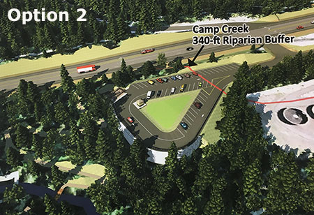
The second design (Option 2) features a triangular loop tucked behind the wastewater treatment plant:

MirrorLake2.09

(click here for a larger map)

This design is an improvement over the first option because it allows for more efficient plowing and use of paved areas. The landscaped center area could even function as a useful place for a few picnic tables for waiting visitors meeting at the trailhead during the snow-free seasons.

The loop in Option 2 could also make it more efficient for law enforcement to patrol and for users to spot suspicious activity. However, like the first design, this option intrudes significantly into the 340-foot protected buffer along Camp Creek and would require removal of a fairly large number of trees.

The third design (Option 3) features a tighter loop that omits the landscaped center included in the second option:

MirrorLake2.10

(click here for a larger map)

Like the first two options, this version extends significantly into the protected buffer along Camp Creek and would require a fair amount of fill and tree removal. Like the second option, Option 3 makes efficient use of paved areas and the loop design would make for easier plowing and patrolling by law enforcement.

The fourth option is the “preferred” option by FHWA and the Forest Service:

MirrorLake2.11

(click here for a larger map)

 This option is preferred mostly because it falls outside the protected 340-foot Camp Creek buffer. I walked the site with the Zigzag District Ranger in late 2014, and while it does make sense as the most compact design, it’s also an attempt to squeeze a lot into a very narrow, surprisingly steep strip of land between the treatment plant and highway.

While the mockup illustration (above) for Option 4 shows a few trees left between the parking area and treatment plant, in reality it would be difficult to achieve the amount of fill required to build the new parking area without removing all of the trees along the north edge of the treatment plant. Over time, this could be remedied with new tree plantings along the fill slope, but in the near term, visitors would enjoy a birds-eye view of the open settling ponds and the treatment plant operators may be concerned about this new level of public visibility.

Tree removal is a concern in all of the designs, as this area contains stands of Alaska cedar, a high-elevation cousin of Western red cedar found throughout the Government Camp area, but relatively uncommon in the Cascades.

MirrorLake2.11a

The graceful, drooping form of Alaska Cedar make it a prized commercial landscape tree

All four options feature a very tight turning sequence for drivers arriving from the west, with a right turn into the shared driveway with the Ski Bowl resort, and almost immediately a second right turn into the trailhead parking. These turns create a blind corner for approaching traffic that probably warrants a deceleration lane along the highway — especially given ODOT’s determination to promote high-speed travel along the loop highway.

No Longer Considered…

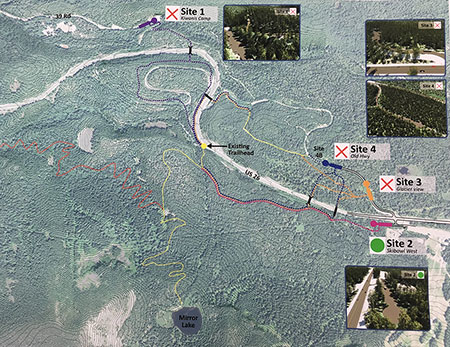
The FHWA and Forest Service have already dropped some intriguing trailhead locations that I will briefly describe here. For context, the map below shows four of the five sites original sites (those located closest to Government Camp) considered — the four final design options now under consideration are all located at Site 2 on this map:

MirrorLake2.12

(click here for a larger map)

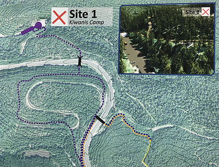
Site 1 is at the end of the Kiwanis Camp Road, which is really an original segment of the Mount Hood Loop Highway:

MirrorLake2.13

(click here for a larger map)

This site already serves as the trailhead for the Little Zigzag Falls trail and a closed section of the old highway leads to the Pioneer Bridle Trail. This site was dropped because of the added distance to reach Mirror Lake and the difficulty in creating a trail crossing over Highway 26 for hikers.

Site 2 is the Ski Bowl location where the previously described design options are still under study:

MirrorLake2.14

(click here for a larger map)

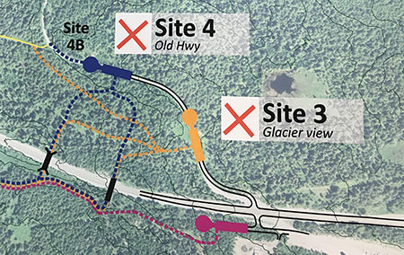
Sites 3 and 4 are located along another portion of the original Mount Hood Highway, opposite Site 2 and the Ski Bowl parking area:

MirrorLake2.15

(click here for a larger map)

The Glacier View snow park and trailhead is already located along this segment of old highway, and the concept behind both Sites 3 and 4 was to build a larger, shared snow park with a pedestrian bridge over Highway 26 to connect to the Mirror Lake trail. These sites were dropped because of the scale and complexity of spanning Highway 26 with a foot bridge, especially after the highway widening project greatly increased the width of the highway, itself.

Site 5 is located at a quarry at the foot of Laurel Hill, below a prominent rocky knob along the highway created by the road cut (and known as the “Map Curve” to ODOT):

MirrorLake2.16

(click here for a larger map)

While this site was dropped because of its distance from Mirror Lake, it nevertheless offers exciting opportunities as an alternative trailhead and the potential for a broader strategy to manage the heavy visitation to Mirror Lake. Part 3 of this series will explore the possibility of a larger trail network and more hiking options as a strategy for reducing the pressure on Mirror Lake in the long term.

Tragedy of the Commons?

As disappointing as it may be to lose the historic Mirror Lake trailhead, there are some clear environmental benefits that could be achieved.

First, the new trailhead will about a mile east of the historic trailhead, meaning a longer hike by about two miles, round trip. While this will make the trail less accessible to young families, it’s also true that the lake is showing serious damage from overuse. If the more distant trailhead discourages a few hikers, that could be a win for the lake.

MirrorLake2.17

The Forest Service has done extensive soil stabilization work at Mirror Lake just to keep pace with heavy foot traffic.

As I have argued before on this blog, placing physical barriers to outdoor recreation is tragically short sighted if our goal as a society it to encourage people to be more active and to enjoy and take responsibility for our public lands. Thus, I favor other strategies for addressing heavy use on trails, including peak parking fees at the busiest trailheads.

Eventually, the Mount Hood National Forest will have to adopt a real parking strategy on some of its most heavily used sites, but the agency so far has not acknowledged that reality. Instead, its planners are viewing washed-out bridges (Ramona Falls) and trailhead closures (Mirror Lake) as helpful interventions to tame the masses. That’s a poor solution pretending to be a strategy.

Nonetheless, the Forest Service is clearly a long way from adopting a comprehensive trailhead parking policy at Mount Hood, so for Mirror Lake. Making the hike more difficult is probably the only near-term option if the number of hikers can actually be reduced, however short-sighted the approach.

MirrorLake2.18

Rill erosion like this is common where Highway 26 abuts Camp Creek, pouring road gravel and pollutants directly into a protected salmon and steelhead stream

Moving the Mirror Lake trailhead could also allow for a meaningful effort by ODOT and the Forest Service to protect Camp Creek from sediment and runoff pollution from Highway 26.

While ODOT is spending tens of millions to carve away solid rock slopes in order to widen the highway, no funds were set aside to improve stream protection for Camp Creek. The creek is home to protected salmon and steelhead, and eventually it flows into the Sandy River — one of the few spawning streams in the Columbia River system with no dams to block fish passage.

MirrorLake2.19

Highway runoff now pours sediment and pollutants directly into Camp Creek at the Mirror Lake trailhead.

MirrorLake2.20

Looking east along Camp Creek (on the right) and Highway 26 showing rill erosion directly from the road surface into the stream

The Forest Service has indicated a commitment to decommission and restore the historic trailhead once the new trailhead has been constructed. That’s a good start, but it’s unclear whether channeling highway runoff away from Camp Creek is part of that plan.

Ideally, ODOT would construct a concrete curb to divert highway runoff for the entire 1-mile highway section that abuts Camp Creek, from the historic trailhead east to the Ski Bowl entrance.

The actual drainage design would more complex, as the amount of runoff here is clearly enough to erode dozens of rills into the shoulder and directly to Camp Creek, as shown in the photos above. But the removal of the Mirror Lake trailhead represents an opportunity for ODOT to show it cares about more than just moving ski traffic at slightly higher speeds.

The agency also has the funds to address highway runoff into Camp Creek as part of the current widening project, as all ODOT projects include hefty contingency set-asides for just this sort of unanticipated expense — as much as one third of the overall project budget is typically “contingency”.

How to Comment

If you love Mirror Lake or care about Camp Creek, it’s worth commenting on the trailhead relocation project, if only because precious few will take the time to do so. The FHWA, ODOT and Forest Service really do take public comments into consideration, especially when it brings new information to their decisions.

MirrorLake2.21

The resort village of Government Camp from above Mirror Lake.

Here are two suggested areas to focus on your comments on:

What would you like to see in the preferred alternative (Option 4)?

Are you frustrated with the winter closure of the existing Mirror Lake trailhead? Be sure to mention this in your comments on the proposed new trailhead, as it will need to be design to be plowed and subsequently added to the Snow Park system to serve as a year-round trailhead.

Consider commenting on other trailhead amenities, as well, such as restrooms, secure bicycle parking, trash cans, drinking fountain, signage, picnic tables, a safe pedestrian crossing on Highway 26 for hikers coming from Government Camp or any other feature you’d like to see.

How would you like to see Camp Creek protected?

The project vaguely proposes to restore the existing shoulder parking area to some sort of natural condition. Consider commenting on how this restoration might work to benefit Camp Creek, which is now heavily affected by highway runoff and the impacts of parking here.

In particular, mention the need to divert highway runoff away from Camp Creek for the entire 1-mile stretch from the old trailhead to the Ski Bowl entrance. The proposed parking area restoration is the perfect opportunity to address the larger need to improve the watershed health.

You can comment to Seth Young at the Federal Highway Administration via e-mail or learn more about the project here:

Mirror Lake Trailhead Project Information:

___________________

 Federal Highway Administration

Seth English-Young, Environmental Specialist

Western Federal Lands Highway Division

610 East Fifth Street

Vancouver, WA 98661-3801

Phone: 360-619-7803

Email: seth.english-young@dot.gov

 ___________________

Subscribe to Project Newsletters

To be added to our mailing list, please send an email to seth.english-young@dot.gov.

 ___________________

For U.S. Forest Service specific questions contact:

Laura Pramuk

Phone: 503-668-1791

Email: lbpramuk@fs.fed.us

___________________

 Thanks for helping guide the future of Mirror Lake!


A New Vision for Mirror Lake (Part 1 of 3)

Summer evening view of Mount Hood from Mirror Lake

Summer evening view of Mount Hood from Mirror Lake

Big changes are coming to the Mirror Lake Trail on Mount Hood, perhaps the single most visited trail on the mountain. This is the first of three articles on the future of Mirror Lake, and the need for a broader vision to guide recreation in the area.
____________

As part of the unfortunate widening of the Mount Hood Highway currently underway west of Government Camp (see this article for more on the subject), the Oregon Department of Transportation (ODOT) has persuaded the U.S. Forest Service to close the existing, historic trailhead for the Mirror Lake Trail.

ODOT claims safety is the chief concern, a point I will visit later in this series. For now, though, it looks like our highway department will close yet another roadside trailhead in a campaign to gradually morph the Mount Hood Highway into full-fledged freeway.

Going back to the beginning…

Just as Mount Hood generally bears the development pressures of being an hour from Portland, and along transportation corridor that dates to the 1840s, Mirror Lake has long carried the burden of being the closest mountain lake to Portland, and the first easily accessible trailhead along the loop highway.

Because of its proximity, the lake shows up on the earliest maps of the Government Camp area, when the Mount Hood Loop Highway had a very rough, early alignment and was not yet a loop. The original Skyline Trail map (below) from the early 1900s shows Mirror Lake just west of the new trail, and a version of the early loop road before the Laurel Hill switchbacks were built.

1920s-era map of Mount Hood and the Government Camp area

1920s-era map of Mount Hood and the Government Camp area

By the early 1920s, the effort to complete the loop highway was in full swing, including the graceful switchbacks that scaled Laurel Hill (below), the spot where Oregon Trail immigrants had to lower their wagons with ropes because of the steepness of the terrain. Surprisingly, a formal trail to Mirror Lake had not yet been constructed by this time.

1920s map of the first paved alignment of the Mount Hood Loop Highway at Government Camp

1920s map of the first paved alignment of the Mount Hood Loop Highway at Government Camp

Other maps from the early 1900s (below) tell another story about Mirror Lake: it was within the northern extent of the Sherar Burn, a massive fire that had destroyed forests from the Salmon River to Camp Creek. As recently as the 1980s, bleached snags from the fire were standing throughout the Mirror Lake area.

1920s map showing the Sherar Burn extent in the Mirror Lake area

1920s map showing the Sherar Burn extent in the Mirror Lake area

The Sherar Burn of the mid-1800s created vast tracts of huckleberries across the area, and during the early days of the highway, huckleberry pickers were a common sight, selling coffee cans of fresh berries to mountain visitors (below).

Huckleberry pickers in the 1930s at the Little Zigzag River bridge, below Laurel Hill

Huckleberry pickers in the 1930s at the Little Zigzag River bridge, below Laurel Hill

Mirror Lake, itself, looked quite different in the 1920s, too. Today’s tree-rimmed lake was mostly surrounded by burned snags and fields of beargrass and huckleberry in the 1920s (below).

Mirror Lake in the late 1920s

Mirror Lake in the late 1920s

Sometime in the late 1920s or early 1930s, a new trail was constructed from the new highway to Mirror Lake. The trail began at a sharp turn on the old highway, traversing above the north shoulder of Yocum Falls on Camp Creek, crossing to the south side of the creek at the spot where the modern trailhead is located today (see maps below).

This lower section (from the bend in the old highway to the modern trailhead) of the original Mirror Lake trail was destroyed just 25 years later, when the modern highway grade cut through the area. This portion of the old highway still exists in this area, accessible from the Laurel Hill historic landmark pullout (currently closed because of the highway widening).

1930s map of the original Mirror Lake Trail

1930s map of the original Mirror Lake Trail

1930s map of the Mirror Lake Trail and surrounding area

1930s map of the Mirror Lake Trail and surrounding area

When the original Mirror Lake Trail was built, the trailhead was located just a few yards beyond an impressive roadside viewpoint of Yocum Falls on Camp Creek (below). Today, the forest has recovered so completely in this part of the Sherar Burn that this viewpoint is completely overgrown. It is still possible to visit Yocum Falls from the old highway grade, though, by following rough use trails.

Yocum Falls as it once appeared from the original Mount Hood Loop Highway

Yocum Falls as it once appeared from the original Mount Hood Loop Highway

The lower section of the original trail seems to have followed the rambling extent of Yocum Falls quite closely before the trail was destroyed by the modern highway. While the current trailhead gives a brief glimpse of the top of the falls, the old route seems to have provided a nice view of the falls since lost (more on this topic in the third part in this series).

Today, the modern Mirror Lake trailhead continues to provide a popular drop-in hike for families and casual hikers, but the convenience comes at a price. The shoulder parking area is large enough to allow up to 100 cars, and on busy weekends, still more hikers park along the highway all the way to Government Camp, walking the highway shoulder to reach the trailhead.

The Mirror Lake Trail was never designed to handle this much traffic, nor is the small lake able to handle so many visitors. These concerns are part of the Forest Service thinking in why a new trailhead should be constructed.

Camp Creek suffers from its close, unprotected proximity to Highway 26 and the Mirror Lake Trail parking.

Camp Creek suffers from its close, unprotected proximity to Highway 26 and the Mirror Lake Trail parking.

Meanwhile, the 1950s-era trailhead pullout in use today was built at a time when little thought was given to environmental impacts. As a result, highway fill was pushed to the edge of Camp Creek, exposing an important salmon and steelhead stream to heavy loads of silt and pollution from parked vehicles. A visit to Yocum Falls, just downstream, reveals a troubling amount of road debris and the sharp odor of pollution in an otherwise healthy stream corridor.

While these growing impacts on Mirror Lake and Camp Creek aren’t the reason ODOT gives for closing the current Mirror Lake Trailhead, they are compelling arguments to consider.
____________

The next part of this 3-part series will take a closer look at ODOT’s arguments for closing the existing trailhead and the Forest Service proposal for a new trailhead located east of the existing access.

A Tale of Two Ranger Stations: Part One

The new Zigzag Ranger Station

The new Zigzag Ranger Station

Mount Hood National Forest (MHNF) recently completed a much-needed, $1.7 million overhaul of its dated Zigzag Ranger Station, the de-facto visitor gateway to Mount Hood. The new ranger station and visitor center not only provide a modern facility for forest visitors, it was also designed to compliment the rare collection of historic forest buildings that sprawl across the Zigzag campus, the entirety of which was listed on the National Historic Register in 1986. It’s a big step forward for Mount Hood.

Meanwhile, the Upper Sandy Guard Station, located just a few miles away near popular Ramona Falls, has fallen into serious disrepair, all but abandoned after years of neglect. The Upper Sandy Guard Station is also listed on the National Historic Register (in 2009), yet now is on the brink of collapse. Basic repairs would cost a fraction of what the Zigzag project cost, so why the disparity?

Upper Sandy Guard Station in better days (1930s)

Upper Sandy Guard Station in better days (1930s)

This is a two-part story about the two historic ranger stations, one reborn and the other about to die, and how this frustrating chain of events came to pass. And, most importantly, how the Upper Sandy Guard Station might still be saved.

No Welcome Mat?

Mount Hood has always lacked a truly functional visitor center. For years the 1960s-era Zigzag ranger station, with its cluttered, cramped public counter, served as the main stop for visitors new to the area. The old Mount Hood National Forest headquarters was actually worse, located in a rundown section of east Division Street in Gresham, next to mini-storage. It was hardly an inspiring “gateway” to Mount Hood.

A relatively new forest headquarters building was constructed in Sandy in the 1990s with a more aesthetic design the 1990s, but is awkwardly located in a suburban industrial park, where the public is discouraged from visiting the building. Few travelers even realize they are passing the building, though it is within plain view of the Mount Hood highway.

The "new" (1990s) Mount Hood headquarters hides in an industrial park on the outskirts of Sandy.

The “new” (1990s) Mount Hood headquarters hides in an industrial park on the outskirts of Sandy.

The new headquarters in Sandy was a missed opportunity to build a visitor gateway on a scale that reflects the millions who visit the mountain each year. Most regrettable was the decision to locate the building two miles from downtown Sandy, where it could have been easily found by visitors, but also would have complemented other visitor facilities there, and reinforced the tourism economy that is so important to the town of Sandy.

This small building served as the Zigzag Ranger Station until 2013

This small building served as the Zigzag Ranger Station until 2013

By the late 1990s, the Forest Service had formed a partnership with Clackamas County and the Mount Hood Chamber to open a new visitor facility in a vacant commercial space on the Mount Hood Village RV resort grounds, a few miles west of Zigzag. This odd arrangement operated into the mid-2000s, but was eventually closed due to county budget cuts. Relatively few visitors found their way to this location, anyway, so the closure mostly impacted hikers who had enjoyed the convenience of a public restroom.

After the RV resort experiment, the visitor gateway to Mount Hood reverted to an outdoor kiosk at the 1960s-era Zigzag Ranger Station. A portable toilet was added to the parking area to complete the outdoor facilities. This arrangement served as the main visitor experience until last summer, when the handsome new ranger station and visitor center opened.

The original Zigzag Ranger Station was built by the CCC in 1935

The original Zigzag Ranger Station was built by the CCC in 1935

The good news is that the original Civilian Conservation Corps (CCC) era Zigzag Ranger Station also survives, along with nineteen other historic structures on the Zigzag site. To the credit of the MHNF, all of these structures have been well preserved over the decades for their historic significance at a time when historic forest service structure around the nation are rapidly fading away.

While the visitor gateway to Mount Hood bounced around over the past several decades, other national forests in the region were moving ahead with bold visitor centers that signaled a new focus on recreation. Notably, the Willamette National Forest built four expansive new ranger stations in the 2000s on far less travelled forest gateways than loop highway approach to Mount Hood, including a dramatic new Detroit Ranger Station (below), which opened in 2009.

The grand Detroit Lake Ranger Station and visitors center

The grand Detroit Lake Ranger Station and visitors center

Meanwhile, the Mount Hood National Forest limped along with the fading 1960s era Zigzag Ranger Station and a similarly dated and cramped Estacada Ranger Station. The Hood River Ranger Station is even worse, a leased space until recently, and little more than a portable building.

Perhaps a bit of intra-agency envy ensued, as the Mount Hood National Forest finally assembled funding in 2012 for a major upgrade to the Zigzag Ranger Station. Requests for construction bids were titled the “Mount Hood Scenic Byway Portal Project”, a fitting acknowledgement of the main focus of the building upgrade.

The New Zigzag Ranger Station

The new Zigzag Ranger Station (below) is tucked into the historic complex at Zigzag, east of the original ranger station and incorporating the 1960s era building. Though not as grandiose as the new gateway structures in nearby Willamette National Forest, the new Zigzag facility has an attractive, rustic design that complements the surrounding historic structures rather than overshadow them.

Visitor Center at the new Zigzag Ranger Station

Visitor Center at the new Zigzag Ranger Station

DKA Architecture of Seattle designed the project, which includes a remodel of the old 1960s structure with new additions that double the square footage of the facility. Payne Construction of Portland was selected from a competitive bid to build the new facility.

The new ranger station and visitor center has three main elements: (1) the indoor reception and visitors area, backed by administrative offices and conferences rooms, (2) an outdoor plaza and display gazebo and (3) separate public restrooms. The new ranger station structure is clad in clapboard siding and shingled gable roof, echoing the Cascadian architecture of the original 1935 structure.

The new Zigzag Visitors Center is fronted with a small plaza and information gazebo

The new Zigzag Visitors Center is fronted with a small plaza and information gazebo

HBB Landscape Architecture of Seattle designed the mostly rustic landscaping around the new structure. Modern touches to the landscape include a concrete, railed wheelchair ramp and sleek lighting bollards. The landscape design appropriately focuses on native plants, including sword fern, salal, Oregon grape, rhododendron and even some stonecrop tucked into a rock retaining wall, all just getting started, but well suited to thrive here.

Wheelchair parking is provided close to the gazebo with ramps to both the restroom and visitor center

Wheelchair parking is provided close to the gazebo with ramps to both the restroom and visitor center

The very modern public restroom is located across the small parking area from the new ranger station and visitor center. The proximity to US 26 and dramatic improvement over the portable toilets (yikes!) that used to be here will make these restrooms a popular stop along the loop highway – and hopefully inspire travelers to take a few minutes and explore the visitor center, as well.

The restroom exterior design has a nice touch: the traditional 1930s “open pine tree” logo is incorporated into the center gable post, a thoughtful nod to the collection of historic CCC buildings that surround the new facility. The restroom includes a single bicycle rack — minimal, but easy to expand over time, thanks to the spacious plaza in front of the restroom.

New restrooms at the Zigzag Ranger Station and Visitor Center

New restrooms at the Zigzag Ranger Station and Visitor Center

The informational kiosk in the plaza is still not complete (assuming there will eventually be information posted here!), which apparently inspired Zigzag staff to begin tacking fliers to the brand new siding near the front door with thumbtacks. That’s not how most of us would treat freshly painted siding on our homes, so it’s disappointing to see on such a beautiful new facility (not to mention that a nearly identical poster hangs two feet away, in the window on the main door).

Tacky, tacky -- hopefully, the Zigzag Ranger District will give the new facility the quality informational and interpretive displays it deserves

Tacky, tacky — hopefully, the Zigzag Ranger District will give the new facility the quality informational and interpretive displays it deserves

Likewise, the Zigzag District staff has chained a cheap galvanized trashcan to the sleek new entry rails at the main entrance stairway — jarring against the handsome new architecture, and perhaps just a temporary solution. Hopefully, a permanent trash and recycling station is on order for the plaza area!

Another gap in an otherwise fine new design for the ranger station is the lack of benches and tables outside the visitor facility. It’s another detail that can easily be addressed, and perhaps was anticipated in the landscape design, as well. The new ranger station is a pleasant place to be, and visitors will want to spend time here.

Nothing like the sight of a trashcan to say "welcome to Mount Hood!"

Nothing like the sight of a trashcan to say “welcome to Mount Hood!”

Overall, the new Zigzag ranger station and visitors center is a very big step forward, and a welcome development for those discovering Mount Hood for the first time. While the $1.7 million price tag may seem steep to some, it’s a very reasonable expense for a facility of this scale — and especially given the context of some 2.6 million visitors pouring into the area each year. Hopefully, similar facilities will eventually be constructed at the Hood River and Clackamas gateways to Mount Hood, as well.

But for many, the substantial price tag for the new Zigzag ranger station raises another question: if we can afford to build a brand new station at Zigzag, why can’t we afford to simply stabilize the beautiful Upper Sandy Guard Station, which teeters on the brink of being lost forever?
_____________________

Next: Part Two of this article looks at the fate of the Upper Sandy Guard Station

Ski Traffic & the Loop Highway: Part 2

The winter weekend crush of skiers is nothing new on Mount Hood

The winter weekend crush of skiers is nothing new on Mount Hood

(This is the second in a two-part article. The first part focused on the latest plans to add more parking to the Meadows resort, another step in the wrong direction for Mount Hood, but one that (unfortunately) has already been approved by the U.S. Forest Service. This part focuses on the future, and a promising new strategy that seems to finally be turning the page on an era when ODOT and the Mount Hood ski resorts simply paved their way out of weekend traffic problems with more parking and wider highways.)
__________________

Since the early days of developed snow sports on Mount Hood in the 1920s, winter weekend traffic jams have been the norm. The cars have changed (and so has the highway, regrettably), but the same bottlenecks appear in pretty much the same spots, as thousands of Portlanders pour into the ski resorts over a few short winter weekends each year.

Intrepid auto tours reached Government Camp on dirt roads years before the loop highway was completed in the early 1920s

Intrepid auto tours reached Government Camp on dirt roads years before the loop highway was completed in the early 1920s

From the beginning, there have been overflow parking lots, ski buses, shuttles — even an aerial tram in the early 1950s known as the Skiway — all in an attempt to stem the weekend ski traffic.

In 2013, the Oregon Department of Transportation (ODOT), in partnership with the U.S. Forest Service, the Federal Highway Administration and Clackamas and Hood River county officials, kicked off yet another effort to address the winter traffic overload.

In the 1920s, Government Camp was the center of winter activity -- and overflowing with cars

In the 1920s, Government Camp was the center of winter activity — and overflowing with cars

While this is just the latest of several ODOT-led efforts over the years to better manage the Loop Highway, the draft Mount Hood Multimodal Transportation Plan (MHMTP) is the best effort yet. While still only a document full of recommendations, the new plan offers real promise that federal, state and local officials are now more serious about managing the relatively short season of ski traffic gridlock.

Timberline Lodge was overflowing with cars as soon as it opened in the late 1930s

Timberline Lodge was overflowing with cars as soon as it opened in the late 1930s

Instead of attempting to rebuild the entire highway corridor to meet the peak demands of ski resort traffic that occurs over a few weekends each year, the MHMTP focuses instead on low-cost, high-impact tools. This is a radical and positive change in mindset — even if the plan itself still has a few gaps.

The stakes are high when it comes to managing traffic on Mount Hood. The ski resorts have little incentive to do anything except ask the general public to cough up more tax dollars for ever-wider highways. After all, it’s a sweet deal for the resorts and skiers, alike: in Oregon, just one in 25 residents ski, so the subsidy for highway projects catering to ski traffic is enormous.

ODOT is currently seeking bids in the latest round of road widening, this time along the slopes of Laurel Hill in what will eventually total more than $60 million in state gas tax funding over the past decade to widen the Loop Highway from Brightwood to Government Camp.

Camp Creek takes the brunt of trash and pollution from US 26. This scene is the unimproved roadside trailhead at Mirror Lake, where a chemical toilet (and associated trash) sits precariously above a steep bank dropping directly into the stream

Camp Creek takes the brunt of trash and pollution from US 26. This scene is the unimproved roadside trailhead at Mirror Lake, where a chemical toilet (and associated trash) sits precariously above a steep bank dropping directly into the stream

Just a few hundred yards downstream from the scene in the previous photo, Camp Creek spills over beautiful Yocum Falls, a seldom-visited spot bypassed by the modern highway. The pool below the falls is sullied with plastic cups, sport drink bottles and tires that have found their way into the stream from the highway

Just a few hundred yards downstream from the scene in the previous photo, Camp Creek spills over beautiful Yocum Falls, a seldom-visited spot bypassed by the modern highway. The pool below the falls is sullied with plastic cups, sport drink bottles and tires that have found their way into the stream from the highway

The traditional “building your way out” mindset has been bad for business in the local communities along the highway. The wider, noisier road has made it even less attractive for day tourists to risk a stop at the remaining shops and restaurants in the corridor. Worse, the huge 5-lane cross sections built on Highway 26 over the last decade have effectively cut the mountain villages in half by creating a scary barrier for local traffic to navigate, whether on foot, bicycle or in a vehicle.

Widening the Loop Highway is even worse for the natural environment, as highway trash, polluted runoff and blown gravel enters directly into the Salmon River, Still Creek, Camp Creek (pictured above) and the Zigzag River. All four streams serve as important salmon and steelhead habitat, a fact lost on the rush to make room for a few weekends of ski traffic each year.

A New Direction?

The Mount Hood Skiway was an early 1950s experiment to lessen parking pressure on Timberline Lodge - it failed, but may have been ahead of its time!

The Mount Hood Skiway was an early 1950s experiment to lessen parking pressure on Timberline Lodge – it failed, but may have been ahead of its time!

ODOT’s new MHMTP is both comprehensive and innovative. The plan is guided by the following objectives for how future travel should occur on the mountain:

• Improved highway safety for all users
• Expanded travel options year-round
• Reduced peak travel demand
• Enhanced mobility and access to recreation and local communities
• New projects should be financially feasible and sustainable
• New projects should be achievable in the next 15 years

The new focus on cost-effectiveness and a broader definition of desired outcomes beyond simply chasing traffic is new for ODOT — and for Mount Hood. It follows the lead of urban areas across the country, where cities are increasingly moving away from big-ticket road projects that seldom provide the advertised safety or mobility benefits used to justify them, and toward more practical solutions that have fewer unintended consequences.

A decade of futile "widening for safety" projects in the Highway 26 corridor has mostly resulted in dividing local communities and increasing highway runoff, with little traffic benefit

A decade of futile “widening for safety” projects in the Highway 26 corridor has mostly resulted in dividing local communities and increasing highway runoff, with little traffic benefit

To achieve these core objectives in managing the Mount Hood travel corridor, the MHMTP lays out four areas of proposed action – this is the real substance of the plan:

1. Better managing the system: in this area, the plan calls for another plan known as a “concept of operations”, which is transportation jargon for an operations blueprint for the Mount Hood loop from the City of Sandy to Hood River. Elements of an operations blueprint could range from web-based traveler information to new or upgraded electronic message signs along the highway, with real-time updates on traffic, parking, transit and emergencies.

The goal of this element of the MHMTP is to make the best use of the system through better-informed travelers and to better coordinate the various public agencies (ODOT, the Forest Service and the two counties) involved in operating the road system.

How it could be better: the details of the “concept for operations” aren’t nailed down at this point (thus the need for another plan), but one strategy not mentioned in the list of possibilities is variable speed limits along the entire loop. This key recommendation from ODOT’s 2010 Highway 26 Safety Audit deserves to be a priority above other, more costly highway projects already moving forward in the area. DOTs around the country are using this technology with excellent results in improving safety and traffic efficiency, and ODOT should join the movement.

An even larger gap in the strategy is an unwillingness by ODOT and the Forest Service to require the ski resorts to adopt peak pricing as a means to help spread out demand. The resorts are loathe to do this, given their troubled future (as described in Part 1 of this article), but if all three major resorts adopt the same policy, they will at least retain their current competitive positions with one another, while Mount Hood’s communities and environment would benefit from a coordinated effort to spread out the highway demand.

Not in the plan: pricing incentives for parking and lift tickets at the big three resorts to spread demand from weekend peaks

Not in the plan: pricing incentives for parking and lift tickets at the big three resorts to spread demand from weekend peaks

Sadly, it will be a very long time before the Forest Service asks the resort to adopt more aggressive peak pricing for lift tickets, but that is the best long-term solution available for spreading out ski demand. Short of that, ODOT holds the cards for managing parking, as all parking along the mountain portion of the Mount Hood Loop Highway falls within a state-designated SnoPark permit area.

Currently, ODOT charges a generic fee for annual and day passes to park at the SnoPark lots (including all three ski resorts), but the agency should consider using these permits to better manage demand on the highway. This is a very low-cost strategy to avoid some very high-cost road widening projects.

2. Bicycle and pedestrian projects: this much-needed element of the plan calls for improved bike and pedestrian crossings at key locations along the loop highway. Highway widening is also called for to allow for more shoulder space for bicycles, along with bike safety improvements at key intersections and traveler information for bicycles. While not driven by ski resorts, this element of the plan embraces the potential for Mount Hood to become a more balanced, year-round recreation destination, and the Loop Highway becoming less of a barrier to hikers and cyclists.

Notably, the famously crowded Mirror Lake trailhead is called out for relocation to address safety issues with the current trailhead. The new trailhead could be sited across the highway, accessed from an existing section of the Historic Mount Hood Loop Highway (that now serves the Glacier View SnoPark), and connected to the current trailhead with a new pedestrian bridge over US 26.

Rumble strips are very effective at keeping distracted drivers out of bike lanes, but bikes also need enough lane space to keep away from the rumble strip

Rumble strips are very effective at keeping distracted drivers out of bike lanes, but bikes also need enough lane space to keep away from the rumble strip

How it could be better: “widening” for bicycle lanes is a default recommendation that you might expect from ODOT, but the lanes along the Mount Hood loop are already very wide in many spots, so keep your fingers crossed that our highway planners are judicious about where to actually widen the road. In most cases, simply providing rumble strips along the shoulder stripe would go a long way to keep cycles safe from motor vehicle traffic, and require fewer subalpine trees to be cut for road widening.

A major gap in this element of the MHMTP is lack of policy direction on speeding or travel speeds — two of the three main contributors to serious accidents identified in the 2010 ODOT safety study (with winter conditions as the third).

Extending and enforcing the existing ODOT safety corridor and 45 mph speed limit from Rhododendron to the Hood River Meadows entrance to Mount Hood Meadows would make cycling along this most mountainous portion of the loop highway much safer – which in turn, makes cycling more attractive, especially on the lower sections of the loop that are generally snow free year-round.

"Widening for bicycle lanes" sounds easy, but the devil is in the details when the road travels through public forest lands

“Widening for bicycle lanes” sounds easy, but the devil is in the details when the road travels through public forest lands

3. Improved transit service: The MHMTP plan calls for new transit from Sandy to the mountain, and Clackamas County recently received a US Department of Transportation grant to expand its Mount Hood Express bus service from Sandy to Ski Bowl, Government Camp and Timberline Lodge. Rides are $2 each direction, with ten buses daily during the ski season, seven in the off-season. The trip from Sandy to Government Camp takes about 55 minutes and Timberline Lodge at about 75 minutes, so quite competitive with driving times and much less expensive.

It’s a good start, and long overdue. The fact that almost all traffic heading to the mountain during the winter season is destined for Government Camp, Timberline or Meadows makes the Mount Hood area highly serviceable with transit, provided a long-term funding mechanism can be found.

For too long, a very limited supply of shuttles and private ski buses at the Mount Hood resorts have been the sole transit option along the loop highway

For too long, a very limited supply of shuttles and private ski buses at the Mount Hood resorts have been the sole transit option along the loop highway

How it could be better: The proposed transit service in the MHMTP is great if you’re coming from Sandy — or able to drive and park your car there — but it doesn’t allow for truly car-free trips to the mountain in a region that is increasingly interested in having this option.

For years, people have wondered aloud about “extending MAX to the mountain”, but that will never happen — the cost would be astronomical and the ridership on the best of days wouldn’t come close to justifying the cost. But bus transit is completely within reach, and well-suited to the demand.

A proposal called “The Boot Loop” on this blog showed how it could be done — save for public and private interests along the loop highway coming together to make it happen. Let’s hope the Mountain Express pilot project is just the beginning of a more comprehensive transit system on Mount Hood and in the Gorge.

4. Safety projects: several critiques of ODOT’s ill-conceived “widening for safety” campaign along the Mount Hood loop have appeared in this blog over the past few years, and thankfully, some of the worst elements of the most recent phase between Rhododendron and Government Camp have been dropped.

Most recently, ODOT failed to receive construction bids within its project budget for this latest phase, and that is potentially good news if it means that some of the remaining bloated, environmentally destructive elements of the project (like cutting back cliffs on Laurel Hill) are scaled back.

Given this context, the safety projects contained in the MHMTP plan are refreshingly sensible and practice — truly “safety” projects, and not just an old-school highway widening agenda wrapped in an attractuve safety package.

ODOT owes the rural communities (like Rhododendron, above) along the loop highway retrofits to undo the damage from the "widening for safety"

ODOT owes the rural communities (like Rhododendron, above) along the loop highway retrofits to undo the damage from the “widening for safety”

How it could be better: travel speed is the single most important lever for highway engineers to reach for if improved safety is truly the desired outcome. ODOT was bold and forward-thinking when it adopted a safety corridor along a portion of Highway 26 several years ago, and especially when the agency adopted a 45 mph speed limit from Wildwood to Rhododendron.

There’s no reason why this successful strategy can’t be extended for the remainder of the ski commute along the Loop Highway, to the lower entrance at Mount Hood Meadows. As the 2010 ODOT safety audit clearly showed, nearly ALL of the serious accidents in this corridor were directly tied to heavy winter travel, and especially weekends, when the predictable crush of day skiers descends upon the mountain.

What’s Next?

ODOT will be wrapping up the MHMTP shortly. You can track the final recommendations on their project website:

Mount Hood Multimodal Transportation Plan website

As the MHMTP moves forward toward funding, the focus will shift to Clackamas and Hood River counties, the Forest Service, ODOT and the ski resorts working collaboratively to bring the various strategies completion. The plan sets forth three tiers of project, but all recommendations fall within a (relatively) short window of 15 years.

The Mirror Lake trailhead could see big changes under the proposed MHMTP plan

The Mirror Lake trailhead could see big changes under the proposed MHMTP plan

ODOT has an institutional habit of saying it “owns” the highways, but in fact, the public owns it – that’s us! Thus, it falls upon the true owners of the Loop Highway to track the details — the specific projects that will carry out the new direction called for in the MHMTP. Perhaps more importantly, it falls upon us to speak out against more funding of old-school road widening projects cloaked as “safety improvements” that could effectively cancel out the MHMTP proposals.

Over the next few years, the recommendations in the MHMTP will gradually be funded through ODOT’s statewide transportation improvement program and similar capital funding programs at the local level. Watch this blog for more details on how the dollars actually roll out in coming years on our beloved loop highway!

Alva Day and the Lost Lake Highway

Timeless classic: 1920s Postcard view of Mount Hood from Lost Lake

Timeless classic: 1920s Postcard view of Mount Hood from Lost Lake

The Hood River History blog recently featured a series that caught my eye: a local family packing up their car for a camping trip to Lost Lake. The images were from a series captured in the 1939s and early 40s by Alva Luman Day, a local photographer whose legacy as a figure in Mount Hood history is only now beginning to emerge.

As happens with most history research, digging a bit deeper into the story of Alva Day’s camping trips to Lost Lake revealed more than a few surprises. This article is the story of how the modern-day highway to Lost Lake came to be, and how the life of Alva Day is intertwined in this story.

Alva Luman Day

Alva Day was born in 1887 in Colorado and moved to Oregon by the early 1900s. Day married Io Stewart in 1908, and they gave birth to their son Carroll Stewart Day in July 1910. Sometime after arriving in Oregon, Alva spent time in Alaska, though it is unclear whether his wife and young son traveled with him. But by 1918, he was back in Hood River to stay, working for Pacific Power and Light until he retired in the 1940s.

Alva Day clamming in Ketchikan - 1917 (Source: Hood River History)

Alva Day clamming in Ketchikan – 1917 (Source: Hood River History)

The above photo from Hood River History shows a young Alva Day during his Alaska years, posing for his camera during a clam dig near Ketchikan in 1917. He was just shy of 30 years old in this photo, and about to make his permanent move to Oregon.

Alva Day was a skilled and prolific photographer. The History Museum of Hood River has more than a thousand of Day’s images in their collection. The Lost Lake series is typical of his photos, too. He had an eye for detail and composition, but with a journalist’s instinct for storytelling. He often added his own, handwritten notes to the back of his prints, gradually building a rich historic legacy that we are just beginning to appreciate today.

1920s postcard view of Lost Lake from nearby Raker Point

1920s postcard view of Lost Lake from nearby Raker Point

Alva Day’s family trips to Lost Lake by automobile were a relatively new phenomenon in the 1930s. A rough wagon road had been constructed in 1905, but soon fell into disrepair, and was never passable to automobiles. The new Lost Lake Highway had only been completed in the early 20s and was still unpaved when the Day family made their camping treks. In fact, most of the public lands around Mount Hood were still roadless at the time, as commercial logging (and its roads) would not emerge a major focus of the U.S. Forest Service until the 1950s.

Construction of the Lost Lake Highway began in 1919, spurred by construction of the new Mount Hood Loop Highway, and the excitement over the recently completed Columbia River Highway. The Lost Lake Highway was conceived as a joint venture between the U.S. Forest Service and Hood River County, climbing 14 miles from the company mill town of Dee to the lake. Roughly two-thirds the road was on county land, and the upper third inside the Oregon (later renamed Mount Hood) National Forest boundary.

Lost Lake is prominent on this 1920s map of the Mount Hood Loop (Source: The Oregonian)

Lost Lake is prominent on this 1920s map of the Mount Hood Loop (Source: The Oregonian)

The project got off to a rough start, and endured many setbacks and delays over four years of construction. From the beginning, there were worker shortages, with District Ranger Warren Cooper making trips to Hood River in September 1919 in search of men willing to join the effort:

“We are going to have the road finished for motor traffic by next summer if we can get help. We need ten men now” said Cooper at the time. But by November of that year, snow shut down road construction until the following spring of 1920.

By mid-summer of 1920, Forest Supervisor Thomas H. Sherrard had 12 workers pushing forward on the National Forest portion of the project in order to complete the final two miles to the lake. By September of that year, the Oregonian reported the construction to be “progressing fast” with the “gem of the Cascades to be open to auto travel next year.”

Hood River photographer Fred Donnerberg captured this image of the road under construction in the summer of 1920 (note the boxes of explosives in the background) (source: Hood River History)

Hood River photographer Fred Donnerberg captured this image of the road under construction in the summer of 1920 (note the boxes of explosives in the background) (source: Hood River History)

Still more delays followed, with the “finished” road rough and still impassable to most cars by the end of 1921. With the route largely in place, a gravel surface would be added in the summer of 1922, finally making it a truly durable “highway” for auto travel. The Oregonian reported the completion of the clearing and grading phase in the fall of 1921 as follows:

“When the last charge of TNT was exploded, removing the last barrier of boulders and a giant fir stump, members of the 20-man forestry crew paused on the lake’s edge and gave a huzza that echoed and re-echoed through the forest. Then they cleared away the debris, the new road was open, and one of the gems of the Oregon National Forest was made accessible to motorists of the Hood River Valley, or their visitors from Portland, over the Columbia River Highway.

“The forestry crew broke camp today, closing the new dirt grade with a barricade of felled trees as they left the district… It is planned that the new grade of approximately five miles shall be surfaced with crushed rock next summer… The cost of grading the stretch, which penetrates a district of magnificent firs and cedars, was about $18,000.”

It turns out that Alva Day had an important role in the completion of the Lost Lake Highway, too. He was an avid sportsman, and secretary of the Hood River Game Protection Association at the time, one in a series of prominent roles he played over his life advocating for hunting, fishing and wildlife conservation.

Alva Day (left) overseeing the release of hatchery fry in 1933 (source: Hood River History)

Alva Day (left) overseeing the release of hatchery fry in 1933 (source: Hood River History)

The game association was a strong advocate for the project, promoting the idea and leading critical local fund-raising efforts for the county portion of the project in 1919 and 1920 to keep construction on track.

By the mid-1920s, thousands of cars were streaming up the dusty, gravel road to Lost Lake, and Alva Day was undoubtedly among the visitors. Responding to this instant popularity, the Forest Service gave the green light to several summer cabins and a small resort in the years that followed, and later constructed the beautiful campground we know today. Lost Lake was now a major tourism destination, drawing tens of thousands of visitors each year to its postcard shoreline views of Mount Hood, framed by ancient cedars.

Day Family Trips to Lost Lake

Alva Day’s involvement in the conception and completion of the Lost Lake Highway adds new meaning to the series of photos he captured on family outings to Lost Lake in the 1930s and 40s. He loved the lake, and according to Hood River History accounts, made these annual camping excursions every summer.

The Day family ready to go camping in 1938 (Source: Hood River History)

The Day family ready to go camping in 1938 (Source: Hood River History)

The Hood River History series of Lost Lake images begins with the above photo, captured in front of the Day family home in Hood River at 420 June Street. According to the Hood River History blog discussion, the house still stands. Note the hefty trailer behind the car — as subsequent photos in the series show, this is industrial camping!

A closer view of the Day family (Source: Hood River History)

A closer view of the Day family (Source: Hood River History)

Looking at the first image in a bit more detail, we see Alva Day on the left and Io Day on the right. The Hood River History blog discussion speculates that the two young women were the Day’s daughters (Helen and Emma) and the older man next to Io Day was her father. However, I wasn’t able to confirm this in any formal records.

Instead, official records show that Alva and Io Day had just one child, their son Carroll. Carroll married a Helen Colby in 1931, so the “Helen” speculated in this photo could be his wife. Sadly, Helen (Colby) Day died just nine years later, in 1947 (Carroll Day married again in 1948 to Aline Andrew, and both lived into the 1990s).

Snow at the lake? Not unusual in early summer  (Source: Hood River History)

Snow at the lake? Not unusual in early summer (Source: Hood River History)

The next image in the Hood River History series is from an earlier trip, taken in 1933, but I’ve included it here because it wouldn’t have been unusual for early summer campers to encounter snowdrifts on the way to Lost Lake. On this earlier trip, it’s possible that Alva Day (on the left) and Io (center) were simply heading up for some early summer fishing, and not on a camping trip.

The Hood River History blog clearly identifies the man on the left in both of the previous photos as Alva Day, which raises a question: did he shoot these as self-portraits using a timer, or was someone else behind the camera? More on that in a moment…

Is this Alva and Io Day’s daughter-in-law? (Source: Hood River History)

Is this Alva and Io Day’s daughter-in-law? (Source: Hood River History)

A closer look at the 1933 photo clearly shows Io Day to be the same person as that pictured in the 1938 camping trip series. But the young woman next to her in the 1933 photo (above) also seems to be the same person standing near the stove (below) in this detailed look at the next photo in the series, captured in 1938:

Helen (Colby) Day five years later? (Source: Hood River History)

Helen (Colby) Day five years later? (Source: Hood River History)

The similarity between these images, and lack of documentation on Alva and Io Day having more than one child leads me to speculate that we’re looking at Helen (Colby) Day, first wife of Alva and Io’s son Carroll. There is no birth date available for Helen (Colby) Day, but assuming she was roughly Carroll Day’s age, they would both have been in their mid-20s when these images were captured.

A wider view of the campsite scene (below) shows the rest of the family, and the impressive array of gear that filled up that trailer behind the family car! You can see still more detail on the original Historic Hood River image, but some of the intriguing highlights include the cook stove, wooden table, what appears to be a wood pantry or food box, and of course a canvas tent in the background.

Sharp-eyed viewers of this photo in the Hood River History blog also spotted bratwurst in one of the frying pans, a pile of discarded tin cans behind the stove (did they pack them out?) and a swimsuit and towels hanging to dry on the clothes line. Alva’s boat is tied up at the lakeshore, just beyond the table.

Camping in style at Lost Lake in 1938 (Source: Hood River History)

Camping in style at Lost Lake in 1938 (Source: Hood River History)

In this wider view, Alva Day is seated to the left, and next to him a young man that I will speculate is Carroll Day. The woman toward the back is clearly Io Day, with another unidentified young woman seated next to her. If the young man in the above photo is, indeed, Carroll Day, then I will also speculate that he was behind the camera in the previous two images, as well.

The next camping image is actually from 1941, but also fits the theme. In this view, Io Day is relaxing at the base of a large cedar tree, looking quite comfortable and content. On this outing, the wood stove is still there, and a wood picnic table has appeared. Were these provided by the Forest Service? Most interesting, of course, is the portable radio sitting on the table:

Io Day relaxing at Lost Lake in 1941 (Source: Hood River History)

Io Day relaxing at Lost Lake in 1941 (Source: Hood River History)

A closer look (below) shows the radio in a bit more detail — likely a portable “farm radio” of the era, designed to run on batteries at a time when many rural areas were still without electricity, but within reach of radio broadcasts. Could they pick up Portland broadcasts at Lost Lake? Or possibly KODL 1440 in The Dalles, which began broadcasting in 1940?

Is Io listening to The Whistler? (Source: Hood River History)

Is Io listening to The Whistler? (Source: Hood River History)

Whatever the station, they would have been listening to popular suspense programs of the day like “The Whistler” and “The Shadow”, made all the more spooky by firelight in the middle of the forest!

Next in the series is another image from the 1938 outing that shows Alva Day in his unique paddleboat. The unidentified women from the previous campsite image is steering the boat and Alva is cranking the paddles. Mount Hood rises in the hazy background in this scene:

Alva Day’s boat at Lost Lake in 1938 (Source: Hood River History)

Alva Day’s boat at Lost Lake in 1938 (Source: Hood River History)

A closer look at the boat (below) shows the crank mechanism Alva is using to turn the paddles — an ingenious, if odd design!

A two man paddleboat? (Source: Hood River History)

A two man paddleboat? (Source: Hood River History)

The cedar branch in the upper corner shows this image was taken from shore — perhaps by Carroll Day… or Io? Setting up a timed self-portrait for this view would have been quite a feat, even for Alva Day.

Alva’s Lost Lake bounty (Source: Hood River History)

Alva’s Lost Lake bounty (Source: Hood River History)

The final image (above) in the Historic Hood River series shows Alva Day’s sportsman side: an even dozen trout, presumably caught while camping at Lost Lake. A fitting finale to the Lost Lake camping series!

Alva Day’s Legacy

Alva Day’s role in the creation of the Lost Lake Highway is a mostly forgotten part of his legacy. But his roles in advocating for wildlife and in photographing the unfolding history of the Hood River region are only now being rediscovered and appreciated.
For more than three decades, Alva Day was a local leader for wildlife conservation in Hood River, and later was active in the formation of the Oregon Wildlife Federation and the Western Federated Sportsmen. During this period, he was also a contributor to The Oregon Sportsman, the monthly journal of the Oregon Game Commission.

It’s easy to forget how dire the need for wildlife conservation was at the time, and especially the role that hunters and fishermen played in the movement. For a century, the developing Northwest been dumping raw sewage into its rivers, filling the air with smoke, clearing the forests, scouring mountain streams with logging “splash dam” floods and overharvesting many species of game and fish. While we are still struggling to restore our native habitats and wildlife in our time, we have come a long way, already, thanks to the pioneering efforts of people like Alva Day.

Alva Day with his Pacific Power company car in 1929 (Source: Hood River History)

Alva Day with his Pacific Power company car in 1929 (Source: Hood River History)

Alva Day’s photographic story of the Hood River area is perhaps his greatest contribution, and in time, is likely to be his most enduring legacy. The History Museum has hundreds of his prints in their collection, documenting everything from simple scenes of daily life to historic events, like the June 1927 flood that ravaged the town of Arlington, or the shameful day in May 1942, when hundreds Japanese Americans from the Hood River Valley were loaded onto trains and sent to World War II internment camps

This Hood River History blog project is now in the process of scanning many of Alva Day’s images, and using the blog to build an oral history for each image. This work allows all of us to have a window into the past and contribute to the continued documentation of our region’s history.

A Trip to Idlewild Cemetery

The Idlewild Cemetery in Hood River was established in 1894, and with more than 7,000 graves, is a treasure trove of local history. You can find Alva Day’s family here, too.

Idlewild Cemetery (source: findagrave.com)

Idlewild Cemetery (source: findagrave.com)

Alva and Io Day were both born in 1887, and both died in 1955, after nearly 47 years of marriage. Io died in early January of that year, and Alva Day followed on November 15, 1955. Both are buried at the Idlewild, along with their son Carroll Day, whose ashes joined the family plot at the age of 81 in January 1991. Carroll’s second wife, Aline Day, died in 1995, and her ashes were also placed with Carroll and his parents at Idlewild.

Alva and Io Day and son Carroll and his wife Aline are at rest in the same plot (source: findagrave.com)

Alva and Io Day and son Carroll and his wife Aline are at rest in the same plot (source: findagrave.com)

Alva Day’s parents, Emma and Charles Eugene Day, are buried at Idlewild Cemetery, too. Emma Day died in 1905 and Charles Day on May 17, 1908 — the same year that Alva and Io Day were married.

Alva Day’s parents Charles Eugene and Emma Day are also buried at Idlewild Cemetery (source: findagrave.com)

Alva Day’s parents Charles Eugene and Emma Day are also buried at Idlewild Cemetery (source: findagrave.com)

You can visit the Day family plot in Block 9, Lot 24. Idlewild Cemetery is on Tucker Road at Brookside Drive, and though located on a commercial strip, the back of the cemetery abuts orchards, so it makes for a pleasant and interesting afternoon of exploring.
_________________________________

Postscript: Supporting Hood River History

Over the past couple of years, the History Museum of Hood River County has issued a series of terrific images in their Historic Hood River blog series. The history blog comes to us through the generous work of volunteers Arthur Babitz, Bill Pattison and Sally Donovan, and we are truly indebted to their efforts.

By creating this online archive of historic photos, the museum is providing an invaluable resource, free to the public. If you love history and the Mount Hood region, consider supporting the museum for their efforts. While the modest $5 museum admission fee helps support the museum, consider becoming a member to help provide ongoing support for their fine work as stewards of Hood River history.

The History Museum of Hood River County (source: History Museum)

The History Museum of Hood River County (source: History Museum)

The History Museum graciously granted permission to showcase the images included in this article, and I’m hopeful it will send a few visitors and donations in their direction.

The museum is now open after a year or major renovations. You can find it on East Port Marina Drive, accessed via Exit 64 on Interstate-84. The museum is located on the banks of the Hood River, near the prominent suspension footbridge visible from the freeway, and well worth the visit!
____________________________

Postscript: More on Alva Day from Hood River History

Arthur Babitz writes to say: “We actually have 2500 of his images, indicating an annual summer trip to Lost Lake for much of his adult life. There is an extended series showing construction of the bridge near the lodge building. He also participated in and photographed the Legion climbs of Mt. Hood for many years. We have hundreds of images he shot on those climbs. You’ll be seeing many more of them on the HHR blog.”

Thanks for all your fine work in bringing the Day photos back to life, Arthur!

The Tollgate Maples… and the Highway

The two remaining Tollgate maples

Last week, the Forest Service and Oregon Department of Transportation (ODOT) jointly announced that the main trunk of one of two remaining Barlow Road Tollgate heritage maple trees would be coming down soon:

“A 130-year-old bigleaf maple, which marks the spot of the western-most tollgate of the historic Barlow Road, has substantial decay and poses a hazard to travelers on U.S. Highway 26 (Mt. Hood Highway). The tree is planned to be felled within the next three weeks.”

(download the press release here)

On its face, the decision is both reasonable and expected. The maples were planted in the 1880s by tollgate keeper Daniel Parker, and have lived the typical lifespan of our native bigleaf maple. A third maple apparently survived until the mid-1990s, and along with the tree that will soon be removed, framed the old tollhouse that once stood on the north side of the tollgate (where the highway is located, now).

The large trunk on the right will be removed, but the three smaller trunks on the left will be spared

The good news is that the tree will live on, through suckers that have grown to become three separate trunks – a typical form for bigleaf maples. From the press release:

“The old bigleaf maple to be felled has several stems: a main stem, with a diameter of 25 inches, and three smaller 4- to 6-inch diameter stems growing from the base of the trunk. These three smaller stems, each about 25 feet tall, will be untouched by the project, while the decaying main stem will be reduced to a height of two to three feet.”

Hopefully the companion tree on the south side of the gate will also survive through new stems someday growing from its base. This is the larger of the two trees, and because of its distance from the highway, will be allowed to grow undisturbed.

The remaining maple is far enough from the road that it will be allowed to remain, undisturbed

As trees around Mount Hood go, the two maples at Tollgate aren’t particularly remarkable — there are plenty of larger, older and more impressive bigleaf maple trees growing in less traveled areas of the surrounding forests. The uniqueness of these trees, of course, is the tie to the Oregon Trail, itself, a piece of Amercian history that is deeply embedded in our cultural identity.

Sam Barlow’s Road

Most Oregonians know the story of Sam Barlow, and his daring expedition over the shoulder of Mount Hood with Joel Palmer in the fall of 1845, in search of a land route through the Cascades.

Sam Barlow and his legendary road

By 1846, the route the two men had scouted and led their own wagons over had become a business venture for Barlow: a notoriously rough toll road that thousands of Oregon settlers would travel over in the years that followed. Many described it as the worst part of their 2,000-mile journey.

The tollgate site marked by the twin maples was the final location of at least five tollgate sites that existed along the Barlow Road over the years, with this final tollgate operating from 1883 to 1918. The gatekeeper charged $5 per wagon, with smaller fees for livestock, foot travelers and even the first automobile, which arrived at the tollgate in 1903. This was a handsome price in its day, but for most travelers, it was also a one-time charge on the way to the Willamette Valley.

The Tollgate wayside fronts one of the few remaining Highway 26 segments that has remained largely unchanged little since the first highway was built in the 1920s

As the toll road era faded away in the early 1900s, plans for the first loop highway around the mountain were underway, and much of the new route followed the original Barlow Road when first leg was completed in the 1920s.

Because the Barlow Road had a number of evolving alignments over the years, many traces of the route survived the highway-building era, and can still be seen today. The original loop highway was used through the 1950s, and was then replaced with the modern alignment we know today.

The Future of Barlow Road… and Highway 26?

The tentative tone in the opening paragraph if this article stems from the terrible record ODOT and the Forest Service have in protecting the historic, scenic and environmental legacy of the Barlow Road corridor.

Highway 26 “improvement” just east of Tollgate in 2004

While the Forest Service and ODOT have made a reasonable case for removing the heritage maple at the Tollgate site, the agency has a long history of aggressive, senseless tree removals along the Mount Hood Loop. Most of this sad legacy stems from ODOT’s unstated objective to widen the highway to four lanes through the entire Mount Hood corridor at all costs — usually cloaked as a “safety” or “preservation” projects to ensure that their policy makers and the general public don’t get in the way of the underlying road widening mission that continues to drive the agency.

One strategy used by highway engineers to ease the path toward eventual road widening is to cut trees way back along highway sections in advance, as a divide-and-conquer strategy. The goal is to avoid jeopardizing a future road-widening project with public outcry over tree removal.

This practice is also rationalized under the “safety” banner, but actually encourage speeding by removing the traffic calming effect that a tree canopy creates. The use of street trees and landscaping in urban areas to discourage speeding is a widespread and fully accepted practice in the modern transportation design, but clearly hasn’t penetrated the ODOT offices yet.

Highway 35 “improvement” currently underway near Hood River Meadows is predictably cutting trees back from the roadway

In 2004, ODOT cleared the shoulders along several sections of US 26 in the vicinity of the Tollgate site, and one concern in hearing the news of the heritage tree is that this project is a precursor to tree removal along this final stretch of mostly original highway, where big trees still grow near the road.

The unstated ODOT mission to widen the loop highway to an urban freeway standard is described in detail in these earlier WyEast Blog articles:

• Highway 26 Widening – Part One

• Highway 26 Widening Projects – Part Two

• Highway 26 Widening Postscript… and Requiem?

Unfortunately, the projects described in these articles continue to advance, with a few cosmetic details thrown in to keep them moving. Sadly, they represent almost $30 million in public dollars that will make the highway a lot more like an urban freeway, while ignoring their own consultant recommendations for far less costly, more effective safety solutions.

The first phase of ODOT’s “safety and preservation” work is slated to begin just east of Tollgate this summer, and — right on schedule — the project has already been “updated” to include widening for a new westbound travel lane, along with “separate projects to remove select trees for safety reasons.” Just as predicted.

A New Vision for the Mount Hood Loop

The beautiful wayside at Tollgate is a great example of the very kind of feature that ought to be the focus of a tourism-oriented highway design along the Mount Hood Loop. Yet ODOT is about to make changes to the highway that will make it much less friendly for visitors. Is there an alternative?

1950s Mount Hood Loop wayside at White River

In a coming piece, I’ll present a different vision for the Mount Hood Loop that rejects the current ODOT plans for road widening, and the dubious “safety” claims that ODOT officials are using to cloak nearly $30 million in projects that will turn the corridor into a freeway.

This alternative vision will offer a less costly, sustainable long-term design that actually IS safer, and also much more enjoyable for the visitors to the mountain that drive the local economy.